Ptolemaei Tabulae Cosmographicae
")
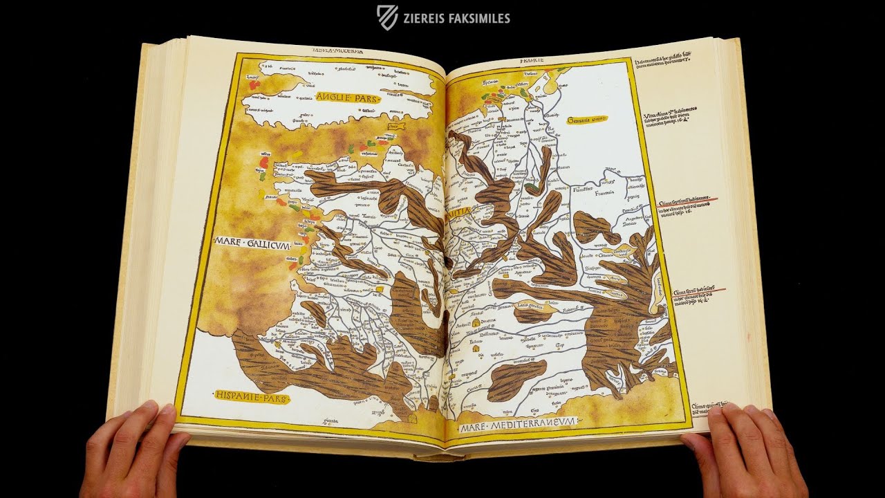
Ulm (Germany) — 1486
The basis for the modern development of German cartography: a beautifully illustrated codex printed in Ulm and based on an Italian manuscript of Ptolemy’s Geography from Wolfegg Castle
Lienhart Holl (d. after 1492) created the first German Ptolemy print in Ulm in 1482
Holl sold his equipment in 1484 to a Venetian bookseller, who was represented in Ulm by Johann Reger (1454 – ca. 1499)
Reger then created a second edition in 1486, which is the same as the first except for the color of the water
Ptolemaei Tabulae Cosmographicae

")
")
")
")
")
")
")
")
")
")
")
")
")
")
")
")
")
")
")
")
")
")
")
")
(1,000€ - 3,000€)
Johann Reger was a printer and agent representing the interests of the Venetian bookseller and publisher Justus de Albano in Ulm. When Lienhart Holl ran into financial difficulties in 1484, he sold the printing press, typefaces, plates, etc. that he had used to make the first German Ptolemy print in 1482 to de Albano. Reger was then commissioned by de Albano with the creation of a second print in 1486, which differs from the first edition only with respect to the color of the water: Holl’s map is dark blue while Reger’s is golden brown, which was probably intentional. They are based on an Italian manuscript of Ptolemy’s Geography, which was edited by the cosmographer Donnus Nicolaus Germanus and was in the possession of the Truchsesses or stewards of Wolfegg Castle ca. 1470 before it was acquired by Holl. The beautifully illustrated printed codex served as the basis for the modern development of German cartography.
The work of Claudius Ptolemy
The second-century astronomer, mathematician, and geographer Claudius Ptolemy wrote a concise treatise on mathematical geography, known as "Geographia", which contained a projection theory as well as the names and coordinates of 8,000 locales of the world as it was then known. His treatise, which was appended with maps at a later date, is counted among the earliest cartographic works of geography in the world. After the work was thought to have been lost for over 1000 years, Ptolemy's treatise resurfaced in Italy around 1400. In 1409, Jacobus Angelus de Scarperia published the first Latin translation of the Greek manuscript under the title "Cosmographia", after which the work initially spread throughout Europe in numerous transcripts and reprints.
The Geographia crosses the Alps
In the German-speaking region, Lienhart Holl was the first printer to take up the Ptolemaic work. In his Ulm print workshop, he spared no expense or effort - early book production required a large outlay of capital - and in 1482 created the first printed atlas north of the Alps. His high-quality colored woodcuts were based on an edition by the Italian Benedictine monk Donnus Nicolaus Germanus, which was in the possession of the Truchsesses of Wolfegg Castle around 1470, and were distinguished by the strong blue color of the water surfaces, astonishingly large type, and exquisite paper. However, this high quality was Holl's undoing; the high costs and the accompanying debt led to the bankruptcy of the printer, who then had to leave the imperial city of Ulm in 1484.
Second edition
However, someone else, namely Justus de Albano, took advantage of this bankruptcy. The Venetian bookseller and publisher was able to acquire Holl's printing blocks and types and had Johann Reger print a second edition in 1486. This one has only one difference: The coloring of the water surfaces. Instead of the dark blue used by Holl, de Albano and Reger opted for golden brown making the two editions easy to distinguish, which was probably the intention of this simple and thus efficient change. At the same time, the choice of color implies a completely different and unusual aesthetic, which now no longer thrives on rich colors and contrasts, but on harmonious earth tones and greater homogeneity.
Codicology
- Size / Format
- 412 pages / 40.0 × 29.0 cm
- Origin
- Germany
- Date
- 1486
- Epochs
- Genre
- Language
- Illustrations
- Numerous illustrations, some double-page maps
- Artist / School
- Printer: Johann Reger
")
Ptolemaei Tabulae Cosmographicae
Crete
The island of Crete is one of the most historically significant locations in the world. First inhabited over 130,000 years ago, it was the home of Europe’s earliest advanced civilization, the Minoans, whose influence on other early Mediterranean civilizations through their extensive maritime trade network is still exhibited by a distinctive style of pottery. The mountainous island with many natural harbors is depicted here in detail with dozens of settlements identified.
")
Ptolemaei Tabulae Cosmographicae
Ecumene
The ecumene or oecumene is an ancient Greek word used for the known world and came to refer to civilization itself under the Roman Empire. Today, it is used in the context of ecumenism, a concept seeking to reconcile the various Christian denominations, and in cartography to describe a category of medieval world maps from Late Antiquity and the Middle Ages.
Printed more than 1,300 years after Ptolemy first wrote his Geography, this codex and others containing this iconic engraving of the Grecco-Roman worldview attest to the lasting influence of the ancient Greek polymath’s most famous work. Unfortunately for early explorers, the image underestimates the Earth’s circumference while overestimating the width of the Eurasian continent.
")
#1 Ptolemaei Tabulae Cosmographicae
Language: Italian
(1,000€ - 3,000€)
")
")
")
")
")
")

- Treatises / Secular Books
- Apocalypses / Beatus
- Astronomy / Astrology
- Bestiaries
- Bibles / Gospels
- Chronicles / History / Law
- Geography / Maps
- Saints' Lives
- Islam / Oriental
- Judaism / Hebrew
- Single Leaf Collections
- Leonardo da Vinci
- Literature / Poetry
- Liturgical Manuscripts
- Medicine / Botany / Alchemy
- Music
- Mythology / Prophecies
- Psalters
- Other Religious Books
- Games / Hunting
- Private Devotion Books
- Other Genres
- Afghanistan
- Armenia
- Austria
- Belgium
- Belize
- Bosnia and Herzegovina
- China
- Colombia
- Costa Rica
- Croatia
- Cyprus
- Czech Republic
- Denmark
- Egypt
- El Salvador
- Ethiopia
- France
- Germany
- Greece
- Guatemala
- Honduras
- Hungary
- India
- Iran
- Iraq
- Israel
- Italy
- Japan
- Jordan
- Kazakhstan
- Kyrgyzstan
- Lebanon
- Liechtenstein
- Luxembourg
- Mexico
- Morocco
- Netherlands
- Palestine
- Panama
- Peru
- Poland
- Portugal
- Romania
- Russia
- Serbia
- Spain
- Sri Lanka
- Sweden
- Switzerland
- Syria
- Tajikistan
- Turkey
- Turkmenistan
- Ukraine
- United Kingdom
- United States
- Uzbekistan
- Vatican City
- A. Oosthoek, van Holkema & Warendorf
- Aboca Museum
- Ajuntament de Valencia
- Akademie Verlag
- Akademische Druck- u. Verlagsanstalt (ADEVA)
- Aldo Ausilio Editore - Bottega d’Erasmo
- Alecto Historical Editions
- Alkuin Verlag
- Almqvist & Wiksell
- Amilcare Pizzi
- Andreas & Andreas Verlagsbuchhandlung
- Archa 90
- Archiv Verlag
- Archivi Edizioni
- Arnold Verlag
- ARS
- Ars Magna
- Ars Millenii
- Art Market
- ArtCodex
- AyN Ediciones
- Azimuth Editions
- Badenia Verlag
- Bärenreiter-Verlag
- Belser Verlag
- Belser Verlag / WK Wertkontor
- Benziger Verlag
- Bernardinum Wydawnictwo
- BiblioGemma
- Biblioteca Apostolica Vaticana (Vaticanstadt, Vaticanstadt)
- Bibliotheca Palatina Faksimile Verlag
- Bibliotheca Rara
- Boydell & Brewer
- Bramante Edizioni
- Bredius Genootschap
- Brepols Publishers
- British Library
- Brokarte
- C. Weckesser
- Caixa Catalunya
- Canesi
- CAPSA, Ars Scriptoria
- Caratzas Brothers, Publishers
- Carus Verlag
- Casamassima Libri
- Centrum Cartographie Verlag GmbH
- Chavane Verlag
- Christian Brandstätter Verlag
- Circulo Cientifico
- Club Bibliófilo Versol
- Club du Livre
- Club Internacional del Libro
- CM Editores
- Collegium Graphicum
- Collezione Apocrifa Da Vinci
- Comissão Nacional para as Comemorações dos Descobrimentos Portugueses
- Coron Verlag
- Corvina
- CTHS
- D. S. Brewer
- Damon
- De Agostini/UTET
- De Nederlandsche Boekhandel
- De Schutter
- Deuschle & Stemmle
- Deutscher Verlag für Kunstwissenschaft
- DIAMM
- Dropmore Press
- Droz
- E. Schreiber Graphische Kunstanstalten
- Ediciones Boreal
- Ediciones Grial
- Ediclube
- Edições Inapa
- Edilan
- Editalia
- Edition Deuschle
- Edition Georg Popp
- Edition Leipzig
- Edition Libri Illustri
- Editiones Reales Sitios S. L.
- Éditions de l'Oiseau Lyre
- Editions Medicina Rara
- Editorial Casariego
- Editorial Mintzoa
- Editrice Antenore
- Editrice Velar
- Edizioni Edison
- Egeria, S.L.
- Eikon Editores
- Electa
- Emery Walker Limited
- Enciclopèdia Catalana
- Eos-Verlag
- Ephesus Publishing
- Ernst Battenberg
- Eugrammia Press
- Extraordinary Editions
- Fackelverlag
- Facsimila Art & Edition
- Facsimile Editions Ltd.
- Facsimilia Art & Edition Ebert KG
- Faksimile Verlag
- Feuermann Verlag
- Folger Shakespeare Library
- Franco Cosimo Panini Editore
- Friedrich Wittig Verlag
- Fundación Hullera Vasco-Leonesa
- G. Braziller
- Gabriele Mazzotta Editore
- Gebr. Mann Verlag
- Gesellschaft für graphische Industrie
- Getty Research Institute
- Giovanni Domenico de Rossi
- Giunti Editore
- Goldenmark Librarium
- Graffiti
- Grafica European Center of Fine Arts
- Guido Pressler
- Guillermo Blazquez
- Gustav Kiepenheuer
- H. N. Abrams
- Harrassowitz
- Harvard University Press
- Helikon
- Hendrickson Publishers
- Henning Oppermann
- Herder Verlag
- Hes & De Graaf Publishers
- Hoepli
- Holbein-Verlag
- Houghton Library
- Hugo Schmidt Verlag
- Hungarian Academy of Sciences
- Idion Verlag
- Il Bulino, edizioni d'arte
- ILte
- Imago
- Insel Verlag
- Insel-Verlag Anton Kippenberger
- Instituto de Estudios Altoaragoneses
- Instituto Nacional de Antropología e Historia
- Introligatornia Budnik Jerzy
- Istituto dell'Enciclopedia Italiana - Treccani
- Istituto Ellenico di Studi Bizantini e Postbizantini
- Istituto Geografico De Agostini
- Istituto Poligrafico e Zecca dello Stato
- Italarte Art Establishments
- Jaca Book
- Jan Thorbecke Verlag
- Johnson Reprint Corporation
- Johnson Reprint Corporation
- Jos. Baer
- Josef Stocker
- Josef Stocker-Schmid
- Jugoslavija
- Karl W. Hiersemann
- Kasper Straube
- Kaydeda Ediciones
- Kindler Verlag / Coron Verlag
- Kodansha International Ltd.
- Konrad Kölbl Verlag
- Kurt Wolff Verlag
- La Liberia dello Stato
- La Linea Editrice
- La Meta Editore
- Lambert Schneider
- Landeskreditbank Baden-Württemberg
- Leo S. Olschki
- Les Incunables
- Liber Artis
- Library of Congress
- Libreria Musicale Italiana
- Lichtdruck
- Lito Immagine Editore
- Lumen Artis
- Lund Humphries
- M. Moleiro Editor
- Maison des Sciences de l'homme et de la société de Poitiers
- Manuscriptum
- Martinus Nijhoff
- Maruzen-Yushodo Co. Ltd.
- MASA
- Massada Publishers
- McGraw-Hill
- Metropolitan Museum of Art
- Militos
- Millennium Liber
- Müller & Schindler
- Nahar - Stavit
- Nahar and Steimatzky
- National Library of Wales
- Neri Pozza
- Nova Charta
- Oceanum Verlag
- Odeon
- Omnia Arte
- Orbis Mediaevalis
- Orbis Pictus
- Österreichische Staatsdruckerei
- Oxford University Press
- Pageant Books
- Parzellers Buchverlag
- Patrimonio Ediciones
- Pattloch Verlag
- PIAF
- Pieper Verlag
- Plon-Nourrit et cie
- Poligrafiche Bolis
- Presses Universitaires de Strasbourg
- Prestel Verlag
- Princeton University Press
- Prisma Verlag
- Priuli & Verlucca, editori
- Pro Sport Verlag
- Propyläen Verlag
- Pytheas Books
- Quaternio Verlag Luzern
- Reales Sitios
- Recht-Verlag
- Reichert Verlag
- Reichsdruckerei
- Reprint Verlag
- Riehn & Reusch
- Roberto Vattori Editore
- Rosenkilde and Bagger
- Roxburghe Club
- Salerno Editrice
- Saltellus Press
- Sandoz
- Sarajevo Svjetlost
- Schöck ArtPrint Kft.
- Schulsinger Brothers
- Scolar Press
- Scrinium
- Scripta Maneant
- Scriptorium
- Shazar
- Siloé, arte y bibliofilia
- SISMEL - Edizioni del Galluzzo
- Sociedad Mexicana de Antropología
- Société des Bibliophiles & Iconophiles de Belgique
- Soncin Publishing
- Sorli Ediciones
- Stainer and Bell
- Studer
- Styria Verlag
- Sumptibus Pragopress
- Szegedi Tudomànyegyetem
- Taberna Libraria
- Tarshish Books
- Taschen
- Tempus Libri
- Testimonio Compañía Editorial
- TGB Limited Editions
- Thames and Hudson
- The Clear Vue Publishing Partnership Limited
- The Facsimile Codex
- The Folio Society
- The Marquess of Normanby
- The Orphan Hospital Ward of Israel
- The Richard III and Yorkist History Trust
- The Warburg Institute
- Tip.Le.Co
- TouchArt
- TREC Publishing House
- TRI Publishing Co.
- Trident Editore
- Tuliba Collection
- Typis Regiae Officinae Polygraphicae
- Union Verlag Berlin
- Universidad de Granada
- Universitaire Bibliotheken Leiden
- University of California Press
- University of Chicago Press
- Urs Graf
- Vallecchi
- Van Wijnen
- VCH, Acta Humaniora
- VDI Verlag
- VEB Deutscher Verlag für Musik
- Verein Schweizerischer Lithographie-Besitzer
- Verlag Anton Pustet / Andreas Verlag
- Verlag Bibliophile Drucke Josef Stocker
- Verlag der Münchner Drucke
- Verlag für Regionalgeschichte
- Verlag Styria
- Vicent Garcia Editores
- W. Turnowsky
- Waanders Printers
- Wiener Mechitharisten-Congregation (Wien, Österreich)
- Wissenschaftliche Buchgesellschaft
- Wissenschaftliche Verlagsgesellschaft
- Wydawnictwo Dolnoslaskie
- Xuntanza Editorial
- Zakład Narodowy
- Zollikofer AG