Vesconte Maggiolo - The Nautical Atlas of 1512
")
Genoa (Italy) — 1512
From the Cape of Good Hope to the stormy North Sea: the latest geographic findings of the Renaissance in four sumptuously illuminated portolan maps by the Genoese cartographer Visconte Maggiolo
Visconte Maggiolo (1478 – after 1549) was a Genoese-born sailor and cartographer who moved to Naples in 1511
Although specializing in mapping the Mediteranean, Maggiolo was the first to record the name of the South American river Rio de Amaxones
These four maps depict the northern, western, and southern coasts of Africa, the Mediterranean and Black Seas, and Western Europe
Vesconte Maggiolo - The Nautical Atlas of 1512

")
")
")
")
")
")
")
")
")
")
")
")
")
")
")
")
")
(1,000€ - 3,000€)
Vesconte Maggiolo, also spelled Maiollo and Maiolo, was an Italian cartographer who was active in his native Genoa as well as Naples during the first half of the 16th century. He produced numerous portolan charts, nautical atlases, and other works of cartography that have survived to the present day and is credited with being the first to record the name of the Amazon River in 1548. In 1512, only a year after moving to Naples, Maggiolo created a set of four parchment maps, which are stored today in the Biblioteca Palatina in Parma, Italy. The four double-page maps are richly illuminated with gold and lush colors and depict the north, west and south coasts of Africa, the Mediterranean and the Black Sea, as well as Western Europe. As such, the nautical atlas is a wonderful testimony to the geographical knowledge of the Renaissance and one of the most ornate specimens of Italian cartography from the Age of Exploration.
Vesconte Maggiolo – The Nautical Atlas of 1512
Maggiolo’s famous Nautical Atlas of 1512 consists of four masterful pieces of cartography that are also fine specimens of Italian Renaissance art. They are painted with a beautiful palette of primary colors that are illuminated with gold. First is a detailed map of Africa and its northern, western, and southern coasts as well as the neighboring regions of the Mediterranean and Europe. The second map shows the Black Sea and Asia Minor as well as Greece and the Eastern Mediterranean while the third map shows the Central and Western Mediterranean, the Peloponnese, and Crete. Finally, the fourth map shows the North Sea and Atlantic coasts of Western Europe, the British Isles, and North Africa.
The Life of a Master Cartographer
Vesconte Maggiolo (1478 – after 1549) was born into the Republic of Genoa, one of the great maritime powers of medieval Italy and an important center of banking during his lifetime. Not only was he born into a family of mapmakers, but one that was granted a monopoly by the Republic for over 150 years to ensure the consistent quality of these important navigational tools. As such, he was destined to be one of the greatest cartographers of the 16th century. He moved to Naples in 1511, presumably to expand the family business to the city, which was enjoying an economic and cultural revival under the rule of the Crown of Aragon.
While in Naples, he produced inter alia two atlases, three nautical charts, and a nautical planisphere before he was recalled to Genoa by Doge Ottaviano Fregoso in 1518. Maggiolo was made Magister cartarum pro navigando a position that came with a salary of 100 lire per year. In 1521, the Genoese Senate confirmed his office and salary for life and in 1529 he was granted the right to pass it onto his son. Maggiolo’s last known work was published in 1549, a year after he became the first person to use the term Rio de Amaxones to refer to the mightiest river in South America on a map.
Codicology
- Alternative Titles
- Vesconte Maggiolo Atlante nautico del 1512
Vesconte Maggiolo - Der Seeatlas von 1512 - Type
- Map on parchment
- Size / Format
- 8 pages / 24.0 × 34.0 cm
- Origin
- Italy
- Date
- 1512
- Epochs
- Style
- Genre
- Language
- Illustrations
- 4 gold decorated double-page nautical charts
- Content
- Nautical charts of Africa, Europe and its Atlantic coast and the Mediterranean Sea
- Artist / School
- Vesconte Maggiolo
")
Vesconte Maggiolo - The Nautical Atlas of 1512
Genoa and Venice
Here we see the two great maritime powers of the Middle Ages: Genoa is in the foreground and is depicted with its port in a fairly accurate manner while Venice is only recognizable by St. Mark’s Campanile, which towers over the city. The two republics also competed with one another for titles with Venice being known as La Serenissima or “the Most Serene Republic of Venice” while Genoa claimed various titles including la Superba, la Dominante, and la Repubblica dei magnifici or “the Republic of the Magnificents”.
")
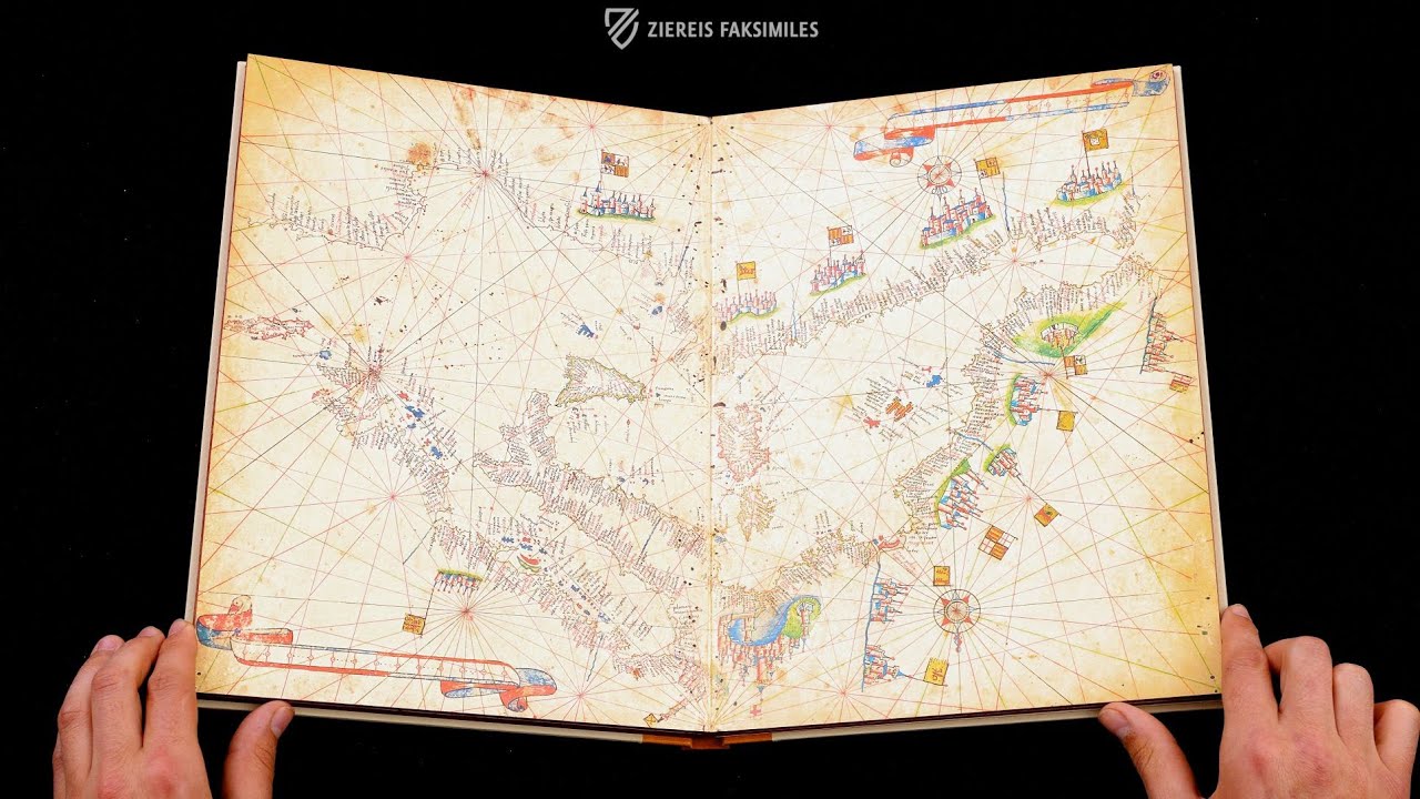
Vesconte Maggiolo - The Nautical Atlas of 1512
Africa, Europe, and the Middle East
Large maps like these were designed to be viewed from all sides meaning that although the labels in the upper part of this map appear upside down to us, they would be legible for someone standing next to the upper edge of the map just as the place names in Sub-Saharan Africa including “Mons Lune”, which is depicted as the origin of the Nile River and possible location of the Garden of Eden, which is represented by a snake climbing up a tree inside of a castle.
Various rulers are depicted either enthroned or seated within elaborately colored tents. Aside from Genoa and Venice, other important trade cities are depicted along the coasts of the Red Sea, which is colored literally, as well as five more cites along the Danube River. The ancient cities of Aleppo, Damascus, and Jerusalem are depicted in the Holy Land in the East while newly discovered Atlantic Islands such as the Canaries and Azores are drawn in red and blue in the West.
")
#1 Der Seeatlas des Vesconte Maggiolo vom Jahre 1512
Language: German
(1,000€ - 3,000€)
")
")
")
")
")
")

- Treatises / Secular Books
- Apocalypses / Beatus
- Astronomy / Astrology
- Bestiaries
- Bibles / Gospels
- Chronicles / History / Law
- Geography / Maps
- Saints' Lives
- Islam / Oriental
- Judaism / Hebrew
- Single Leaf Collections
- Leonardo da Vinci
- Literature / Poetry
- Liturgical Manuscripts
- Medicine / Botany / Alchemy
- Music
- Mythology / Prophecies
- Psalters
- Other Religious Books
- Games / Hunting
- Private Devotion Books
- Other Genres
- Afghanistan
- Armenia
- Austria
- Belgium
- Belize
- Bosnia and Herzegovina
- China
- Colombia
- Costa Rica
- Croatia
- Cyprus
- Czech Republic
- Denmark
- Egypt
- El Salvador
- Ethiopia
- France
- Germany
- Greece
- Guatemala
- Honduras
- Hungary
- India
- Iran
- Iraq
- Israel
- Italy
- Japan
- Jordan
- Kazakhstan
- Kyrgyzstan
- Lebanon
- Liechtenstein
- Luxembourg
- Mexico
- Morocco
- Netherlands
- Palestine
- Panama
- Peru
- Poland
- Portugal
- Romania
- Russia
- Serbia
- Spain
- Sri Lanka
- Sweden
- Switzerland
- Syria
- Tajikistan
- Turkey
- Turkmenistan
- Ukraine
- United Kingdom
- United States
- Uzbekistan
- Vatican City
- A. Oosthoek, van Holkema & Warendorf
- Aboca Museum
- Ajuntament de Valencia
- Akademie Verlag
- Akademische Druck- u. Verlagsanstalt (ADEVA)
- Aldo Ausilio Editore - Bottega d’Erasmo
- Alecto Historical Editions
- Alkuin Verlag
- Almqvist & Wiksell
- Amilcare Pizzi
- Andreas & Andreas Verlagsbuchhandlung
- Archa 90
- Archiv Verlag
- Archivi Edizioni
- Arnold Verlag
- ARS
- Ars Magna
- Ars Millenii
- Art Market
- ArtCodex
- AyN Ediciones
- Azimuth Editions
- Badenia Verlag
- Bärenreiter-Verlag
- Belser Verlag
- Belser Verlag / WK Wertkontor
- Benziger Verlag
- Bernardinum Wydawnictwo
- BiblioGemma
- Biblioteca Apostolica Vaticana (Vaticanstadt, Vaticanstadt)
- Bibliotheca Palatina Faksimile Verlag
- Bibliotheca Rara
- Boydell & Brewer
- Bramante Edizioni
- Bredius Genootschap
- Brepols Publishers
- British Library
- Brokarte
- C. Weckesser
- Caixa Catalunya
- Canesi
- CAPSA, Ars Scriptoria
- Caratzas Brothers, Publishers
- Carus Verlag
- Casamassima Libri
- Centrum Cartographie Verlag GmbH
- Chavane Verlag
- Christian Brandstätter Verlag
- Circulo Cientifico
- Club Bibliófilo Versol
- Club du Livre
- Club Internacional del Libro
- CM Editores
- Collegium Graphicum
- Collezione Apocrifa Da Vinci
- Comissão Nacional para as Comemorações dos Descobrimentos Portugueses
- Coron Verlag
- Corvina
- CTHS
- D. S. Brewer
- Damon
- De Agostini/UTET
- De Nederlandsche Boekhandel
- De Schutter
- Deuschle & Stemmle
- Deutscher Verlag für Kunstwissenschaft
- DIAMM
- Dropmore Press
- Droz
- E. Schreiber Graphische Kunstanstalten
- Ediciones Boreal
- Ediciones Grial
- Ediclube
- Edições Inapa
- Edilan
- Editalia
- Edition Deuschle
- Edition Georg Popp
- Edition Leipzig
- Edition Libri Illustri
- Editiones Reales Sitios S. L.
- Éditions de l'Oiseau Lyre
- Editions Medicina Rara
- Editorial Casariego
- Editorial Mintzoa
- Editrice Antenore
- Editrice Velar
- Edizioni Edison
- Egeria, S.L.
- Eikon Editores
- Electa
- Emery Walker Limited
- Enciclopèdia Catalana
- Eos-Verlag
- Ephesus Publishing
- Ernst Battenberg
- Eugrammia Press
- Extraordinary Editions
- Fackelverlag
- Facsimila Art & Edition
- Facsimile Editions Ltd.
- Facsimilia Art & Edition Ebert KG
- Faksimile Verlag
- Feuermann Verlag
- Folger Shakespeare Library
- Franco Cosimo Panini Editore
- Friedrich Wittig Verlag
- Fundación Hullera Vasco-Leonesa
- G. Braziller
- Gabriele Mazzotta Editore
- Gebr. Mann Verlag
- Gesellschaft für graphische Industrie
- Getty Research Institute
- Giovanni Domenico de Rossi
- Giunti Editore
- Goldenmark Librarium
- Graffiti
- Grafica European Center of Fine Arts
- Guido Pressler
- Guillermo Blazquez
- Gustav Kiepenheuer
- H. N. Abrams
- Harrassowitz
- Harvard University Press
- Helikon
- Hendrickson Publishers
- Henning Oppermann
- Herder Verlag
- Hes & De Graaf Publishers
- Hoepli
- Holbein-Verlag
- Houghton Library
- Hugo Schmidt Verlag
- Hungarian Academy of Sciences
- Idion Verlag
- Il Bulino, edizioni d'arte
- ILte
- Imago
- Insel Verlag
- Insel-Verlag Anton Kippenberger
- Instituto de Estudios Altoaragoneses
- Instituto Nacional de Antropología e Historia
- Introligatornia Budnik Jerzy
- Istituto dell'Enciclopedia Italiana - Treccani
- Istituto Ellenico di Studi Bizantini e Postbizantini
- Istituto Geografico De Agostini
- Istituto Poligrafico e Zecca dello Stato
- Italarte Art Establishments
- Jaca Book
- Jan Thorbecke Verlag
- Johnson Reprint Corporation
- Johnson Reprint Corporation
- Jos. Baer
- Josef Stocker
- Josef Stocker-Schmid
- Jugoslavija
- Karl W. Hiersemann
- Kasper Straube
- Kaydeda Ediciones
- Kindler Verlag / Coron Verlag
- Kodansha International Ltd.
- Konrad Kölbl Verlag
- Kurt Wolff Verlag
- La Liberia dello Stato
- La Linea Editrice
- La Meta Editore
- Lambert Schneider
- Landeskreditbank Baden-Württemberg
- Leo S. Olschki
- Les Incunables
- Liber Artis
- Library of Congress
- Libreria Musicale Italiana
- Lichtdruck
- Lito Immagine Editore
- Lumen Artis
- Lund Humphries
- M. Moleiro Editor
- Maison des Sciences de l'homme et de la société de Poitiers
- Manuscriptum
- Martinus Nijhoff
- Maruzen-Yushodo Co. Ltd.
- MASA
- Massada Publishers
- McGraw-Hill
- Metropolitan Museum of Art
- Militos
- Millennium Liber
- Müller & Schindler
- Nahar - Stavit
- Nahar and Steimatzky
- National Library of Wales
- Neri Pozza
- Nova Charta
- Oceanum Verlag
- Odeon
- Omnia Arte
- Orbis Mediaevalis
- Orbis Pictus
- Österreichische Staatsdruckerei
- Oxford University Press
- Pageant Books
- Parzellers Buchverlag
- Patrimonio Ediciones
- Pattloch Verlag
- PIAF
- Pieper Verlag
- Plon-Nourrit et cie
- Poligrafiche Bolis
- Presses Universitaires de Strasbourg
- Prestel Verlag
- Princeton University Press
- Prisma Verlag
- Priuli & Verlucca, editori
- Pro Sport Verlag
- Propyläen Verlag
- Pytheas Books
- Quaternio Verlag Luzern
- Reales Sitios
- Recht-Verlag
- Reichert Verlag
- Reichsdruckerei
- Reprint Verlag
- Riehn & Reusch
- Roberto Vattori Editore
- Rosenkilde and Bagger
- Roxburghe Club
- Salerno Editrice
- Saltellus Press
- Sandoz
- Sarajevo Svjetlost
- Schöck ArtPrint Kft.
- Schulsinger Brothers
- Scolar Press
- Scrinium
- Scripta Maneant
- Scriptorium
- Shazar
- Siloé, arte y bibliofilia
- SISMEL - Edizioni del Galluzzo
- Sociedad Mexicana de Antropología
- Société des Bibliophiles & Iconophiles de Belgique
- Soncin Publishing
- Sorli Ediciones
- Stainer and Bell
- Studer
- Styria Verlag
- Sumptibus Pragopress
- Szegedi Tudomànyegyetem
- Taberna Libraria
- Tarshish Books
- Taschen
- Tempus Libri
- Testimonio Compañía Editorial
- TGB Limited Editions
- Thames and Hudson
- The Clear Vue Publishing Partnership Limited
- The Facsimile Codex
- The Folio Society
- The Marquess of Normanby
- The Orphan Hospital Ward of Israel
- The Richard III and Yorkist History Trust
- The Warburg Institute
- Tip.Le.Co
- TouchArt
- TREC Publishing House
- TRI Publishing Co.
- Trident Editore
- Tuliba Collection
- Typis Regiae Officinae Polygraphicae
- Union Verlag Berlin
- Universidad de Granada
- Universitaire Bibliotheken Leiden
- University of California Press
- University of Chicago Press
- Urs Graf
- Vallecchi
- Van Wijnen
- VCH, Acta Humaniora
- VDI Verlag
- VEB Deutscher Verlag für Musik
- Verein Schweizerischer Lithographie-Besitzer
- Verlag Anton Pustet / Andreas Verlag
- Verlag Bibliophile Drucke Josef Stocker
- Verlag der Münchner Drucke
- Verlag für Regionalgeschichte
- Verlag Styria
- Vicent Garcia Editores
- W. Turnowsky
- Waanders Printers
- Wiener Mechitharisten-Congregation (Wien, Österreich)
- Wissenschaftliche Buchgesellschaft
- Wissenschaftliche Verlagsgesellschaft
- Wydawnictwo Dolnoslaskie
- Xuntanza Editorial
- Zakład Narodowy
- Zollikofer AG