Catalan Atlas
")
Mallorca (Spain) — 1375
The first complete depiction of the world as it was then known on twelve parchment plates measuring over three meters in length: this mappa mundi represents the pinnacle of medieval cartography and the most important contemporary map of Africa
Abraham Cresques (1325–87) and his son Jehuda (1360–1410) created the extraordinary map in 1375
It was commissioned a gift from the future king of Aragon to the future king of France
Human figures, ships, cities, and ports are painted in rich colors and illuminated with gold and silver
Catalan Atlas

")
")
")
")
")
")
")
")
")
")
")
")
")
")
")
")
")
")
")
")
")
")
")
")
")
")
")
(1,000€ - 3,000€)
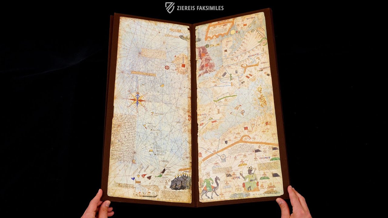
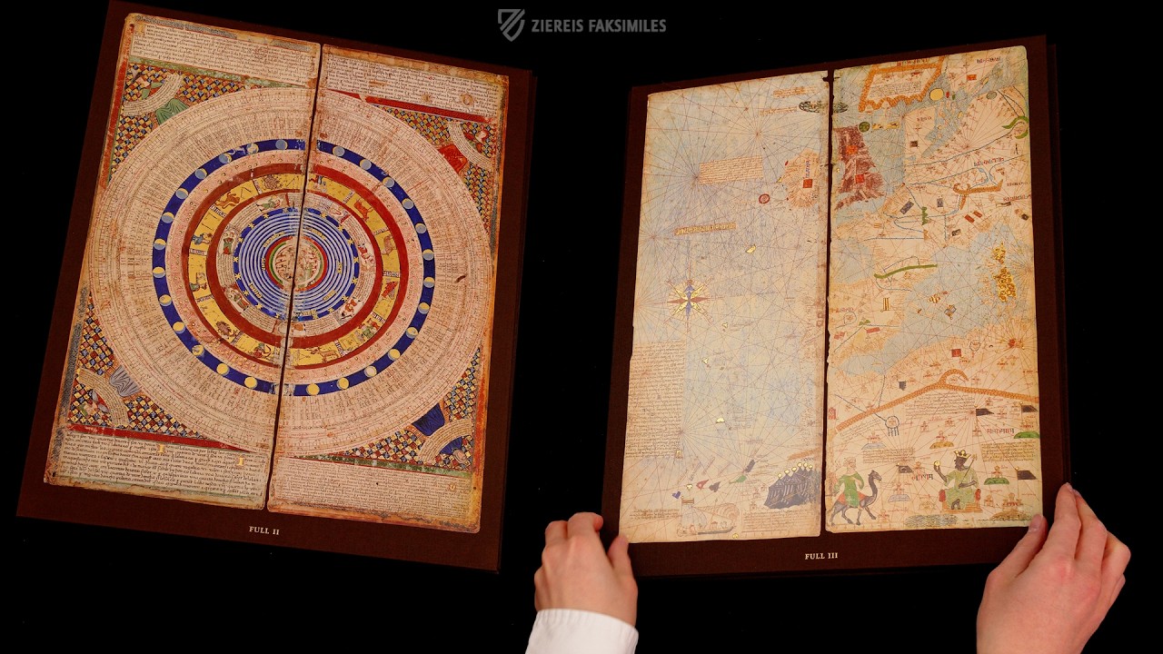
The Catalan Atlas, a true milestone of cartography was created in 1375 by Abraham Cresques, a Jewish master mapmaker and maker of clocks, compasses, and other nautical instruments from Palma, Mallorca. Working at the behest of Prince John, the future King of Aragon, Cresques and his son Jehuda undertook the creation of a set of nautical charts intended to surpass all contemporaries and to be presented as a royal gift to John’s cousin, the future King Charles IV of France. The work consists of six vellum folios, richly painted and illuminated with gold and silver. Its first two leaves contain illustrated Catalan texts on cosmography, astronomy, and astrology, emphasizing the spherical nature of the Earth. The four remaining leaves comprise the map itself, which is remarkably accurate and features the first ornate compass rose to be depicted on a map. Cresques also incorporated information from the travelogues of Marco Polo and Sir John Mandeville. To protect the work, it was mounted on five wooden panels joined end to end and enclosed in a leather binding created by Simon Vostre around 1515.
Catalan Atlas
This famous portolan atlas depicts the world from the Atlantic to China as it was known to Europeans ca. 1375. While the maps of Europe, North Africa, and the Middle East are fairly accurate and useful, the maps of Asia much less though, although many Indian and Chinese cities can be identified. The Asian maps represent a synthesis of medieval mappae mundi and travel literature, notably Marco Polo's Il Milione and the Travels and Voyage of Sir John Mandeville, and contain numerous religious references. Abraham Cresques (1325–1387), whose proper name was Cresques (son of) Abraham, is credited with creating this masterpiece of the Mallorcan cartographic school – the first known atlas to incorporate a compass rose – in his workshop in Palma.
A Gift Fit for a King
The evidence attributing the map to Cresques and his son Jehuda is circumstantial because there is no signature or other mark indicating who made it. However, in November of 1381, a young John I of Aragon (1350–96), who was Duke of Gerona at the time, wanted to send a splendid gift to the newly crowned King Charles VI of France (1368–1422), who was also a first cousin of his wife Violant de Bar. The Crown of Aragon often gave elaborately decorated maps as gifts and the Cresques were known to have produced several of these maps during the period. Furthermore, a letter from Duke John calls on “Cresque the Jew who made said world map” and his son to provide him with useful information that he can in turn give to the emissary of the King of France. The father-son team was paid 150 Aragonese Florins and 60 Mallorcan pounds for their work on the atlas.
An Exemplary Specimen of the Mallorcan School
The Catalan Atlas consists of six vertically folded leaves of fine vellum painted with expensive paints, gold, and silver and measuring ca. 64.5 × 50 cm that when assembled create a world map centered on the Mediterranean measuring 65 × 300 cm. Aside from its beauty it also contains numerous features typical of the Mallorcan school of cartography. Each city’s allegiance is indicated by a flag and African and Asian kingdoms have images of their sovereigns, usually but not always enthroned. Christian cities are marked with crosses while others have onion shaped domes. Some cities have flags with the Star of David. Red ink is used for the names of important ports while all other are written in black. Wavy blue lines symbolize the swirling waters of the world’s oceans. Overall, the illustrations and text are oriented toward the edges of the map, indicating that it was designed to be laid flat on a large table that the beholder could then walk around and observe from all sides.
Tables and Maps
The first two sheets consist of tables and diagrams for calculating the tides, moveable feast days, and a diagram of the so-called Zodiac Man (first sheet) as well as a lunisolar calendar for calculating the phases of the Moon throughout the year with zodiac signs, accompanying texts and representations of the four seasons in the corners (second sheet). Beginning in the West, sheets three through six contain four maps spanning from 10° to 60° north latitude and between 20° west and 120° east longitude, thus the Southern Hemisphere is omitted. As the maps move eastward, the lack of geographical information is compensated for by rich ornamentation that simultaneously fills the empty space and fueled the curiosity of the people of medieval Europe towards the wide and fabled lands of the East. This includes miniatures depicting Kublai Kahn, the creation of man, Gog and Magog, Alexander the Great, and even the Antichrist.
Codicology
- Alternative Titles
- Atlas Abraham Cresques
Atlas catalán
Katalanischer Weltatlas
Katalanische Weltkarte von 1375 - Type
- Map on parchment
- Size / Format
- 12 pages / 64.5 × 27.0 cm each
- Origin
- Spain
- Date
- 1375
- Epochs
- Style
- Genre
- Language
- Illustrations
- 12 magnificent folios decorated with gold
- Artist / School
- Cartographer: Abraham Cresques
")
")
")
Catalan Atlas
Desert Caravan
The caption above this colorful caravan of camels loaded with goods followed by servants on foot and merchants on horseback reads: “This caravan left the empire of Sarra to go to Cathay.” Up until the early modern period, Cathay was the word used for China but the identity of Sarra is less clear. However, a neighboring passage says that travelers stop and rest for up to a week in a town called Lop, which could correspond to the Lop Desert in western China. The passage also claims that travelers who get separated from their companions at night can be deceived by the voices of demons and be led astray in the desert.
")
Catalan Atlas
Western Europe and Northwest Africa
The first section of this famous atlas depicts the eastern shores of the Atlantic Ocean as well as the regions surrounding the Western Mediterranean. It stretches from Norway and the Shetland Islands in the North Sea to the deserts of the Sahara, which features a merchant riding a camel past a group of tents. This section is famous inter alia for featuring the first ornate compass rose, which is depicted northwest of the Azores in red, blue, and gold.
The other famous feature of the map is the depiction of Mansa Musa, ruler of the Malian Empire and one of the wealthiest people in history who made a historic hajj to Mecca in 1324. Enthroned at the bottom of the page with a golden crown, scepter, and orb, he is described in the accompanying text as “…the richest and the noblest sovereign of all this region because of the abundance of gold that comes out of the land”.
")
#1 L'atles Català
Language: Spanish
(1,000€ - 3,000€)
#2 Mapamundi. The Catalan Atlas of the Year 1375
")
Languages: English or German
300 copies of the facsimile edition come with an English commentary translated by Dr. B.M. Charleston, professor at the University of Bern.
(1,000€ - 3,000€)
#3 L'atles Català 1375
")
Language: Spanish
")
")
")
")
")
 – Cod. 594 – Österreichische Nationalbibliothek (Vienna, Austria)")
- Treatises / Secular Books
- Apocalypses / Beatus
- Astronomy / Astrology
- Bestiaries
- Bibles / Gospels
- Chronicles / History / Law
- Geography / Maps
- Saints' Lives
- Islam / Oriental
- Judaism / Hebrew
- Single Leaf Collections
- Leonardo da Vinci
- Literature / Poetry
- Liturgical Manuscripts
- Medicine / Botany / Alchemy
- Music
- Mythology / Prophecies
- Psalters
- Other Religious Books
- Games / Hunting
- Private Devotion Books
- Other Genres
- Afghanistan
- Armenia
- Austria
- Belgium
- Belize
- Bosnia and Herzegovina
- China
- Colombia
- Costa Rica
- Croatia
- Cyprus
- Czech Republic
- Denmark
- Egypt
- El Salvador
- Ethiopia
- France
- Germany
- Greece
- Guatemala
- Honduras
- Hungary
- India
- Iran
- Iraq
- Israel
- Italy
- Japan
- Jordan
- Kazakhstan
- Kyrgyzstan
- Lebanon
- Liechtenstein
- Luxembourg
- Mexico
- Morocco
- Netherlands
- Palestine
- Panama
- Peru
- Poland
- Portugal
- Romania
- Russia
- Serbia
- Spain
- Sri Lanka
- Sweden
- Switzerland
- Syria
- Tajikistan
- Turkey
- Turkmenistan
- Ukraine
- United Kingdom
- United States
- Uzbekistan
- Vatican City
- A. Oosthoek, van Holkema & Warendorf
- Aboca Museum
- Ajuntament de Valencia
- Akademie Verlag
- Akademische Druck- u. Verlagsanstalt (ADEVA)
- Aldo Ausilio Editore - Bottega d’Erasmo
- Alecto Historical Editions
- Alkuin Verlag
- Almqvist & Wiksell
- Amilcare Pizzi
- Andreas & Andreas Verlagsbuchhandlung
- Archa 90
- Archiv Verlag
- Archivi Edizioni
- Arnold Verlag
- ARS
- Ars Magna
- Ars Millenii
- Art Market
- ArtCodex
- AyN Ediciones
- Azimuth Editions
- Badenia Verlag
- Bärenreiter-Verlag
- Belser Verlag
- Belser Verlag / WK Wertkontor
- Benziger Verlag
- Bernardinum Wydawnictwo
- BiblioGemma
- Biblioteca Apostolica Vaticana (Vaticanstadt, Vaticanstadt)
- Bibliotheca Palatina Faksimile Verlag
- Bibliotheca Rara
- Boydell & Brewer
- Bramante Edizioni
- Bredius Genootschap
- Brepols Publishers
- British Library
- Brokarte
- C. Weckesser
- Caixa Catalunya
- Canesi
- CAPSA, Ars Scriptoria
- Caratzas Brothers, Publishers
- Carus Verlag
- Casamassima Libri
- Centrum Cartographie Verlag GmbH
- Chavane Verlag
- Christian Brandstätter Verlag
- Circulo Cientifico
- Club Bibliófilo Versol
- Club du Livre
- Club Internacional del Libro
- CM Editores
- Collegium Graphicum
- Collezione Apocrifa Da Vinci
- Comissão Nacional para as Comemorações dos Descobrimentos Portugueses
- Coron Verlag
- Corvina
- CTHS
- D. S. Brewer
- Damon
- De Agostini/UTET
- De Nederlandsche Boekhandel
- De Schutter
- Deuschle & Stemmle
- Deutscher Verlag für Kunstwissenschaft
- DIAMM
- Dropmore Press
- Droz
- E. Schreiber Graphische Kunstanstalten
- Ediciones Boreal
- Ediciones Grial
- Ediclube
- Edições Inapa
- Edilan
- Editalia
- Edition Deuschle
- Edition Georg Popp
- Edition Leipzig
- Edition Libri Illustri
- Editiones Reales Sitios S. L.
- Éditions de l'Oiseau Lyre
- Editions Medicina Rara
- Editorial Casariego
- Editorial Mintzoa
- Editrice Antenore
- Editrice Velar
- Edizioni Edison
- Egeria, S.L.
- Eikon Editores
- Electa
- Emery Walker Limited
- Enciclopèdia Catalana
- Eos-Verlag
- Ephesus Publishing
- Ernst Battenberg
- Eugrammia Press
- Extraordinary Editions
- Fackelverlag
- Facsimila Art & Edition
- Facsimile Editions Ltd.
- Facsimilia Art & Edition Ebert KG
- Faksimile Verlag
- Feuermann Verlag
- Folger Shakespeare Library
- Franco Cosimo Panini Editore
- Friedrich Wittig Verlag
- Fundación Hullera Vasco-Leonesa
- G. Braziller
- Gabriele Mazzotta Editore
- Gebr. Mann Verlag
- Gesellschaft für graphische Industrie
- Getty Research Institute
- Giovanni Domenico de Rossi
- Giunti Editore
- Goldenmark Librarium
- Graffiti
- Grafica European Center of Fine Arts
- Guido Pressler
- Guillermo Blazquez
- Gustav Kiepenheuer
- H. N. Abrams
- Harrassowitz
- Harvard University Press
- Helikon
- Hendrickson Publishers
- Henning Oppermann
- Herder Verlag
- Hes & De Graaf Publishers
- Hoepli
- Holbein-Verlag
- Houghton Library
- Hugo Schmidt Verlag
- Hungarian Academy of Sciences
- Idion Verlag
- Il Bulino, edizioni d'arte
- ILte
- Imago
- Insel Verlag
- Insel-Verlag Anton Kippenberger
- Instituto de Estudios Altoaragoneses
- Instituto Nacional de Antropología e Historia
- Introligatornia Budnik Jerzy
- Istituto dell'Enciclopedia Italiana - Treccani
- Istituto Ellenico di Studi Bizantini e Postbizantini
- Istituto Geografico De Agostini
- Istituto Poligrafico e Zecca dello Stato
- Italarte Art Establishments
- Jaca Book
- Jan Thorbecke Verlag
- Johnson Reprint Corporation
- Johnson Reprint Corporation
- Jos. Baer
- Josef Stocker
- Josef Stocker-Schmid
- Jugoslavija
- Karl W. Hiersemann
- Kasper Straube
- Kaydeda Ediciones
- Kindler Verlag / Coron Verlag
- Kodansha International Ltd.
- Konrad Kölbl Verlag
- Kurt Wolff Verlag
- La Liberia dello Stato
- La Linea Editrice
- La Meta Editore
- Lambert Schneider
- Landeskreditbank Baden-Württemberg
- Leo S. Olschki
- Les Incunables
- Liber Artis
- Library of Congress
- Libreria Musicale Italiana
- Lichtdruck
- Lito Immagine Editore
- Lumen Artis
- Lund Humphries
- M. Moleiro Editor
- Maison des Sciences de l'homme et de la société de Poitiers
- Manuscriptum
- Martinus Nijhoff
- Maruzen-Yushodo Co. Ltd.
- MASA
- Massada Publishers
- McGraw-Hill
- Metropolitan Museum of Art
- Militos
- Millennium Liber
- Müller & Schindler
- Nahar - Stavit
- Nahar and Steimatzky
- National Library of Wales
- Neri Pozza
- Nova Charta
- Oceanum Verlag
- Odeon
- Omnia Arte
- Orbis Mediaevalis
- Orbis Pictus
- Österreichische Staatsdruckerei
- Oxford University Press
- Pageant Books
- Parzellers Buchverlag
- Patrimonio Ediciones
- Pattloch Verlag
- PIAF
- Pieper Verlag
- Plon-Nourrit et cie
- Poligrafiche Bolis
- Presses Universitaires de Strasbourg
- Prestel Verlag
- Princeton University Press
- Prisma Verlag
- Priuli & Verlucca, editori
- Pro Sport Verlag
- Propyläen Verlag
- Pytheas Books
- Quaternio Verlag Luzern
- Reales Sitios
- Recht-Verlag
- Reichert Verlag
- Reichsdruckerei
- Reprint Verlag
- Riehn & Reusch
- Roberto Vattori Editore
- Rosenkilde and Bagger
- Roxburghe Club
- Salerno Editrice
- Saltellus Press
- Sandoz
- Sarajevo Svjetlost
- Schöck ArtPrint Kft.
- Schulsinger Brothers
- Scolar Press
- Scrinium
- Scripta Maneant
- Scriptorium
- Shazar
- Siloé, arte y bibliofilia
- SISMEL - Edizioni del Galluzzo
- Sociedad Mexicana de Antropología
- Société des Bibliophiles & Iconophiles de Belgique
- Soncin Publishing
- Sorli Ediciones
- Stainer and Bell
- Studer
- Styria Verlag
- Sumptibus Pragopress
- Szegedi Tudomànyegyetem
- Taberna Libraria
- Tarshish Books
- Taschen
- Tempus Libri
- Testimonio Compañía Editorial
- TGB Limited Editions
- Thames and Hudson
- The Clear Vue Publishing Partnership Limited
- The Facsimile Codex
- The Folio Society
- The Marquess of Normanby
- The Orphan Hospital Ward of Israel
- The Richard III and Yorkist History Trust
- The Warburg Institute
- Tip.Le.Co
- TouchArt
- TREC Publishing House
- TRI Publishing Co.
- Trident Editore
- Tuliba Collection
- Typis Regiae Officinae Polygraphicae
- Union Verlag Berlin
- Universidad de Granada
- Universitaire Bibliotheken Leiden
- University of California Press
- University of Chicago Press
- Urs Graf
- Vallecchi
- Van Wijnen
- VCH, Acta Humaniora
- VDI Verlag
- VEB Deutscher Verlag für Musik
- Verein Schweizerischer Lithographie-Besitzer
- Verlag Anton Pustet / Andreas Verlag
- Verlag Bibliophile Drucke Josef Stocker
- Verlag der Münchner Drucke
- Verlag für Regionalgeschichte
- Verlag Styria
- Vicent Garcia Editores
- W. Turnowsky
- Waanders Printers
- Wiener Mechitharisten-Congregation (Wien, Österreich)
- Wissenschaftliche Buchgesellschaft
- Wissenschaftliche Verlagsgesellschaft
- Wydawnictwo Dolnoslaskie
- Xuntanza Editorial
- Zakład Narodowy
- Zollikofer AG