Portulan C.G.A.5.b
")
Mallorca (Spain) — 1450–1460
Precise coastlines, important landmarks for practical use at sea, and recent discoveries along the African coast: an impressive set of medieval maps from the renowned Majorcan cartographic school of the mid-15th century
This map originated between 1450 and 1460 in the Majorcan school of cartography for practical use at sea
The most renowned school of geography and cartography took shape in Spain to record new discoveries
These cartographers were able to create some incredibly detailed maps without modern technical aids
Portulan C.G.A.5.b

")
")
")
")
")
")
")
")
")
")
")
")
")
")
")
")
")
(3,000€ - 7,000€)
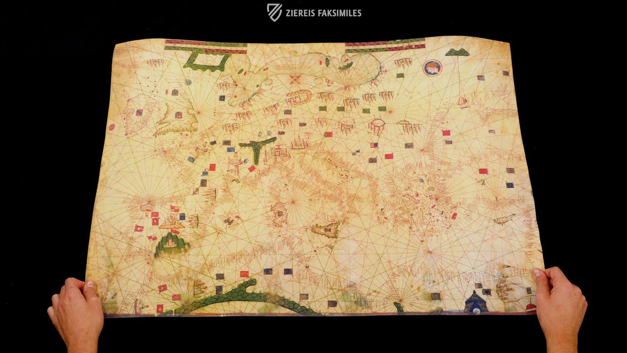
This set brings together three remarkable portolan charts from the 15th century, offering a fascinating insight into the development of late medieval and early Renaissance cartography. The Portulans C.G.A.5.b and C.G.A.5.d, created around 1450–1460 in the renowned Majorcan school, testify to the height of its production, combining detailed coastlines with important trading cities such as Barcelona and Genoa, as well as significant landmarks including castles and mountains. While their decoration ranges from restrained to more elaborate, both maps were clearly intended for practical navigation at sea. The Portulan C.G.A.5.c, produced between 1472 and 1482 by an anonymous Portuguese cartographer, represents the earliest evidence of the emerging Portuguese school, famous for its striking realism. It incorporates recent discoveries along the African coast and highlights key centers such as Lisbon and Ceuta. Together, these maps, now preserved in the Biblioteca Estense in Modena, vividly illustrate the transition from medieval to Renaissance cartographic practice.
Portulan C.G.A.5.b
In the 15th century, Spain and Portugal were the lands under whose flags the most expeditions into largely unexplored regions of the world were made. In the course of many expeditions and discoveries, the most renowned school of geography and cartography in Europe took shape in Spain. The maps, which originated during the time of the awakening Renaissance, belong among the most important geographical material of the entire Middle Ages. It is truly astounding, how true to detail and correct the Spanish and Portuguese cartographers could represent the regions of the world they studied, and completely without the modern technical aids of our time. The Portulan C.G.A.5.b is an outstanding example of the excellent work of medieval scholars.
What is a Portulan?
The term portulan or portolan originally indicated a book with nautical information such as landmarks, lighthouses, currents, and harbor conditions. According to historical sources, such sea-books already existed in the 13th century. Beginning in the 16th century, the term broadened and from then on comprised not only the written descriptions, but also the accompanying nautical maps, which were contained in books. Today, the term “portulan chart” indicate a very precise type of map. The map Portulan C.G.A.5.b is one of these special maps.
A Characteristic Map
Portulan C.G.A.5.b is a map that has distinguished itself from all the other cartographic material of its time. It has hardly any pictorial decoration, because it was not intended as decoration, but rather as an effective navigational aid. The most important trade cities of Barcelona, Valencia, Santiago de Compostela, Granada, Venice, and Genoa were emphasized in particular. The regions depicted are also recognizable by the depiction of their various flags. Similarly, fortresses, palaces, and other particularities that characterized the geographic regions and for which they were known are pictured.
Codicology
- Alternative Titles
- Portolano CGA5b
Portolan map C.G.A.5.b
Portolan-Karte C.G.A.5.b - Type
- Map on parchment
- Size / Format
- 1 map / 90.0 × 61.0 cm
- Origin
- Spain
- Date
- 1450–1460
- Epochs
- Style
- Genre
- Language
- Script
- Humanistic
- Illustrations
- The map is decorated with various colored flags and coats of arms, landmarks, and pictograms of cities as well as a portrait medallion
")
")
")
Portulan C.G.A.5.b
Genoa
Chinese silk, slaves and grain - These are just three of the "trade goods" with which the Republic of Genoa rose to become one of the leading trading and colonial powers of the Mediterranean between the 11th and 15th centuries. The depiction of its powerful capital Genoa, in Ligurian Zena, more than does justice to this status. Clearly larger than Venice to the right, the important trading centre was even depicted with its old harbour basin, still recognisable today, with the large lighthouse on the western headland. The Ligurian Sea stretches out below, while the city is shielded by the green mountain range of the Alps to the west and north on the map.
")
Portulan C.G.A.5.b
Nautical Chart of the Mediterranean and Northwest Europe
Measuring 61 x 90 cm, this map depicts the Mediterranean basin in its entirety, most of the Black Sea, as well as the Atlantic Ocean from the fjords of Norway to the British Isles to the sandy shores of Morocco. It is less decorated than Portulan C.G.A.5.d but also appears to have been designed for practical use as a navigational tool. The place names are drawn so they can always be read from the edge of the map, thus northern cities, coats of arms, and their labels are drawn/written upside down.
Nonetheless, important cities such as Barcelona, Valencia, Santiago de Compostela, Granada, Venice, and Genoa are drawn and labelled as are numerous smaller cities along the important rivers of Europe or on the Baltic Sea in the north, which is very crudely drawn and represents the limits of the geographic knowledge of the otherwise masterful cartographers of Mallorca, who would have created the map ca. 1450–60
")
#1 Portolani (set of 3 maps in deluxe wooden case, includes C.G.A.5.b)
Language: Italian
(3,000€ - 7,000€)
#2 Portolano C.G.A.5.b (map in tube)
")
Language: Italian
(1,000€ - 3,000€)
#3 Portolani (set of 3 maps in case, includes C.G.A.5.b)
")
Language: Italian
(3,000€ - 7,000€)
")
")
")
")
- Treatises / Secular Books
- Apocalypses / Beatus
- Astronomy / Astrology
- Bestiaries
- Bibles / Gospels
- Chronicles / History / Law
- Geography / Maps
- Saints' Lives
- Islam / Oriental
- Judaism / Hebrew
- Single Leaf Collections
- Leonardo da Vinci
- Literature / Poetry
- Liturgical Manuscripts
- Medicine / Botany / Alchemy
- Music
- Mythology / Prophecies
- Psalters
- Other Religious Books
- Games / Hunting
- Private Devotion Books
- Other Genres
- Afghanistan
- Armenia
- Austria
- Belgium
- Belize
- Bosnia and Herzegovina
- China
- Colombia
- Costa Rica
- Croatia
- Cyprus
- Czech Republic
- Denmark
- Egypt
- El Salvador
- Ethiopia
- France
- Germany
- Greece
- Guatemala
- Honduras
- Hungary
- India
- Iran
- Iraq
- Israel
- Italy
- Japan
- Jordan
- Kazakhstan
- Kyrgyzstan
- Lebanon
- Liechtenstein
- Luxembourg
- Mexico
- Morocco
- Netherlands
- Palestine
- Panama
- Peru
- Poland
- Portugal
- Romania
- Russia
- Serbia
- Spain
- Sri Lanka
- Sweden
- Switzerland
- Syria
- Tajikistan
- Turkey
- Turkmenistan
- Ukraine
- United Kingdom
- United States
- Uzbekistan
- Vatican City
- A. Oosthoek, van Holkema & Warendorf
- Aboca Museum
- Ajuntament de Valencia
- Akademie Verlag
- Akademische Druck- u. Verlagsanstalt (ADEVA)
- Aldo Ausilio Editore - Bottega d’Erasmo
- Alecto Historical Editions
- Alkuin Verlag
- Almqvist & Wiksell
- Amilcare Pizzi
- Andreas & Andreas Verlagsbuchhandlung
- Archa 90
- Archiv Verlag
- Archivi Edizioni
- Arnold Verlag
- ARS
- Ars Magna
- Ars Millenii
- Art Market
- ArtCodex
- AyN Ediciones
- Azimuth Editions
- Badenia Verlag
- Bärenreiter-Verlag
- Belser Verlag
- Belser Verlag / WK Wertkontor
- Benziger Verlag
- Bernardinum Wydawnictwo
- BiblioGemma
- Biblioteca Apostolica Vaticana (Vaticanstadt, Vaticanstadt)
- Bibliotheca Palatina Faksimile Verlag
- Bibliotheca Rara
- Boydell & Brewer
- Bramante Edizioni
- Bredius Genootschap
- Brepols Publishers
- British Library
- Brokarte
- C. Weckesser
- Caixa Catalunya
- Canesi
- CAPSA, Ars Scriptoria
- Caratzas Brothers, Publishers
- Carus Verlag
- Casamassima Libri
- Centrum Cartographie Verlag GmbH
- Chavane Verlag
- Christian Brandstätter Verlag
- Circulo Cientifico
- Club Bibliófilo Versol
- Club du Livre
- Club Internacional del Libro
- CM Editores
- Collegium Graphicum
- Collezione Apocrifa Da Vinci
- Comissão Nacional para as Comemorações dos Descobrimentos Portugueses
- Coron Verlag
- Corvina
- CTHS
- D. S. Brewer
- Damon
- De Agostini/UTET
- De Nederlandsche Boekhandel
- De Schutter
- Deuschle & Stemmle
- Deutscher Verlag für Kunstwissenschaft
- DIAMM
- Dropmore Press
- Droz
- E. Schreiber Graphische Kunstanstalten
- Ediciones Boreal
- Ediciones Grial
- Ediclube
- Edições Inapa
- Edilan
- Editalia
- Edition Deuschle
- Edition Georg Popp
- Edition Leipzig
- Edition Libri Illustri
- Editiones Reales Sitios S. L.
- Éditions de l'Oiseau Lyre
- Editions Medicina Rara
- Editorial Casariego
- Editorial Mintzoa
- Editrice Antenore
- Editrice Velar
- Edizioni Edison
- Egeria, S.L.
- Eikon Editores
- Electa
- Emery Walker Limited
- Enciclopèdia Catalana
- Eos-Verlag
- Ephesus Publishing
- Ernst Battenberg
- Eugrammia Press
- Extraordinary Editions
- Fackelverlag
- Facsimila Art & Edition
- Facsimile Editions Ltd.
- Facsimilia Art & Edition Ebert KG
- Faksimile Verlag
- Feuermann Verlag
- Folger Shakespeare Library
- Franco Cosimo Panini Editore
- Friedrich Wittig Verlag
- Fundación Hullera Vasco-Leonesa
- G. Braziller
- Gabriele Mazzotta Editore
- Gebr. Mann Verlag
- Gesellschaft für graphische Industrie
- Getty Research Institute
- Giovanni Domenico de Rossi
- Giunti Editore
- Goldenmark Librarium
- Graffiti
- Grafica European Center of Fine Arts
- Guido Pressler
- Guillermo Blazquez
- Gustav Kiepenheuer
- H. N. Abrams
- Harrassowitz
- Harvard University Press
- Helikon
- Hendrickson Publishers
- Henning Oppermann
- Herder Verlag
- Hes & De Graaf Publishers
- Hoepli
- Holbein-Verlag
- Houghton Library
- Hugo Schmidt Verlag
- Hungarian Academy of Sciences
- Idion Verlag
- Il Bulino, edizioni d'arte
- ILte
- Imago
- Insel Verlag
- Insel-Verlag Anton Kippenberger
- Instituto de Estudios Altoaragoneses
- Instituto Nacional de Antropología e Historia
- Introligatornia Budnik Jerzy
- Istituto dell'Enciclopedia Italiana - Treccani
- Istituto Ellenico di Studi Bizantini e Postbizantini
- Istituto Geografico De Agostini
- Istituto Poligrafico e Zecca dello Stato
- Italarte Art Establishments
- Jaca Book
- Jan Thorbecke Verlag
- Johnson Reprint Corporation
- Johnson Reprint Corporation
- Jos. Baer
- Josef Stocker
- Josef Stocker-Schmid
- Jugoslavija
- Karl W. Hiersemann
- Kasper Straube
- Kaydeda Ediciones
- Kindler Verlag / Coron Verlag
- Kodansha International Ltd.
- Konrad Kölbl Verlag
- Kurt Wolff Verlag
- La Liberia dello Stato
- La Linea Editrice
- La Meta Editore
- Lambert Schneider
- Landeskreditbank Baden-Württemberg
- Leo S. Olschki
- Les Incunables
- Liber Artis
- Library of Congress
- Libreria Musicale Italiana
- Lichtdruck
- Lito Immagine Editore
- Lumen Artis
- Lund Humphries
- M. Moleiro Editor
- Maison des Sciences de l'homme et de la société de Poitiers
- Manuscriptum
- Martinus Nijhoff
- Maruzen-Yushodo Co. Ltd.
- MASA
- Massada Publishers
- McGraw-Hill
- Metropolitan Museum of Art
- Militos
- Millennium Liber
- Müller & Schindler
- Nahar - Stavit
- Nahar and Steimatzky
- National Library of Wales
- Neri Pozza
- Nova Charta
- Oceanum Verlag
- Odeon
- Omnia Arte
- Orbis Mediaevalis
- Orbis Pictus
- Österreichische Staatsdruckerei
- Oxford University Press
- Pageant Books
- Parzellers Buchverlag
- Patrimonio Ediciones
- Pattloch Verlag
- PIAF
- Pieper Verlag
- Plon-Nourrit et cie
- Poligrafiche Bolis
- Presses Universitaires de Strasbourg
- Prestel Verlag
- Princeton University Press
- Prisma Verlag
- Priuli & Verlucca, editori
- Pro Sport Verlag
- Propyläen Verlag
- Pytheas Books
- Quaternio Verlag Luzern
- Reales Sitios
- Recht-Verlag
- Reichert Verlag
- Reichsdruckerei
- Reprint Verlag
- Riehn & Reusch
- Roberto Vattori Editore
- Rosenkilde and Bagger
- Roxburghe Club
- Salerno Editrice
- Saltellus Press
- Sandoz
- Sarajevo Svjetlost
- Schöck ArtPrint Kft.
- Schulsinger Brothers
- Scolar Press
- Scrinium
- Scripta Maneant
- Scriptorium
- Shazar
- Siloé, arte y bibliofilia
- SISMEL - Edizioni del Galluzzo
- Sociedad Mexicana de Antropología
- Société des Bibliophiles & Iconophiles de Belgique
- Soncin Publishing
- Sorli Ediciones
- Stainer and Bell
- Studer
- Styria Verlag
- Sumptibus Pragopress
- Szegedi Tudomànyegyetem
- Taberna Libraria
- Tarshish Books
- Taschen
- Tempus Libri
- Testimonio Compañía Editorial
- TGB Limited Editions
- Thames and Hudson
- The Clear Vue Publishing Partnership Limited
- The Facsimile Codex
- The Folio Society
- The Marquess of Normanby
- The Orphan Hospital Ward of Israel
- The Richard III and Yorkist History Trust
- The Warburg Institute
- Tip.Le.Co
- TouchArt
- TREC Publishing House
- TRI Publishing Co.
- Trident Editore
- Tuliba Collection
- Typis Regiae Officinae Polygraphicae
- Union Verlag Berlin
- Universidad de Granada
- Universitaire Bibliotheken Leiden
- University of California Press
- University of Chicago Press
- Urs Graf
- Vallecchi
- Van Wijnen
- VCH, Acta Humaniora
- VDI Verlag
- VEB Deutscher Verlag für Musik
- Verein Schweizerischer Lithographie-Besitzer
- Verlag Anton Pustet / Andreas Verlag
- Verlag Bibliophile Drucke Josef Stocker
- Verlag der Münchner Drucke
- Verlag für Regionalgeschichte
- Verlag Styria
- Vicent Garcia Editores
- W. Turnowsky
- Waanders Printers
- Wiener Mechitharisten-Congregation (Wien, Österreich)
- Wissenschaftliche Buchgesellschaft
- Wissenschaftliche Verlagsgesellschaft
- Wydawnictwo Dolnoslaskie
- Xuntanza Editorial
- Zakład Narodowy
- Zollikofer AG