Portolan Atlas of Battista Agnese
")
Venice (Italy) — Ca. 1540
The mapping of sea routes, shallows and harbors based on the latest geographical findings: One of the earliest, most valuable, and most beautifully decorated portolan atlases in the history of cartography
One of the earliest and simultaneously one of the most valuable portolan atlases in world history
The work of Battista Agnese (ca. 1500–64) is characterized by detailed and charmingly illustrated maps of seas and harbors
It also contains a solar declination table, an armillary sphere, a zodiac calendar, and other information
Portolan Atlas of Battista Agnese

")
")
")
")
")
")
")
")
")
")
")
")
")
")
")
")
")
")
")
")
")
")
")
")
(1,000€ - 3,000€)
One of the earliest and simultaneously one of the most valuable atlases in world history was manufactured in Venice in 1540. It is the Portolan Atlas of Battista Agnese. The scientist and highly talented artist created his atlas with the aid of the most modern cartographic information, e.g. he relied on the findings of the circumnavigator Ferdinand Magellan. Alongside incredibly detailed geographic expositions, the portolan atlas distinguishes itself through its charming, splendid pictorial adornment.
Portolan Atlas of Battista Agnese
In the 16th century, Venice was a stronghold of geography and cartography. Some of the most accurate and modern maps of the time were manufactured in Venice. The best and most valuable example thereof is the Portolan Atlas of Battista Agnese. The precious geographic work comprises 30 pages with luxurious depictions of the Earth and its individual regions. Additionally, the atlas contains a table of the declination of the Sun and an armillary sphere, a zodiac calendar, as well as two pages of text with astronomical and cosmographic information. The elaborately designed, precious work is considered to be one of the most detailed and artistically valuable map collections of the Renaissance.
Battista Agnese: Artist and Scientist
Battista Agnese was a cartographer in the Republic of Genoa and lived from the early- to the mid–16th century. Agnese was the leading geographer of a Florentine cartography workshop in Venice. In collaboration with his staff, he created at least 71 atlases and sea charts between 1534 and 1564, all of which were of the highest quality and were purchased exclusively by wealthy buyers. One work by the Venetian master was commissioned by Emperor Charles V for his son Philip II. Agnese’s 1546 Portolan Atlas was the result of an edition of some 30 autographed works. It represented the current geographic knowledge of his time and is considered to be one of the earliest cartographical works of world history. The gorgeously decorated atlas served not only for navigation while travelling, but also for the study of geography in the wealthiest houses of the Renaissance.
Science and Mythology Combined
In his atlas, Agnese depicted the world in an overall map in oval projection that showed the route of the world circumnavigation of Magellan. In doing so, he oriented himself on the newest geographic findings of his time. 12 maps of the atlas demonstrate the artist’s modern and scientifically substantiated work in a special way. The map of the new world with California and the Pacific Ocean, the map of the Atlantic Ocean with Africa and parts of Europe, the map of the Indian Ocean, and the map of Europe are only a few examples of the representational talent and the comprehensive geographic knowledge of the master. The pictorial adornment of the luxurious maps is particularly enchanting. Colorful, luminous depictions with splendid gold embellishments adorn the pages of the atlas. The fanciful images from Greco-Roman mythology lend the atlas an incomparable charm. The scenes show the famous mythological tales of the voyage of Jason and the Argonauts as well as the storms that afflicted them, of Aeneas and his flight to Carthage, and of the god Atlas, who bears the world on his shoulders.
Codicology
- Alternative Titles
- Portolan-Atlas des Battista Agnese
- Type
- Map on parchment
- Size / Format
- 30 pages / 26.0 × 19.0 cm
- Origin
- Italy
- Date
- Ca. 1540
- Epochs
- Style
- Genre
- Language
- Artist / School
- Battista Agnese (ca. 1500–64)
- Previous Owners
- State and University Library of Königsberg
")
Portolan Atlas of Battista Agnese
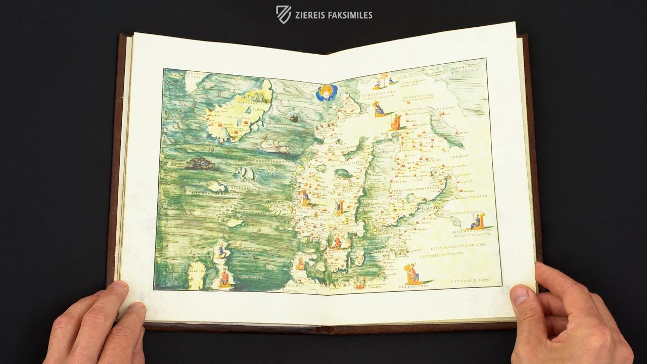
The North Sea
This map of the North Sea not only details the surrounding coasts but even includes smaller islands such as Orkney or the Faroe Islands. Important settlements are marked with red buildings, seated figures represent kings, and Boreas, the Greek god of the cold north wind, can be seen in the upper right corner. The location of Greenland is uncertain, and thus its southern tip appears twice at the top of the page. A sailing ship, a whale, and a giant turtle populate the blue-green waters.
")
Portolan Atlas of Battista Agnese
World Map
This is one of the most popular and copied maps of the world and is significant for three reasons: it represents the most current geographic knowledge of mid–16th century European cartographers, it is rendered in an oval projection resembling a modern map, and it depicts the sea route chosen by Magellan for his circumnavigation of the globe.
Rather than being a practical aid for navigators, this watercolor was intended for display in the homes of the wealthy and educated. It is surprisingly accurate, e.g. it correctly depicts Baja California as a peninsula, unlike many later maps that show it as an island. The Anemoi, ancient Greek wind gods who were each ascribed a cardinal direction from which their respective winds came, frame the map.
")
#1 Portolan Atlas
(1,000€ - 3,000€)
 – National Library of Russia (St. Petersburg, Russia)")
")
")
")
")
")

- Treatises / Secular Books
- Apocalypses / Beatus
- Astronomy / Astrology
- Bestiaries
- Bibles / Gospels
- Chronicles / History / Law
- Geography / Maps
- Saints' Lives
- Islam / Oriental
- Judaism / Hebrew
- Single Leaf Collections
- Leonardo da Vinci
- Literature / Poetry
- Liturgical Manuscripts
- Medicine / Botany / Alchemy
- Music
- Mythology / Prophecies
- Psalters
- Other Religious Books
- Games / Hunting
- Private Devotion Books
- Other Genres
- Afghanistan
- Armenia
- Austria
- Belgium
- Belize
- Bosnia and Herzegovina
- China
- Colombia
- Costa Rica
- Croatia
- Cyprus
- Czech Republic
- Denmark
- Egypt
- El Salvador
- Ethiopia
- France
- Germany
- Greece
- Guatemala
- Honduras
- Hungary
- India
- Iran
- Iraq
- Israel
- Italy
- Japan
- Jordan
- Kazakhstan
- Kyrgyzstan
- Lebanon
- Liechtenstein
- Luxembourg
- Mexico
- Morocco
- Netherlands
- Palestine
- Panama
- Peru
- Poland
- Portugal
- Romania
- Russia
- Serbia
- Spain
- Sri Lanka
- Sweden
- Switzerland
- Syria
- Tajikistan
- Turkey
- Turkmenistan
- Ukraine
- United Kingdom
- United States
- Uzbekistan
- Vatican City
- A. Oosthoek, van Holkema & Warendorf
- Aboca Museum
- Ajuntament de Valencia
- Akademie Verlag
- Akademische Druck- u. Verlagsanstalt (ADEVA)
- Aldo Ausilio Editore - Bottega d’Erasmo
- Alecto Historical Editions
- Alkuin Verlag
- Almqvist & Wiksell
- Amilcare Pizzi
- Andreas & Andreas Verlagsbuchhandlung
- Archa 90
- Archiv Verlag
- Archivi Edizioni
- Arnold Verlag
- ARS
- Ars Magna
- Ars Millenii
- Art Market
- ArtCodex
- AyN Ediciones
- Azimuth Editions
- Badenia Verlag
- Bärenreiter-Verlag
- Belser Verlag
- Belser Verlag / WK Wertkontor
- Benziger Verlag
- Bernardinum Wydawnictwo
- BiblioGemma
- Biblioteca Apostolica Vaticana (Vaticanstadt, Vaticanstadt)
- Bibliotheca Palatina Faksimile Verlag
- Bibliotheca Rara
- Boydell & Brewer
- Bramante Edizioni
- Bredius Genootschap
- Brepols Publishers
- British Library
- Brokarte
- C. Weckesser
- Caixa Catalunya
- Canesi
- CAPSA, Ars Scriptoria
- Caratzas Brothers, Publishers
- Carus Verlag
- Casamassima Libri
- Centrum Cartographie Verlag GmbH
- Chavane Verlag
- Christian Brandstätter Verlag
- Circulo Cientifico
- Club Bibliófilo Versol
- Club du Livre
- Club Internacional del Libro
- CM Editores
- Collegium Graphicum
- Collezione Apocrifa Da Vinci
- Comissão Nacional para as Comemorações dos Descobrimentos Portugueses
- Coron Verlag
- Corvina
- CTHS
- D. S. Brewer
- Damon
- De Agostini/UTET
- De Nederlandsche Boekhandel
- De Schutter
- Deuschle & Stemmle
- Deutscher Verlag für Kunstwissenschaft
- DIAMM
- Dropmore Press
- Droz
- E. Schreiber Graphische Kunstanstalten
- Ediciones Boreal
- Ediciones Grial
- Ediclube
- Edições Inapa
- Edilan
- Editalia
- Edition Deuschle
- Edition Georg Popp
- Edition Leipzig
- Edition Libri Illustri
- Editiones Reales Sitios S. L.
- Éditions de l'Oiseau Lyre
- Editions Medicina Rara
- Editorial Casariego
- Editorial Mintzoa
- Editrice Antenore
- Editrice Velar
- Edizioni Edison
- Egeria, S.L.
- Eikon Editores
- Electa
- Emery Walker Limited
- Enciclopèdia Catalana
- Eos-Verlag
- Ephesus Publishing
- Ernst Battenberg
- Eugrammia Press
- Extraordinary Editions
- Fackelverlag
- Facsimila Art & Edition
- Facsimile Editions Ltd.
- Facsimilia Art & Edition Ebert KG
- Faksimile Verlag
- Feuermann Verlag
- Folger Shakespeare Library
- Franco Cosimo Panini Editore
- Friedrich Wittig Verlag
- Fundación Hullera Vasco-Leonesa
- G. Braziller
- Gabriele Mazzotta Editore
- Gebr. Mann Verlag
- Gesellschaft für graphische Industrie
- Getty Research Institute
- Giovanni Domenico de Rossi
- Giunti Editore
- Goldenmark Librarium
- Graffiti
- Grafica European Center of Fine Arts
- Guido Pressler
- Guillermo Blazquez
- Gustav Kiepenheuer
- H. N. Abrams
- Harrassowitz
- Harvard University Press
- Helikon
- Hendrickson Publishers
- Henning Oppermann
- Herder Verlag
- Hes & De Graaf Publishers
- Hoepli
- Holbein-Verlag
- Houghton Library
- Hugo Schmidt Verlag
- Hungarian Academy of Sciences
- Idion Verlag
- Il Bulino, edizioni d'arte
- ILte
- Imago
- Insel Verlag
- Insel-Verlag Anton Kippenberger
- Instituto de Estudios Altoaragoneses
- Instituto Nacional de Antropología e Historia
- Introligatornia Budnik Jerzy
- Istituto dell'Enciclopedia Italiana - Treccani
- Istituto Ellenico di Studi Bizantini e Postbizantini
- Istituto Geografico De Agostini
- Istituto Poligrafico e Zecca dello Stato
- Italarte Art Establishments
- Jaca Book
- Jan Thorbecke Verlag
- Johnson Reprint Corporation
- Johnson Reprint Corporation
- Jos. Baer
- Josef Stocker
- Josef Stocker-Schmid
- Jugoslavija
- Karl W. Hiersemann
- Kasper Straube
- Kaydeda Ediciones
- Kindler Verlag / Coron Verlag
- Kodansha International Ltd.
- Konrad Kölbl Verlag
- Kurt Wolff Verlag
- La Liberia dello Stato
- La Linea Editrice
- La Meta Editore
- Lambert Schneider
- Landeskreditbank Baden-Württemberg
- Leo S. Olschki
- Les Incunables
- Liber Artis
- Library of Congress
- Libreria Musicale Italiana
- Lichtdruck
- Lito Immagine Editore
- Lumen Artis
- Lund Humphries
- M. Moleiro Editor
- Maison des Sciences de l'homme et de la société de Poitiers
- Manuscriptum
- Martinus Nijhoff
- Maruzen-Yushodo Co. Ltd.
- MASA
- Massada Publishers
- McGraw-Hill
- Metropolitan Museum of Art
- Militos
- Millennium Liber
- Müller & Schindler
- Nahar - Stavit
- Nahar and Steimatzky
- National Library of Wales
- Neri Pozza
- Nova Charta
- Oceanum Verlag
- Odeon
- Omnia Arte
- Orbis Mediaevalis
- Orbis Pictus
- Österreichische Staatsdruckerei
- Oxford University Press
- Pageant Books
- Parzellers Buchverlag
- Patrimonio Ediciones
- Pattloch Verlag
- PIAF
- Pieper Verlag
- Plon-Nourrit et cie
- Poligrafiche Bolis
- Presses Universitaires de Strasbourg
- Prestel Verlag
- Princeton University Press
- Prisma Verlag
- Priuli & Verlucca, editori
- Pro Sport Verlag
- Propyläen Verlag
- Pytheas Books
- Quaternio Verlag Luzern
- Reales Sitios
- Recht-Verlag
- Reichert Verlag
- Reichsdruckerei
- Reprint Verlag
- Riehn & Reusch
- Roberto Vattori Editore
- Rosenkilde and Bagger
- Roxburghe Club
- Salerno Editrice
- Saltellus Press
- Sandoz
- Sarajevo Svjetlost
- Schöck ArtPrint Kft.
- Schulsinger Brothers
- Scolar Press
- Scrinium
- Scripta Maneant
- Scriptorium
- Shazar
- Siloé, arte y bibliofilia
- SISMEL - Edizioni del Galluzzo
- Sociedad Mexicana de Antropología
- Société des Bibliophiles & Iconophiles de Belgique
- Soncin Publishing
- Sorli Ediciones
- Stainer and Bell
- Studer
- Styria Verlag
- Sumptibus Pragopress
- Szegedi Tudomànyegyetem
- Taberna Libraria
- Tarshish Books
- Taschen
- Tempus Libri
- Testimonio Compañía Editorial
- TGB Limited Editions
- Thames and Hudson
- The Clear Vue Publishing Partnership Limited
- The Facsimile Codex
- The Folio Society
- The Marquess of Normanby
- The Orphan Hospital Ward of Israel
- The Richard III and Yorkist History Trust
- The Warburg Institute
- Tip.Le.Co
- TouchArt
- TREC Publishing House
- TRI Publishing Co.
- Trident Editore
- Tuliba Collection
- Typis Regiae Officinae Polygraphicae
- Union Verlag Berlin
- Universidad de Granada
- Universitaire Bibliotheken Leiden
- University of California Press
- University of Chicago Press
- Urs Graf
- Vallecchi
- Van Wijnen
- VCH, Acta Humaniora
- VDI Verlag
- VEB Deutscher Verlag für Musik
- Verein Schweizerischer Lithographie-Besitzer
- Verlag Anton Pustet / Andreas Verlag
- Verlag Bibliophile Drucke Josef Stocker
- Verlag der Münchner Drucke
- Verlag für Regionalgeschichte
- Verlag Styria
- Vicent Garcia Editores
- W. Turnowsky
- Waanders Printers
- Wiener Mechitharisten-Congregation (Wien, Österreich)
- Wissenschaftliche Buchgesellschaft
- Wissenschaftliche Verlagsgesellschaft
- Wydawnictwo Dolnoslaskie
- Xuntanza Editorial
- Zakład Narodowy
- Zollikofer AG