Nautical Atlas of Battista Agnese
")
Venice (Italy) — 1536–1564
The masterful Renaissance cartography by the famous Battista Agnese in a gold-decorated atlas: great artistry and European expansionism in 10 outstanding double-page maps
Battista Agnese (ca. 1500–64) was one of the most important cartographers of the 16th century and worked for kings and even emperors
This atlas is an outstanding example of his advanced Renaissance geography and cartography
The nautical atlas is also a testimony to the European expansion in the 15th and 16th centuries
Nautical Atlas of Battista Agnese

")
")
")
")
")
")
")
")
")
")
")
")
")
")
")
")
")
")
")
")
")
")
(1,000€ - 3,000€)
One of the most exciting epochs in world history becomes impressively tangible in this cartographic work of art: the Age of Discovery of the 15th and 16th centuries, during which the image of the world was fundamentally changed. The famous Venetian cartographer Battista Agnese, who worked among others for Emperor Charles V, created with his Nautical Atlas one of the most expressive cartographic representations of the Cinquecento. Particularly outstanding is the oval world map, which shows both the route of the first world circumnavigation by Ferdinand Magellan and the route through the Isthmus of Panama.
Nautical Atlas of Battista Agnese
Cartographic documents were valuable and expensive possessions, for their precious contents on the one hand, and because of the extraordinary art of their making on the other. Often exuberantly adorned, their exterior already testified to their luxury. This cartographic work of art, the Nautical Atlas of Battista Agnese, is an outstanding example of this acclaimand is associated with the wealthy Florentine family of Da Sommaia.
A Cartographer for the Emperor and Nobles
The Nautical Atlas of Battista Agnese is a luxurious atlas from the famous collection of Antonio Magliabechi, which, together with the holdings of the famous Biblioteca Palatina, forms the foundation of the Biblioteca Nazionale Centrale di Firenze. The Da Sommaia family’s coat-of-arms adorns a few pages of the precious manuscript and thus probably indicates the patron. Battista Agnese (ca. 1500–1564), the famous cartographer from Genoa with a workshop in Venice, worked for the highest social circles. As a result, he was employed by Emperor Charles V inter alia, who commissioned Agnese with an atlas for his son Philipp II. Agnese was famous for the outstanding quality of his work. He integrated the most recent discoveries into his geographic works.
Masterpiece of Cartography
The Nautical Atlas, which is stored today in the Biblioteca Nazionale Centrale di Firenze, is a masterpiece of cartography and a grandiose attestation to this work by Battista Agnese. The atlas is designed with impressive aesthetics and is naturally also extremely innovative cartographically. The famous atlas is characterized by gorgeous pictorial adornment, e.g. the astronomical depiction of the Earth in the middle of the universe. The most recent historical developments were also taken into account: the 10th map, an oval Mappa Mundi, shows inter alia the route of the world circumnavigation by Ferdinand Magellan and Juan Sebastián Elcano in the years 1519–22 and the important route through the Isthmus of Panama. Thus, the atlas eventually becomes an artistic testimony to the European expansion and the geographical and cartographic knowledge of the 16th century.
Codicology
- Alternative Titles
- Weltkarte des Battista Agnese
Atlante Nautico di Battista Agnese - Type
- Map on parchment
- Size / Format
- 32 pages (10 maps) / 25.3 × 18.4 cm
- Origin
- Italy
- Date
- 1536–1564
- Epochs
- Style
- Genre
- Language
- Illustrations
- 10 maps and other illustrations
- Content
- Nautical Atlas
- Patron
- Da Sommaia family (?)
- Artist / School
- Battista Agnese
- Previous Owners
- Da Sommaia family
Antonio Magliabechi
")
Nautical Atlas of Battista Agnese
West Atlantic and Caribbean
Although the Spaniards ruthlessly sought gold throughout the New World, they and other Europeans came to realized that its true wealth lay in sugar, so-called white gold. In addition to other cash crops like tobacco and salt that could be produced in the Caribbean, sugar plantations fed Europe’s sweet tooth as well as the Atlantic slave trade. The Caribbean was thus thoroughly surveyed in the early 16th century as were its more than 700 islands, each a potential “gold mine”.
")
Nautical Atlas of Battista Agnese
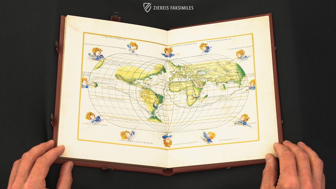
World Map
This famous chart is a gorgeously designed world map that depicts the route taken by Magellan during the first successful circumnavigation of the globe in the years 1519–21. While this route is drawn in black, another is drawn with gold ink because it connects Spain to the goldmines of Peru. In the Pacific Ocean, Baja California is correctly presented as a peninsula unlike 60 years later when cartographers began to depict it as an island.
The map is rendered in an oval projection resembling a modern map, but this fine watercolor was intended for display in the homes of the wealthy and educated rather than see use as a practical tool for sailors at sea. The Anemoi, ancient Greek wind gods who were each ascribed a cardinal direction from which their respective winds came, frame the map with their curly blonde hair blowing in the wind.
")
#1 Atlante Nautico di Battista Agnese
Language: Italian
(1,000€ - 3,000€)
")
 – National Library of Russia (St. Petersburg, Russia)")
")
")
")
")

- Treatises / Secular Books
- Apocalypses / Beatus
- Astronomy / Astrology
- Bestiaries
- Bibles / Gospels
- Chronicles / History / Law
- Geography / Maps
- Saints' Lives
- Islam / Oriental
- Judaism / Hebrew
- Single Leaf Collections
- Leonardo da Vinci
- Literature / Poetry
- Liturgical Manuscripts
- Medicine / Botany / Alchemy
- Music
- Mythology / Prophecies
- Psalters
- Other Religious Books
- Games / Hunting
- Private Devotion Books
- Other Genres
- Afghanistan
- Armenia
- Austria
- Belgium
- Belize
- Bosnia and Herzegovina
- China
- Colombia
- Costa Rica
- Croatia
- Cyprus
- Czech Republic
- Denmark
- Egypt
- El Salvador
- Ethiopia
- France
- Germany
- Greece
- Guatemala
- Honduras
- Hungary
- India
- Iran
- Iraq
- Israel
- Italy
- Japan
- Jordan
- Kazakhstan
- Kyrgyzstan
- Lebanon
- Liechtenstein
- Luxembourg
- Mexico
- Morocco
- Netherlands
- Palestine
- Panama
- Peru
- Poland
- Portugal
- Romania
- Russia
- Serbia
- Spain
- Sri Lanka
- Sweden
- Switzerland
- Syria
- Tajikistan
- Turkey
- Turkmenistan
- Ukraine
- United Kingdom
- United States
- Uzbekistan
- Vatican City
- A. Oosthoek, van Holkema & Warendorf
- Aboca Museum
- Ajuntament de Valencia
- Akademie Verlag
- Akademische Druck- u. Verlagsanstalt (ADEVA)
- Aldo Ausilio Editore - Bottega d’Erasmo
- Alecto Historical Editions
- Alkuin Verlag
- Almqvist & Wiksell
- Amilcare Pizzi
- Andreas & Andreas Verlagsbuchhandlung
- Archa 90
- Archiv Verlag
- Archivi Edizioni
- Arnold Verlag
- ARS
- Ars Magna
- Ars Millenii
- Art Market
- ArtCodex
- AyN Ediciones
- Azimuth Editions
- Badenia Verlag
- Bärenreiter-Verlag
- Belser Verlag
- Belser Verlag / WK Wertkontor
- Benziger Verlag
- Bernardinum Wydawnictwo
- BiblioGemma
- Biblioteca Apostolica Vaticana (Vaticanstadt, Vaticanstadt)
- Bibliotheca Palatina Faksimile Verlag
- Bibliotheca Rara
- Boydell & Brewer
- Bramante Edizioni
- Bredius Genootschap
- Brepols Publishers
- British Library
- Brokarte
- C. Weckesser
- Caixa Catalunya
- Canesi
- CAPSA, Ars Scriptoria
- Caratzas Brothers, Publishers
- Carus Verlag
- Casamassima Libri
- Centrum Cartographie Verlag GmbH
- Chavane Verlag
- Christian Brandstätter Verlag
- Circulo Cientifico
- Club Bibliófilo Versol
- Club du Livre
- Club Internacional del Libro
- CM Editores
- Collegium Graphicum
- Collezione Apocrifa Da Vinci
- Comissão Nacional para as Comemorações dos Descobrimentos Portugueses
- Coron Verlag
- Corvina
- CTHS
- D. S. Brewer
- Damon
- De Agostini/UTET
- De Nederlandsche Boekhandel
- De Schutter
- Deuschle & Stemmle
- Deutscher Verlag für Kunstwissenschaft
- DIAMM
- Dropmore Press
- Droz
- E. Schreiber Graphische Kunstanstalten
- Ediciones Boreal
- Ediciones Grial
- Ediclube
- Edições Inapa
- Edilan
- Editalia
- Edition Deuschle
- Edition Georg Popp
- Edition Leipzig
- Edition Libri Illustri
- Editiones Reales Sitios S. L.
- Éditions de l'Oiseau Lyre
- Editions Medicina Rara
- Editorial Casariego
- Editorial Mintzoa
- Editrice Antenore
- Editrice Velar
- Edizioni Edison
- Egeria, S.L.
- Eikon Editores
- Electa
- Emery Walker Limited
- Enciclopèdia Catalana
- Eos-Verlag
- Ephesus Publishing
- Ernst Battenberg
- Eugrammia Press
- Extraordinary Editions
- Fackelverlag
- Facsimila Art & Edition
- Facsimile Editions Ltd.
- Facsimilia Art & Edition Ebert KG
- Faksimile Verlag
- Feuermann Verlag
- Folger Shakespeare Library
- Franco Cosimo Panini Editore
- Friedrich Wittig Verlag
- Fundación Hullera Vasco-Leonesa
- G. Braziller
- Gabriele Mazzotta Editore
- Gebr. Mann Verlag
- Gesellschaft für graphische Industrie
- Getty Research Institute
- Giovanni Domenico de Rossi
- Giunti Editore
- Goldenmark Librarium
- Graffiti
- Grafica European Center of Fine Arts
- Guido Pressler
- Guillermo Blazquez
- Gustav Kiepenheuer
- H. N. Abrams
- Harrassowitz
- Harvard University Press
- Helikon
- Hendrickson Publishers
- Henning Oppermann
- Herder Verlag
- Hes & De Graaf Publishers
- Hoepli
- Holbein-Verlag
- Houghton Library
- Hugo Schmidt Verlag
- Hungarian Academy of Sciences
- Idion Verlag
- Il Bulino, edizioni d'arte
- ILte
- Imago
- Insel Verlag
- Insel-Verlag Anton Kippenberger
- Instituto de Estudios Altoaragoneses
- Instituto Nacional de Antropología e Historia
- Introligatornia Budnik Jerzy
- Istituto dell'Enciclopedia Italiana - Treccani
- Istituto Ellenico di Studi Bizantini e Postbizantini
- Istituto Geografico De Agostini
- Istituto Poligrafico e Zecca dello Stato
- Italarte Art Establishments
- Jaca Book
- Jan Thorbecke Verlag
- Johnson Reprint Corporation
- Johnson Reprint Corporation
- Jos. Baer
- Josef Stocker
- Josef Stocker-Schmid
- Jugoslavija
- Karl W. Hiersemann
- Kasper Straube
- Kaydeda Ediciones
- Kindler Verlag / Coron Verlag
- Kodansha International Ltd.
- Konrad Kölbl Verlag
- Kurt Wolff Verlag
- La Liberia dello Stato
- La Linea Editrice
- La Meta Editore
- Lambert Schneider
- Landeskreditbank Baden-Württemberg
- Leo S. Olschki
- Les Incunables
- Liber Artis
- Library of Congress
- Libreria Musicale Italiana
- Lichtdruck
- Lito Immagine Editore
- Lumen Artis
- Lund Humphries
- M. Moleiro Editor
- Maison des Sciences de l'homme et de la société de Poitiers
- Manuscriptum
- Martinus Nijhoff
- Maruzen-Yushodo Co. Ltd.
- MASA
- Massada Publishers
- McGraw-Hill
- Metropolitan Museum of Art
- Militos
- Millennium Liber
- Müller & Schindler
- Nahar - Stavit
- Nahar and Steimatzky
- National Library of Wales
- Neri Pozza
- Nova Charta
- Oceanum Verlag
- Odeon
- Omnia Arte
- Orbis Mediaevalis
- Orbis Pictus
- Österreichische Staatsdruckerei
- Oxford University Press
- Pageant Books
- Parzellers Buchverlag
- Patrimonio Ediciones
- Pattloch Verlag
- PIAF
- Pieper Verlag
- Plon-Nourrit et cie
- Poligrafiche Bolis
- Presses Universitaires de Strasbourg
- Prestel Verlag
- Princeton University Press
- Prisma Verlag
- Priuli & Verlucca, editori
- Pro Sport Verlag
- Propyläen Verlag
- Pytheas Books
- Quaternio Verlag Luzern
- Reales Sitios
- Recht-Verlag
- Reichert Verlag
- Reichsdruckerei
- Reprint Verlag
- Riehn & Reusch
- Roberto Vattori Editore
- Rosenkilde and Bagger
- Roxburghe Club
- Salerno Editrice
- Saltellus Press
- Sandoz
- Sarajevo Svjetlost
- Schöck ArtPrint Kft.
- Schulsinger Brothers
- Scolar Press
- Scrinium
- Scripta Maneant
- Scriptorium
- Shazar
- Siloé, arte y bibliofilia
- SISMEL - Edizioni del Galluzzo
- Sociedad Mexicana de Antropología
- Société des Bibliophiles & Iconophiles de Belgique
- Soncin Publishing
- Sorli Ediciones
- Stainer and Bell
- Studer
- Styria Verlag
- Sumptibus Pragopress
- Szegedi Tudomànyegyetem
- Taberna Libraria
- Tarshish Books
- Taschen
- Tempus Libri
- Testimonio Compañía Editorial
- TGB Limited Editions
- Thames and Hudson
- The Clear Vue Publishing Partnership Limited
- The Facsimile Codex
- The Folio Society
- The Marquess of Normanby
- The Orphan Hospital Ward of Israel
- The Richard III and Yorkist History Trust
- The Warburg Institute
- Tip.Le.Co
- TouchArt
- TREC Publishing House
- TRI Publishing Co.
- Trident Editore
- Tuliba Collection
- Typis Regiae Officinae Polygraphicae
- Union Verlag Berlin
- Universidad de Granada
- Universitaire Bibliotheken Leiden
- University of California Press
- University of Chicago Press
- Urs Graf
- Vallecchi
- Van Wijnen
- VCH, Acta Humaniora
- VDI Verlag
- VEB Deutscher Verlag für Musik
- Verein Schweizerischer Lithographie-Besitzer
- Verlag Anton Pustet / Andreas Verlag
- Verlag Bibliophile Drucke Josef Stocker
- Verlag der Münchner Drucke
- Verlag für Regionalgeschichte
- Verlag Styria
- Vicent Garcia Editores
- W. Turnowsky
- Waanders Printers
- Wiener Mechitharisten-Congregation (Wien, Österreich)
- Wissenschaftliche Buchgesellschaft
- Wissenschaftliche Verlagsgesellschaft
- Wydawnictwo Dolnoslaskie
- Xuntanza Editorial
- Zakład Narodowy
- Zollikofer AG