Charles V Atlas & Magellan Atlas
 / Biblioteca Nacional de España (Madrid, Spain)")
Italy — 16th century
The impressive testimony of the fruitful collaboration between two geniuses of their art: two geographical masterpieces for Emperor Charles V designed by Battista Agnese and illuminated by Guilio Clovio
Commissioned by the Emperor, the Charles V Atlas was a gift to the future Spanish King Philip II (1527–98)
Created in Venice by the famous cartographer Battista Agnese and decorated by Giulio Clovio
The Magellan Atlas, also commissioned by Charles V (1500–58), documents the voyage of Ferdinand Magellan
Charles V Atlas & Magellan Atlas

 / Biblioteca Nacional de España (Madrid, Spain)")
 / Biblioteca Nacional de España (Madrid, Spain)")
 / Biblioteca Nacional de España (Madrid, Spain)")
 / Biblioteca Nacional de España (Madrid, Spain)")
 / Biblioteca Nacional de España (Madrid, Spain)")
 / Biblioteca Nacional de España (Madrid, Spain)")
 / Biblioteca Nacional de España (Madrid, Spain)")
 / Biblioteca Nacional de España (Madrid, Spain)")
 / Biblioteca Nacional de España (Madrid, Spain)")
 / Biblioteca Nacional de España (Madrid, Spain)")
 / Biblioteca Nacional de España (Madrid, Spain)")
 / Biblioteca Nacional de España (Madrid, Spain)")
 / Biblioteca Nacional de España (Madrid, Spain)")
 / Biblioteca Nacional de España (Madrid, Spain)")
 / Biblioteca Nacional de España (Madrid, Spain)")
 / Biblioteca Nacional de España (Madrid, Spain)")
 / Biblioteca Nacional de España (Madrid, Spain)")
 / Biblioteca Nacional de España (Madrid, Spain)")
 / Biblioteca Nacional de España (Madrid, Spain)")
 / Biblioteca Nacional de España (Madrid, Spain)")
 / Biblioteca Nacional de España (Madrid, Spain)")
 / Biblioteca Nacional de España (Madrid, Spain)")
 / Biblioteca Nacional de España (Madrid, Spain)")
 / Biblioteca Nacional de España (Madrid, Spain)")
 / Biblioteca Nacional de España (Madrid, Spain)")
 / Biblioteca Nacional de España (Madrid, Spain)")
 / Biblioteca Nacional de España (Madrid, Spain)")
 / Biblioteca Nacional de España (Madrid, Spain)")
 / Biblioteca Nacional de España (Madrid, Spain)")
 / Biblioteca Nacional de España (Madrid, Spain)")
 / Biblioteca Nacional de España (Madrid, Spain)")
(3,000€ - 7,000€)
The compendium of two important atlases of the 16th century offers insight into the glory of the geographical implements that were available during the Renaissance. The Atlas of Charles V was produced in 1542 in Venice by the famous cartographer Battista Agnese with the book’s decoration being rounded out by Guilio Clovio. The Atlas of Magellan tells the story of the first circumnavigation of the world through the Portuguese, who were commissioned by the Spanish King Charles I (later Emperor Charles V). Important names are connected to this prominent and artistically impressive work of cartography.
Charles V Atlas & Magellan Atlas
The compendium of two important atlases of the 16th century offers insight into the glory of the geographical implements that were available during the Renaissance. The Atlas of Charles V was produced in 1542 in Venice by the famous cartographer Battista Agnese with the book’s decoration being rounded out by Guilio Clovio. The Atlas of Magellan tells the story of the first circumnavigation of the world through the Portuguese, who were commissioned by the Spanish King Charles I (later Emperor Charles V). Important names are connected to this prominent and artistically impressive work of cartography.
Cartography of the Renaissance
Through the 32 to 35 pages of the maps of the atlases, a view of the world of the middle of the 16th century is apparent. In this time, the great discoveries steadily changed the map of the world. Yet the newly discovered continents rendered the maps ever more concrete and truer to reality. Charles V, the Holy Roman Emperor, commissioned in 1542 the creation of an atlas, which would serve as a luxurious auxiliary tool for the geographic education of his son, Philip. The future Spanish King Philip II received the atlas as a 16th birthday present. For the cartographer, Charles V chose the Genoese Battista Agnese, who was one of the greatest of his guild. With his body of work comprising of more than 100 atlases, his knowledge and skill spoke for itself. He was employed in Venice, where he finished his cartographic works for the European Royal Houses and other important patrons. The atlas for Emperor Charles V contains a multitude of different maps: more detailed maps of specific continents, for example the Italian boot or the Baja California, with numerous legends and geographical data. Furthermore, there are different large scale world maps, a map of the stars, and a depiction of an armillary sphere.
An Atlas as a Work of Art
All of these geographically exact representations are imbedded in a large framework of magnificent borders. The frames are imbedded with ornamental representations of plants, masks, and mythical creatures. They show scenic representations and portraits, which appear to be partly in the style of antiquity. For example, depictions of knights are painted in the fashion of a Greek vase. In the entire splendor, there are mottos, Coats of Arms, and the already mentioned portraits integrated in the style of medallions from antiquity. All told, the significant influence of the Renaissance is recognizable. The artist of the design of the maps—which is partly even decorated with rich gold—was the Italian Guilio Clovio. With this main work, the Book of Hours of Cardinal Alessandro Farnese, Clovio was the most famous manuscript artist of the Italian Renaissance.
The history of the First Global Circumnavigation
The second Atlas, originating in 1544, is so-named as the Magellan Atlas. It contains maps in relation to Ferdinand Magellan (1480–1521) and his first circumnavigation of the world. In the service of the Spanish King Charles I, later Emperor Charles V, the Portuguese navigator sailed West on September 20th, 1519 with a fleet of five ships, in order to find the so-called Western Passage to the Pacific Ocean. The enterprise was successful—the so-called Strait of Magellan was even named after him. Yet he died on the trip home in the Philippines. The maps in this atlas are likewise detailed as the Charles V Atlas. They contain exact data specific to the oceans and seas, because they mainly were meant to serve seafaring ventures.
Codicology
- Alternative Titles
- Colección: Atlas de Carlos V y Atlas de Magallanes
Set of Atlases: the Charles V and Magellan Atlases
Der Atlas Karls V. und der Atlas Magellans
Collection: Atlas de Charles Quint et Atlas de Magellan
Collezione Atlante di Carlo V e Atlante di Magellano
Colecção Atlas de Carlos V e Atlas de Magalhães - Type
- Maps on parchment
- Size / Format
- 32 pages 36 pages / 22.0 × 15.0 cm 20.0 × 14.0 cm
- Origin
- Italy
- Date
- 16th century
- Epochs
- Style
- Genre
- Language
- Script
- Gothic Textura Quadrata
- Illustrations
- Atlas of Charles V: artful gold-adorned maps in frames as opulent as they are fanciful
Magellan Atlas: detailed map works adorned with gold and silver with some ornate illustrations - Content
- Two luxury atlases depicting various regions of the world by Battissta Agnese
- Patron
- Charles V, Holy Roman Emperor and King of Spain (1500-58) or possibly Martin of Aragon (1525-81)
- Artist / School
- Batista Agnese (ca. 1500–64) (cartographer)
Giulio Clovio (1498–1578) (illuminator) - Previous Owners
- King Philip II of Spain (1527 – 1598)
 / Biblioteca Nacional de España (Madrid, Spain)")
Charles V Atlas
The New World
This portolan chart depicts Central America and the neighboring regions with particularly important and valuable Caribbean islands like Cuba and Hispaniola outlined with gold ink. In the Pacific Ocean, Baja California is correctly depicted as a peninsula. 60 years later, cartographers began to depict it as an island, but this manuscript was a gift from Charles to his son Philip II, who would inherit his father’s overseas empire, and so this map was created with special care and attention to detail.
 / Biblioteca Nacional de España (Madrid, Spain)")
Charles V Atlas & Magellan Atlas
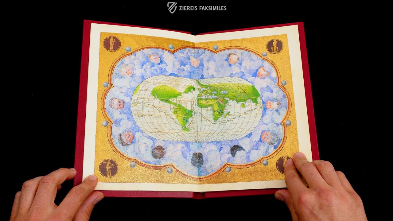
The Northern Hemisphere
This unusual map is oriented with West at the top and the Arctic Circle at the center, giving us a top-down view of the globe. North America is not recognizable to modern eyes because most of it had yet to be explored, which was also true of East Asia. The long sought-after Northwest Passage is missing, and instead Asia and Europe are depicted connected to North America.
The map was created using a bright color palette and gold ink with Europe given a special red-orange color to distinguish it from the rest of the Old World. Four of the Anemoi, the wind gods who are each ascribed a cardinal direction, surround the red frame, which has four different patterns in gold four each of the four quarters of the Northern Hemisphere.
 / Biblioteca Nacional de España (Madrid, Spain)")
#1 Colección: Atlas de Carlos V y Atlas de Magallanes
Language: English, Spanish, German, Italian
(3,000€ - 7,000€)
 – National Library of Russia (St. Petersburg, Russia)")
")
")
")
")
- Treatises / Secular Books
- Apocalypses / Beatus
- Astronomy / Astrology
- Bestiaries
- Bibles / Gospels
- Chronicles / History / Law
- Geography / Maps
- Saints' Lives
- Islam / Oriental
- Judaism / Hebrew
- Single Leaf Collections
- Leonardo da Vinci
- Literature / Poetry
- Liturgical Manuscripts
- Medicine / Botany / Alchemy
- Music
- Mythology / Prophecies
- Psalters
- Other Religious Books
- Games / Hunting
- Private Devotion Books
- Other Genres
- Afghanistan
- Armenia
- Austria
- Belgium
- Belize
- Bosnia and Herzegovina
- China
- Colombia
- Costa Rica
- Croatia
- Cyprus
- Czech Republic
- Denmark
- Egypt
- El Salvador
- Ethiopia
- France
- Germany
- Greece
- Guatemala
- Honduras
- Hungary
- India
- Iran
- Iraq
- Israel
- Italy
- Japan
- Jordan
- Kazakhstan
- Kyrgyzstan
- Lebanon
- Liechtenstein
- Luxembourg
- Mexico
- Morocco
- Netherlands
- Palestine
- Panama
- Peru
- Poland
- Portugal
- Romania
- Russia
- Serbia
- Spain
- Sri Lanka
- Sweden
- Switzerland
- Syria
- Tajikistan
- Turkey
- Turkmenistan
- Ukraine
- United Kingdom
- United States
- Uzbekistan
- Vatican City
- A. Oosthoek, van Holkema & Warendorf
- Aboca Museum
- Ajuntament de Valencia
- Akademie Verlag
- Akademische Druck- u. Verlagsanstalt (ADEVA)
- Aldo Ausilio Editore - Bottega d’Erasmo
- Alecto Historical Editions
- Alkuin Verlag
- Almqvist & Wiksell
- Amilcare Pizzi
- Andreas & Andreas Verlagsbuchhandlung
- Archa 90
- Archiv Verlag
- Archivi Edizioni
- Arnold Verlag
- ARS
- Ars Magna
- ArtCodex
- AyN Ediciones
- Azimuth Editions
- Badenia Verlag
- Bärenreiter-Verlag
- Belser Verlag
- Belser Verlag / WK Wertkontor
- Benziger Verlag
- Bernardinum Wydawnictwo
- BiblioGemma
- Biblioteca Apostolica Vaticana (Vaticanstadt, Vaticanstadt)
- Bibliotheca Palatina Faksimile Verlag
- Bibliotheca Rara
- Boydell & Brewer
- Bramante Edizioni
- Bredius Genootschap
- Brepols Publishers
- British Library
- C. Weckesser
- Caixa Catalunya
- Canesi
- CAPSA, Ars Scriptoria
- Caratzas Brothers, Publishers
- Carus Verlag
- Casamassima Libri
- Centrum Cartographie Verlag GmbH
- Chavane Verlag
- Christian Brandstätter Verlag
- Circulo Cientifico
- Club Bibliófilo Versol
- Club du Livre
- CM Editores
- Collegium Graphicum
- Collezione Apocrifa Da Vinci
- Comissão Nacional para as Comemorações dos Descobrimentos Portugueses
- Coron Verlag
- Corvina
- CTHS
- D. S. Brewer
- Damon
- De Agostini/UTET
- De Nederlandsche Boekhandel
- De Schutter
- Deuschle & Stemmle
- Deutscher Verlag für Kunstwissenschaft
- DIAMM
- Droz
- E. Schreiber Graphische Kunstanstalten
- Ediciones Boreal
- Ediciones Grial
- Ediclube
- Edições Inapa
- Edilan
- Editalia
- Edition Deuschle
- Edition Georg Popp
- Edition Leipzig
- Edition Libri Illustri
- Editiones Reales Sitios S. L.
- Éditions de l'Oiseau Lyre
- Editions Medicina Rara
- Editorial Casariego
- Editorial Mintzoa
- Editrice Antenore
- Editrice Velar
- Edizioni Edison
- Egeria, S.L.
- Eikon Editores
- Electa
- Emery Walker Limited
- Enciclopèdia Catalana
- Eos-Verlag
- Ephesus Publishing
- Ernst Battenberg
- Eugrammia Press
- Extraordinary Editions
- Fackelverlag
- Facsimila Art & Edition
- Facsimile Editions Ltd.
- Facsimilia Art & Edition Ebert KG
- Faksimile Verlag
- Feuermann Verlag
- Folger Shakespeare Library
- Franco Cosimo Panini Editore
- Friedrich Wittig Verlag
- Fundación Hullera Vasco-Leonesa
- G. Braziller
- Gabriele Mazzotta Editore
- Gebr. Mann Verlag
- Gesellschaft für graphische Industrie
- Getty Research Institute
- Giovanni Domenico de Rossi
- Giunti Editore
- Graffiti
- Grafica European Center of Fine Arts
- Guido Pressler
- Guillermo Blazquez
- Gustav Kiepenheuer
- H. N. Abrams
- Harrassowitz
- Harvard University Press
- Helikon
- Hendrickson Publishers
- Henning Oppermann
- Herder Verlag
- Hes & De Graaf Publishers
- Hoepli
- Holbein-Verlag
- Houghton Library
- Hugo Schmidt Verlag
- Idion Verlag
- Il Bulino, edizioni d'arte
- ILte
- Imago
- Insel Verlag
- Insel-Verlag Anton Kippenberger
- Instituto de Estudios Altoaragoneses
- Instituto Nacional de Antropología e Historia
- Introligatornia Budnik Jerzy
- Istituto dell'Enciclopedia Italiana - Treccani
- Istituto Ellenico di Studi Bizantini e Postbizantini
- Istituto Geografico De Agostini
- Istituto Poligrafico e Zecca dello Stato
- Italarte Art Establishments
- Jan Thorbecke Verlag
- Johnson Reprint Corporation
- Josef Stocker
- Josef Stocker-Schmid
- Jugoslavija
- Karl W. Hiersemann
- Kasper Straube
- Kaydeda Ediciones
- Kindler Verlag / Coron Verlag
- Kodansha International Ltd.
- Konrad Kölbl Verlag
- Kurt Wolff Verlag
- La Liberia dello Stato
- La Linea Editrice
- La Meta Editore
- Lambert Schneider
- Landeskreditbank Baden-Württemberg
- Leo S. Olschki
- Les Incunables
- Liber Artis
- Library of Congress
- Libreria Musicale Italiana
- Lichtdruck
- Lito Immagine Editore
- Lumen Artis
- Lund Humphries
- M. Moleiro Editor
- Maison des Sciences de l'homme et de la société de Poitiers
- Manuscriptum
- Martinus Nijhoff
- Maruzen-Yushodo Co. Ltd.
- MASA
- Massada Publishers
- McGraw-Hill
- Metropolitan Museum of Art
- Militos
- Millennium Liber
- Müller & Schindler
- Nahar - Stavit
- Nahar and Steimatzky
- National Library of Wales
- Neri Pozza
- Nova Charta
- Oceanum Verlag
- Odeon
- Orbis Mediaevalis
- Orbis Pictus
- Österreichische Staatsdruckerei
- Oxford University Press
- Pageant Books
- Parzellers Buchverlag
- Patrimonio Ediciones
- Pattloch Verlag
- PIAF
- Pieper Verlag
- Plon-Nourrit et cie
- Poligrafiche Bolis
- Presses Universitaires de Strasbourg
- Prestel Verlag
- Princeton University Press
- Prisma Verlag
- Priuli & Verlucca, editori
- Pro Sport Verlag
- Propyläen Verlag
- Pytheas Books
- Quaternio Verlag Luzern
- Reales Sitios
- Recht-Verlag
- Reichert Verlag
- Reichsdruckerei
- Reprint Verlag
- Riehn & Reusch
- Roberto Vattori Editore
- Rosenkilde and Bagger
- Roxburghe Club
- Salerno Editrice
- Saltellus Press
- Sandoz
- Sarajevo Svjetlost
- Schöck ArtPrint Kft.
- Schulsinger Brothers
- Scolar Press
- Scrinium
- Scripta Maneant
- Scriptorium
- Shazar
- Siloé, arte y bibliofilia
- SISMEL - Edizioni del Galluzzo
- Sociedad Mexicana de Antropología
- Société des Bibliophiles & Iconophiles de Belgique
- Soncin Publishing
- Sorli Ediciones
- Stainer and Bell
- Studer
- Styria Verlag
- Sumptibus Pragopress
- Szegedi Tudomànyegyetem
- Taberna Libraria
- Tarshish Books
- Taschen
- Tempus Libri
- Testimonio Compañía Editorial
- Thames and Hudson
- The Clear Vue Publishing Partnership Limited
- The Facsimile Codex
- The Folio Society
- The Marquess of Normanby
- The Richard III and Yorkist History Trust
- Tip.Le.Co
- TouchArt
- TREC Publishing House
- TRI Publishing Co.
- Trident Editore
- Tuliba Collection
- Typis Regiae Officinae Polygraphicae
- Union Verlag Berlin
- Universidad de Granada
- University of California Press
- University of Chicago Press
- Urs Graf
- Vallecchi
- Van Wijnen
- VCH, Acta Humaniora
- VDI Verlag
- VEB Deutscher Verlag für Musik
- Verlag Anton Pustet / Andreas Verlag
- Verlag Bibliophile Drucke Josef Stocker
- Verlag der Münchner Drucke
- Verlag für Regionalgeschichte
- Verlag Styria
- Vicent Garcia Editores
- W. Turnowski Ltd.
- W. Turnowsky
- Waanders Printers
- Wiener Mechitharisten-Congregation (Wien, Österreich)
- Wissenschaftliche Buchgesellschaft
- Wissenschaftliche Verlagsgesellschaft
- Wydawnictwo Dolnoslaskie
- Xuntanza Editorial
- Zakład Narodowy
- Zollikofer AG