Atlas of the Worlds
")
Venice (Italy) — Ca. 1540
From the workshop of Battista Agnese, arguably the most talented cartographer of the 16th century: scientific accuracy and the refined artistry of the Italian Renaissance combined in a delicately adorned masterpiece
Battista Agnese (ca. 1500–1564) produced more than 80 atlases over the course of 30 years in Venice
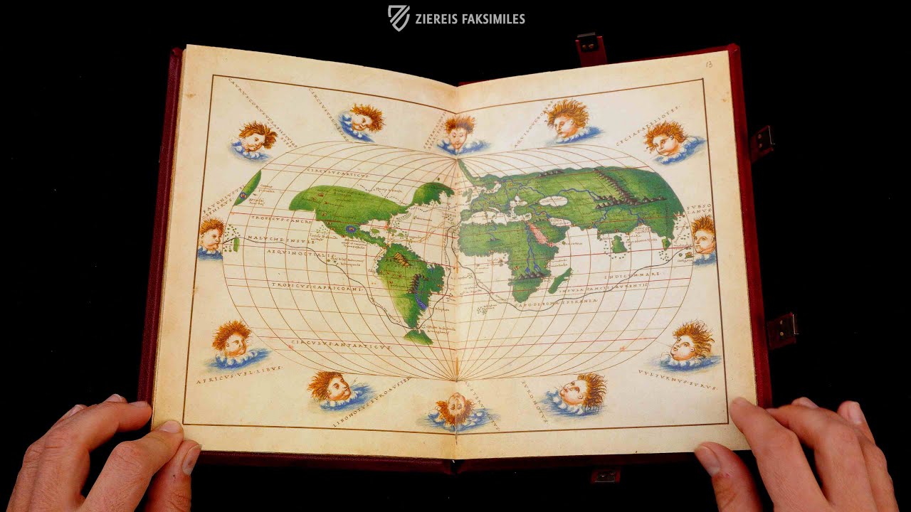
This manuscript consists of 9 nautical charts, 1 world map surrounded by 12 blowing Anemoi, and 1 zodiac chart
Since the Baja California Peninsula is not depicted, it must have been created between 1536 and 1541
Atlas of the Worlds

")
")
")
")
")
")
")
")
")
")
")
")
")
")
")
")
")
")
")
")
")
")
")
")
")
(1,000€ - 3,000€)
Battista Agnese was one of the most talented and prolific Italian cartographers of the 16th century, producing more than 80 atlases over the course of 30 years, each consisting of richly decorated and precise nautical charts for wealthy nobles, merchants, and officials. This work was commissioned by the Martinengo family, nobles from Brescia with strong ties to Venice. It comprises nine nautical charts, a world map surrounded by twelve blowing Anemoi, and a zodiac chart, all richly colored in black, blue, gold, red, and green. The place names are rendered in Latin, Venetian, Castilian, and Portuguese. Since the Baja California Peninsula is not depicted, this otherwise undated manuscript can be dated to between 1536 and 1541. The precision with which the land route across the Isthmus of Panama to Upper Peru is depicted reflects the importance of Peruvian mineral resources for the Republic of Venice. Thus, this precious manuscript combines a scientific degree of accuracy with the refined artistry of the Italian Renaissance.
Atlas of the Worlds
For centuries, cartographic works were among the most valuable and expensive possessions of wealthy families. Not only was their content particularly valuable, it was also the extraordinary art of their production that made them so coveted. Often magnificently decorated, their appearance alone bore witness to this luxury. One of these fascinating works of art is the Atlas of the Worlds from the workshop of Battista Agnese (ca. 1500–1564). It is an outstanding testimony to this appreciation and is associated with the influential Martinengo family clan.
A Status Symbol for a Powerful Renaissance Family
The Martinengos were one of the most powerful families in 16th century Brescia. While the city was under the rule of the Republic of Venice, the family gained a reputation for constantly supplying the Venetian army with condottieri and infantry captains from their own ranks. A member of this important family commissioned the Atlas of the Worlds and thus acquired a splendid status symbol.
A masterpiece by Battista Agnese
The work was created in the famous Venetian workshop of Battista Agnese. The cartographer from Genoa is regarded as one of the most accomplished and productive cartographers of the 16th century and was responsible for dozens of high-quality cartographic works. As in Agnese's other works, cosmographic and cartographic images are the primary language of the atlas, which also incorporates contemporary geographical knowledge of the time – such as the Isthmus from Panama to Peru. Its depiction is also a remarkable historical testimony to the importance of Peruvian mineral resources and their trade for the Republic of Venice.
Gold-decorated Maps
The ornate atlas begins with a golden diagram of the twelve zodiac signs, which catch the eye in dark blue. It is followed by nine nautical charts, first showing the Pacific, Atlantic and Indian Oceans, followed by maps of the coastlines of the British Isles and the Iberian Peninsula. A central component are the three impressively accurate nautical charts of the Mediterranean, followed by a depiction of the Black Sea. The work concludes with Agnese's famous world map in oval projection, decorated at the edges with the twelve classical compass winds in the form of putti, depicted with their names in Latin and Greek. All the maps are in a delicate golden frame and have been artfully created with vibrant colors. A true masterpiece of cartography!
Codicology
- Alternative Titles
- Atlas der zwei Welten
Atlante dei Mondi - Type
- Map on parchment
- Size / Format
- 26 pages / 23.8 × 16.5 cm
- Origin
- Italy
- Date
- Ca. 1540
- Epochs
- Style
- Genre
- Language
- Illustrations
- 13 finely crafted, double-page maps in bright colors
- Content
- 9 nautical charts, 1 world map and 1 zodiac chart
- Patron
- Martinengo family
- Artist / School
- Workshop of Battista Agnese (cartographer)
")
Atlas of the Worlds
The British Isles
No matter how detailed maps originating from the great cartographic centers of the Mediterranean were in their depictions of familiar shores, they usually have very vague depictions of the British Isles save for its most southernly coasts. Aside from giving a relatively accurate representation of the coastlines of England, Scotland, and Ireland, this map labels some of the more important of the smaller islands such as the Isle of Mann, but the distant Shetland Islands in the North Sea are merely a bunch of red dots.
")
Atlas of the Worlds
World Map
This is an early draft of one of the most popular and copied world maps and is significant for three reasons: it represents the most current geographic knowledge of European cartographers ca. 1540, it is rendered in an oval projection resembling a modern map, and it depicts the sea route chosen by Magellan for his circumnavigation of the globe.
Rather than being a practical aid for navigators, this watercolor was intended for display in the homes of the wealthy and educated and thus includes artistic details impractical for navigation. It is surprisingly accurate and can be dated between 1536 and 1541 because the Baja California Peninsula is not depicted. The Anemoi, ancient Greek wind gods who were each ascribed a cardinal direction from which their respective winds came, frame the map.
")
#1 Atlante dei Mondi
Language: German
(1,000€ - 3,000€)
")
 – National Library of Russia (St. Petersburg, Russia)")
")
")
")
")
- Treatises / Secular Books
- Apocalypses / Beatus
- Astronomy / Astrology
- Bestiaries
- Bibles / Gospels
- Chronicles / History / Law
- Geography / Maps
- Saints' Lives
- Islam / Oriental
- Judaism / Hebrew
- Single Leaf Collections
- Leonardo da Vinci
- Literature / Poetry
- Liturgical Manuscripts
- Medicine / Botany / Alchemy
- Music
- Mythology / Prophecies
- Psalters
- Other Religious Books
- Games / Hunting
- Private Devotion Books
- Other Genres
- Afghanistan
- Armenia
- Austria
- Belgium
- Belize
- Bosnia and Herzegovina
- China
- Colombia
- Costa Rica
- Croatia
- Cyprus
- Czech Republic
- Denmark
- Egypt
- El Salvador
- Ethiopia
- France
- Germany
- Greece
- Guatemala
- Honduras
- Hungary
- India
- Iran
- Iraq
- Israel
- Italy
- Japan
- Jordan
- Kazakhstan
- Kyrgyzstan
- Lebanon
- Liechtenstein
- Luxembourg
- Mexico
- Morocco
- Netherlands
- Palestine
- Panama
- Peru
- Poland
- Portugal
- Romania
- Russia
- Serbia
- Spain
- Sri Lanka
- Sweden
- Switzerland
- Syria
- Tajikistan
- Turkey
- Turkmenistan
- Ukraine
- United Kingdom
- United States
- Uzbekistan
- Vatican City
- A. Oosthoek, van Holkema & Warendorf
- Aboca Museum
- Ajuntament de Valencia
- Akademie Verlag
- Akademische Druck- u. Verlagsanstalt (ADEVA)
- Aldo Ausilio Editore - Bottega d’Erasmo
- Alecto Historical Editions
- Alkuin Verlag
- Almqvist & Wiksell
- Amilcare Pizzi
- Andreas & Andreas Verlagsbuchhandlung
- Archa 90
- Archiv Verlag
- Archivi Edizioni
- Arnold Verlag
- ARS
- Ars Magna
- Ars Millenii
- Art Market
- ArtCodex
- AyN Ediciones
- Azimuth Editions
- Badenia Verlag
- Bärenreiter-Verlag
- Belser Verlag
- Belser Verlag / WK Wertkontor
- Benziger Verlag
- Bernardinum Wydawnictwo
- BiblioGemma
- Biblioteca Apostolica Vaticana (Vaticanstadt, Vaticanstadt)
- Bibliotheca Palatina Faksimile Verlag
- Bibliotheca Rara
- Boydell & Brewer
- Bramante Edizioni
- Bredius Genootschap
- Brepols Publishers
- British Library
- Brokarte
- C. Weckesser
- Caixa Catalunya
- Canesi
- CAPSA, Ars Scriptoria
- Caratzas Brothers, Publishers
- Carus Verlag
- Casamassima Libri
- Centrum Cartographie Verlag GmbH
- Chavane Verlag
- Christian Brandstätter Verlag
- Circulo Cientifico
- Club Bibliófilo Versol
- Club du Livre
- Club Internacional del Libro
- CM Editores
- Collegium Graphicum
- Collezione Apocrifa Da Vinci
- Comissão Nacional para as Comemorações dos Descobrimentos Portugueses
- Coron Verlag
- Corvina
- CTHS
- D. S. Brewer
- Damon
- De Agostini/UTET
- De Nederlandsche Boekhandel
- De Schutter
- Deuschle & Stemmle
- Deutscher Verlag für Kunstwissenschaft
- DIAMM
- Dropmore Press
- Droz
- E. Schreiber Graphische Kunstanstalten
- Ediciones Boreal
- Ediciones Grial
- Ediclube
- Edições Inapa
- Edilan
- Editalia
- Edition Deuschle
- Edition Georg Popp
- Edition Leipzig
- Edition Libri Illustri
- Editiones Reales Sitios S. L.
- Éditions de l'Oiseau Lyre
- Editions Medicina Rara
- Editorial Casariego
- Editorial Mintzoa
- Editrice Antenore
- Editrice Velar
- Edizioni Edison
- Egeria, S.L.
- Eikon Editores
- Electa
- Emery Walker Limited
- Enciclopèdia Catalana
- Eos-Verlag
- Ephesus Publishing
- Ernst Battenberg
- Eugrammia Press
- Extraordinary Editions
- Fackelverlag
- Facsimila Art & Edition
- Facsimile Editions Ltd.
- Facsimilia Art & Edition Ebert KG
- Faksimile Verlag
- Feuermann Verlag
- Folger Shakespeare Library
- Franco Cosimo Panini Editore
- Friedrich Wittig Verlag
- Fundación Hullera Vasco-Leonesa
- G. Braziller
- Gabriele Mazzotta Editore
- Gebr. Mann Verlag
- Gesellschaft für graphische Industrie
- Getty Research Institute
- Giovanni Domenico de Rossi
- Giunti Editore
- Goldenmark Librarium
- Graffiti
- Grafica European Center of Fine Arts
- Guido Pressler
- Guillermo Blazquez
- Gustav Kiepenheuer
- H. N. Abrams
- Harrassowitz
- Harvard University Press
- Helikon
- Hendrickson Publishers
- Henning Oppermann
- Herder Verlag
- Hes & De Graaf Publishers
- Hoepli
- Holbein-Verlag
- Houghton Library
- Hugo Schmidt Verlag
- Hungarian Academy of Sciences
- Idion Verlag
- Il Bulino, edizioni d'arte
- ILte
- Imago
- Insel Verlag
- Insel-Verlag Anton Kippenberger
- Instituto de Estudios Altoaragoneses
- Instituto Nacional de Antropología e Historia
- Introligatornia Budnik Jerzy
- Istituto dell'Enciclopedia Italiana - Treccani
- Istituto Ellenico di Studi Bizantini e Postbizantini
- Istituto Geografico De Agostini
- Istituto Poligrafico e Zecca dello Stato
- Italarte Art Establishments
- Jaca Book
- Jan Thorbecke Verlag
- Johnson Reprint Corporation
- Johnson Reprint Corporation
- Jos. Baer
- Josef Stocker
- Josef Stocker-Schmid
- Jugoslavija
- Karl W. Hiersemann
- Kasper Straube
- Kaydeda Ediciones
- Kindler Verlag / Coron Verlag
- Kodansha International Ltd.
- Konrad Kölbl Verlag
- Kurt Wolff Verlag
- La Liberia dello Stato
- La Linea Editrice
- La Meta Editore
- Lambert Schneider
- Landeskreditbank Baden-Württemberg
- Leo S. Olschki
- Les Incunables
- Liber Artis
- Library of Congress
- Libreria Musicale Italiana
- Lichtdruck
- Lito Immagine Editore
- Lumen Artis
- Lund Humphries
- M. Moleiro Editor
- Maison des Sciences de l'homme et de la société de Poitiers
- Manuscriptum
- Martinus Nijhoff
- Maruzen-Yushodo Co. Ltd.
- MASA
- Massada Publishers
- McGraw-Hill
- Metropolitan Museum of Art
- Militos
- Millennium Liber
- Müller & Schindler
- Nahar - Stavit
- Nahar and Steimatzky
- National Library of Wales
- Neri Pozza
- Nova Charta
- Oceanum Verlag
- Odeon
- Omnia Arte
- Orbis Mediaevalis
- Orbis Pictus
- Österreichische Staatsdruckerei
- Oxford University Press
- Pageant Books
- Parzellers Buchverlag
- Patrimonio Ediciones
- Pattloch Verlag
- PIAF
- Pieper Verlag
- Plon-Nourrit et cie
- Poligrafiche Bolis
- Presses Universitaires de Strasbourg
- Prestel Verlag
- Princeton University Press
- Prisma Verlag
- Priuli & Verlucca, editori
- Pro Sport Verlag
- Propyläen Verlag
- Pytheas Books
- Quaternio Verlag Luzern
- Reales Sitios
- Recht-Verlag
- Reichert Verlag
- Reichsdruckerei
- Reprint Verlag
- Riehn & Reusch
- Roberto Vattori Editore
- Rosenkilde and Bagger
- Roxburghe Club
- Salerno Editrice
- Saltellus Press
- Sandoz
- Sarajevo Svjetlost
- Schöck ArtPrint Kft.
- Schulsinger Brothers
- Scolar Press
- Scrinium
- Scripta Maneant
- Scriptorium
- Shazar
- Siloé, arte y bibliofilia
- SISMEL - Edizioni del Galluzzo
- Sociedad Mexicana de Antropología
- Société des Bibliophiles & Iconophiles de Belgique
- Soncin Publishing
- Sorli Ediciones
- Stainer and Bell
- Studer
- Styria Verlag
- Sumptibus Pragopress
- Szegedi Tudomànyegyetem
- Taberna Libraria
- Tarshish Books
- Taschen
- Tempus Libri
- Testimonio Compañía Editorial
- TGB Limited Editions
- Thames and Hudson
- The Clear Vue Publishing Partnership Limited
- The Facsimile Codex
- The Folio Society
- The Marquess of Normanby
- The Orphan Hospital Ward of Israel
- The Richard III and Yorkist History Trust
- The Warburg Institute
- Tip.Le.Co
- TouchArt
- TREC Publishing House
- TRI Publishing Co.
- Trident Editore
- Tuliba Collection
- Typis Regiae Officinae Polygraphicae
- Union Verlag Berlin
- Universidad de Granada
- Universitaire Bibliotheken Leiden
- University of California Press
- University of Chicago Press
- Urs Graf
- Vallecchi
- Van Wijnen
- VCH, Acta Humaniora
- VDI Verlag
- VEB Deutscher Verlag für Musik
- Verein Schweizerischer Lithographie-Besitzer
- Verlag Anton Pustet / Andreas Verlag
- Verlag Bibliophile Drucke Josef Stocker
- Verlag der Münchner Drucke
- Verlag für Regionalgeschichte
- Verlag Styria
- Vicent Garcia Editores
- W. Turnowsky
- Waanders Printers
- Wiener Mechitharisten-Congregation (Wien, Österreich)
- Wissenschaftliche Buchgesellschaft
- Wissenschaftliche Verlagsgesellschaft
- Wydawnictwo Dolnoslaskie
- Xuntanza Editorial
- Zakład Narodowy
- Zollikofer AG