Atlas of Henry VIII
")
Venice (Italy) — 1542–1547
Impressively reflecting King Henry VIII’s global ambitions for a British Empire: a magnificent luxury atlas by the renowned Venetian cartographer Battista Agnese for the English sovereign
Battista Agnese (c. 1500-64), a native of Genoa, was the leading mapmaker in Venice and more than 70 "Agnese atlases" are still known to exist today
King Henry VIII of England (1491–1547) had ambitions of creating an overseas empire
In addition to his many wives, Henry VIII has also gone down in history as the "Father of the Royal Navy".
Atlas of Henry VIII

")
")
")
")
")
")
")
")
")
")
")
")
")
")
")
")
")
")
")
")
")
")
")
")
")
")
")
(1,000€ - 3,000€)
Born in Genoa, Battista Agnese established a cartographer’s workshop in Venice that produced some of the finest cartographic works of the 16th century, including commissions for European rulers such as King Henry VIII of England. His magnificent atlas, created around 1542, is divided into four interrelated units: the cosmos that orders the world within the universe; the three oceans in flat projection; the regions of the world surrounding the Mediterranean and Europe; and finally the world map in oval projection, which brings the globe together in a comprehensive overall view. It also includes a still-functional compass rose embedded in the wood of the back cover, as well as an elegant and accurate depiction of the famous Barberini Library, which was added about a century later. This work is a fine example of the luxury atlases produced for the wealthiest and most sophisticated patrons of Renaissance Europe.
Atlas of Henry VIII
This atlas was created ca. 1542 in Venice for King Henry VIII (1491–1547) along with another smaller codex intended for his son Edward and is the work of Genoese-born Battista Agnese (c. 1500 – 1564), considered to be one of the most accomplished and prolific cartographers of the 16th century. All parts of this atlas are related to each other; they bind the conquests, new discoveries, and adventures of mankind into a universal structure. The atlas has no room for longer texts, and, like the rest of Agnese’s works, cosmographic and cartographic images are its primary language. It is impressive that, apart from several individual maps, 77 of these codices are still in existence today, which, quite different in extent and equipment, were found at the most important courts of that period.
A Statement of God’s Divine Order
The atlas begins with the King’s coat of arms and an incipit with his list of titles: Heinricus octavus Die gratia Anglię Francię Hibernię Rex fidei defensor (Henry the Eighth, by the Grace of God, King of England, France, and Ireland, Defender of the Faith). This is followed by a declination table for inter alia calculating the summer and winter solstice and an Armillary sphere with a small globe, then a double-page miniature with the signs of the zodiac, again circling a small globe. Aside from being artfully adorned, these opening pages are not only intended to place our world within the order of the cosmos, but Henry’s role in it as one of God’s earthly regents. On the inside of the back cover, a wind- or compass rose is drawn with 32 directions, in the center of which the instrument for determining direction is recessed into a circular depression. It is fascinating that the small compass embedded in the wooden plate – quite unlike other specimens – still works today.
The State of Geographic Knowledge
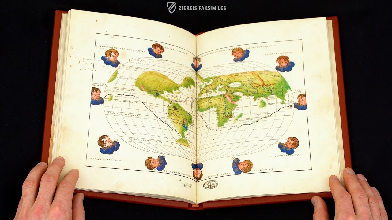
The next three double-page portolan charts depict the Atlantic, Indian, and Pacific Oceans, all reflecting the most recent discoveries made by European seafarers. Six double-page portolan charts depicting various regions of Europe, the Mediterranean, and the Black Sea follow. The atlas concludes with Agnese’s famous world map in oval projection decorated on the edges with the twelve classical compass winds taking the form of cherubs, which are presented with their names in Latin and Greek. The routes taken by the explorer Ferdinand Magellan (1480–1521) and the conquistador Francisco Pizarro (ca. 1471/76–1541) are depicted in black and gold, respectively. The golden color represents the legendary gold treasures that Pizarro brought back to Spain, while the dark color of the Magellan route may have imaginatively reminded one of the precious cloves and nutmeg from the Maluku Islands. Parts of the world that are yet unknown to Europeans and thus incomplete on other maps in the atlas, such as the western coast of South America, are completed in the world map because it is intended to give an overall impression rather than be an accurate representation.
The Barberini Library
A century after Henry VIII’s death, the manuscript was acquired by the Barberini family, who sent agents across Europe to acquire such book treasures. The Barberini were members of the Roman nobility who rose to prominence during the 17th century and eventually had a member of their family placed on the throne of Saint Peter in 1623 as Pope Urban VIII (1568–1644). Their wealth and excellent taste as patrons of the arts were put on display in the Palazzo Barberini, which also housed the Barberini library, which is now a core section of the Vatican's Biblioteca Apostolica. The hemisphere depicting the globe and the most recent geographic knowledge of the New World would have been outdated by the mid-17th century. Therefore, a piece of paper with a colored print was pasted over the parchment page. It depicts the Barberiniana, or more precisely the library room in the south wing of the Barberini’s city palace at Quatro Fontane, which Francesco Barberini (1597–1679), cardinal-nephew of Pope Urban VIII, had specially arranged for his ambitious book collection. Having just been remodeled in the Baroque style between 1627 and 1638, the image shows the recently completed hall, which features two medallion portraits with his papal uncle Maffeo on the left and Francesco himself on the right. Finally, the Barberini had the binding embossed with golden bees, their heraldic symbol.
Codicology
- Alternative Titles
- Atlas Heinrichs VIII.
- Size / Format
- 30 pages / 29.0 × 21.0 cm
- Origin
- Italy
- Date
- 1542–1547
- Epochs
- Style
- Genre
- Language
- Script
- Gothic Hybrida, Humanistic cursive, Square Capitals
- Illustrations
- 10 double page maps, 2 compass roses, titles and emblems of Henry VIII
- Content
- Declination table, armillary sphere, signs of the zodiac, portolan charts of the Atlantic, Indian Ocean, and Pacific, portolan charts of Europe and the Mediterranean region, world map, compass
- Patron
- King Henry VIII of England (1491–1547)
- Artist / School
- Battista Agnese (ca. 1500–64)
- Previous Owners
- King Henry VIII of England (1491–1547)
")
Atlas of Henry VIII
British Isles, France, and the Low Countries
Complete with Portolan lines, this map accurately depicts the coastlines, major rivers, mountain ranges, and most important cities of Western Europe, albeit with some notable exceptions, especially Scotland. The remoteness of SCOTIA (as it is labelled) relative to Venice, where the atlas was made, is obvious by how sparsely labelled it is. Otherwise, Agnese made every attempt to include the names of as many coastal cities as possible while drawing islands in red, green, and gold.
")
Atlas of Henry VIII
World Map
This is one of the most famous maps created by Battista Agnese. Surprisingly accurate, it represents the state of knowledge of mid-16th century European cartographers and is rendered in an oval projection resembling a modern map. Nonetheless, this is a synthesis of the arts meant for display as a luxury item than being a practical aid for navigators.
Brush strokes of gold leaf are judiciously applied across the double-page image, ranging from marking significant cities to highlighting the hair of the figures blowing the world’s winds. However, the most interesting features of this map are the lines that run from the Iberian Peninsula tracing the voyages of explorers like Columbus and Magellan, which had only recently been undertaken.
")
#1 Atlas Heinrichs VIII. Battista Agnese. Barb. Lat. 4357
Language: German
(1,000€ - 3,000€)
")
")
 – National Library of Russia (St. Petersburg, Russia)")
")
")
")
- Treatises / Secular Books
- Apocalypses / Beatus
- Astronomy / Astrology
- Bestiaries
- Bibles / Gospels
- Chronicles / History / Law
- Geography / Maps
- Saints' Lives
- Islam / Oriental
- Judaism / Hebrew
- Single Leaf Collections
- Leonardo da Vinci
- Literature / Poetry
- Liturgical Manuscripts
- Medicine / Botany / Alchemy
- Music
- Mythology / Prophecies
- Psalters
- Other Religious Books
- Games / Hunting
- Private Devotion Books
- Other Genres
- Afghanistan
- Armenia
- Austria
- Belgium
- Belize
- Bosnia and Herzegovina
- China
- Colombia
- Costa Rica
- Croatia
- Cyprus
- Czech Republic
- Denmark
- Egypt
- El Salvador
- Ethiopia
- France
- Germany
- Greece
- Guatemala
- Honduras
- Hungary
- India
- Iran
- Iraq
- Israel
- Italy
- Japan
- Jordan
- Kazakhstan
- Kyrgyzstan
- Lebanon
- Liechtenstein
- Luxembourg
- Mexico
- Morocco
- Netherlands
- Palestine
- Panama
- Peru
- Poland
- Portugal
- Romania
- Russia
- Serbia
- Spain
- Sri Lanka
- Sweden
- Switzerland
- Syria
- Tajikistan
- Turkey
- Turkmenistan
- Ukraine
- United Kingdom
- United States
- Uzbekistan
- Vatican City
- A. Oosthoek, van Holkema & Warendorf
- Aboca Museum
- Ajuntament de Valencia
- Akademie Verlag
- Akademische Druck- u. Verlagsanstalt (ADEVA)
- Aldo Ausilio Editore - Bottega d’Erasmo
- Alecto Historical Editions
- Alkuin Verlag
- Almqvist & Wiksell
- Amilcare Pizzi
- Andreas & Andreas Verlagsbuchhandlung
- Archa 90
- Archiv Verlag
- Archivi Edizioni
- Arnold Verlag
- ARS
- Ars Magna
- Ars Millenii
- Art Market
- ArtCodex
- AyN Ediciones
- Azimuth Editions
- Badenia Verlag
- Bärenreiter-Verlag
- Belser Verlag
- Belser Verlag / WK Wertkontor
- Benziger Verlag
- Bernardinum Wydawnictwo
- BiblioGemma
- Biblioteca Apostolica Vaticana (Vaticanstadt, Vaticanstadt)
- Bibliotheca Palatina Faksimile Verlag
- Bibliotheca Rara
- Boydell & Brewer
- Bramante Edizioni
- Bredius Genootschap
- Brepols Publishers
- British Library
- Brokarte
- C. Weckesser
- Caixa Catalunya
- Canesi
- CAPSA, Ars Scriptoria
- Caratzas Brothers, Publishers
- Carus Verlag
- Casamassima Libri
- Centrum Cartographie Verlag GmbH
- Chavane Verlag
- Christian Brandstätter Verlag
- Circulo Cientifico
- Club Bibliófilo Versol
- Club du Livre
- Club Internacional del Libro
- CM Editores
- Collegium Graphicum
- Collezione Apocrifa Da Vinci
- Comissão Nacional para as Comemorações dos Descobrimentos Portugueses
- Coron Verlag
- Corvina
- CTHS
- D. S. Brewer
- Damon
- De Agostini/UTET
- De Nederlandsche Boekhandel
- De Schutter
- Deuschle & Stemmle
- Deutscher Verlag für Kunstwissenschaft
- DIAMM
- Dropmore Press
- Droz
- E. Schreiber Graphische Kunstanstalten
- Ediciones Boreal
- Ediciones Grial
- Ediclube
- Edições Inapa
- Edilan
- Editalia
- Edition Deuschle
- Edition Georg Popp
- Edition Leipzig
- Edition Libri Illustri
- Editiones Reales Sitios S. L.
- Éditions de l'Oiseau Lyre
- Editions Medicina Rara
- Editorial Casariego
- Editorial Mintzoa
- Editrice Antenore
- Editrice Velar
- Edizioni Edison
- Egeria, S.L.
- Eikon Editores
- Electa
- Emery Walker Limited
- Enciclopèdia Catalana
- Eos-Verlag
- Ephesus Publishing
- Ernst Battenberg
- Eugrammia Press
- Extraordinary Editions
- Fackelverlag
- Facsimila Art & Edition
- Facsimile Editions Ltd.
- Facsimilia Art & Edition Ebert KG
- Faksimile Verlag
- Feuermann Verlag
- Folger Shakespeare Library
- Franco Cosimo Panini Editore
- Friedrich Wittig Verlag
- Fundación Hullera Vasco-Leonesa
- G. Braziller
- Gabriele Mazzotta Editore
- Gebr. Mann Verlag
- Gesellschaft für graphische Industrie
- Getty Research Institute
- Giovanni Domenico de Rossi
- Giunti Editore
- Goldenmark Librarium
- Graffiti
- Grafica European Center of Fine Arts
- Guido Pressler
- Guillermo Blazquez
- Gustav Kiepenheuer
- H. N. Abrams
- Harrassowitz
- Harvard University Press
- Helikon
- Hendrickson Publishers
- Henning Oppermann
- Herder Verlag
- Hes & De Graaf Publishers
- Hoepli
- Holbein-Verlag
- Houghton Library
- Hugo Schmidt Verlag
- Hungarian Academy of Sciences
- Idion Verlag
- Il Bulino, edizioni d'arte
- ILte
- Imago
- Insel Verlag
- Insel-Verlag Anton Kippenberger
- Instituto de Estudios Altoaragoneses
- Instituto Nacional de Antropología e Historia
- Introligatornia Budnik Jerzy
- Istituto dell'Enciclopedia Italiana - Treccani
- Istituto Ellenico di Studi Bizantini e Postbizantini
- Istituto Geografico De Agostini
- Istituto Poligrafico e Zecca dello Stato
- Italarte Art Establishments
- Jaca Book
- Jan Thorbecke Verlag
- Johnson Reprint Corporation
- Johnson Reprint Corporation
- Jos. Baer
- Josef Stocker
- Josef Stocker-Schmid
- Jugoslavija
- Karl W. Hiersemann
- Kasper Straube
- Kaydeda Ediciones
- Kindler Verlag / Coron Verlag
- Kodansha International Ltd.
- Konrad Kölbl Verlag
- Kurt Wolff Verlag
- La Liberia dello Stato
- La Linea Editrice
- La Meta Editore
- Lambert Schneider
- Landeskreditbank Baden-Württemberg
- Leo S. Olschki
- Les Incunables
- Liber Artis
- Library of Congress
- Libreria Musicale Italiana
- Lichtdruck
- Lito Immagine Editore
- Lumen Artis
- Lund Humphries
- M. Moleiro Editor
- Maison des Sciences de l'homme et de la société de Poitiers
- Manuscriptum
- Martinus Nijhoff
- Maruzen-Yushodo Co. Ltd.
- MASA
- Massada Publishers
- McGraw-Hill
- Metropolitan Museum of Art
- Militos
- Millennium Liber
- Müller & Schindler
- Nahar - Stavit
- Nahar and Steimatzky
- National Library of Wales
- Neri Pozza
- Nova Charta
- Oceanum Verlag
- Odeon
- Omnia Arte
- Orbis Mediaevalis
- Orbis Pictus
- Österreichische Staatsdruckerei
- Oxford University Press
- Pageant Books
- Parzellers Buchverlag
- Patrimonio Ediciones
- Pattloch Verlag
- PIAF
- Pieper Verlag
- Plon-Nourrit et cie
- Poligrafiche Bolis
- Presses Universitaires de Strasbourg
- Prestel Verlag
- Princeton University Press
- Prisma Verlag
- Priuli & Verlucca, editori
- Pro Sport Verlag
- Propyläen Verlag
- Pytheas Books
- Quaternio Verlag Luzern
- Reales Sitios
- Recht-Verlag
- Reichert Verlag
- Reichsdruckerei
- Reprint Verlag
- Riehn & Reusch
- Roberto Vattori Editore
- Rosenkilde and Bagger
- Roxburghe Club
- Salerno Editrice
- Saltellus Press
- Sandoz
- Sarajevo Svjetlost
- Schöck ArtPrint Kft.
- Schulsinger Brothers
- Scolar Press
- Scrinium
- Scripta Maneant
- Scriptorium
- Shazar
- Siloé, arte y bibliofilia
- SISMEL - Edizioni del Galluzzo
- Sociedad Mexicana de Antropología
- Société des Bibliophiles & Iconophiles de Belgique
- Soncin Publishing
- Sorli Ediciones
- Stainer and Bell
- Studer
- Styria Verlag
- Sumptibus Pragopress
- Szegedi Tudomànyegyetem
- Taberna Libraria
- Tarshish Books
- Taschen
- Tempus Libri
- Testimonio Compañía Editorial
- TGB Limited Editions
- Thames and Hudson
- The Clear Vue Publishing Partnership Limited
- The Facsimile Codex
- The Folio Society
- The Marquess of Normanby
- The Orphan Hospital Ward of Israel
- The Richard III and Yorkist History Trust
- The Warburg Institute
- Tip.Le.Co
- TouchArt
- TREC Publishing House
- TRI Publishing Co.
- Trident Editore
- Tuliba Collection
- Typis Regiae Officinae Polygraphicae
- Union Verlag Berlin
- Universidad de Granada
- Universitaire Bibliotheken Leiden
- University of California Press
- University of Chicago Press
- Urs Graf
- Vallecchi
- Van Wijnen
- VCH, Acta Humaniora
- VDI Verlag
- VEB Deutscher Verlag für Musik
- Verein Schweizerischer Lithographie-Besitzer
- Verlag Anton Pustet / Andreas Verlag
- Verlag Bibliophile Drucke Josef Stocker
- Verlag der Münchner Drucke
- Verlag für Regionalgeschichte
- Verlag Styria
- Vicent Garcia Editores
- W. Turnowsky
- Waanders Printers
- Wiener Mechitharisten-Congregation (Wien, Österreich)
- Wissenschaftliche Buchgesellschaft
- Wissenschaftliche Verlagsgesellschaft
- Wydawnictwo Dolnoslaskie
- Xuntanza Editorial
- Zakład Narodowy
- Zollikofer AG