King Henry's Map of the British Isles
")
England — 1536–1537
A magnificent map of his emerging island kingdom from southern England to Wales to Ireland and Scotland: the gift to King Henry VIII of England was valuable as it was practical
The 1537 map Angliae Figura was a gift from the Archdeacon of Rochester to King Henry VIII (1491–1547)
Henry's kingdom, from Southern England across Wales to Ireland and up to Scotland, is gorgeously presented
It hung in Hampton Court Palace, the King’s favorite residence, and continuously presented his empire
King Henry's Map of the British Isles

")
")
")
")
")
")
")
")
")
")
")
")
")
(1,000€ - 3,000€)
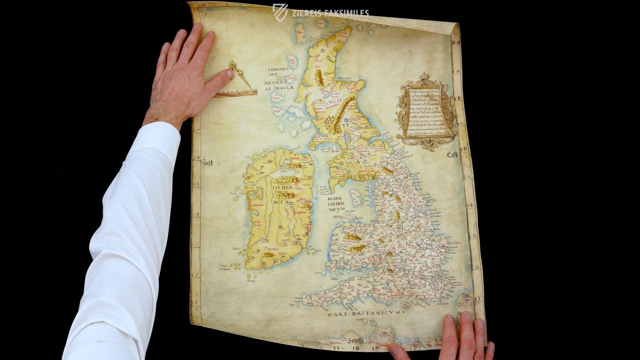
This splendid map from the year 1537 presents the kingdom of Henry VIII of England. It hung in Hampton Court Palace, the King’s favorite residence, and continuously presented his British empire to the monarch. The map titled Angliae Figura was a gift from the archdeacon of Rochester to Henry VIII. The British Kingdom is presented in gorgeous form, from Southern England across Wales to Ireland and up to Scotland. In this way, the spirit of the 16th century under the reign of Henry VIII comes to life!
King Henry's Map of the British Isles
This splendid map from the year 1537 presents the realm of Henry VIII of England (1491–1547). It hung in Hampton Court Palace, the King’s favorite residence, and continuously presented his British empire to the monarch. The map titled Titel Angliae Figura was a gift from the archdeacon of Rochester to Henry VIII. The British Isles are presented in gorgeous form, from Southern England across Wales to Ireland and up to Scotland. In this way, the spirit of the 16th century under the reign of Henry VIII comes to life!
The Impressive Kingdom of Britain
The map with the shelf mark B.L. Cotton MS Augustus I.i.9 of the British Library in London is one of the greatest treasures of the collections. In this map of Henry VIII’s, the British Isles as a whole are depicted in detail. From the south of England over Wales and Ireland and up to the northern-most islands of Scotland, the entire region of the British Isles is represented. Additionally, Northern France is also depicted. This is a sign that the map not only showed geographic conditions, but also the Kingdom of England as Henry saw it.
A Modern Map of the 16th Century
Ireland and Scotland are drawn in a yellow tone, England on the other hand is white and furnished with a multitude of place names – 633 in all. Alongside the names of places and provinces in red and black, numerous rivers, bodies of water, and islands off the coasts are recorded. The map is made according to the most modern state of cartography at the time. A compass establishes the scale, and a schedule of coordinates is found on all four margins of the page. The title of the map is listed in a splendidly decorated cartouche on the upper right margin: Angliae Figura.
A Gift for the Famous King
This parchment map measuring 64 x 46 cm, made in England during the years 1536/7, originated from the commission of the archdeacon of Rochester, who presented the map to the English King as a New Year’s gift for the year 1537. The map was of great significance for Henry VIII and was probably viewed and admired by him countless times. His entire realm is shown here in the most realistic depiction of the British Isles of that time. The walls of Hampton Court Palace, the favorite residence of Henry VIII, were adorned with this permanent reference to the power of the King!
Codicology
- Alternative Titles
- Anglia Figura
Cottonian map
Karte der Britischen Inseln König Heinrichs VIII. - Type
- Map on parchment
- Size / Format
- 1 map / 64.0 × 46.0 cm
- Origin
- United Kingdom
- Date
- 1536–1537
- Epochs
- Style
- Genre
- Language
- Patron
- Archdeacon of Rochester
- Previous Owners
- Sir Robert Cotton (1571–1631)
")
King Henry's Map of the British Isles
MARE HYBERNICUM
The Irish Sea lies at the center of the British Isles, it is where the shores of Ireland, Scotland, England, and Wales all meet. Rivers are shown coursing the way to the sea as are several important cities including Dublin (Dublinia) and Liverpool (Leúpole). Individual islands are labelled, such as the Isle of Mann (Mania) and the Isle of Anglesey (Mona), as well as several island chains. The most important locations are labelled in expensive red ink.
")
King Henry's Map of the British Isles
England, Scotland, and Ireland
This map from 1537 is artfully created and aside from some of the more remote corners of the British Isles, such as the southern and western coasts of Ireland, are depicted with a surprising level of detail. While England is depicted in white, the neighboring realms of Scotland and Ireland are yellow. A compass in the upper left establishes the scale of the map, which bears the title Angliae Figura.
As a gift to King Henry VIII of England, this document was intended to not only depict the realms that the King either ruled or desired to rule, but to also depict the most advanced state of British cartography in a manner that is simultaneously artful. It accomplished all three goals and as such was proudly hung in Hampton Court Palace.
")
#1 King Henry's Map of the British Isles
(1,000€ - 3,000€)
")

")
")
")
")

- Treatises / Secular Books
- Apocalypses / Beatus
- Astronomy / Astrology
- Bestiaries
- Bibles / Gospels
- Chronicles / History / Law
- Geography / Maps
- Saints' Lives
- Islam / Oriental
- Judaism / Hebrew
- Single Leaf Collections
- Leonardo da Vinci
- Literature / Poetry
- Liturgical Manuscripts
- Medicine / Botany / Alchemy
- Music
- Mythology / Prophecies
- Psalters
- Other Religious Books
- Games / Hunting
- Private Devotion Books
- Other Genres
- Afghanistan
- Armenia
- Austria
- Belgium
- Belize
- Bosnia and Herzegovina
- China
- Colombia
- Costa Rica
- Croatia
- Cyprus
- Czech Republic
- Denmark
- Egypt
- El Salvador
- Ethiopia
- France
- Germany
- Greece
- Guatemala
- Honduras
- Hungary
- India
- Iran
- Iraq
- Israel
- Italy
- Japan
- Jordan
- Kazakhstan
- Kyrgyzstan
- Lebanon
- Liechtenstein
- Luxembourg
- Mexico
- Morocco
- Netherlands
- Palestine
- Panama
- Peru
- Poland
- Portugal
- Romania
- Russia
- Serbia
- Spain
- Sri Lanka
- Sweden
- Switzerland
- Syria
- Tajikistan
- Turkey
- Turkmenistan
- Ukraine
- United Kingdom
- United States
- Uzbekistan
- Vatican City
- A. Oosthoek, van Holkema & Warendorf
- Aboca Museum
- Ajuntament de Valencia
- Akademie Verlag
- Akademische Druck- u. Verlagsanstalt (ADEVA)
- Aldo Ausilio Editore - Bottega d’Erasmo
- Alecto Historical Editions
- Alkuin Verlag
- Almqvist & Wiksell
- Amilcare Pizzi
- Andreas & Andreas Verlagsbuchhandlung
- Archa 90
- Archiv Verlag
- Archivi Edizioni
- Arnold Verlag
- ARS
- Ars Magna
- Ars Millenii
- Art Market
- ArtCodex
- AyN Ediciones
- Azimuth Editions
- Badenia Verlag
- Bärenreiter-Verlag
- Belser Verlag
- Belser Verlag / WK Wertkontor
- Benziger Verlag
- Bernardinum Wydawnictwo
- BiblioGemma
- Biblioteca Apostolica Vaticana (Vaticanstadt, Vaticanstadt)
- Bibliotheca Palatina Faksimile Verlag
- Bibliotheca Rara
- Boydell & Brewer
- Bramante Edizioni
- Bredius Genootschap
- Brepols Publishers
- British Library
- Brokarte
- C. Weckesser
- Caixa Catalunya
- Canesi
- CAPSA, Ars Scriptoria
- Caratzas Brothers, Publishers
- Carus Verlag
- Casamassima Libri
- Centrum Cartographie Verlag GmbH
- Chavane Verlag
- Christian Brandstätter Verlag
- Circulo Cientifico
- Club Bibliófilo Versol
- Club du Livre
- Club Internacional del Libro
- CM Editores
- Collegium Graphicum
- Collezione Apocrifa Da Vinci
- Comissão Nacional para as Comemorações dos Descobrimentos Portugueses
- Coron Verlag
- Corvina
- CTHS
- D. S. Brewer
- Damon
- De Agostini/UTET
- De Nederlandsche Boekhandel
- De Schutter
- Deuschle & Stemmle
- Deutscher Verlag für Kunstwissenschaft
- DIAMM
- Dropmore Press
- Droz
- E. Schreiber Graphische Kunstanstalten
- Ediciones Boreal
- Ediciones Grial
- Ediclube
- Edições Inapa
- Edilan
- Editalia
- Edition Deuschle
- Edition Georg Popp
- Edition Leipzig
- Edition Libri Illustri
- Editiones Reales Sitios S. L.
- Éditions de l'Oiseau Lyre
- Editions Medicina Rara
- Editorial Casariego
- Editorial Mintzoa
- Editrice Antenore
- Editrice Velar
- Edizioni Edison
- Egeria, S.L.
- Eikon Editores
- Electa
- Emery Walker Limited
- Enciclopèdia Catalana
- Eos-Verlag
- Ephesus Publishing
- Ernst Battenberg
- Eugrammia Press
- Extraordinary Editions
- Fackelverlag
- Facsimila Art & Edition
- Facsimile Editions Ltd.
- Facsimilia Art & Edition Ebert KG
- Faksimile Verlag
- Feuermann Verlag
- Folger Shakespeare Library
- Franco Cosimo Panini Editore
- Friedrich Wittig Verlag
- Fundación Hullera Vasco-Leonesa
- G. Braziller
- Gabriele Mazzotta Editore
- Gebr. Mann Verlag
- Gesellschaft für graphische Industrie
- Getty Research Institute
- Giovanni Domenico de Rossi
- Giunti Editore
- Goldenmark Librarium
- Graffiti
- Grafica European Center of Fine Arts
- Guido Pressler
- Guillermo Blazquez
- Gustav Kiepenheuer
- H. N. Abrams
- Harrassowitz
- Harvard University Press
- Helikon
- Hendrickson Publishers
- Henning Oppermann
- Herder Verlag
- Hes & De Graaf Publishers
- Hoepli
- Holbein-Verlag
- Houghton Library
- Hugo Schmidt Verlag
- Hungarian Academy of Sciences
- Idion Verlag
- Il Bulino, edizioni d'arte
- ILte
- Imago
- Insel Verlag
- Insel-Verlag Anton Kippenberger
- Instituto de Estudios Altoaragoneses
- Instituto Nacional de Antropología e Historia
- Introligatornia Budnik Jerzy
- Istituto dell'Enciclopedia Italiana - Treccani
- Istituto Ellenico di Studi Bizantini e Postbizantini
- Istituto Geografico De Agostini
- Istituto Poligrafico e Zecca dello Stato
- Italarte Art Establishments
- Jaca Book
- Jan Thorbecke Verlag
- Johnson Reprint Corporation
- Johnson Reprint Corporation
- Jos. Baer
- Josef Stocker
- Josef Stocker-Schmid
- Jugoslavija
- Karl W. Hiersemann
- Kasper Straube
- Kaydeda Ediciones
- Kindler Verlag / Coron Verlag
- Kodansha International Ltd.
- Konrad Kölbl Verlag
- Kurt Wolff Verlag
- La Liberia dello Stato
- La Linea Editrice
- La Meta Editore
- Lambert Schneider
- Landeskreditbank Baden-Württemberg
- Leo S. Olschki
- Les Incunables
- Liber Artis
- Library of Congress
- Libreria Musicale Italiana
- Lichtdruck
- Lito Immagine Editore
- Lumen Artis
- Lund Humphries
- M. Moleiro Editor
- Maison des Sciences de l'homme et de la société de Poitiers
- Manuscriptum
- Martinus Nijhoff
- Maruzen-Yushodo Co. Ltd.
- MASA
- Massada Publishers
- McGraw-Hill
- Metropolitan Museum of Art
- Militos
- Millennium Liber
- Müller & Schindler
- Nahar - Stavit
- Nahar and Steimatzky
- National Library of Wales
- Neri Pozza
- Nova Charta
- Oceanum Verlag
- Odeon
- Omnia Arte
- Orbis Mediaevalis
- Orbis Pictus
- Österreichische Staatsdruckerei
- Oxford University Press
- Pageant Books
- Parzellers Buchverlag
- Patrimonio Ediciones
- Pattloch Verlag
- PIAF
- Pieper Verlag
- Plon-Nourrit et cie
- Poligrafiche Bolis
- Presses Universitaires de Strasbourg
- Prestel Verlag
- Princeton University Press
- Prisma Verlag
- Priuli & Verlucca, editori
- Pro Sport Verlag
- Propyläen Verlag
- Pytheas Books
- Quaternio Verlag Luzern
- Reales Sitios
- Recht-Verlag
- Reichert Verlag
- Reichsdruckerei
- Reprint Verlag
- Riehn & Reusch
- Roberto Vattori Editore
- Rosenkilde and Bagger
- Roxburghe Club
- Salerno Editrice
- Saltellus Press
- Sandoz
- Sarajevo Svjetlost
- Schöck ArtPrint Kft.
- Schulsinger Brothers
- Scolar Press
- Scrinium
- Scripta Maneant
- Scriptorium
- Shazar
- Siloé, arte y bibliofilia
- SISMEL - Edizioni del Galluzzo
- Sociedad Mexicana de Antropología
- Société des Bibliophiles & Iconophiles de Belgique
- Soncin Publishing
- Sorli Ediciones
- Stainer and Bell
- Studer
- Styria Verlag
- Sumptibus Pragopress
- Szegedi Tudomànyegyetem
- Taberna Libraria
- Tarshish Books
- Taschen
- Tempus Libri
- Testimonio Compañía Editorial
- TGB Limited Editions
- Thames and Hudson
- The Clear Vue Publishing Partnership Limited
- The Facsimile Codex
- The Folio Society
- The Marquess of Normanby
- The Orphan Hospital Ward of Israel
- The Richard III and Yorkist History Trust
- The Warburg Institute
- Tip.Le.Co
- TouchArt
- TREC Publishing House
- TRI Publishing Co.
- Trident Editore
- Tuliba Collection
- Typis Regiae Officinae Polygraphicae
- Union Verlag Berlin
- Universidad de Granada
- Universitaire Bibliotheken Leiden
- University of California Press
- University of Chicago Press
- Urs Graf
- Vallecchi
- Van Wijnen
- VCH, Acta Humaniora
- VDI Verlag
- VEB Deutscher Verlag für Musik
- Verein Schweizerischer Lithographie-Besitzer
- Verlag Anton Pustet / Andreas Verlag
- Verlag Bibliophile Drucke Josef Stocker
- Verlag der Münchner Drucke
- Verlag für Regionalgeschichte
- Verlag Styria
- Vicent Garcia Editores
- W. Turnowsky
- Waanders Printers
- Wiener Mechitharisten-Congregation (Wien, Österreich)
- Wissenschaftliche Buchgesellschaft
- Wissenschaftliche Verlagsgesellschaft
- Wydawnictwo Dolnoslaskie
- Xuntanza Editorial
- Zakład Narodowy
- Zollikofer AG