Queen Mary Atlas
")
England — 1555–1557
An opulent gift from Maria Tudor to her husband Philip II: 10 magnificent double-page maps by the virtuoso Portuguese cartographer Diogo Homem as a representation of the hegemony of the Spanish Empire
A masterful gift from Queen Mary Tudor (1516–1558) to her husband Philip (1527–98), the future King of Spain
The famous cartographer Diogo Homem (1521–76) created ten magnificent, double-page maps of Philip's empire
This fabulous gift reflected Philip's tastes, who was a lover of cartography and a tremendous art patron
Queen Mary Atlas

")
")
")
")
")
")
")
")
")
")
")
")
")
")
")
")
")
")
")
")
")
")
")
")
")
")
")
")
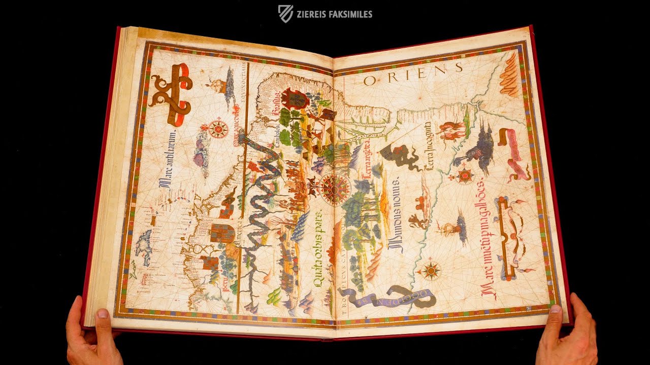
The Queen Mary Atlas is a truly royal gift: the English Catholic Queen Mary I Tudor (1516–1558) commissioned the precious map work as a gift for her husband Philip II (1527–1598), who later became King of Spain. The 9 double-page maps allowed him, as a proven map lover, to envision his future world empire. The famous Portuguese cartographer Diego Homem (1521–1576) was responsible for this masterpiece of early modern cartography transferring the entire world known in Europe at the time in the most artistic way onto parchment. Particularly impressive are the maps of the just recently “discovered” New World, which bear witness to the findings of the many Portuguese expeditions in the 60 years following Columbus. The coastlines are characterized by astonishing accuracy and the atlas contains the earliest cartographic representation of Nova Scotia and the Bay of Fundy. With his large-format, splendidly colorful and gold-decorated maps, Homem undoubtedly created one of the most beautiful atlases in the history of books.
Queen Mary Atlas
This masterpiece of 16th century cartography arose as a gift from Queen Mary Tudor to her husband Philip, who would be King of Spain: one of the most beautiful atlases in the history of illumination! As a work of the famous Portuguese cartographer Diogo Homem the Queen Mary Atlas enchants with ten magnificent, double-page maps. These splendidly colorful, large-format depictions are gorgeously designed with numerous details. In this way, Philip II – a well-known lover of maps – was able to spectacularly visualize his great empire!
The Best Cartographer of His Time
A special treasure is stored under the shelf mark Add. MS 5415A in the British Library in London: the famous Queen Mary Atlas. Around the middle of the 16th century, Mary Tudor (1516–1558), daughter of the English King Henry VIII and Catherine of Aragon, gave the commission for this splendid cartographic work to one of the greatest members of that fraternity: the Portuguese cartographer Diogo Homem (1521–1576). He was the founder of a famous dynasty of Portuguese cartographers. After being accused of murder, Diogo Homem had to flee Portugal, going first to England and later to Venice. There he would become famous for his maps – usually of the Mediterranean Sea. Diogo Homem is considered today to be one of the greatest cartographers of his time!
A Cartographic Masterpiece
Diogo Homem completed his royal commission in 1555. Ten double-sided maps and astronomical charts visualize the image of the world at the time of the Renaissance on 24 pages of parchment. In a large format of 78 x 56 cm, the atlas impresses with its high-quality design. Numerous illustrations adorn the geographic depictions, e.g. compass roses, tables, flags and coats of arms, but also figurative scenes like ships on the sea and mythic, historic, and country-specific figures and the like. Large and famous cities were presented in small vignettes, and were designed with gorgeous colors, various decorative frames round out the magnificent overall impression.
A Gift for a Royal Husband
The so-called Queen Mary Atlas counts among the most beautiful atlases in the history of illumination. Queen Mary of England commissioned the atlas at the time of her 1554 marriage to Philip, the successor to the Spanish throne, son of Charles V and eventually King Philip II of Spain. The work was intended as a fabulous gift to her husband Philip. Philip II had a great passion for maps. Thus it was assuredly a great joy for him to receive this particularly accomplished specimen, a gift from his wife that visualized his extensive empire!
Codicology
- Alternative Titles
- Diogo Homem Atlas
Atlas de Diogo Homem - Type
- Map on parchment
- Size / Format
- 24 pages / 80.0 × 58.0 cm
- Origin
- United Kingdom
- Date
- 1555–1557
- Epochs
- Style
- Genre
- Language
- Script
- Gothic Textura Quadrata
- Illustrations
- Richly decorated with compass roses, sailing ships, coats of arms, flags, cities, human and animal figures, and more
- Content
- Astronomical tables, 1 zonal map, 9 double-page maps: World map, South America, South Atlantic, North Atlantic, British Isles, Eastern Pacific, South East Asia, Indian Ocean, Western Mediterranean
- Patron
- Queen Mary I of England (1516–58)
- Artist / School
- Diogo Homem (1521–76)
- Previous Owners
- King Philip II of Spain (1527–98)
")
Queen Mary Atlas
Italy
The Italian peninsula is not only easily recognizable by its shape on the map of the Mediterranean. Several city illuminations adorn the land mass and testify to the importance of these urban centers of trade and power. Rome appears very prominently on its seven hills, distinguished by a flag with the papal coat of arms (two crossed keys and a tiara). Further north, probably Pisa is highlighted as one of the most important cities in Tuscany, which was under Medici rule at the time of creation, as indicated by the golden flag with its five red balls.
")
Queen Mary Atlas
World Map
The world map of the Queen Mary Atlas represents the world as it was known in 1558, as stated in the surrounding frame inscription: “Universalis mundi figura atque navigationum orbis terrarium scitus” – “Depiction of the whole world and the explored countries of the earth”. Australia and Antarctica are still completely missing, while large parts of the Americas have already been mapped. The large cartographic uncertainties in the northern regions of North America and Asia are also striking.
The few coats of arms depicted visualize the rough division of the world primarily between Spain and Portugal (red and gold coat of arms vs. blue shields with five dots on a silver field) – of course from a Spanish perspective. The inscription at the bottom right testifies to the completion of the map work in 1558 by Diego Homem, the year of Queen Elizabeth I's enthronement.
")
#1 Queen Mary Atlas
Language: English
 / GE DD-683 (2-5 RES) / GE AA-640 (RES) – Bibliothèque nationale de France (Paris, France)")
")
")
")
")
- Treatises / Secular Books
- Apocalypses / Beatus
- Astronomy / Astrology
- Bestiaries
- Bibles / Gospels
- Chronicles / History / Law
- Geography / Maps
- Saints' Lives
- Islam / Oriental
- Judaism / Hebrew
- Single Leaf Collections
- Leonardo da Vinci
- Literature / Poetry
- Liturgical Manuscripts
- Medicine / Botany / Alchemy
- Music
- Mythology / Prophecies
- Psalters
- Other Religious Books
- Games / Hunting
- Private Devotion Books
- Other Genres
- Afghanistan
- Armenia
- Austria
- Belgium
- Belize
- Bosnia and Herzegovina
- China
- Colombia
- Costa Rica
- Croatia
- Cyprus
- Czech Republic
- Denmark
- Egypt
- El Salvador
- Ethiopia
- France
- Germany
- Greece
- Guatemala
- Honduras
- Hungary
- India
- Iran
- Iraq
- Israel
- Italy
- Japan
- Jordan
- Kazakhstan
- Kyrgyzstan
- Lebanon
- Liechtenstein
- Luxembourg
- Mexico
- Morocco
- Netherlands
- Palestine
- Panama
- Peru
- Poland
- Portugal
- Romania
- Russia
- Serbia
- Spain
- Sri Lanka
- Sweden
- Switzerland
- Syria
- Tajikistan
- Turkey
- Turkmenistan
- Ukraine
- United Kingdom
- United States
- Uzbekistan
- Vatican City
- A. Oosthoek, van Holkema & Warendorf
- Aboca Museum
- Ajuntament de Valencia
- Akademie Verlag
- Akademische Druck- u. Verlagsanstalt (ADEVA)
- Aldo Ausilio Editore - Bottega d’Erasmo
- Alecto Historical Editions
- Alkuin Verlag
- Almqvist & Wiksell
- Amilcare Pizzi
- Andreas & Andreas Verlagsbuchhandlung
- Archa 90
- Archiv Verlag
- Archivi Edizioni
- Arnold Verlag
- ARS
- Ars Magna
- Ars Millenii
- Art Market
- ArtCodex
- AyN Ediciones
- Azimuth Editions
- Badenia Verlag
- Bärenreiter-Verlag
- Belser Verlag
- Belser Verlag / WK Wertkontor
- Benziger Verlag
- Bernardinum Wydawnictwo
- BiblioGemma
- Biblioteca Apostolica Vaticana (Vaticanstadt, Vaticanstadt)
- Bibliotheca Palatina Faksimile Verlag
- Bibliotheca Rara
- Boydell & Brewer
- Bramante Edizioni
- Bredius Genootschap
- Brepols Publishers
- British Library
- Brokarte
- C. Weckesser
- Caixa Catalunya
- Canesi
- CAPSA, Ars Scriptoria
- Caratzas Brothers, Publishers
- Carus Verlag
- Casamassima Libri
- Centrum Cartographie Verlag GmbH
- Chavane Verlag
- Christian Brandstätter Verlag
- Circulo Cientifico
- Club Bibliófilo Versol
- Club du Livre
- Club Internacional del Libro
- CM Editores
- Collegium Graphicum
- Collezione Apocrifa Da Vinci
- Comissão Nacional para as Comemorações dos Descobrimentos Portugueses
- Coron Verlag
- Corvina
- CTHS
- D. S. Brewer
- Damon
- De Agostini/UTET
- De Nederlandsche Boekhandel
- De Schutter
- Deuschle & Stemmle
- Deutscher Verlag für Kunstwissenschaft
- DIAMM
- Dropmore Press
- Droz
- E. Schreiber Graphische Kunstanstalten
- Ediciones Boreal
- Ediciones Grial
- Ediclube
- Edições Inapa
- Edilan
- Editalia
- Edition Deuschle
- Edition Georg Popp
- Edition Leipzig
- Edition Libri Illustri
- Editiones Reales Sitios S. L.
- Éditions de l'Oiseau Lyre
- Editions Medicina Rara
- Editorial Casariego
- Editorial Mintzoa
- Editrice Antenore
- Editrice Velar
- Edizioni Edison
- Egeria, S.L.
- Eikon Editores
- Electa
- Emery Walker Limited
- Enciclopèdia Catalana
- Eos-Verlag
- Ephesus Publishing
- Ernst Battenberg
- Eugrammia Press
- Extraordinary Editions
- Fackelverlag
- Facsimila Art & Edition
- Facsimile Editions Ltd.
- Facsimilia Art & Edition Ebert KG
- Faksimile Verlag
- Feuermann Verlag
- Folger Shakespeare Library
- Franco Cosimo Panini Editore
- Friedrich Wittig Verlag
- Fundación Hullera Vasco-Leonesa
- G. Braziller
- Gabriele Mazzotta Editore
- Gebr. Mann Verlag
- Gesellschaft für graphische Industrie
- Getty Research Institute
- Giovanni Domenico de Rossi
- Giunti Editore
- Goldenmark Librarium
- Graffiti
- Grafica European Center of Fine Arts
- Guido Pressler
- Guillermo Blazquez
- Gustav Kiepenheuer
- H. N. Abrams
- Harrassowitz
- Harvard University Press
- Helikon
- Hendrickson Publishers
- Henning Oppermann
- Herder Verlag
- Hes & De Graaf Publishers
- Hoepli
- Holbein-Verlag
- Houghton Library
- Hugo Schmidt Verlag
- Hungarian Academy of Sciences
- Idion Verlag
- Il Bulino, edizioni d'arte
- ILte
- Imago
- Insel Verlag
- Insel-Verlag Anton Kippenberger
- Instituto de Estudios Altoaragoneses
- Instituto Nacional de Antropología e Historia
- Introligatornia Budnik Jerzy
- Istituto dell'Enciclopedia Italiana - Treccani
- Istituto Ellenico di Studi Bizantini e Postbizantini
- Istituto Geografico De Agostini
- Istituto Poligrafico e Zecca dello Stato
- Italarte Art Establishments
- Jaca Book
- Jan Thorbecke Verlag
- Johnson Reprint Corporation
- Johnson Reprint Corporation
- Jos. Baer
- Josef Stocker
- Josef Stocker-Schmid
- Jugoslavija
- Karl W. Hiersemann
- Kasper Straube
- Kaydeda Ediciones
- Kindler Verlag / Coron Verlag
- Kodansha International Ltd.
- Konrad Kölbl Verlag
- Kurt Wolff Verlag
- La Liberia dello Stato
- La Linea Editrice
- La Meta Editore
- Lambert Schneider
- Landeskreditbank Baden-Württemberg
- Leo S. Olschki
- Les Incunables
- Liber Artis
- Library of Congress
- Libreria Musicale Italiana
- Lichtdruck
- Lito Immagine Editore
- Lumen Artis
- Lund Humphries
- M. Moleiro Editor
- Maison des Sciences de l'homme et de la société de Poitiers
- Manuscriptum
- Martinus Nijhoff
- Maruzen-Yushodo Co. Ltd.
- MASA
- Massada Publishers
- McGraw-Hill
- Metropolitan Museum of Art
- Militos
- Millennium Liber
- Müller & Schindler
- Nahar - Stavit
- Nahar and Steimatzky
- National Library of Wales
- Neri Pozza
- Nova Charta
- Oceanum Verlag
- Odeon
- Omnia Arte
- Orbis Mediaevalis
- Orbis Pictus
- Österreichische Staatsdruckerei
- Oxford University Press
- Pageant Books
- Parzellers Buchverlag
- Patrimonio Ediciones
- Pattloch Verlag
- PIAF
- Pieper Verlag
- Plon-Nourrit et cie
- Poligrafiche Bolis
- Presses Universitaires de Strasbourg
- Prestel Verlag
- Princeton University Press
- Prisma Verlag
- Priuli & Verlucca, editori
- Pro Sport Verlag
- Propyläen Verlag
- Pytheas Books
- Quaternio Verlag Luzern
- Reales Sitios
- Recht-Verlag
- Reichert Verlag
- Reichsdruckerei
- Reprint Verlag
- Riehn & Reusch
- Roberto Vattori Editore
- Rosenkilde and Bagger
- Roxburghe Club
- Salerno Editrice
- Saltellus Press
- Sandoz
- Sarajevo Svjetlost
- Schöck ArtPrint Kft.
- Schulsinger Brothers
- Scolar Press
- Scrinium
- Scripta Maneant
- Scriptorium
- Shazar
- Siloé, arte y bibliofilia
- SISMEL - Edizioni del Galluzzo
- Sociedad Mexicana de Antropología
- Société des Bibliophiles & Iconophiles de Belgique
- Soncin Publishing
- Sorli Ediciones
- Stainer and Bell
- Studer
- Styria Verlag
- Sumptibus Pragopress
- Szegedi Tudomànyegyetem
- Taberna Libraria
- Tarshish Books
- Taschen
- Tempus Libri
- Testimonio Compañía Editorial
- TGB Limited Editions
- Thames and Hudson
- The Clear Vue Publishing Partnership Limited
- The Facsimile Codex
- The Folio Society
- The Marquess of Normanby
- The Orphan Hospital Ward of Israel
- The Richard III and Yorkist History Trust
- The Warburg Institute
- Tip.Le.Co
- TouchArt
- TREC Publishing House
- TRI Publishing Co.
- Trident Editore
- Tuliba Collection
- Typis Regiae Officinae Polygraphicae
- Union Verlag Berlin
- Universidad de Granada
- Universitaire Bibliotheken Leiden
- University of California Press
- University of Chicago Press
- Urs Graf
- Vallecchi
- Van Wijnen
- VCH, Acta Humaniora
- VDI Verlag
- VEB Deutscher Verlag für Musik
- Verein Schweizerischer Lithographie-Besitzer
- Verlag Anton Pustet / Andreas Verlag
- Verlag Bibliophile Drucke Josef Stocker
- Verlag der Münchner Drucke
- Verlag für Regionalgeschichte
- Verlag Styria
- Vicent Garcia Editores
- W. Turnowsky
- Waanders Printers
- Wiener Mechitharisten-Congregation (Wien, Österreich)
- Wissenschaftliche Buchgesellschaft
- Wissenschaftliche Verlagsgesellschaft
- Wydawnictwo Dolnoslaskie
- Xuntanza Editorial
- Zakład Narodowy
- Zollikofer AG