Atlas Miller
 / GE DD-683 (2-5 RES) / GE AA-640 (RES) – Bibliothèque nationale de France (Paris, France)")
Portugal — 1519
The world at the time of the Renaissance: An exquisite cartographic work and worthy gift for King Francois I of France, masterly illuminated by Antonio de Holanda by order of Manuel I of Portugal
A commission by King Manuel I of Portugal, presumably as a gift for King François I of France (1494–1547)
The bilingual result of the collaboration between the leading cartographers Lopo Homem, Pedro and Jorge Reinel
The regions of the world known in the Renaissance were masterfully illuminated by Antonio de Holanda
Atlas Miller

 / GE DD-683 (2-5 RES) / GE AA-640 (RES) – Bibliothèque nationale de France (Paris, France)")
 / GE DD-683 (2-5 RES) / GE AA-640 (RES) – Bibliothèque nationale de France (Paris, France)")
 / GE DD-683 (2-5 RES) / GE AA-640 (RES) – Bibliothèque nationale de France (Paris, France)")
 / GE DD-683 (2-5 RES) / GE AA-640 (RES) – Bibliothèque nationale de France (Paris, France)")
 / GE DD-683 (2-5 RES) / GE AA-640 (RES) – Bibliothèque nationale de France (Paris, France)")
 / GE DD-683 (2-5 RES) / GE AA-640 (RES) – Bibliothèque nationale de France (Paris, France)")
 / GE DD-683 (2-5 RES) / GE AA-640 (RES) – Bibliothèque nationale de France (Paris, France)")
 / GE DD-683 (2-5 RES) / GE AA-640 (RES) – Bibliothèque nationale de France (Paris, France)")
 / GE DD-683 (2-5 RES) / GE AA-640 (RES) – Bibliothèque nationale de France (Paris, France)")
 / GE DD-683 (2-5 RES) / GE AA-640 (RES) – Bibliothèque nationale de France (Paris, France)")
 / GE DD-683 (2-5 RES) / GE AA-640 (RES) – Bibliothèque nationale de France (Paris, France)")
 / GE DD-683 (2-5 RES) / GE AA-640 (RES) – Bibliothèque nationale de France (Paris, France)")
 / GE DD-683 (2-5 RES) / GE AA-640 (RES) – Bibliothèque nationale de France (Paris, France)")
 / GE DD-683 (2-5 RES) / GE AA-640 (RES) – Bibliothèque nationale de France (Paris, France)")
 / GE DD-683 (2-5 RES) / GE AA-640 (RES) – Bibliothèque nationale de France (Paris, France)")
 / GE DD-683 (2-5 RES) / GE AA-640 (RES) – Bibliothèque nationale de France (Paris, France)")
 / GE DD-683 (2-5 RES) / GE AA-640 (RES) – Bibliothèque nationale de France (Paris, France)")
(1,000€ - 3,000€)
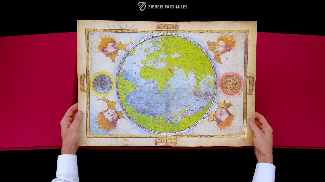
The Atlas Miller is a cartographical masterpiece that shows the geographical regions of the world as they were known in the Renaissance. The atlas was created in 1519, probably as a gift for the French King Francis I (1494-1547) on behalf of King Manuel I (1469-1521) of Portugal. It was the scientific and artistic result of the fertile collaboration between the leading cartographers Lopo Homem (ca. 1497 - ca. 1572), Pedro (ca. 1464 - after 1542) and Jorge Reinel (ca. 1502 - after 1572) as well as the gifted illuminator Antonio de Holanda (fl. first half of the 16th century). 10 detailed and fantastically illuminated maps of the magnificent atlas have been preserved, on which the depicted land areas in particular shine in rich colors and many golden details. Here, the traditions of portolan maps, Ptolemy's cosmographies and Flemish book illumination are artfully combined in a coherent Renaissance atlas.
Atlas Miller
The Atlas Miller is one of the most famous cartographical works in the Renaissance style. It originates from Portugal in 1519 at the behest of King Manuel I. The work arose from a collaboration of various artists and academics. The cartographers Lopo Homem as well as Pedro and Jorge Reinel prepared the geographic plans. The highly valuable illustrations of the maps were undertaken by the talented illuminator Antonio de Holanda. The work contains six sheets of vellum with a total of 10 zestfully decorated maps in various formats.
Exciting Geographic Depictions
The map, written in Latin and Portuguese, represents numerous geographic regions as they were known to Renaissance scholars. The North Atlantic, northern Europe, the archipelago of the Azores, Madagascar, the Indian Ocean, Indonesia, the West Pacific, the Maluku Islands, Brazil, and the Mediterranean are all depicted. The map of Brazil in particular, the *Terra Brasilis, is a truly masterful work of illuminated cartography**. The map shows countless depictions of people in activities typical of the country and the natural conditions of Brazil, as envisioned by those artists. Their depictions give evidence of their limitless creativity and great attention to detail.
A Royal Owner
The Atlas Miller was commissioned by King Manuel I of Portugal. The king set no financial limits on the cartographers and artists who produced the work. It is assumed that it was meant as a gift for the knight-king Francois I of France. The valuable work was acquired by the French National Library in Paris in 1897. It was formerly in the possession of the librarian Bénigne Emmanuel Clement Miller, from whom its present name originates.
Codicology
- Alternative Titles
- Atlante Miller
- Type
- Map on parchment
- Size / Format
- 6 leaves / 5 leaves: 59.0 × 41.5 cm; 1 leave: 117.0 × 61.0 cm
- Origin
- Portugal
- Date
- 1519
- Epochs
- Style
- Genre
- Language
- Illustrations
- Detailed and fantastical maps in vibrant colors and with extensive golden details
- Content
- 10 maps + 1 title
- Patron
- King Manuel I of Portugal (1469–1521)
- Artist / School
- Pedro and Jorge Reinel (cartographers)
Lopo Homem and António de Holanda (illuminators)
 / GE DD-683 (2-5 RES) / GE AA-640 (RES) – Bibliothèque nationale de France (Paris, France)")
Atlas Miller
Brazil
Although the Brazilian coastline is crammed with the names of various settlements and harbors, the vast unknown interior is left to the artist’s imagination. The artist has utilized countless shades of green to create a lush and verdant landscape. Aside from people, there are red and blue birds flying and perching in trees, crouching monkeys, and even a green dragon. Hunters with bows and arrows are shown dressed in colorful feathers while naked laborers collect and chop firewood.
 / GE DD-683 (2-5 RES) / GE AA-640 (RES) – Bibliothèque nationale de France (Paris, France)")
Atlas Miller
The Indian Ocean
This splendid double-page map artfully depicts the lands surrounding the Indian Ocean, which is teaming with ships whose sails carry both the cross of Christian merchants and the crescent moons of their Muslim colleagues. Many small islands are depicted with red and blue ink as well as gold and silver leaf. The Portuguese flag and coat of arms can be seen all over the map.
The eastern tip of Africa features a man riding on horseback at a gallop, the Arabian Peninsula shows a man dressed in blue with sword and shield, and India has bare-chested warriors with horned pink helmets. Various exotic animals including camels, a lion, a rhinoceros, and elephants are shown walking among palm forests, mountains, and important cities with tall towers.
 / GE DD-683 (2-5 RES) / GE AA-640 (RES) – Bibliothèque nationale de France (Paris, France)")
#1 Atlas Miller
Language: Spanish
(1,000€ - 3,000€)
")
")
")
")
 – Circulo Cientifico – CPL GE AA-564 (département Cartes et plans) – Bibliothèque nationale de France (Paris, France)")
- Treatises / Secular Books
- Apocalypses / Beatus
- Astronomy / Astrology
- Bestiaries
- Bibles / Gospels
- Chronicles / History / Law
- Geography / Maps
- Saints' Lives
- Islam / Oriental
- Judaism / Hebrew
- Single Leaf Collections
- Leonardo da Vinci
- Literature / Poetry
- Liturgical Manuscripts
- Medicine / Botany / Alchemy
- Music
- Mythology / Prophecies
- Psalters
- Other Religious Books
- Games / Hunting
- Private Devotion Books
- Other Genres
- Afghanistan
- Armenia
- Austria
- Belgium
- Belize
- Bosnia and Herzegovina
- China
- Colombia
- Costa Rica
- Croatia
- Cyprus
- Czech Republic
- Denmark
- Egypt
- El Salvador
- Ethiopia
- France
- Germany
- Greece
- Guatemala
- Honduras
- Hungary
- India
- Iran
- Iraq
- Israel
- Italy
- Japan
- Jordan
- Kazakhstan
- Kyrgyzstan
- Lebanon
- Liechtenstein
- Luxembourg
- Mexico
- Morocco
- Netherlands
- Palestine
- Panama
- Peru
- Poland
- Portugal
- Romania
- Russia
- Serbia
- Spain
- Sri Lanka
- Sweden
- Switzerland
- Syria
- Tajikistan
- Turkey
- Turkmenistan
- Ukraine
- United Kingdom
- United States
- Uzbekistan
- Vatican City
- A. Oosthoek, van Holkema & Warendorf
- Aboca Museum
- Ajuntament de Valencia
- Akademie Verlag
- Akademische Druck- u. Verlagsanstalt (ADEVA)
- Aldo Ausilio Editore - Bottega d’Erasmo
- Alecto Historical Editions
- Alkuin Verlag
- Almqvist & Wiksell
- Amilcare Pizzi
- Andreas & Andreas Verlagsbuchhandlung
- Archa 90
- Archiv Verlag
- Archivi Edizioni
- Arnold Verlag
- ARS
- Ars Magna
- Ars Millenii
- Art Market
- ArtCodex
- AyN Ediciones
- Azimuth Editions
- Badenia Verlag
- Bärenreiter-Verlag
- Belser Verlag
- Belser Verlag / WK Wertkontor
- Benziger Verlag
- Bernardinum Wydawnictwo
- BiblioGemma
- Biblioteca Apostolica Vaticana (Vaticanstadt, Vaticanstadt)
- Bibliotheca Palatina Faksimile Verlag
- Bibliotheca Rara
- Boydell & Brewer
- Bramante Edizioni
- Bredius Genootschap
- Brepols Publishers
- British Library
- Brokarte
- C. Weckesser
- Caixa Catalunya
- Canesi
- CAPSA, Ars Scriptoria
- Caratzas Brothers, Publishers
- Carus Verlag
- Casamassima Libri
- Centrum Cartographie Verlag GmbH
- Chavane Verlag
- Christian Brandstätter Verlag
- Circulo Cientifico
- Club Bibliófilo Versol
- Club du Livre
- Club Internacional del Libro
- CM Editores
- Collegium Graphicum
- Collezione Apocrifa Da Vinci
- Comissão Nacional para as Comemorações dos Descobrimentos Portugueses
- Coron Verlag
- Corvina
- CTHS
- D. S. Brewer
- Damon
- De Agostini/UTET
- De Nederlandsche Boekhandel
- De Schutter
- Deuschle & Stemmle
- Deutscher Verlag für Kunstwissenschaft
- DIAMM
- Dropmore Press
- Droz
- E. Schreiber Graphische Kunstanstalten
- Ediciones Boreal
- Ediciones Grial
- Ediclube
- Edições Inapa
- Edilan
- Editalia
- Edition Deuschle
- Edition Georg Popp
- Edition Leipzig
- Edition Libri Illustri
- Editiones Reales Sitios S. L.
- Éditions de l'Oiseau Lyre
- Editions Medicina Rara
- Editorial Casariego
- Editorial Mintzoa
- Editrice Antenore
- Editrice Velar
- Edizioni Edison
- Egeria, S.L.
- Eikon Editores
- Electa
- Emery Walker Limited
- Enciclopèdia Catalana
- Eos-Verlag
- Ephesus Publishing
- Ernst Battenberg
- Eugrammia Press
- Extraordinary Editions
- Fackelverlag
- Facsimila Art & Edition
- Facsimile Editions Ltd.
- Facsimilia Art & Edition Ebert KG
- Faksimile Verlag
- Feuermann Verlag
- Folger Shakespeare Library
- Franco Cosimo Panini Editore
- Friedrich Wittig Verlag
- Fundación Hullera Vasco-Leonesa
- G. Braziller
- Gabriele Mazzotta Editore
- Gebr. Mann Verlag
- Gesellschaft für graphische Industrie
- Getty Research Institute
- Giovanni Domenico de Rossi
- Giunti Editore
- Goldenmark Librarium
- Graffiti
- Grafica European Center of Fine Arts
- Guido Pressler
- Guillermo Blazquez
- Gustav Kiepenheuer
- H. N. Abrams
- Harrassowitz
- Harvard University Press
- Helikon
- Hendrickson Publishers
- Henning Oppermann
- Herder Verlag
- Hes & De Graaf Publishers
- Hoepli
- Holbein-Verlag
- Houghton Library
- Hugo Schmidt Verlag
- Hungarian Academy of Sciences
- Idion Verlag
- Il Bulino, edizioni d'arte
- ILte
- Imago
- Insel Verlag
- Insel-Verlag Anton Kippenberger
- Instituto de Estudios Altoaragoneses
- Instituto Nacional de Antropología e Historia
- Introligatornia Budnik Jerzy
- Istituto dell'Enciclopedia Italiana - Treccani
- Istituto Ellenico di Studi Bizantini e Postbizantini
- Istituto Geografico De Agostini
- Istituto Poligrafico e Zecca dello Stato
- Italarte Art Establishments
- Jaca Book
- Jan Thorbecke Verlag
- Johnson Reprint Corporation
- Johnson Reprint Corporation
- Jos. Baer
- Josef Stocker
- Josef Stocker-Schmid
- Jugoslavija
- Karl W. Hiersemann
- Kasper Straube
- Kaydeda Ediciones
- Kindler Verlag / Coron Verlag
- Kodansha International Ltd.
- Konrad Kölbl Verlag
- Kurt Wolff Verlag
- La Liberia dello Stato
- La Linea Editrice
- La Meta Editore
- Lambert Schneider
- Landeskreditbank Baden-Württemberg
- Leo S. Olschki
- Les Incunables
- Liber Artis
- Library of Congress
- Libreria Musicale Italiana
- Lichtdruck
- Lito Immagine Editore
- Lumen Artis
- Lund Humphries
- M. Moleiro Editor
- Maison des Sciences de l'homme et de la société de Poitiers
- Manuscriptum
- Martinus Nijhoff
- Maruzen-Yushodo Co. Ltd.
- MASA
- Massada Publishers
- McGraw-Hill
- Metropolitan Museum of Art
- Militos
- Millennium Liber
- Müller & Schindler
- Nahar - Stavit
- Nahar and Steimatzky
- National Library of Wales
- Neri Pozza
- Nova Charta
- Oceanum Verlag
- Odeon
- Omnia Arte
- Orbis Mediaevalis
- Orbis Pictus
- Österreichische Staatsdruckerei
- Oxford University Press
- Pageant Books
- Parzellers Buchverlag
- Patrimonio Ediciones
- Pattloch Verlag
- PIAF
- Pieper Verlag
- Plon-Nourrit et cie
- Poligrafiche Bolis
- Presses Universitaires de Strasbourg
- Prestel Verlag
- Princeton University Press
- Prisma Verlag
- Priuli & Verlucca, editori
- Pro Sport Verlag
- Propyläen Verlag
- Pytheas Books
- Quaternio Verlag Luzern
- Reales Sitios
- Recht-Verlag
- Reichert Verlag
- Reichsdruckerei
- Reprint Verlag
- Riehn & Reusch
- Roberto Vattori Editore
- Rosenkilde and Bagger
- Roxburghe Club
- Salerno Editrice
- Saltellus Press
- Sandoz
- Sarajevo Svjetlost
- Schöck ArtPrint Kft.
- Schulsinger Brothers
- Scolar Press
- Scrinium
- Scripta Maneant
- Scriptorium
- Shazar
- Siloé, arte y bibliofilia
- SISMEL - Edizioni del Galluzzo
- Sociedad Mexicana de Antropología
- Société des Bibliophiles & Iconophiles de Belgique
- Soncin Publishing
- Sorli Ediciones
- Stainer and Bell
- Studer
- Styria Verlag
- Sumptibus Pragopress
- Szegedi Tudomànyegyetem
- Taberna Libraria
- Tarshish Books
- Taschen
- Tempus Libri
- Testimonio Compañía Editorial
- TGB Limited Editions
- Thames and Hudson
- The Clear Vue Publishing Partnership Limited
- The Facsimile Codex
- The Folio Society
- The Marquess of Normanby
- The Orphan Hospital Ward of Israel
- The Richard III and Yorkist History Trust
- The Warburg Institute
- Tip.Le.Co
- TouchArt
- TREC Publishing House
- TRI Publishing Co.
- Trident Editore
- Tuliba Collection
- Typis Regiae Officinae Polygraphicae
- Union Verlag Berlin
- Universidad de Granada
- Universitaire Bibliotheken Leiden
- University of California Press
- University of Chicago Press
- Urs Graf
- Vallecchi
- Van Wijnen
- VCH, Acta Humaniora
- VDI Verlag
- VEB Deutscher Verlag für Musik
- Verein Schweizerischer Lithographie-Besitzer
- Verlag Anton Pustet / Andreas Verlag
- Verlag Bibliophile Drucke Josef Stocker
- Verlag der Münchner Drucke
- Verlag für Regionalgeschichte
- Verlag Styria
- Vicent Garcia Editores
- W. Turnowsky
- Waanders Printers
- Wiener Mechitharisten-Congregation (Wien, Österreich)
- Wissenschaftliche Buchgesellschaft
- Wissenschaftliche Verlagsgesellschaft
- Wydawnictwo Dolnoslaskie
- Xuntanza Editorial
- Zakład Narodowy
- Zollikofer AG