The First Circumnavigation of the World (Collection)
 – Circulo Cientifico – CPL GE AA-564 (département Cartes et plans) – Bibliothèque nationale de France (Paris, France)")
Spain — Before 1522
The records of a historical project in the history of mankind: maps, letters, and other documents related to the first circumnavigation of the world by Magellan from archives and libraries all over Europe
Ferdinand Magellan (1480-1521) attempted to sail around the world beginning in 1519
After his death, Juan Sebastián Elcano (ca. 1476-1526) completed the voyage in 1522
These documents, including splendid maps, give intimate insights into the famous expedition
The First Circumnavigation of the World (Collection)

 – Circulo Cientifico – CPL GE AA-564 (département Cartes et plans) – Bibliothèque nationale de France (Paris, France)")
 – Circulo Cientifico – CPL GE AA-564 (département Cartes et plans) – Bibliothèque nationale de France (Paris, France)")
 – Circulo Cientifico – CPL GE AA-564 (département Cartes et plans) – Bibliothèque nationale de France (Paris, France)")
 – Circulo Cientifico – CPL GE AA-564 (département Cartes et plans) – Bibliothèque nationale de France (Paris, France)")
 – Circulo Cientifico – CPL GE AA-564 (département Cartes et plans) – Bibliothèque nationale de France (Paris, France)")
 – Circulo Cientifico – CPL GE AA-564 (département Cartes et plans) – Bibliothèque nationale de France (Paris, France)")
 – Circulo Cientifico – CPL GE AA-564 (département Cartes et plans) – Bibliothèque nationale de France (Paris, France)")
 – Circulo Cientifico – CPL GE AA-564 (département Cartes et plans) – Bibliothèque nationale de France (Paris, France)")
 – Circulo Cientifico – CPL GE AA-564 (département Cartes et plans) – Bibliothèque nationale de France (Paris, France)")
 – Circulo Cientifico – CPL GE AA-564 (département Cartes et plans) – Bibliothèque nationale de France (Paris, France)")
 – Circulo Cientifico – CPL GE AA-564 (département Cartes et plans) – Bibliothèque nationale de France (Paris, France)")
 – Circulo Cientifico – CPL GE AA-564 (département Cartes et plans) – Bibliothèque nationale de France (Paris, France)")
 – Circulo Cientifico – CPL GE AA-564 (département Cartes et plans) – Bibliothèque nationale de France (Paris, France)")
 – Circulo Cientifico – CPL GE AA-564 (département Cartes et plans) – Bibliothèque nationale de France (Paris, France)")
 – Circulo Cientifico – CPL GE AA-564 (département Cartes et plans) – Bibliothèque nationale de France (Paris, France)")
 – Circulo Cientifico – CPL GE AA-564 (département Cartes et plans) – Bibliothèque nationale de France (Paris, France)")
 – Circulo Cientifico – CPL GE AA-564 (département Cartes et plans) – Bibliothèque nationale de France (Paris, France)")
 – Circulo Cientifico – CPL GE AA-564 (département Cartes et plans) – Bibliothèque nationale de France (Paris, France)")
(1,000€ - 3,000€)
The first circumnavigation of the globe was an ambitious project that would claim the life of the visionary who made it happen, Ferdinand Magellan (1480-1521). Under the command of Juan Sebastián Elcano (ca. 1476-1526), his men nevertheless completed his historic mission without him, which had begun with a crew of 270 men on five ships on September 20, 1519 in Sanlúcar de Barrameda in Andalusia and ended on September 6, 1522 with a single ship, the Victoria. She returned to Spain with a skeleton crew of just 18 men who had endured incredible hardship to make history and save their lives. After this milestone of navigation, the age of exploration and colonization began. The European race for trade routes to the riches of the East was kicked off. This historic voyage is attested to in the stunning maps and first-hand historical documents presented in the compendium at hand.
The First Circumnavigation of the World (Collection)
A journey that would change the history of the world: 270 men and five ships left Spain on September 20th, 1519 seeking a westward sea route around the globe. On September 6th, 1522 a single ship, the Victoria, returned with a skeleton crew of only 18 men who had endured incredible hardships in order to make history. Under the leadership of the Portuguese sea voyager Ferdinand Magellan (1480–1521), they successfully completed the voyage even after Magellan’s death during the voyage. This historic voyage is attested to in the gorgeous maps and firsthand historical documents presented in the compendium at hand.
The Death of the Commander and a Happy Ending
With the discovery of the Straits of Magellan, a connection to the Pacific in South America, the first hurdle was cleared. In trying to find another way to the Spice Islands, Magellan was killed in battle in the modern Philippines. The undertaking was eventually completed successfully under Juan Sebastián Elcano (ca. 1476–1526). With a single ship – fully-loaded with spices – the expedition returned to Spain via the Portuguese route. Of the 270 men who originally set out on the onerous journey, only 18 men returned on the 7th of September 1522. This exciting chapter in world history – from its beginnings, to its tragic events, to its happy conclusion – can now be thoroughly studied with the help of the documents collected here!
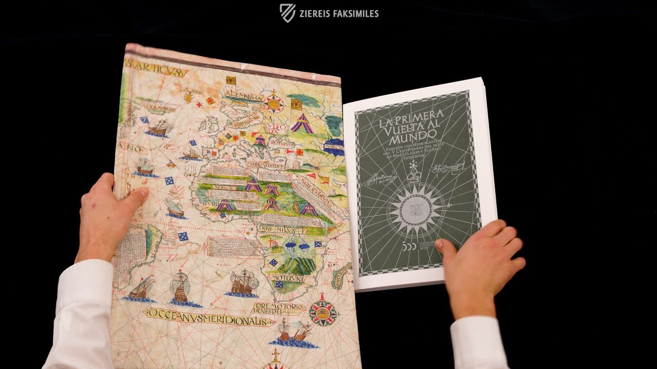
Portulano de Jorge Reinel
Dated 1530, the world map in this collection shows Spanish carracks and Arabian tents, mountains, rivers, and detailed coastlines. It was created by Jorge Reinel (ca. 1502 – after 1572), a Portuguese cartographer and part of the group responsible for making the maps that would be used on Magellan’s expedition. The son of another famous cartographer, Pedro Reinel, Jorge went on to mentor many pupils himself including Diogo Ribeiro. The map in this collection represents the cutting edge of cartography in the early 16th century and is a gorgeous, imaginative fusion of art and science. This particular portolan chart is extremely accurate, possibly created with spherical trigonometry, and was useful for measuring the distance between Seville and the Maluccas, also known as the Spice Islands for their plentiful nutmeg, cloves, and other coveted seasonings. It artfully illustrates the route taken for the first circumnavigation of the globe and was created to commemorate the achievement, of which Jorge Reinel had been a part by giving the navigators the tools they needed to find their way around the world.
The collection contains the following documents:
- Paris, Bibliothèque Nationale de France, Ge AA-564 (RES) — Portulano de Jorge Reinel;
- Seville, Archivo General de Indias, Patronato, 34, r. 7 — Capitulaciones del Viaje;
- Seville, Archivo General de Indias, Patronato, 34, r. 2 — Carta de Magallanes al Rey Carlos I;
- Seville, Archivo General de Indias, Patronato, 34, r. 6 — Rol de la Armada;
- Seville, Archivo General de Indias, Patronato, 24, r. 11 — Memoria de las personas que fallecieron en la Armada;
- Seville, Archivo General de Indias, Patronato, 48, r. 20 — Carta de Elcano al Rey Carlos I;
- Archivo de la Torre de Laurgaín. Sección Laurgaín, legajo 15, nº 9 Euskadiko Artxibo Historikoa - Archivo Histórico de Euskadi; Fondos familiares — Carta de Elcano al Rey Carlos I.
Codicology
- Alternative Titles
- La Primera Vuelta al Mundo
Die erste Weltumsegelung - Size / Format
- 1 map, 6 documents / Map: 65.0 × 124.0 cm
- Origin
- Spain
- Date
- Before 1522
- Epochs
- Style
- Language
- Illustrations
- The map was illuminated with many colorful details and gold
- Content
- Different maps and documents
- Artist / School
- Jorge Reinel
Ferdinand Magellan
Juan Sebastián Elcano
 – Circulo Cientifico – CPL GE AA-564 (département Cartes et plans) – Bibliothèque nationale de France (Paris, France)")
The First Circumnavigation of the World (Collection)
Shipwreck!
Although known today as the Cape of Good Hope, the southern tip of Africa has had other, more appropriately descriptive names for the treacherous, shark-infested waters that connect the Atlantic and Indian Oceans including the Cabo das Tormentas or “Cape of Storms”. This shipwreck is depicted in these dangerous waters: its main mast has snapped with its ragged sail fluttering in the wind and the ship itself appears to have been broken into two pieces, perhaps after striking a rock.
 – Circulo Cientifico – CPL GE AA-564 (département Cartes et plans) – Bibliothèque nationale de France (Paris, France)")
The First Circumnavigation of the World (Collection)
Portulano de Jorge Reinel
This world map from the year 1519 is attributed to the Portuguese cartographer Jorge Reinel, who was active in Seville at the time. Aside from typical geographic features and various sailing ships, it contains numerous legends in Latin and the location of the Molucca Islands in the far west, which indicates that this is one of the maps used by Magellan to convince the Spanish crown to support his expedition.
It is also believed that Magellan gave King Charles I of Spain (the future Holy Roman Emperor Charles V) a painted globe that corresponds to this magnificent portolan chart. The original map went missing from the Bayerische Armeebibliothek in Munich sometime during World War II and today only a copy made by Otto Progel in 1836 survives.
 – Circulo Cientifico – CPL GE AA-564 (département Cartes et plans) – Bibliothèque nationale de France (Paris, France)")
#1 La Primera Vuelta al Mundo
Language: Spanish
The commentary volume includes several studies by renowned experts.
(1,000€ - 3,000€)
")
")
")
")
 – Ediciones Grial – MS 351 – Beinecke Rare Book and Manuscript Library (New Haven, USA)")
 – Taberna Libraria – Patronato, 34, R.10 – Archivo General de Indias (Seville, Spain)")
- Treatises / Secular Books
- Apocalypses / Beatus
- Astronomy / Astrology
- Bestiaries
- Bibles / Gospels
- Chronicles / History / Law
- Geography / Maps
- Saints' Lives
- Islam / Oriental
- Judaism / Hebrew
- Single Leaf Collections
- Leonardo da Vinci
- Literature / Poetry
- Liturgical Manuscripts
- Medicine / Botany / Alchemy
- Music
- Mythology / Prophecies
- Psalters
- Other Religious Books
- Games / Hunting
- Private Devotion Books
- Other Genres
- Afghanistan
- Armenia
- Austria
- Belgium
- Belize
- Bosnia and Herzegovina
- China
- Colombia
- Costa Rica
- Croatia
- Cyprus
- Czech Republic
- Denmark
- Egypt
- El Salvador
- Ethiopia
- France
- Germany
- Greece
- Guatemala
- Honduras
- Hungary
- India
- Iran
- Iraq
- Israel
- Italy
- Japan
- Jordan
- Kazakhstan
- Kyrgyzstan
- Lebanon
- Liechtenstein
- Luxembourg
- Mexico
- Morocco
- Netherlands
- Palestine
- Panama
- Peru
- Poland
- Portugal
- Romania
- Russia
- Serbia
- Spain
- Sri Lanka
- Sweden
- Switzerland
- Syria
- Tajikistan
- Turkey
- Turkmenistan
- Ukraine
- United Kingdom
- United States
- Uzbekistan
- Vatican City
- A. Oosthoek, van Holkema & Warendorf
- Aboca Museum
- Ajuntament de Valencia
- Akademie Verlag
- Akademische Druck- u. Verlagsanstalt (ADEVA)
- Aldo Ausilio Editore - Bottega d’Erasmo
- Alecto Historical Editions
- Alkuin Verlag
- Almqvist & Wiksell
- Amilcare Pizzi
- Andreas & Andreas Verlagsbuchhandlung
- Archa 90
- Archiv Verlag
- Archivi Edizioni
- Arnold Verlag
- ARS
- Ars Magna
- Ars Millenii
- Art Market
- ArtCodex
- AyN Ediciones
- Azimuth Editions
- Badenia Verlag
- Bärenreiter-Verlag
- Belser Verlag
- Belser Verlag / WK Wertkontor
- Benziger Verlag
- Bernardinum Wydawnictwo
- BiblioGemma
- Biblioteca Apostolica Vaticana (Vaticanstadt, Vaticanstadt)
- Bibliotheca Palatina Faksimile Verlag
- Bibliotheca Rara
- Boydell & Brewer
- Bramante Edizioni
- Bredius Genootschap
- Brepols Publishers
- British Library
- Brokarte
- C. Weckesser
- Caixa Catalunya
- Canesi
- CAPSA, Ars Scriptoria
- Caratzas Brothers, Publishers
- Carus Verlag
- Casamassima Libri
- Centrum Cartographie Verlag GmbH
- Chavane Verlag
- Christian Brandstätter Verlag
- Circulo Cientifico
- Club Bibliófilo Versol
- Club du Livre
- Club Internacional del Libro
- CM Editores
- Collegium Graphicum
- Collezione Apocrifa Da Vinci
- Comissão Nacional para as Comemorações dos Descobrimentos Portugueses
- Coron Verlag
- Corvina
- CTHS
- D. S. Brewer
- Damon
- De Agostini/UTET
- De Nederlandsche Boekhandel
- De Schutter
- Deuschle & Stemmle
- Deutscher Verlag für Kunstwissenschaft
- DIAMM
- Dropmore Press
- Droz
- E. Schreiber Graphische Kunstanstalten
- Ediciones Boreal
- Ediciones Grial
- Ediclube
- Edições Inapa
- Edilan
- Editalia
- Edition Deuschle
- Edition Georg Popp
- Edition Leipzig
- Edition Libri Illustri
- Editiones Reales Sitios S. L.
- Éditions de l'Oiseau Lyre
- Editions Medicina Rara
- Editorial Casariego
- Editorial Mintzoa
- Editrice Antenore
- Editrice Velar
- Edizioni Edison
- Egeria, S.L.
- Eikon Editores
- Electa
- Emery Walker Limited
- Enciclopèdia Catalana
- Eos-Verlag
- Ephesus Publishing
- Ernst Battenberg
- Eugrammia Press
- Extraordinary Editions
- Fackelverlag
- Facsimila Art & Edition
- Facsimile Editions Ltd.
- Facsimilia Art & Edition Ebert KG
- Faksimile Verlag
- Feuermann Verlag
- Folger Shakespeare Library
- Franco Cosimo Panini Editore
- Friedrich Wittig Verlag
- Fundación Hullera Vasco-Leonesa
- G. Braziller
- Gabriele Mazzotta Editore
- Gebr. Mann Verlag
- Gesellschaft für graphische Industrie
- Getty Research Institute
- Giovanni Domenico de Rossi
- Giunti Editore
- Goldenmark Librarium
- Graffiti
- Grafica European Center of Fine Arts
- Guido Pressler
- Guillermo Blazquez
- Gustav Kiepenheuer
- H. N. Abrams
- Harrassowitz
- Harvard University Press
- Helikon
- Hendrickson Publishers
- Henning Oppermann
- Herder Verlag
- Hes & De Graaf Publishers
- Hoepli
- Holbein-Verlag
- Houghton Library
- Hugo Schmidt Verlag
- Hungarian Academy of Sciences
- Idion Verlag
- Il Bulino, edizioni d'arte
- ILte
- Imago
- Insel Verlag
- Insel-Verlag Anton Kippenberger
- Instituto de Estudios Altoaragoneses
- Instituto Nacional de Antropología e Historia
- Introligatornia Budnik Jerzy
- Istituto dell'Enciclopedia Italiana - Treccani
- Istituto Ellenico di Studi Bizantini e Postbizantini
- Istituto Geografico De Agostini
- Istituto Poligrafico e Zecca dello Stato
- Italarte Art Establishments
- Jaca Book
- Jan Thorbecke Verlag
- Johnson Reprint Corporation
- Johnson Reprint Corporation
- Jos. Baer
- Josef Stocker
- Josef Stocker-Schmid
- Jugoslavija
- Karl W. Hiersemann
- Kasper Straube
- Kaydeda Ediciones
- Kindler Verlag / Coron Verlag
- Kodansha International Ltd.
- Konrad Kölbl Verlag
- Kurt Wolff Verlag
- La Liberia dello Stato
- La Linea Editrice
- La Meta Editore
- Lambert Schneider
- Landeskreditbank Baden-Württemberg
- Leo S. Olschki
- Les Incunables
- Liber Artis
- Library of Congress
- Libreria Musicale Italiana
- Lichtdruck
- Lito Immagine Editore
- Lumen Artis
- Lund Humphries
- M. Moleiro Editor
- Maison des Sciences de l'homme et de la société de Poitiers
- Manuscriptum
- Martinus Nijhoff
- Maruzen-Yushodo Co. Ltd.
- MASA
- Massada Publishers
- McGraw-Hill
- Metropolitan Museum of Art
- Militos
- Millennium Liber
- Müller & Schindler
- Nahar - Stavit
- Nahar and Steimatzky
- National Library of Wales
- Neri Pozza
- Nova Charta
- Oceanum Verlag
- Odeon
- Omnia Arte
- Orbis Mediaevalis
- Orbis Pictus
- Österreichische Staatsdruckerei
- Oxford University Press
- Pageant Books
- Parzellers Buchverlag
- Patrimonio Ediciones
- Pattloch Verlag
- PIAF
- Pieper Verlag
- Plon-Nourrit et cie
- Poligrafiche Bolis
- Presses Universitaires de Strasbourg
- Prestel Verlag
- Princeton University Press
- Prisma Verlag
- Priuli & Verlucca, editori
- Pro Sport Verlag
- Propyläen Verlag
- Pytheas Books
- Quaternio Verlag Luzern
- Reales Sitios
- Recht-Verlag
- Reichert Verlag
- Reichsdruckerei
- Reprint Verlag
- Riehn & Reusch
- Roberto Vattori Editore
- Rosenkilde and Bagger
- Roxburghe Club
- Salerno Editrice
- Saltellus Press
- Sandoz
- Sarajevo Svjetlost
- Schöck ArtPrint Kft.
- Schulsinger Brothers
- Scolar Press
- Scrinium
- Scripta Maneant
- Scriptorium
- Shazar
- Siloé, arte y bibliofilia
- SISMEL - Edizioni del Galluzzo
- Sociedad Mexicana de Antropología
- Société des Bibliophiles & Iconophiles de Belgique
- Soncin Publishing
- Sorli Ediciones
- Stainer and Bell
- Studer
- Styria Verlag
- Sumptibus Pragopress
- Szegedi Tudomànyegyetem
- Taberna Libraria
- Tarshish Books
- Taschen
- Tempus Libri
- Testimonio Compañía Editorial
- TGB Limited Editions
- Thames and Hudson
- The Clear Vue Publishing Partnership Limited
- The Facsimile Codex
- The Folio Society
- The Marquess of Normanby
- The Orphan Hospital Ward of Israel
- The Richard III and Yorkist History Trust
- The Warburg Institute
- Tip.Le.Co
- TouchArt
- TREC Publishing House
- TRI Publishing Co.
- Trident Editore
- Tuliba Collection
- Typis Regiae Officinae Polygraphicae
- Union Verlag Berlin
- Universidad de Granada
- Universitaire Bibliotheken Leiden
- University of California Press
- University of Chicago Press
- Urs Graf
- Vallecchi
- Van Wijnen
- VCH, Acta Humaniora
- VDI Verlag
- VEB Deutscher Verlag für Musik
- Verein Schweizerischer Lithographie-Besitzer
- Verlag Anton Pustet / Andreas Verlag
- Verlag Bibliophile Drucke Josef Stocker
- Verlag der Münchner Drucke
- Verlag für Regionalgeschichte
- Verlag Styria
- Vicent Garcia Editores
- W. Turnowsky
- Waanders Printers
- Wiener Mechitharisten-Congregation (Wien, Österreich)
- Wissenschaftliche Buchgesellschaft
- Wissenschaftliche Verlagsgesellschaft
- Wydawnictwo Dolnoslaskie
- Xuntanza Editorial
- Zakład Narodowy
- Zollikofer AG