Cantino's Map
")
Lisbon (Portugal) — 1502
Valuable contraband from a spy at the Portuguese court: an exact copy of the famous, once-secret world map known as the “Royal Standard,” featuring the newly charted coastline of Brazil, made for the Duke of Ferrara
Alberto Cantino was a spy for the Duke of Ferrara at the court of the Portuguese King Emanuel the Fortunate (1469–1521)
The map he smuggled is a superb specimen describing the state of Portuguese discoveries ca. 1500
It is believed to be an exact copy of a secret "Royal Standard", notable for depicting the Brazilian coast
Cantino's Map

")
")
")
")
")
")
")
")
")
")
")
")
")
")
")
")
(1,000€ - 3,000€)
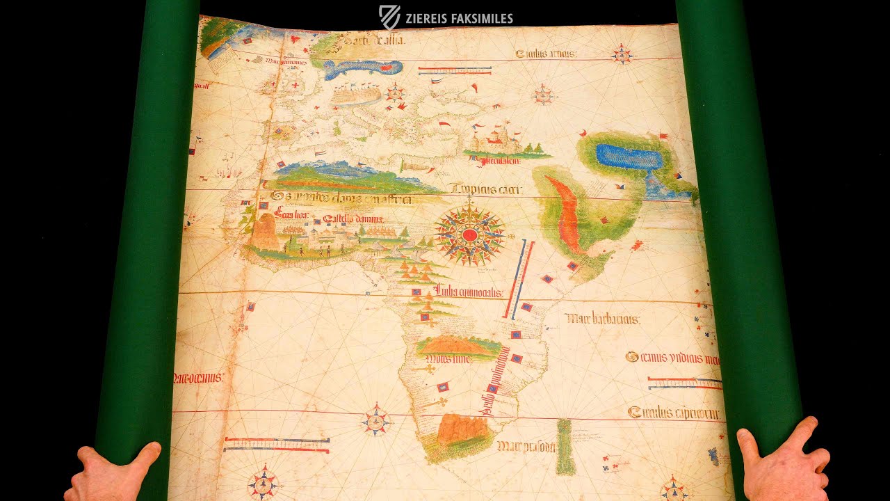
Created in Portugal in 1502, the so-called Cantino’s Map is probably a secret copy of the map known as the “Royal Standard,” which was intended to be accessible only to the highest circles of the Portuguese court. It reflects the state of Portuguese discoveries around 1500 and already depicts relatively large parts of the American continent—an exceptional advantage in terms of geographical knowledge at the time. Cantino’s Map is named after Alberto Cantino, an Italian spy who served as a “diplomat” for the Duke of Ferrara, Ercole I d’Este (1431–1505), at the court of the Portuguese king Manuel the Fortunate (1469–1521). Cantino succeeded in smuggling the important map—or rather an exact copy—from Portugal to Italy and presenting his duke with the new geographical knowledge gathered by Portuguese navigators such as Pedro Álvares Cabral, Amerigo Vespucci, Christopher Columbus, and Vasco da Gama.
Cantino's Map
Portuguese seafaring was advancing worldwide in the 15th century. No other country could record as many discoveries and successful expeditions as Portugal. The Kingdom of Portugal was among the most important colonial powers worldwide. In the course of the numerous discoveries of unknown lands and new geographic regions, the most important cartography school in Europe developed in Portugal. The masterful Cantino’s Map outstandingly illustrates the state of Portuguese discoveries ca. 1500. The hand-drawn maps show the landmasses known at that time and is illustrated by vividly colored decorative elements.
The Spy Alberto Cantino
Alberto Cantino was officially a diplomat of the Italian trading house of Duke Ercole I d’Este of Ferrara at the court of the Portuguese King Emanuel the Fortunate. Unofficially, Cantino’s primary objective above all else was the procurement of information regarding the Portuguese discoveries and expeditions. Thus he reported about the Gaspar Corte-Real, whose voyage of discovery abducted people and hauled them back to Portugal. In this regard, two letters to the Duke from the 17th and 18th of October, 1501 still survive. The spy was made famous for the map that bears his name. In the year 1502, he managed to smuggle the Portuguese map into Italy for the Duke of Ferrara.
A Special Map
The world map by Alberto Cantino is considered to be particularly noteworthy, because it illustrates a part of the Brazilian coast. This was discovered by the Portuguese seafarer Pedro Álvares Cabral ca. 1500. He postulated that he had discovered a new continent previously unknown to Europeans. It was first confirmed later, that this was a part of the same continent, which various Spanish explorers, e.g. Amerigo Vespucci, had already discovered farther to the north. Beyond that, the maps contained findings from the journeys of Christopher Columbus in the Caribbean, of Vasco de Gama and later Pedro Álvares Cabal to East Africa and India, as well as Gaspar Corte-Real and Miguel Corte-Real to Greenland and Newfoundland. The map documents the great deeds of the Portuguese explorers in the finest detail.
The Turbulent History of the Splendid Map
It is assumed that Cantino’s Map is an exact copy of a world map, which is designated with the title Royal Standard and which was kept secret from the public. It is also assumed that Cantino was able to bribe one of the Portuguese cartographers into making him a copy. The map provided the Italian with knowledge of the Brazilian coast, and this part of South America therewith, long before other nations generally became aware that South America stretched itself far southward. This map probably served as an important source for the world-famous Waldseemüller Map of 1507, the first world atlas ever.
Codicology
- Alternative Titles
- La Carta del Cantino
Cantino-Weltkarte
Cantino-Planisphäre
Charta del navicare del Cantino
Cantino's World Map
Planisfero di Cantino
Cantino Planisphere
Planisfero del Cantino
Cantino Map - Type
- Map on parchment
- Size / Format
- 1 map / 220.0 × 105.0 cm
- Origin
- Portugal
- Date
- 1502
- Epochs
- Style
- Genre
- Language
- Script
- Gothic Textura Quadrata
- Illustrations
- Colorful illumination of topographical features and coastlines
- Content
- Map with the Portuguese discoveries at the time around 1500
- Patron
- Alberto Cantino
- Previous Owners
- Estense Court of Ferrara
")
Cantino's Map
Venice
Most of the cities are only indicated by their written names on Cantino's Map. The exceptions are therefore all the more striking. As usual, Jerusalem is highlighted by a large depiction of the city. In North Africa, the Tower of Babel and the important Portuguese trading post Elmina Castle ("Castello damina") in the Gulf of Guinea also appear. As one of the most important trading metropolises in the Mediterranean region, Venice is also included in this list, appearing oversized north of the Adriatic with many high towers and seemingly endless arcades.
")
Cantino's Map
Tordesillas Line
With the Treaty of Tordesillas of June 7, 1494, the rule over the Atlantic Ocean was settled between the kingdoms of Portugal and Castile. Both kingdoms had a great interest in reaching Asia via the Atlantic – either via the route around the African continent or via the route to the west. A line of demarcation was established, which was to run along a meridian 370 "Léguas" (c. 1418 miles) west of the westernmost Cape Verde Islands.
It is clearly marked in blue on the map. While the Castilian Crown's territory lies to the west, the part of the Atlantic to the east of the line belongs to the "Terra del Rey de Portugall" – including various Atlantic islands, parts of present-day Brazil, which is populated by giant parrots, and the forested Newfoundland in the north. It is one of the oldest cartographic representations of the North American island.
")
#1 La Carta del Cantino
Languages: Italian, English
(1,000€ - 3,000€)
 – National Library of Russia (St. Petersburg, Russia)")
")
")
")
")
- Treatises / Secular Books
- Apocalypses / Beatus
- Astronomy / Astrology
- Bestiaries
- Bibles / Gospels
- Chronicles / History / Law
- Geography / Maps
- Saints' Lives
- Islam / Oriental
- Judaism / Hebrew
- Single Leaf Collections
- Leonardo da Vinci
- Literature / Poetry
- Liturgical Manuscripts
- Medicine / Botany / Alchemy
- Music
- Mythology / Prophecies
- Psalters
- Other Religious Books
- Games / Hunting
- Private Devotion Books
- Other Genres
- Afghanistan
- Armenia
- Austria
- Belgium
- Belize
- Bosnia and Herzegovina
- China
- Colombia
- Costa Rica
- Croatia
- Cyprus
- Czech Republic
- Denmark
- Egypt
- El Salvador
- Ethiopia
- France
- Germany
- Greece
- Guatemala
- Honduras
- Hungary
- India
- Iran
- Iraq
- Israel
- Italy
- Japan
- Jordan
- Kazakhstan
- Kyrgyzstan
- Lebanon
- Liechtenstein
- Luxembourg
- Mexico
- Morocco
- Netherlands
- Palestine
- Panama
- Peru
- Poland
- Portugal
- Romania
- Russia
- Serbia
- Spain
- Sri Lanka
- Sweden
- Switzerland
- Syria
- Tajikistan
- Turkey
- Turkmenistan
- Ukraine
- United Kingdom
- United States
- Uzbekistan
- Vatican City
- A. Oosthoek, van Holkema & Warendorf
- Aboca Museum
- Ajuntament de Valencia
- Akademie Verlag
- Akademische Druck- u. Verlagsanstalt (ADEVA)
- Aldo Ausilio Editore - Bottega d’Erasmo
- Alecto Historical Editions
- Alkuin Verlag
- Almqvist & Wiksell
- Amilcare Pizzi
- Andreas & Andreas Verlagsbuchhandlung
- Archa 90
- Archiv Verlag
- Archivi Edizioni
- Arnold Verlag
- ARS
- Ars Magna
- Ars Millenii
- Art Market
- ArtCodex
- AyN Ediciones
- Azimuth Editions
- Badenia Verlag
- Bärenreiter-Verlag
- Belser Verlag
- Belser Verlag / WK Wertkontor
- Benziger Verlag
- Bernardinum Wydawnictwo
- BiblioGemma
- Biblioteca Apostolica Vaticana (Vaticanstadt, Vaticanstadt)
- Bibliotheca Palatina Faksimile Verlag
- Bibliotheca Rara
- Boydell & Brewer
- Bramante Edizioni
- Bredius Genootschap
- Brepols Publishers
- British Library
- Brokarte
- C. Weckesser
- Caixa Catalunya
- Canesi
- CAPSA, Ars Scriptoria
- Caratzas Brothers, Publishers
- Carus Verlag
- Casamassima Libri
- Centrum Cartographie Verlag GmbH
- Chavane Verlag
- Christian Brandstätter Verlag
- Circulo Cientifico
- Club Bibliófilo Versol
- Club du Livre
- Club Internacional del Libro
- CM Editores
- Collegium Graphicum
- Collezione Apocrifa Da Vinci
- Comissão Nacional para as Comemorações dos Descobrimentos Portugueses
- Coron Verlag
- Corvina
- CTHS
- D. S. Brewer
- Damon
- De Agostini/UTET
- De Nederlandsche Boekhandel
- De Schutter
- Deuschle & Stemmle
- Deutscher Verlag für Kunstwissenschaft
- DIAMM
- Dropmore Press
- Droz
- E. Schreiber Graphische Kunstanstalten
- Ediciones Boreal
- Ediciones Grial
- Ediclube
- Edições Inapa
- Edilan
- Editalia
- Edition Deuschle
- Edition Georg Popp
- Edition Leipzig
- Edition Libri Illustri
- Editiones Reales Sitios S. L.
- Éditions de l'Oiseau Lyre
- Editions Medicina Rara
- Editorial Casariego
- Editorial Mintzoa
- Editrice Antenore
- Editrice Velar
- Edizioni Edison
- Egeria, S.L.
- Eikon Editores
- Electa
- Emery Walker Limited
- Enciclopèdia Catalana
- Eos-Verlag
- Ephesus Publishing
- Ernst Battenberg
- Eugrammia Press
- Extraordinary Editions
- Fackelverlag
- Facsimila Art & Edition
- Facsimile Editions Ltd.
- Facsimilia Art & Edition Ebert KG
- Faksimile Verlag
- Feuermann Verlag
- Folger Shakespeare Library
- Franco Cosimo Panini Editore
- Friedrich Wittig Verlag
- Fundación Hullera Vasco-Leonesa
- G. Braziller
- Gabriele Mazzotta Editore
- Gebr. Mann Verlag
- Gesellschaft für graphische Industrie
- Getty Research Institute
- Giovanni Domenico de Rossi
- Giunti Editore
- Goldenmark Librarium
- Graffiti
- Grafica European Center of Fine Arts
- Guido Pressler
- Guillermo Blazquez
- Gustav Kiepenheuer
- H. N. Abrams
- Harrassowitz
- Harvard University Press
- Helikon
- Hendrickson Publishers
- Henning Oppermann
- Herder Verlag
- Hes & De Graaf Publishers
- Hoepli
- Holbein-Verlag
- Houghton Library
- Hugo Schmidt Verlag
- Hungarian Academy of Sciences
- Idion Verlag
- Il Bulino, edizioni d'arte
- ILte
- Imago
- Insel Verlag
- Insel-Verlag Anton Kippenberger
- Instituto de Estudios Altoaragoneses
- Instituto Nacional de Antropología e Historia
- Introligatornia Budnik Jerzy
- Istituto dell'Enciclopedia Italiana - Treccani
- Istituto Ellenico di Studi Bizantini e Postbizantini
- Istituto Geografico De Agostini
- Istituto Poligrafico e Zecca dello Stato
- Italarte Art Establishments
- Jaca Book
- Jan Thorbecke Verlag
- Johnson Reprint Corporation
- Johnson Reprint Corporation
- Jos. Baer
- Josef Stocker
- Josef Stocker-Schmid
- Jugoslavija
- Karl W. Hiersemann
- Kasper Straube
- Kaydeda Ediciones
- Kindler Verlag / Coron Verlag
- Kodansha International Ltd.
- Konrad Kölbl Verlag
- Kurt Wolff Verlag
- La Liberia dello Stato
- La Linea Editrice
- La Meta Editore
- Lambert Schneider
- Landeskreditbank Baden-Württemberg
- Leo S. Olschki
- Les Incunables
- Liber Artis
- Library of Congress
- Libreria Musicale Italiana
- Lichtdruck
- Lito Immagine Editore
- Lumen Artis
- Lund Humphries
- M. Moleiro Editor
- Maison des Sciences de l'homme et de la société de Poitiers
- Manuscriptum
- Martinus Nijhoff
- Maruzen-Yushodo Co. Ltd.
- MASA
- Massada Publishers
- McGraw-Hill
- Metropolitan Museum of Art
- Militos
- Millennium Liber
- Müller & Schindler
- Nahar - Stavit
- Nahar and Steimatzky
- National Library of Wales
- Neri Pozza
- Nova Charta
- Oceanum Verlag
- Odeon
- Omnia Arte
- Orbis Mediaevalis
- Orbis Pictus
- Österreichische Staatsdruckerei
- Oxford University Press
- Pageant Books
- Parzellers Buchverlag
- Patrimonio Ediciones
- Pattloch Verlag
- PIAF
- Pieper Verlag
- Plon-Nourrit et cie
- Poligrafiche Bolis
- Presses Universitaires de Strasbourg
- Prestel Verlag
- Princeton University Press
- Prisma Verlag
- Priuli & Verlucca, editori
- Pro Sport Verlag
- Propyläen Verlag
- Pytheas Books
- Quaternio Verlag Luzern
- Reales Sitios
- Recht-Verlag
- Reichert Verlag
- Reichsdruckerei
- Reprint Verlag
- Riehn & Reusch
- Roberto Vattori Editore
- Rosenkilde and Bagger
- Roxburghe Club
- Salerno Editrice
- Saltellus Press
- Sandoz
- Sarajevo Svjetlost
- Schöck ArtPrint Kft.
- Schulsinger Brothers
- Scolar Press
- Scrinium
- Scripta Maneant
- Scriptorium
- Shazar
- Siloé, arte y bibliofilia
- SISMEL - Edizioni del Galluzzo
- Sociedad Mexicana de Antropología
- Société des Bibliophiles & Iconophiles de Belgique
- Soncin Publishing
- Sorli Ediciones
- Stainer and Bell
- Studer
- Styria Verlag
- Sumptibus Pragopress
- Szegedi Tudomànyegyetem
- Taberna Libraria
- Tarshish Books
- Taschen
- Tempus Libri
- Testimonio Compañía Editorial
- TGB Limited Editions
- Thames and Hudson
- The Clear Vue Publishing Partnership Limited
- The Facsimile Codex
- The Folio Society
- The Marquess of Normanby
- The Orphan Hospital Ward of Israel
- The Richard III and Yorkist History Trust
- The Warburg Institute
- Tip.Le.Co
- TouchArt
- TREC Publishing House
- TRI Publishing Co.
- Trident Editore
- Tuliba Collection
- Typis Regiae Officinae Polygraphicae
- Union Verlag Berlin
- Universidad de Granada
- Universitaire Bibliotheken Leiden
- University of California Press
- University of Chicago Press
- Urs Graf
- Vallecchi
- Van Wijnen
- VCH, Acta Humaniora
- VDI Verlag
- VEB Deutscher Verlag für Musik
- Verein Schweizerischer Lithographie-Besitzer
- Verlag Anton Pustet / Andreas Verlag
- Verlag Bibliophile Drucke Josef Stocker
- Verlag der Münchner Drucke
- Verlag für Regionalgeschichte
- Verlag Styria
- Vicent Garcia Editores
- W. Turnowsky
- Waanders Printers
- Wiener Mechitharisten-Congregation (Wien, Österreich)
- Wissenschaftliche Buchgesellschaft
- Wissenschaftliche Verlagsgesellschaft
- Wydawnictwo Dolnoslaskie
- Xuntanza Editorial
- Zakład Narodowy
- Zollikofer AG