Portolan Atlas of Battista Agnese - Codex Petersburg
 – National Library of Russia (St. Petersburg, Russia)")
Venice (Italy) — 1546
The great union of exceptional craftsmanship and utmost precision: 13 beautiful nautical charts by the famous Battista Agnese, including the route of the first circumnavigation of the globe by Ferdinand Magellan
Great artistry and precision make this one of the most fascinating navigational charts of the 16th century
Illustrations from Greco-Roman mythology added to the charts betray the skill of Battista Agnese (ca. 1500–64)
13 charts of various regions including a world map showing the sea route of Ferdinand Magellan (ca. 1480–1521)
Portolan Atlas of Battista Agnese - Codex Petersburg

 – National Library of Russia (St. Petersburg, Russia)")
 – National Library of Russia (St. Petersburg, Russia)")
 – National Library of Russia (St. Petersburg, Russia)")
 – National Library of Russia (St. Petersburg, Russia)")
 – National Library of Russia (St. Petersburg, Russia)")
 – National Library of Russia (St. Petersburg, Russia)")
 – National Library of Russia (St. Petersburg, Russia)")
 – National Library of Russia (St. Petersburg, Russia)")
 – National Library of Russia (St. Petersburg, Russia)")
 – National Library of Russia (St. Petersburg, Russia)")
 – National Library of Russia (St. Petersburg, Russia)")
 – National Library of Russia (St. Petersburg, Russia)")
 – National Library of Russia (St. Petersburg, Russia)")
 – National Library of Russia (St. Petersburg, Russia)")
 – National Library of Russia (St. Petersburg, Russia)")
 – National Library of Russia (St. Petersburg, Russia)")
 – National Library of Russia (St. Petersburg, Russia)")
 – National Library of Russia (St. Petersburg, Russia)")
(1,000€ - 3,000€)
The Portolan Atlas of Battista Agnese occupies a special place among the cartographical revolution of the 16th century. Originating in 1546, it is a synthesis of the arts and one of the finest maps of its period because of the precision, attention to detail, and the high artistic value of its execution. Agnese is considered to be one of the most important and prolific map makers in the 16th century. We know of 80 to 100 navigational charts (portolans) from his pen, of which the Atlas of 1546 is the finest example. It consists of 13 charts of various regions of the world including a world map in oval projection showing the sea route chosen by Magellan for his circumnavigation of the globe. Its lavish, classically-themed adornment consists of luminous colors and the generous use of gold leaf. A true highpoint in the history of exploration and geography!
Portolan Atlas of Battista Agnese - Codex Petersburg
The Portolan Atlas of Battista Agnese is one of the most fascinating navigational charts of the 16th century because of the precision, attention to detail and the high artistic value of its execution. It represents the latest state of geographical knowledge at the time. The atlas includes a world chart in oval projection showing the sea route followed by Magellan during his circumnavigation of the world, during which he so gloriously confirmed the geographic discoveries of the 15th century. Like all the other creations from Agnese’s workshop, the Atlas of 1546 constitutes a sumptuous deluxe codex that was produced by several hands according to the traditional principle of division of labor. Agnese is considered to be one of the most important and prolific map makers in the 16th century. Born in Genoa, he owned a drawing workshop in Venice. We know of 80 to 100 navigational charts (portolans) from his pen, of which the Atlas of 1546 is the finest example.
One of the Most Fascinating Works of Art in Cartography
The numerous illustrations added to Agnese’s charts are ascribed to an unknown artist of the Venetian school and all betray a masterly hand. The luminosity of colors is enhanced by the exuberant use of gold. The whole work, including the carefully drawn charts, bears testimony to perfect craftsmanship. Very special and atypical features are the three mythological paintings which decorate the atlas in a highly inventive manner. They depict famous episodes from Greco-Roman mythology, illustrating them in the context of navigation and cartography: the departure of Jason with his Argonauts, the storm on the sea in which Aeneas’ fleet perished, and Atlas carrying the globe, as well as a mathematician and astronomer.
A Precious Source for the History of Geography
The Portolan Atlas, which is now kept in Saint Petersburg, contains mythological scenes, a table of the declinations of the Sun, an armillary sphere, a representation of the Ptolemaic-Aristotelian system of the world, a text with cosmographic and astronomic details, as well as 13 charts documenting the most recent geographic knowledge: the New World and the Pacific Ocean, the Atlantic Ocean with Africa and parts of Europe, the Indian Ocean including the coasts of Africa and Southern Asia, Europe (without Spain and Southern Italy), Spain and Northern Africa with the Canaries, the Mediterranean, the Black Sea, a very detailed map of Italy which may be considered the best map of its time, the Aegean Sea, the Holy Land, and a world map in oval projection showing the sea route chosen by Magellan for his circumnavigation of the globe. The luxurious Atlas was not really suitable for practical use in navigation. It is not known who commissioned the work; however, the patron must have been a person of high-rank and great wealth. The decoration with cosmographic and astronomic data, the table of the declinations of the sun and an armillary sphere as well as a compass in the form of a wind rose, suggest that it was destined for fundamental studies in cosmography and geography in theory rather than in practice.
A Synthesis of the Arts Made in Venice
The original binding, made in Venice, consists of two wooden plates which were covered with red-brown patent leather and decorated with etched ornaments and gold tooling on both the upper and the lower plate. The faithful facsimile edition of the Portolan Atlas is protected by a faithful reproduction of this leather binding.
Codicology
- Alternative Titles
- Portolan-Atlas des Battista Agnese
- Type
- Map on parchment
- Size / Format
- 40 pages / 42.5 × 28.7 cm (double page)
- Origin
- Italy
- Date
- 1546
- Epochs
- Style
- Genre
- Language
- Artist / School
- Battista Agnese (ca. 1500–64)
 – National Library of Russia (St. Petersburg, Russia)")
Portolan Atlas of Battista Agnese - Codex Petersburg
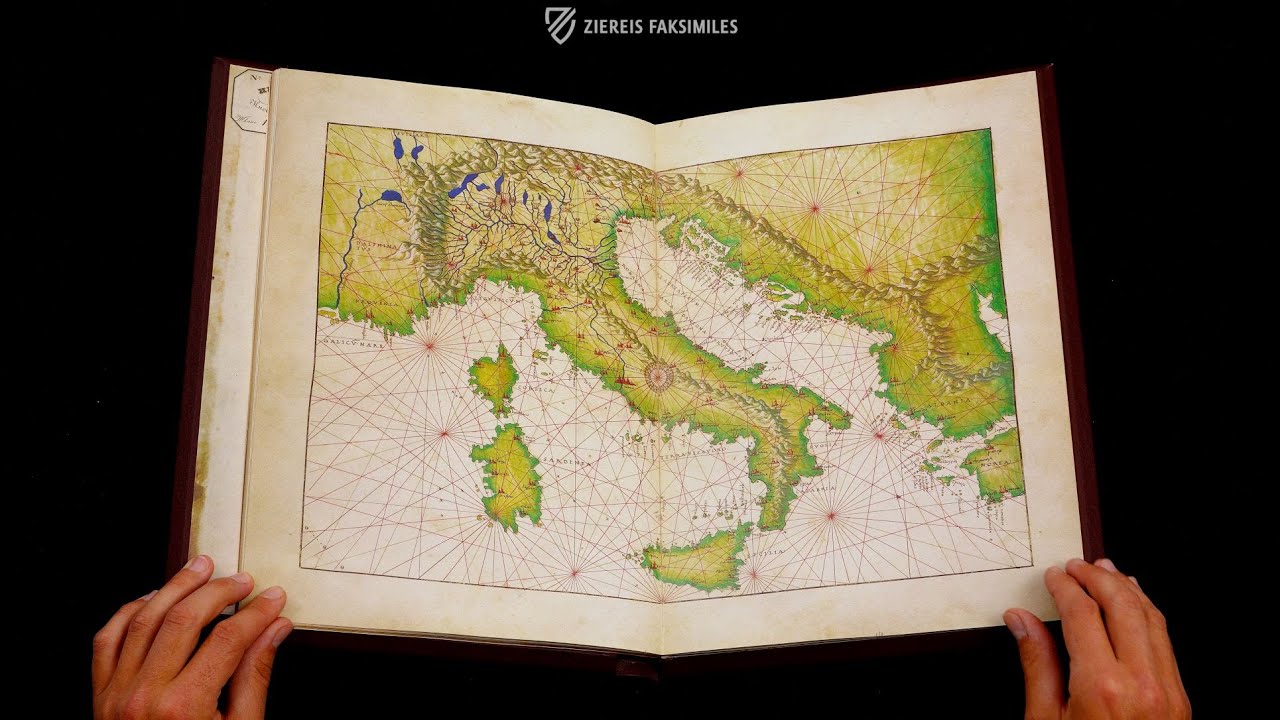
Lower Italy and Sicily
This map exemplifies the synthesis of artistry and science found in this cartographic masterpiece, which represents the latest state of geographic knowledge. In fact, this map of Italy is considered to be the finest of its time. An elaborate compass rose has been placed next to Rome on the western slopes of the Apennine Mountains, which are beautifully shaded and lead down to the toe of Calabria and the Strait of Messina separating Italy from Sicily.
 – National Library of Russia (St. Petersburg, Russia)")
Portolan Atlas of Battista Agnese - Codex Petersburg
World Map
This is the most significant map of this famous atlas. It represents the most current geographic knowledge of mid–16th century European cartographers with a surprising degree of accuracy and is rendered in an oval projection resembling a modern map. Rather than being a practical aid for navigators, this is a synthesis of the arts meant for display.
Brush strokes of gold leaf are judiciously applied across the double-page, ranging from marking significant cities to highlighting the hair of the figures blowing the world’s winds. However, the most interesting feature of this map is the simple black line that runs from southern Spain, across the globe, and back: it is the sea route chosen by Magellan for his circumnavigation of the globe.
 – National Library of Russia (St. Petersburg, Russia)")
#1 Der Portolan-Atlas des Battista Agnese
Language: German
The commentary volume is richly illustrated.
(1,000€ - 3,000€)
")
")
")
")
")
")
- Treatises / Secular Books
- Apocalypses / Beatus
- Astronomy / Astrology
- Bestiaries
- Bibles / Gospels
- Chronicles / History / Law
- Geography / Maps
- Saints' Lives
- Islam / Oriental
- Judaism / Hebrew
- Single Leaf Collections
- Leonardo da Vinci
- Literature / Poetry
- Liturgical Manuscripts
- Medicine / Botany / Alchemy
- Music
- Mythology / Prophecies
- Psalters
- Other Religious Books
- Games / Hunting
- Private Devotion Books
- Other Genres
- Afghanistan
- Armenia
- Austria
- Belgium
- Belize
- Bosnia and Herzegovina
- China
- Colombia
- Costa Rica
- Croatia
- Cyprus
- Czech Republic
- Denmark
- Egypt
- El Salvador
- Ethiopia
- France
- Germany
- Greece
- Guatemala
- Honduras
- Hungary
- India
- Iran
- Iraq
- Israel
- Italy
- Japan
- Jordan
- Kazakhstan
- Kyrgyzstan
- Lebanon
- Liechtenstein
- Luxembourg
- Mexico
- Morocco
- Netherlands
- Palestine
- Panama
- Peru
- Poland
- Portugal
- Romania
- Russia
- Serbia
- Spain
- Sri Lanka
- Sweden
- Switzerland
- Syria
- Tajikistan
- Turkey
- Turkmenistan
- Ukraine
- United Kingdom
- United States
- Uzbekistan
- Vatican City
- A. Oosthoek, van Holkema & Warendorf
- Aboca Museum
- Ajuntament de Valencia
- Akademie Verlag
- Akademische Druck- u. Verlagsanstalt (ADEVA)
- Aldo Ausilio Editore - Bottega d’Erasmo
- Alecto Historical Editions
- Alkuin Verlag
- Almqvist & Wiksell
- Amilcare Pizzi
- Andreas & Andreas Verlagsbuchhandlung
- Archa 90
- Archiv Verlag
- Archivi Edizioni
- Arnold Verlag
- ARS
- Ars Magna
- Ars Millenii
- Art Market
- ArtCodex
- AyN Ediciones
- Azimuth Editions
- Badenia Verlag
- Bärenreiter-Verlag
- Belser Verlag
- Belser Verlag / WK Wertkontor
- Benziger Verlag
- Bernardinum Wydawnictwo
- BiblioGemma
- Biblioteca Apostolica Vaticana (Vaticanstadt, Vaticanstadt)
- Bibliotheca Palatina Faksimile Verlag
- Bibliotheca Rara
- Boydell & Brewer
- Bramante Edizioni
- Bredius Genootschap
- Brepols Publishers
- British Library
- Brokarte
- C. Weckesser
- Caixa Catalunya
- Canesi
- CAPSA, Ars Scriptoria
- Caratzas Brothers, Publishers
- Carus Verlag
- Casamassima Libri
- Centrum Cartographie Verlag GmbH
- Chavane Verlag
- Christian Brandstätter Verlag
- Circulo Cientifico
- Club Bibliófilo Versol
- Club du Livre
- Club Internacional del Libro
- CM Editores
- Collegium Graphicum
- Collezione Apocrifa Da Vinci
- Comissão Nacional para as Comemorações dos Descobrimentos Portugueses
- Coron Verlag
- Corvina
- CTHS
- D. S. Brewer
- Damon
- De Agostini/UTET
- De Nederlandsche Boekhandel
- De Schutter
- Deuschle & Stemmle
- Deutscher Verlag für Kunstwissenschaft
- DIAMM
- Dropmore Press
- Droz
- E. Schreiber Graphische Kunstanstalten
- Ediciones Boreal
- Ediciones Grial
- Ediclube
- Edições Inapa
- Edilan
- Editalia
- Edition Deuschle
- Edition Georg Popp
- Edition Leipzig
- Edition Libri Illustri
- Editiones Reales Sitios S. L.
- Éditions de l'Oiseau Lyre
- Editions Medicina Rara
- Editorial Casariego
- Editorial Mintzoa
- Editrice Antenore
- Editrice Velar
- Edizioni Edison
- Egeria, S.L.
- Eikon Editores
- Electa
- Emery Walker Limited
- Enciclopèdia Catalana
- Eos-Verlag
- Ephesus Publishing
- Ernst Battenberg
- Eugrammia Press
- Extraordinary Editions
- Fackelverlag
- Facsimila Art & Edition
- Facsimile Editions Ltd.
- Facsimilia Art & Edition Ebert KG
- Faksimile Verlag
- Feuermann Verlag
- Folger Shakespeare Library
- Franco Cosimo Panini Editore
- Friedrich Wittig Verlag
- Fundación Hullera Vasco-Leonesa
- G. Braziller
- Gabriele Mazzotta Editore
- Gebr. Mann Verlag
- Gesellschaft für graphische Industrie
- Getty Research Institute
- Giovanni Domenico de Rossi
- Giunti Editore
- Goldenmark Librarium
- Graffiti
- Grafica European Center of Fine Arts
- Guido Pressler
- Guillermo Blazquez
- Gustav Kiepenheuer
- H. N. Abrams
- Harrassowitz
- Harvard University Press
- Helikon
- Hendrickson Publishers
- Henning Oppermann
- Herder Verlag
- Hes & De Graaf Publishers
- Hoepli
- Holbein-Verlag
- Houghton Library
- Hugo Schmidt Verlag
- Hungarian Academy of Sciences
- Idion Verlag
- Il Bulino, edizioni d'arte
- ILte
- Imago
- Insel Verlag
- Insel-Verlag Anton Kippenberger
- Instituto de Estudios Altoaragoneses
- Instituto Nacional de Antropología e Historia
- Introligatornia Budnik Jerzy
- Istituto dell'Enciclopedia Italiana - Treccani
- Istituto Ellenico di Studi Bizantini e Postbizantini
- Istituto Geografico De Agostini
- Istituto Poligrafico e Zecca dello Stato
- Italarte Art Establishments
- Jaca Book
- Jan Thorbecke Verlag
- Johnson Reprint Corporation
- Johnson Reprint Corporation
- Jos. Baer
- Josef Stocker
- Josef Stocker-Schmid
- Jugoslavija
- Karl W. Hiersemann
- Kasper Straube
- Kaydeda Ediciones
- Kindler Verlag / Coron Verlag
- Kodansha International Ltd.
- Konrad Kölbl Verlag
- Kurt Wolff Verlag
- La Liberia dello Stato
- La Linea Editrice
- La Meta Editore
- Lambert Schneider
- Landeskreditbank Baden-Württemberg
- Leo S. Olschki
- Les Incunables
- Liber Artis
- Library of Congress
- Libreria Musicale Italiana
- Lichtdruck
- Lito Immagine Editore
- Lumen Artis
- Lund Humphries
- M. Moleiro Editor
- Maison des Sciences de l'homme et de la société de Poitiers
- Manuscriptum
- Martinus Nijhoff
- Maruzen-Yushodo Co. Ltd.
- MASA
- Massada Publishers
- McGraw-Hill
- Metropolitan Museum of Art
- Militos
- Millennium Liber
- Müller & Schindler
- Nahar - Stavit
- Nahar and Steimatzky
- National Library of Wales
- Neri Pozza
- Nova Charta
- Oceanum Verlag
- Odeon
- Omnia Arte
- Orbis Mediaevalis
- Orbis Pictus
- Österreichische Staatsdruckerei
- Oxford University Press
- Pageant Books
- Parzellers Buchverlag
- Patrimonio Ediciones
- Pattloch Verlag
- PIAF
- Pieper Verlag
- Plon-Nourrit et cie
- Poligrafiche Bolis
- Presses Universitaires de Strasbourg
- Prestel Verlag
- Princeton University Press
- Prisma Verlag
- Priuli & Verlucca, editori
- Pro Sport Verlag
- Propyläen Verlag
- Pytheas Books
- Quaternio Verlag Luzern
- Reales Sitios
- Recht-Verlag
- Reichert Verlag
- Reichsdruckerei
- Reprint Verlag
- Riehn & Reusch
- Roberto Vattori Editore
- Rosenkilde and Bagger
- Roxburghe Club
- Salerno Editrice
- Saltellus Press
- Sandoz
- Sarajevo Svjetlost
- Schöck ArtPrint Kft.
- Schulsinger Brothers
- Scolar Press
- Scrinium
- Scripta Maneant
- Scriptorium
- Shazar
- Siloé, arte y bibliofilia
- SISMEL - Edizioni del Galluzzo
- Sociedad Mexicana de Antropología
- Société des Bibliophiles & Iconophiles de Belgique
- Soncin Publishing
- Sorli Ediciones
- Stainer and Bell
- Studer
- Styria Verlag
- Sumptibus Pragopress
- Szegedi Tudomànyegyetem
- Taberna Libraria
- Tarshish Books
- Taschen
- Tempus Libri
- Testimonio Compañía Editorial
- TGB Limited Editions
- Thames and Hudson
- The Clear Vue Publishing Partnership Limited
- The Facsimile Codex
- The Folio Society
- The Marquess of Normanby
- The Orphan Hospital Ward of Israel
- The Richard III and Yorkist History Trust
- The Warburg Institute
- Tip.Le.Co
- TouchArt
- TREC Publishing House
- TRI Publishing Co.
- Trident Editore
- Tuliba Collection
- Typis Regiae Officinae Polygraphicae
- Union Verlag Berlin
- Universidad de Granada
- Universitaire Bibliotheken Leiden
- University of California Press
- University of Chicago Press
- Urs Graf
- Vallecchi
- Van Wijnen
- VCH, Acta Humaniora
- VDI Verlag
- VEB Deutscher Verlag für Musik
- Verein Schweizerischer Lithographie-Besitzer
- Verlag Anton Pustet / Andreas Verlag
- Verlag Bibliophile Drucke Josef Stocker
- Verlag der Münchner Drucke
- Verlag für Regionalgeschichte
- Verlag Styria
- Vicent Garcia Editores
- W. Turnowsky
- Waanders Printers
- Wiener Mechitharisten-Congregation (Wien, Österreich)
- Wissenschaftliche Buchgesellschaft
- Wissenschaftliche Verlagsgesellschaft
- Wydawnictwo Dolnoslaskie
- Xuntanza Editorial
- Zakład Narodowy
- Zollikofer AG