Portolan Chart by Matteo Prunes
")
Mallorca (Spain) — Ca. 1563
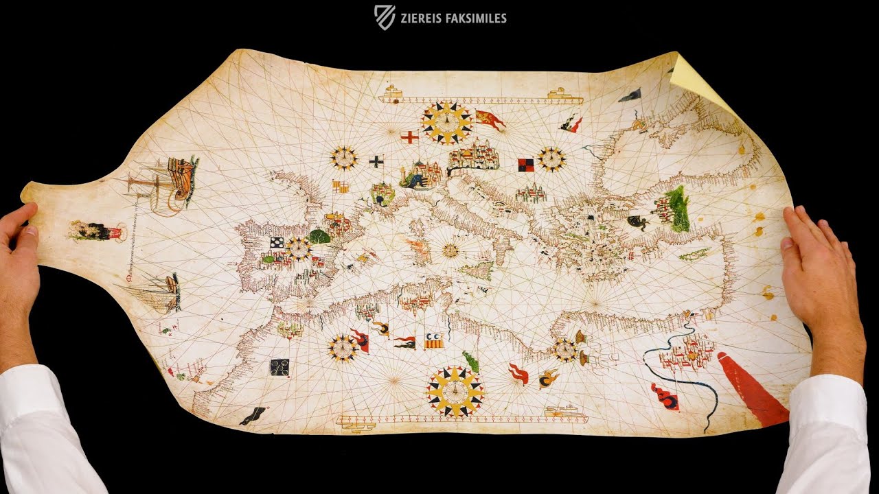
The contemporary state of the science of marine navigation: noble compass roses, mighty cities, and impressive sailing ships on the map made by a member of one of the oldest families of cartographers in Mallorca
Portolan charts are maps specifically designed and featuring information for navigation purposes
Mateo Prunes (1532-94) is credited with thirteen portolan charts and a four-sheet atlas
Compass roses, flags, coats of arms, and sailing ships adorn the artful and accurate map
Portolan Chart by Matteo Prunes

")
")
")
")
")
")
")
")
")
")
(1,000€ - 3,000€)
Mateo Prunes (1532–94) was a member of one of the longest-lived and best-known families of cartographers in Mallorca and was a splendid mapmaker in his own right. This portolan chart of the Mediterranean Sea and neighboring regions features artful ornamentation like compass roses, flags, coats of arms, and sailing ships, but is also extremely accurate and useful for navigation. The Portulano de Mateo Prunes is a fine specimen of 16th century cartography, when Mallorca lead the rest of Europe in this rapidly evolving science and families of cartographers like the Prunes passed down their skills and knowledge so that each generation could stand on the shoulders of the one that came before it.
Portolan Chart by Matteo Prunes
This manuscript on colored and gilded parchment was made by Mateo Prunes (1532–94), as an inscription on the parchment itself reads "Mateo Prunes in the city of Mallorca, 1563". It represents an abbreviated image of the Mediterranean world of the 16th century where the nearby enclaves are represented together with references to the New World via two ships sailing in a westerly direction. Its author was part of one of the longest-lived and best-known families of cartographers in Mallorca. Thirteen portolan charts and a four-sheet atlas are attributed to Prunes.
What is a Portolan Chart?
The medieval "portulanos", also called portolan charts, are cartographic instruments that, together with other nautical instruments such as the compass, became authentic tools that allowed navigators to move with certain security among the coasts of the Mediterranean. Its origin goes back to the so-called "periplos" that collected the oral tradition of the Greek and Roman navigators who took the courses following the coast. This experience continued to be transmitted, giving way to the "portolan charts", a geographical compilation that included peculiarities of the ports, approximate distances between coastal features, river mouths, news about anchorages, and any reference that could be useful for navigation. The transfer of all this written information to a parchment or similar surface resulted in what is known as a nautical chart or portolan chart. They began to be made during the Middle Ages in the 13th century and continued until the Early Modern era. They began to be made in a geographical area of the Mediterranean with an intense political, commercial, and cultural relationship concentrated in various cities, among which Mallorca, Genoa and Venice would stand out as major centers of cartographic production.
A Glimpse of the Mediterranean in the 16th Century
This detailed map measures 50 x 95 cm and shows the Mediterranean coasts of Europe, Africa, and the Near East as well as the Black Sea and eastern Atlantic Ocean, which features the Canary Islands, Madeira, and two ships sailing westward. A depiction of the Madonna and Child at the westernmost edge of the map accompanies the inscription identifying the Prunes. Compass roses, cities, flags, and coats of arms fill the map in the typical manner of the period but are executed by an expert hand. Aside from being artful, the map is extremely accurate and identifies thousands of ports, cities, and towns. This splendid artifact of 16th century cartography is stored today under the shelf mark PM-1 in Madrid’s Museo Naval, where it has been kept safe since 1926.
Codicology
- Alternative Titles
- Portulano del Mediterráneo de Mateo Prunes
Mittelmeer-Portolan von Mateo Prunes
Carta náutica de Mateo Prunes
Portolankarte des Mittelmeers von Mateo Prunes
Portulano de Mateo Prunes
Portolan Chart by Matteo Prunes - Type
- Map on parchment
- Size / Format
- 1 map / 52.0 × 96.0 cm
- Origin
- Spain
- Date
- Ca. 1563
- Epochs
- Style
- Genre
- Language
- Script
- Gothic
- Content
- Map of the Mediterranean area
- Artist / School
- Mateo Prunes
Mallorcan School of Cartography
")
Portolan Chart by Matteo Prunes
Inscription, Sailing Ships, Madonna and Child
Since maps were typically made from the hide of a sheep or some other animal, they often have a thin portion on one end corresponding to the neck. This provided a natural space for a depiction of the Madonna and Child, which was often included on maps originating from Mallorca during the Late Middle Ages. The inscription reading “Mateo Prunes in the city of Mallorca, 1563” is found between two ships: a large carrack bristling with canons and a small caravel with so-called lateen or triangular sails.
")
#1 Portulano del Mediterráneo de Mateo Prunes
Language: Spanish
(1,000€ - 3,000€)
")
")
")
")

")
- Treatises / Secular Books
- Apocalypses / Beatus
- Astronomy / Astrology
- Bestiaries
- Bibles / Gospels
- Chronicles / History / Law
- Geography / Maps
- Saints' Lives
- Islam / Oriental
- Judaism / Hebrew
- Single Leaf Collections
- Leonardo da Vinci
- Literature / Poetry
- Liturgical Manuscripts
- Medicine / Botany / Alchemy
- Music
- Mythology / Prophecies
- Psalters
- Other Religious Books
- Games / Hunting
- Private Devotion Books
- Other Genres
- Afghanistan
- Armenia
- Austria
- Belgium
- Belize
- Bosnia and Herzegovina
- China
- Colombia
- Costa Rica
- Croatia
- Cyprus
- Czech Republic
- Denmark
- Egypt
- El Salvador
- Ethiopia
- France
- Germany
- Greece
- Guatemala
- Honduras
- Hungary
- India
- Iran
- Iraq
- Israel
- Italy
- Japan
- Jordan
- Kazakhstan
- Kyrgyzstan
- Lebanon
- Liechtenstein
- Luxembourg
- Mexico
- Morocco
- Netherlands
- Palestine
- Panama
- Peru
- Poland
- Portugal
- Romania
- Russia
- Serbia
- Spain
- Sri Lanka
- Sweden
- Switzerland
- Syria
- Tajikistan
- Turkey
- Turkmenistan
- Ukraine
- United Kingdom
- United States
- Uzbekistan
- Vatican City
- A. Oosthoek, van Holkema & Warendorf
- Aboca Museum
- Ajuntament de Valencia
- Akademie Verlag
- Akademische Druck- u. Verlagsanstalt (ADEVA)
- Aldo Ausilio Editore - Bottega d’Erasmo
- Alecto Historical Editions
- Alkuin Verlag
- Almqvist & Wiksell
- Amilcare Pizzi
- Andreas & Andreas Verlagsbuchhandlung
- Archa 90
- Archiv Verlag
- Archivi Edizioni
- Arnold Verlag
- ARS
- Ars Magna
- Ars Millenii
- Art Market
- ArtCodex
- AyN Ediciones
- Azimuth Editions
- Badenia Verlag
- Bärenreiter-Verlag
- Belser Verlag
- Belser Verlag / WK Wertkontor
- Benziger Verlag
- Bernardinum Wydawnictwo
- BiblioGemma
- Biblioteca Apostolica Vaticana (Vaticanstadt, Vaticanstadt)
- Bibliotheca Palatina Faksimile Verlag
- Bibliotheca Rara
- Boydell & Brewer
- Bramante Edizioni
- Bredius Genootschap
- Brepols Publishers
- British Library
- Brokarte
- C. Weckesser
- Caixa Catalunya
- Canesi
- CAPSA, Ars Scriptoria
- Caratzas Brothers, Publishers
- Carus Verlag
- Casamassima Libri
- Centrum Cartographie Verlag GmbH
- Chavane Verlag
- Christian Brandstätter Verlag
- Circulo Cientifico
- Club Bibliófilo Versol
- Club du Livre
- Club Internacional del Libro
- CM Editores
- Collegium Graphicum
- Collezione Apocrifa Da Vinci
- Comissão Nacional para as Comemorações dos Descobrimentos Portugueses
- Coron Verlag
- Corvina
- CTHS
- D. S. Brewer
- Damon
- De Agostini/UTET
- De Nederlandsche Boekhandel
- De Schutter
- Deuschle & Stemmle
- Deutscher Verlag für Kunstwissenschaft
- DIAMM
- Dropmore Press
- Droz
- E. Schreiber Graphische Kunstanstalten
- Ediciones Boreal
- Ediciones Grial
- Ediclube
- Edições Inapa
- Edilan
- Editalia
- Edition Deuschle
- Edition Georg Popp
- Edition Leipzig
- Edition Libri Illustri
- Editiones Reales Sitios S. L.
- Éditions de l'Oiseau Lyre
- Editions Medicina Rara
- Editorial Casariego
- Editorial Mintzoa
- Editrice Antenore
- Editrice Velar
- Edizioni Edison
- Egeria, S.L.
- Eikon Editores
- Electa
- Emery Walker Limited
- Enciclopèdia Catalana
- Eos-Verlag
- Ephesus Publishing
- Ernst Battenberg
- Eugrammia Press
- Extraordinary Editions
- Fackelverlag
- Facsimila Art & Edition
- Facsimile Editions Ltd.
- Facsimilia Art & Edition Ebert KG
- Faksimile Verlag
- Feuermann Verlag
- Folger Shakespeare Library
- Franco Cosimo Panini Editore
- Friedrich Wittig Verlag
- Fundación Hullera Vasco-Leonesa
- G. Braziller
- Gabriele Mazzotta Editore
- Gebr. Mann Verlag
- Gesellschaft für graphische Industrie
- Getty Research Institute
- Giovanni Domenico de Rossi
- Giunti Editore
- Goldenmark Librarium
- Graffiti
- Grafica European Center of Fine Arts
- Guido Pressler
- Guillermo Blazquez
- Gustav Kiepenheuer
- H. N. Abrams
- Harrassowitz
- Harvard University Press
- Helikon
- Hendrickson Publishers
- Henning Oppermann
- Herder Verlag
- Hes & De Graaf Publishers
- Hoepli
- Holbein-Verlag
- Houghton Library
- Hugo Schmidt Verlag
- Hungarian Academy of Sciences
- Idion Verlag
- Il Bulino, edizioni d'arte
- ILte
- Imago
- Insel Verlag
- Insel-Verlag Anton Kippenberger
- Instituto de Estudios Altoaragoneses
- Instituto Nacional de Antropología e Historia
- Introligatornia Budnik Jerzy
- Istituto dell'Enciclopedia Italiana - Treccani
- Istituto Ellenico di Studi Bizantini e Postbizantini
- Istituto Geografico De Agostini
- Istituto Poligrafico e Zecca dello Stato
- Italarte Art Establishments
- Jaca Book
- Jan Thorbecke Verlag
- Johnson Reprint Corporation
- Johnson Reprint Corporation
- Jos. Baer
- Josef Stocker
- Josef Stocker-Schmid
- Jugoslavija
- Karl W. Hiersemann
- Kasper Straube
- Kaydeda Ediciones
- Kindler Verlag / Coron Verlag
- Kodansha International Ltd.
- Konrad Kölbl Verlag
- Kurt Wolff Verlag
- La Liberia dello Stato
- La Linea Editrice
- La Meta Editore
- Lambert Schneider
- Landeskreditbank Baden-Württemberg
- Leo S. Olschki
- Les Incunables
- Liber Artis
- Library of Congress
- Libreria Musicale Italiana
- Lichtdruck
- Lito Immagine Editore
- Lumen Artis
- Lund Humphries
- M. Moleiro Editor
- Maison des Sciences de l'homme et de la société de Poitiers
- Manuscriptum
- Martinus Nijhoff
- Maruzen-Yushodo Co. Ltd.
- MASA
- Massada Publishers
- McGraw-Hill
- Metropolitan Museum of Art
- Militos
- Millennium Liber
- Müller & Schindler
- Nahar - Stavit
- Nahar and Steimatzky
- National Library of Wales
- Neri Pozza
- Nova Charta
- Oceanum Verlag
- Odeon
- Omnia Arte
- Orbis Mediaevalis
- Orbis Pictus
- Österreichische Staatsdruckerei
- Oxford University Press
- Pageant Books
- Parzellers Buchverlag
- Patrimonio Ediciones
- Pattloch Verlag
- PIAF
- Pieper Verlag
- Plon-Nourrit et cie
- Poligrafiche Bolis
- Presses Universitaires de Strasbourg
- Prestel Verlag
- Princeton University Press
- Prisma Verlag
- Priuli & Verlucca, editori
- Pro Sport Verlag
- Propyläen Verlag
- Pytheas Books
- Quaternio Verlag Luzern
- Reales Sitios
- Recht-Verlag
- Reichert Verlag
- Reichsdruckerei
- Reprint Verlag
- Riehn & Reusch
- Roberto Vattori Editore
- Rosenkilde and Bagger
- Roxburghe Club
- Salerno Editrice
- Saltellus Press
- Sandoz
- Sarajevo Svjetlost
- Schöck ArtPrint Kft.
- Schulsinger Brothers
- Scolar Press
- Scrinium
- Scripta Maneant
- Scriptorium
- Shazar
- Siloé, arte y bibliofilia
- SISMEL - Edizioni del Galluzzo
- Sociedad Mexicana de Antropología
- Société des Bibliophiles & Iconophiles de Belgique
- Soncin Publishing
- Sorli Ediciones
- Stainer and Bell
- Studer
- Styria Verlag
- Sumptibus Pragopress
- Szegedi Tudomànyegyetem
- Taberna Libraria
- Tarshish Books
- Taschen
- Tempus Libri
- Testimonio Compañía Editorial
- TGB Limited Editions
- Thames and Hudson
- The Clear Vue Publishing Partnership Limited
- The Facsimile Codex
- The Folio Society
- The Marquess of Normanby
- The Orphan Hospital Ward of Israel
- The Richard III and Yorkist History Trust
- The Warburg Institute
- Tip.Le.Co
- TouchArt
- TREC Publishing House
- TRI Publishing Co.
- Trident Editore
- Tuliba Collection
- Typis Regiae Officinae Polygraphicae
- Union Verlag Berlin
- Universidad de Granada
- Universitaire Bibliotheken Leiden
- University of California Press
- University of Chicago Press
- Urs Graf
- Vallecchi
- Van Wijnen
- VCH, Acta Humaniora
- VDI Verlag
- VEB Deutscher Verlag für Musik
- Verein Schweizerischer Lithographie-Besitzer
- Verlag Anton Pustet / Andreas Verlag
- Verlag Bibliophile Drucke Josef Stocker
- Verlag der Münchner Drucke
- Verlag für Regionalgeschichte
- Verlag Styria
- Vicent Garcia Editores
- W. Turnowsky
- Waanders Printers
- Wiener Mechitharisten-Congregation (Wien, Österreich)
- Wissenschaftliche Buchgesellschaft
- Wissenschaftliche Verlagsgesellschaft
- Wydawnictwo Dolnoslaskie
- Xuntanza Editorial
- Zakład Narodowy
- Zollikofer AG