Map of Juan de la Cosa
")
Puerto de Santa María (Spain) — 1510
The world of Christopher Columbus and his travel companion: Juan de la Cosa's famous map showing all the regions of the Old and New Worlds known in Europe, as well as the first cartographic representation of the Americas
Juan de la Cosa (ca. 1450–1510) depicts the newly discovered regions of the Americas along with the Old World
De la Cosa accompanied Christopher Columbus (1451–1505) on three of his voyages as a captain and cartographer
Aside from his own findings, he also relied on those of Amerigo Vespucci, Pedro Cabral, and Vasco da Gama
Map of Juan de la Cosa
")
")
")
")
")
")
")
")
")
")
")
")
")
")
(under 1,000€)
Juan de la Cosa’s famous world map is a true wonder from the Age of Exploration ca. 1500. In it, de la Cosa unites all the newly discovered regions of the New World with known parts of the world. In this way they offer a comprehensive picture of the world at that time. De la Cosa accompanied Christopher Columbus on three of his voyages of discovery to the New World as a captain and cartographer, and thus was one of the first to be in the know concerning these new regions. Columbus himself left behind no maps, so the Map of Juan de la Cosa, which has inter alia the first depiction of America on it, represents a unique geographical attestation!
Map of Juan de la Cosa
Juan de la Cosa’s famous world map is a true wonder from the Age of Exploration ca. 1500. In it, de la Cosa unites all the newly discovered regions of the New World with known parts of the world. In this way they offer a comprehensive picture of the world at that time. De la Cosa accompanied Christopher Columbus on three of his voyages of discovery to the New World as a captain and cartographer, and thus was one of the first to be in the know concerning these new regions. Columbus himself left behind no maps, so the Map of Juan de la Cosa, which has inter alia the first depiction of America on it, represents a unique geographical attestation!
Columbus’ Captain
Juna de la Cosa (ca. 1449–1510) was an eyewitness and important figure of the Age of Discovery ca. 1500. As captain and owner of the Santa Maria, the ship with which Christopher Columbus departed in the year 1492 for his first voyage of discovery, he was among the first to study the exotic world of the Caribbean. Juan de la Cosa accompanied Columbus on his second and third voyages of discovery as a captain, valued advisor, and head cartographer. He possessed a comprehensive knowledge that made him a valuable travel companion. Altogether, de la Cosa undertook seven expeditions to the New World, among them with Amerigo Vespucci and Vasco Nunez de Balboa. He was killed in Columbia during one of these voyages of discovery in 1510 when he was hit by poisoned arrow during a battle with the Indios.
An Important Mappa Mundi
In the course of all these travels, particularly during the first expedition with Christopher Columbus, he collected the knowledge that would allow him to depict this New World. His famous world map probably originates in the year 1500 in Puerto de Santa Maria. The map, made of two ox hides joined together, has the dimensions of 183 x 96 cm. Here, de la Cosa presents all of the discoveries of his time. He did not just bring those lands under the Spanish flag into consideration, but all lands, and thus delivered a comprehensive picture of the world at that time.
The Oldest Known Map of America
Among others, the islands of the Caribbean, the Gulf of Mexico, and the then-known coasts of South America were depicted in detail. Cuba, then known as Juana, was correctly depicted for the first time as an island, whereas Columbus believed that it was only a peninsula of the great Indian subcontinent. Thereby Juan de la Cosa not only relied upon his own findings – it was impossible for him to travel the entire known world – but also on the most diverse sources, e.g. by records from Amerigo Vespucci, Pedro Cabral, and older information from Vasco da Gama.
A Lucky Find in the 19th Century
Today the world map by Juan de la Cosa is found in the Museo Naval in Madrid. It was lost and forgotten for a long time and was first rediscovered in the 19th century. In 1832, Charles Walckenauer, a French map researcher and subsequent director of the map collection of the French National Library, made a sensational discovery in a small Parisian antiquarian book shop. The news of this discovery reached Alexander von Humboldt, who concerned himself with the world map by Juan de la Cosa in his writings. Presumably, the map was removed from the Vatican archives and sent to France during the Napoleonic Wars. In 1853, after the death of Tod Walckenauers, the document of such historical significance was finally acquired by the Spanish government and in this way was returned to its originally intended destination.
Codicology
- Alternative Titles
- Mapa de Juan de la Cosa
Juan de la Cosa Map
Chart of Juan de la Cosa
Mapamundi de Juan de la Cosa
Karte von Juan de la Cosa - Type
- Map on parchment
- Size / Format
- 1 map / 183.0 × 96.0 cm
- Origin
- Spain
- Date
- 1510
- Epochs
- Style
- Genre
- Language
- Content
- World map including the recently discovered Americas
- Artist / School
- Juan de la Cosa (ca. 1450–1510)
- Previous Owners
- Juan Rodríguez de Fonseca (1451–1524)
Charles Athanase Walckenaer (1771–1852)
")
")
Map of Juan de la Cosa
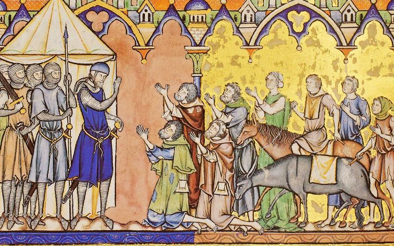
The Three Kings
Bearing their gifts for the King of the Jews, the Magi are shown on horseback following the star through Asia to the city Bethlehem. Although the part of the map concerning the Atlantic and the newly discovered Americas is based on the most recent cartographic discoveries, the depiction of Asia in this map still relies on myth, Ptolemaic models, and the travelogues of people like Marco Polo. As such, various biblical people and locations are also depicted on this historic map.
")
Map of Juan de la Cosa
First Glimpse of the New World
In contrast to a mappa mundi, which is east oriented, this map is focused on the newly discovered Americas and thus has west at the top of the map. In contrast to Europe and Africa, which are pale and covered with cities, the New World is a lush green landscape surrounding the Caribbean, wherein lies a few islands that the voyages of Columbus have actually mapped out with some precision.
While most maps show an image of the Madonna and Child at the top, there is an image of the patron saint of traveler and sailors, St. Christopher, under which Juan de la Cosa’s name appears. Instead, the Virgin Mary and the baby Jesus appear in the compass rose on a piece of paper that was pasted on the map, possibly drawn by Juan de la Cosa himself.
")
#1 Mapa de Juan de la Cosa
Language: Spanish
(under 1,000€)
#2 Carta Mapamundi de Juan de la Cosa
")
Language: Spanish
(under 1,000€)
")
")
")
")
")

- Treatises / Secular Books
- Apocalypses / Beatus
- Astronomy / Astrology
- Bestiaries
- Bibles / Gospels
- Chronicles / History / Law
- Geography / Maps
- Saints' Lives
- Islam / Oriental
- Judaism / Hebrew
- Single Leaf Collections
- Leonardo da Vinci
- Literature / Poetry
- Liturgical Manuscripts
- Medicine / Botany / Alchemy
- Music
- Mythology / Prophecies
- Psalters
- Other Religious Books
- Games / Hunting
- Private Devotion Books
- Other Genres
- Afghanistan
- Armenia
- Austria
- Belgium
- Belize
- Bosnia and Herzegovina
- China
- Colombia
- Costa Rica
- Croatia
- Cyprus
- Czech Republic
- Denmark
- Egypt
- El Salvador
- Ethiopia
- France
- Germany
- Greece
- Guatemala
- Honduras
- Hungary
- India
- Iran
- Iraq
- Israel
- Italy
- Japan
- Jordan
- Kazakhstan
- Kyrgyzstan
- Lebanon
- Liechtenstein
- Luxembourg
- Mexico
- Morocco
- Netherlands
- Palestine
- Panama
- Peru
- Poland
- Portugal
- Romania
- Russia
- Serbia
- Spain
- Sri Lanka
- Sweden
- Switzerland
- Syria
- Tajikistan
- Turkey
- Turkmenistan
- Ukraine
- United Kingdom
- United States
- Uzbekistan
- Vatican City
- A. Oosthoek, van Holkema & Warendorf
- Aboca Museum
- Ajuntament de Valencia
- Akademie Verlag
- Akademische Druck- u. Verlagsanstalt (ADEVA)
- Aldo Ausilio Editore - Bottega d’Erasmo
- Alecto Historical Editions
- Alkuin Verlag
- Almqvist & Wiksell
- Amilcare Pizzi
- Andreas & Andreas Verlagsbuchhandlung
- Archa 90
- Archiv Verlag
- Archivi Edizioni
- Arnold Verlag
- ARS
- Ars Magna
- Ars Millenii
- Art Market
- ArtCodex
- AyN Ediciones
- Azimuth Editions
- Badenia Verlag
- Bärenreiter-Verlag
- Belser Verlag
- Belser Verlag / WK Wertkontor
- Benziger Verlag
- Bernardinum Wydawnictwo
- BiblioGemma
- Biblioteca Apostolica Vaticana (Vaticanstadt, Vaticanstadt)
- Bibliotheca Palatina Faksimile Verlag
- Bibliotheca Rara
- Boydell & Brewer
- Bramante Edizioni
- Bredius Genootschap
- Brepols Publishers
- British Library
- Brokarte
- C. Weckesser
- Caixa Catalunya
- Canesi
- CAPSA, Ars Scriptoria
- Caratzas Brothers, Publishers
- Carus Verlag
- Casamassima Libri
- Centrum Cartographie Verlag GmbH
- Chavane Verlag
- Christian Brandstätter Verlag
- Circulo Cientifico
- Club Bibliófilo Versol
- Club du Livre
- Club Internacional del Libro
- CM Editores
- Collegium Graphicum
- Collezione Apocrifa Da Vinci
- Comissão Nacional para as Comemorações dos Descobrimentos Portugueses
- Coron Verlag
- Corvina
- CTHS
- D. S. Brewer
- Damon
- De Agostini/UTET
- De Nederlandsche Boekhandel
- De Schutter
- Deuschle & Stemmle
- Deutscher Verlag für Kunstwissenschaft
- DIAMM
- Dropmore Press
- Droz
- E. Schreiber Graphische Kunstanstalten
- Ediciones Boreal
- Ediciones Grial
- Ediclube
- Edições Inapa
- Edilan
- Editalia
- Edition Deuschle
- Edition Georg Popp
- Edition Leipzig
- Edition Libri Illustri
- Editiones Reales Sitios S. L.
- Éditions de l'Oiseau Lyre
- Editions Medicina Rara
- Editorial Casariego
- Editorial Mintzoa
- Editrice Antenore
- Editrice Velar
- Edizioni Edison
- Egeria, S.L.
- Eikon Editores
- Electa
- Emery Walker Limited
- Enciclopèdia Catalana
- Eos-Verlag
- Ephesus Publishing
- Ernst Battenberg
- Eugrammia Press
- Extraordinary Editions
- Fackelverlag
- Facsimila Art & Edition
- Facsimile Editions Ltd.
- Facsimilia Art & Edition Ebert KG
- Faksimile Verlag
- Feuermann Verlag
- Folger Shakespeare Library
- Franco Cosimo Panini Editore
- Friedrich Wittig Verlag
- Fundación Hullera Vasco-Leonesa
- G. Braziller
- Gabriele Mazzotta Editore
- Gebr. Mann Verlag
- Gesellschaft für graphische Industrie
- Getty Research Institute
- Giovanni Domenico de Rossi
- Giunti Editore
- Goldenmark Librarium
- Graffiti
- Grafica European Center of Fine Arts
- Guido Pressler
- Guillermo Blazquez
- Gustav Kiepenheuer
- H. N. Abrams
- Harrassowitz
- Harvard University Press
- Helikon
- Hendrickson Publishers
- Henning Oppermann
- Herder Verlag
- Hes & De Graaf Publishers
- Hoepli
- Holbein-Verlag
- Houghton Library
- Hugo Schmidt Verlag
- Hungarian Academy of Sciences
- Idion Verlag
- Il Bulino, edizioni d'arte
- ILte
- Imago
- Insel Verlag
- Insel-Verlag Anton Kippenberger
- Instituto de Estudios Altoaragoneses
- Instituto Nacional de Antropología e Historia
- Introligatornia Budnik Jerzy
- Istituto dell'Enciclopedia Italiana - Treccani
- Istituto Ellenico di Studi Bizantini e Postbizantini
- Istituto Geografico De Agostini
- Istituto Poligrafico e Zecca dello Stato
- Italarte Art Establishments
- Jaca Book
- Jan Thorbecke Verlag
- Johnson Reprint Corporation
- Johnson Reprint Corporation
- Jos. Baer
- Josef Stocker
- Josef Stocker-Schmid
- Jugoslavija
- Karl W. Hiersemann
- Kasper Straube
- Kaydeda Ediciones
- Kindler Verlag / Coron Verlag
- Kodansha International Ltd.
- Konrad Kölbl Verlag
- Kurt Wolff Verlag
- La Liberia dello Stato
- La Linea Editrice
- La Meta Editore
- Lambert Schneider
- Landeskreditbank Baden-Württemberg
- Leo S. Olschki
- Les Incunables
- Liber Artis
- Library of Congress
- Libreria Musicale Italiana
- Lichtdruck
- Lito Immagine Editore
- Lumen Artis
- Lund Humphries
- M. Moleiro Editor
- Maison des Sciences de l'homme et de la société de Poitiers
- Manuscriptum
- Martinus Nijhoff
- Maruzen-Yushodo Co. Ltd.
- MASA
- Massada Publishers
- McGraw-Hill
- Metropolitan Museum of Art
- Militos
- Millennium Liber
- Müller & Schindler
- Nahar - Stavit
- Nahar and Steimatzky
- National Library of Wales
- Neri Pozza
- Nova Charta
- Oceanum Verlag
- Odeon
- Omnia Arte
- Orbis Mediaevalis
- Orbis Pictus
- Österreichische Staatsdruckerei
- Oxford University Press
- Pageant Books
- Parzellers Buchverlag
- Patrimonio Ediciones
- Pattloch Verlag
- PIAF
- Pieper Verlag
- Plon-Nourrit et cie
- Poligrafiche Bolis
- Presses Universitaires de Strasbourg
- Prestel Verlag
- Princeton University Press
- Prisma Verlag
- Priuli & Verlucca, editori
- Pro Sport Verlag
- Propyläen Verlag
- Pytheas Books
- Quaternio Verlag Luzern
- Reales Sitios
- Recht-Verlag
- Reichert Verlag
- Reichsdruckerei
- Reprint Verlag
- Riehn & Reusch
- Roberto Vattori Editore
- Rosenkilde and Bagger
- Roxburghe Club
- Salerno Editrice
- Saltellus Press
- Sandoz
- Sarajevo Svjetlost
- Schöck ArtPrint Kft.
- Schulsinger Brothers
- Scolar Press
- Scrinium
- Scripta Maneant
- Scriptorium
- Shazar
- Siloé, arte y bibliofilia
- SISMEL - Edizioni del Galluzzo
- Sociedad Mexicana de Antropología
- Société des Bibliophiles & Iconophiles de Belgique
- Soncin Publishing
- Sorli Ediciones
- Stainer and Bell
- Studer
- Styria Verlag
- Sumptibus Pragopress
- Szegedi Tudomànyegyetem
- Taberna Libraria
- Tarshish Books
- Taschen
- Tempus Libri
- Testimonio Compañía Editorial
- TGB Limited Editions
- Thames and Hudson
- The Clear Vue Publishing Partnership Limited
- The Facsimile Codex
- The Folio Society
- The Marquess of Normanby
- The Orphan Hospital Ward of Israel
- The Richard III and Yorkist History Trust
- The Warburg Institute
- Tip.Le.Co
- TouchArt
- TREC Publishing House
- TRI Publishing Co.
- Trident Editore
- Tuliba Collection
- Typis Regiae Officinae Polygraphicae
- Union Verlag Berlin
- Universidad de Granada
- Universitaire Bibliotheken Leiden
- University of California Press
- University of Chicago Press
- Urs Graf
- Vallecchi
- Van Wijnen
- VCH, Acta Humaniora
- VDI Verlag
- VEB Deutscher Verlag für Musik
- Verein Schweizerischer Lithographie-Besitzer
- Verlag Anton Pustet / Andreas Verlag
- Verlag Bibliophile Drucke Josef Stocker
- Verlag der Münchner Drucke
- Verlag für Regionalgeschichte
- Verlag Styria
- Vicent Garcia Editores
- W. Turnowsky
- Waanders Printers
- Wiener Mechitharisten-Congregation (Wien, Österreich)
- Wissenschaftliche Buchgesellschaft
- Wissenschaftliche Verlagsgesellschaft
- Wydawnictwo Dolnoslaskie
- Xuntanza Editorial
- Zakład Narodowy
- Zollikofer AG