Khalili Portolan Atlas

Turkey — 17th century
A reorganization of cartographic material after the discovery of the New World by Columbus: 290 maps concerning different peoples and cultures from the point of view of the Ottoman Empire
Piri Reis (ca. 1465–1553) was an Ottoman admiral, navigator, geographer, and cartographer
His work synthesized Arab, Spanish, Portuguese, Chinese, Indian, and older Greek maps
It was updated in 1524–25 in order to be presented as a gift to Sultan Suleiman I (1494–1566)
Khalili Portolan Atlas


(1,000€ - 3,000€)
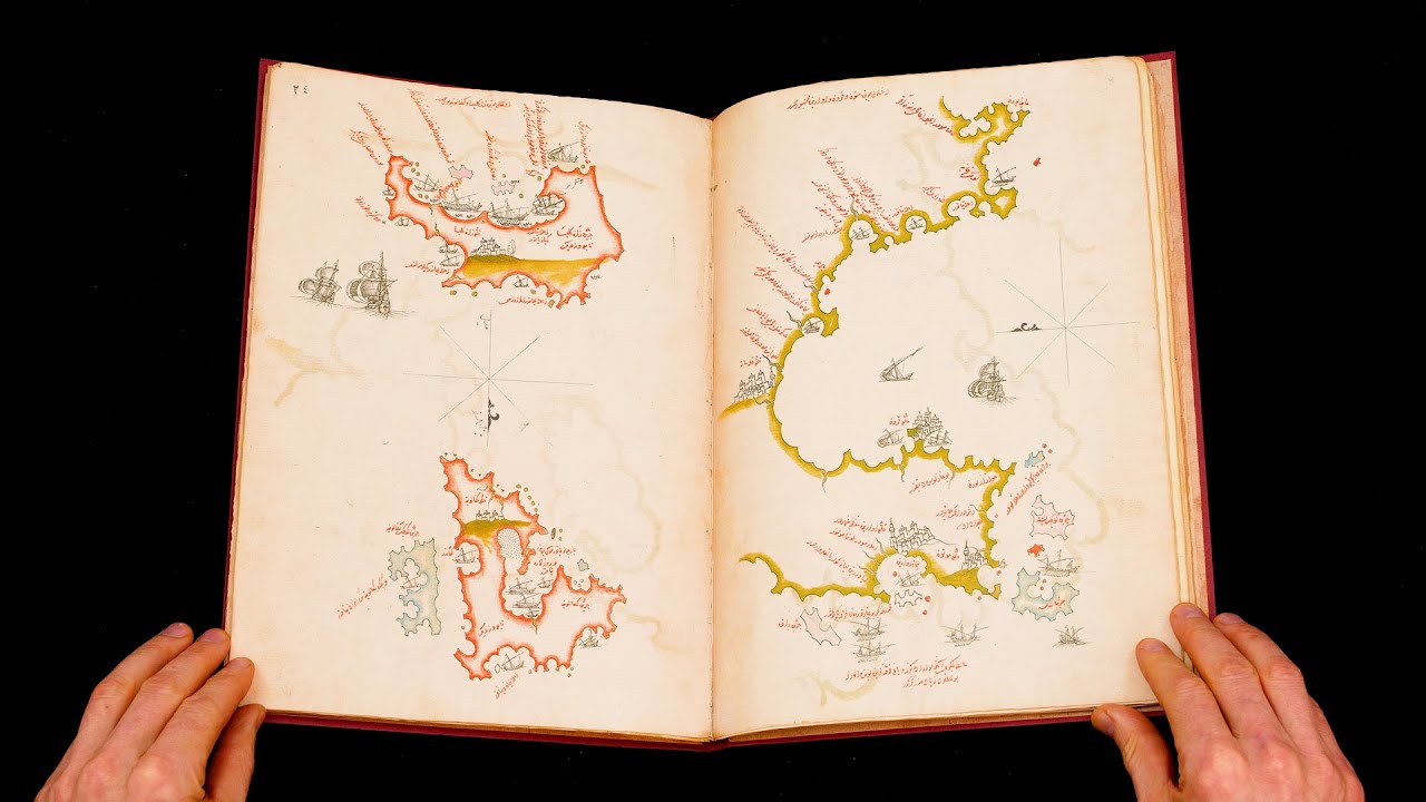
When Christopher Columbus inadvertently discovered the New World, it caused a sensation not only back in Europe but in the Muslim lands of the Near East. Piri Reis was an Ottoman admiral, navigator, geographer, and cartographer who created the Kitab-i bahriye or Book of Seamanship. Published in 1521, it is one of the most famous cartographical works of the period and contains 290 maps in addition to detailed geographical information as well as navigation techniques and information about the various peoples and cultures of the world. It was revised in 1524–25 with updated information and charts in order to be presented as a gift to Sultan Suleiman I. Although he was not an explorer and never saw the Atlantic Ocean, Piri Reis synthesized Arab, Spanish, Portuguese, Chinese, Indian, and older Greek maps into a comprehensive depiction of the world as it was known in the early 16th century.
Khalili Portolan Atlas
The Ottoman Empire was at its peak in the 16th century and Sultan Suleiman I (1494–1566) in Constantinople ruled over a territory stretching from the Balkans and the coasts of North Africa in the West to Persia in the East. This military success also brought a vast network of libraries, schools, and scholars under Ottoman control including almost the entirety of the Islamic scholarly tradition. Muslim scholars excelled in many fields, but none more so than astronomy, which is also an important tool for cartographers like Piri Reis (ca. 1465–1553). Armed with this knowledge, he created some of the most important cartographic works of the period, many of which survive today including several world maps and the Kitab-i bahriye or Book of Seamanship. The 17th century Khalili Portolan Atlas is largely based on this work but was updated with more recent Italian and Dutch geographic knowledge, includes the Black Sea unlike the original, and also incorporates a series of cityscapes including Istanbul, Venice, and Cairo that reveal the exuberance of Ottoman topographic painting.
Seafarers’ Handbook
The Kitab-i bahriye is one of the most famous cartographic works of the 16th century and is divided into two books. The first contains practical information for sailors on the coasts, islands, crossings, straits, and gulfs of the Mediterranean Sea and known regions of the Atlantic Ocean as well as instructions on how to use a compass, navigate with the stars, and approach individual ports. It also discusses various types of storms and gives advice on where to take refuge during a storm. The second section contains the portolan charts and cruise guides; it begins in the Dardanelles and follows the coastline and islands of the Mediterranean in a counterclockwise direction, first heading West until reaching the Strait of Gibraltar and Canary Islands then returning along the coast of North Africa and the Levant before ending with the Anatolian coastline.
A Blend of Ancient and Contemporary Knowledge
For source material, Piri was made use of more than twenty maps created by Arab, Spanish, Portuguese, Chinese, and Indian cartographers served as his source material. He also claims that some of the old Greek maps he used were drawn during the reign of Alexander the Great, but it is believed that he confused the 2nd century Greek geographer Ptolemy with the ancient Macedonian general and companion of Alexander’s who eventually ruled Egypt as Ptolemy I (ca. 367–282 BC). A Turkish translation of Ptolemy's Geographia had already been created at the behest of Mehmed II (1432–81) and would have been known to Piri.
Who Was Piri Reis?
Although little was known about Piri Reis for centuries, more recent research in the Ottoman archives has illuminated the biography of this important figure. First, Piri Reis was not his proper name but a name of convenience that actually translates to Captain Piri. His true name was Hacı Ahmed Muhiddin Piri and he was born either in Gallipoli on the banks of the Dardanelles or in Karaman, Central Anatolia, where his father Hacı Mehmed Piri was born. The title Hacı, which is Turkish for Hadji, indicates that both he and his father completed the Hajj by going to Mecca. In his youth, he served under his uncle Kemal Reis (ca. 1451 – 1511), a famous privateer who rose to the rank of admiral in the Ottoman Navy and saw as much action as an adventurous young man could ask for. He began his formal study of navigation and cartography in 1511 after his uncle died in a shipwreck before returning to active duty in 1516. In 1547, Piri was named Reis Pasha or admiral of the Ottoman fleets based in Egypt and the Indian Ocean. When he returned to Egypt at the age of 90 after a long and prestigious career, he was beheaded in 1533 for refusing to support another campaign against the Portuguese in the Persian Gulf. Several warships and submarines of the Turkish Navy have since been named after Piri Reis.
Codicology
- Type
- Map on paper
- Origin
- Turkey
- Date
- 17th century
- Epochs
- Style
- Genre

#1 The Khalili portolan atlas
Language: English
(1,000€ - 3,000€)
 – Biblioteca de la Universidad (Salamanca, Spain)")
")
")
")
")
")

- Treatises / Secular Books
- Apocalypses / Beatus
- Astronomy / Astrology
- Bestiaries
- Bibles / Gospels
- Chronicles / History / Law
- Geography / Maps
- Saints' Lives
- Islam / Oriental
- Judaism / Hebrew
- Single Leaf Collections
- Leonardo da Vinci
- Literature / Poetry
- Liturgical Manuscripts
- Medicine / Botany / Alchemy
- Music
- Mythology / Prophecies
- Psalters
- Other Religious Books
- Games / Hunting
- Private Devotion Books
- Other Genres
- Afghanistan
- Armenia
- Austria
- Belgium
- Belize
- Bosnia and Herzegovina
- China
- Colombia
- Costa Rica
- Croatia
- Cyprus
- Czech Republic
- Denmark
- Egypt
- El Salvador
- Ethiopia
- France
- Germany
- Greece
- Guatemala
- Honduras
- Hungary
- India
- Iran
- Iraq
- Israel
- Italy
- Japan
- Jordan
- Kazakhstan
- Kyrgyzstan
- Lebanon
- Liechtenstein
- Luxembourg
- Mexico
- Morocco
- Netherlands
- Palestine
- Panama
- Peru
- Poland
- Portugal
- Romania
- Russia
- Serbia
- Spain
- Sri Lanka
- Sweden
- Switzerland
- Syria
- Tajikistan
- Turkey
- Turkmenistan
- Ukraine
- United Kingdom
- United States
- Uzbekistan
- Vatican City
- A. Oosthoek, van Holkema & Warendorf
- Aboca Museum
- Ajuntament de Valencia
- Akademie Verlag
- Akademische Druck- u. Verlagsanstalt (ADEVA)
- Aldo Ausilio Editore - Bottega d’Erasmo
- Alecto Historical Editions
- Alkuin Verlag
- Almqvist & Wiksell
- Amilcare Pizzi
- Andreas & Andreas Verlagsbuchhandlung
- Archa 90
- Archiv Verlag
- Archivi Edizioni
- Arnold Verlag
- ARS
- Ars Magna
- Ars Millenii
- Art Market
- ArtCodex
- AyN Ediciones
- Azimuth Editions
- Badenia Verlag
- Bärenreiter-Verlag
- Belser Verlag
- Belser Verlag / WK Wertkontor
- Benziger Verlag
- Bernardinum Wydawnictwo
- BiblioGemma
- Biblioteca Apostolica Vaticana (Vaticanstadt, Vaticanstadt)
- Bibliotheca Palatina Faksimile Verlag
- Bibliotheca Rara
- Boydell & Brewer
- Bramante Edizioni
- Bredius Genootschap
- Brepols Publishers
- British Library
- Brokarte
- C. Weckesser
- Caixa Catalunya
- Canesi
- CAPSA, Ars Scriptoria
- Caratzas Brothers, Publishers
- Carus Verlag
- Casamassima Libri
- Centrum Cartographie Verlag GmbH
- Chavane Verlag
- Christian Brandstätter Verlag
- Circulo Cientifico
- Club Bibliófilo Versol
- Club du Livre
- Club Internacional del Libro
- CM Editores
- Collegium Graphicum
- Collezione Apocrifa Da Vinci
- Comissão Nacional para as Comemorações dos Descobrimentos Portugueses
- Coron Verlag
- Corvina
- CTHS
- D. S. Brewer
- Damon
- De Agostini/UTET
- De Nederlandsche Boekhandel
- De Schutter
- Deuschle & Stemmle
- Deutscher Verlag für Kunstwissenschaft
- DIAMM
- Dropmore Press
- Droz
- E. Schreiber Graphische Kunstanstalten
- Ediciones Boreal
- Ediciones Grial
- Ediclube
- Edições Inapa
- Edilan
- Editalia
- Edition Deuschle
- Edition Georg Popp
- Edition Leipzig
- Edition Libri Illustri
- Editiones Reales Sitios S. L.
- Éditions de l'Oiseau Lyre
- Editions Medicina Rara
- Editorial Casariego
- Editorial Mintzoa
- Editrice Antenore
- Editrice Velar
- Edizioni Edison
- Egeria, S.L.
- Eikon Editores
- Electa
- Emery Walker Limited
- Enciclopèdia Catalana
- Eos-Verlag
- Ephesus Publishing
- Ernst Battenberg
- Eugrammia Press
- Extraordinary Editions
- Fackelverlag
- Facsimila Art & Edition
- Facsimile Editions Ltd.
- Facsimilia Art & Edition Ebert KG
- Faksimile Verlag
- Feuermann Verlag
- Folger Shakespeare Library
- Franco Cosimo Panini Editore
- Friedrich Wittig Verlag
- Fundación Hullera Vasco-Leonesa
- G. Braziller
- Gabriele Mazzotta Editore
- Gebr. Mann Verlag
- Gesellschaft für graphische Industrie
- Getty Research Institute
- Giovanni Domenico de Rossi
- Giunti Editore
- Goldenmark Librarium
- Graffiti
- Grafica European Center of Fine Arts
- Guido Pressler
- Guillermo Blazquez
- Gustav Kiepenheuer
- H. N. Abrams
- Harrassowitz
- Harvard University Press
- Helikon
- Hendrickson Publishers
- Henning Oppermann
- Herder Verlag
- Hes & De Graaf Publishers
- Hoepli
- Holbein-Verlag
- Houghton Library
- Hugo Schmidt Verlag
- Hungarian Academy of Sciences
- Idion Verlag
- Il Bulino, edizioni d'arte
- ILte
- Imago
- Insel Verlag
- Insel-Verlag Anton Kippenberger
- Instituto de Estudios Altoaragoneses
- Instituto Nacional de Antropología e Historia
- Introligatornia Budnik Jerzy
- Istituto dell'Enciclopedia Italiana - Treccani
- Istituto Ellenico di Studi Bizantini e Postbizantini
- Istituto Geografico De Agostini
- Istituto Poligrafico e Zecca dello Stato
- Italarte Art Establishments
- Jaca Book
- Jan Thorbecke Verlag
- Johnson Reprint Corporation
- Johnson Reprint Corporation
- Jos. Baer
- Josef Stocker
- Josef Stocker-Schmid
- Jugoslavija
- Karl W. Hiersemann
- Kasper Straube
- Kaydeda Ediciones
- Kindler Verlag / Coron Verlag
- Kodansha International Ltd.
- Konrad Kölbl Verlag
- Kurt Wolff Verlag
- La Liberia dello Stato
- La Linea Editrice
- La Meta Editore
- Lambert Schneider
- Landeskreditbank Baden-Württemberg
- Leo S. Olschki
- Les Incunables
- Liber Artis
- Library of Congress
- Libreria Musicale Italiana
- Lichtdruck
- Lito Immagine Editore
- Lumen Artis
- Lund Humphries
- M. Moleiro Editor
- Maison des Sciences de l'homme et de la société de Poitiers
- Manuscriptum
- Martinus Nijhoff
- Maruzen-Yushodo Co. Ltd.
- MASA
- Massada Publishers
- McGraw-Hill
- Metropolitan Museum of Art
- Militos
- Millennium Liber
- Müller & Schindler
- Nahar - Stavit
- Nahar and Steimatzky
- National Library of Wales
- Neri Pozza
- Nova Charta
- Oceanum Verlag
- Odeon
- Omnia Arte
- Orbis Mediaevalis
- Orbis Pictus
- Österreichische Staatsdruckerei
- Oxford University Press
- Pageant Books
- Parzellers Buchverlag
- Patrimonio Ediciones
- Pattloch Verlag
- PIAF
- Pieper Verlag
- Plon-Nourrit et cie
- Poligrafiche Bolis
- Presses Universitaires de Strasbourg
- Prestel Verlag
- Princeton University Press
- Prisma Verlag
- Priuli & Verlucca, editori
- Pro Sport Verlag
- Propyläen Verlag
- Pytheas Books
- Quaternio Verlag Luzern
- Reales Sitios
- Recht-Verlag
- Reichert Verlag
- Reichsdruckerei
- Reprint Verlag
- Riehn & Reusch
- Roberto Vattori Editore
- Rosenkilde and Bagger
- Roxburghe Club
- Salerno Editrice
- Saltellus Press
- Sandoz
- Sarajevo Svjetlost
- Schöck ArtPrint Kft.
- Schulsinger Brothers
- Scolar Press
- Scrinium
- Scripta Maneant
- Scriptorium
- Shazar
- Siloé, arte y bibliofilia
- SISMEL - Edizioni del Galluzzo
- Sociedad Mexicana de Antropología
- Société des Bibliophiles & Iconophiles de Belgique
- Soncin Publishing
- Sorli Ediciones
- Stainer and Bell
- Studer
- Styria Verlag
- Sumptibus Pragopress
- Szegedi Tudomànyegyetem
- Taberna Libraria
- Tarshish Books
- Taschen
- Tempus Libri
- Testimonio Compañía Editorial
- TGB Limited Editions
- Thames and Hudson
- The Clear Vue Publishing Partnership Limited
- The Facsimile Codex
- The Folio Society
- The Marquess of Normanby
- The Orphan Hospital Ward of Israel
- The Richard III and Yorkist History Trust
- The Warburg Institute
- Tip.Le.Co
- TouchArt
- TREC Publishing House
- TRI Publishing Co.
- Trident Editore
- Tuliba Collection
- Typis Regiae Officinae Polygraphicae
- Union Verlag Berlin
- Universidad de Granada
- Universitaire Bibliotheken Leiden
- University of California Press
- University of Chicago Press
- Urs Graf
- Vallecchi
- Van Wijnen
- VCH, Acta Humaniora
- VDI Verlag
- VEB Deutscher Verlag für Musik
- Verein Schweizerischer Lithographie-Besitzer
- Verlag Anton Pustet / Andreas Verlag
- Verlag Bibliophile Drucke Josef Stocker
- Verlag der Münchner Drucke
- Verlag für Regionalgeschichte
- Verlag Styria
- Vicent Garcia Editores
- W. Turnowsky
- Waanders Printers
- Wiener Mechitharisten-Congregation (Wien, Österreich)
- Wissenschaftliche Buchgesellschaft
- Wissenschaftliche Verlagsgesellschaft
- Wydawnictwo Dolnoslaskie
- Xuntanza Editorial
- Zakład Narodowy
- Zollikofer AG