Portulan C.G.A.5.d
")
Mallorca (Spain) — Ca. 1450
The whole world at the time of the Renaissance in one map: the geographical knowledge of the 15th century in a magnificently illuminated sea chart from the famous cartographic school of Mallorca
This nautical map originated in Mallorca, home of the most important cartography school in Europe
The map shows the entire Mediterranean region, the British Isles, Central Europe, and Africa
It displays the entire world as it was known to the geographers and cartographers of the Renaissance
Portulan C.G.A.5.d

")
")
")
")
")
")
")
")
")
")
")
")
")
")
")
(under 1,000€)
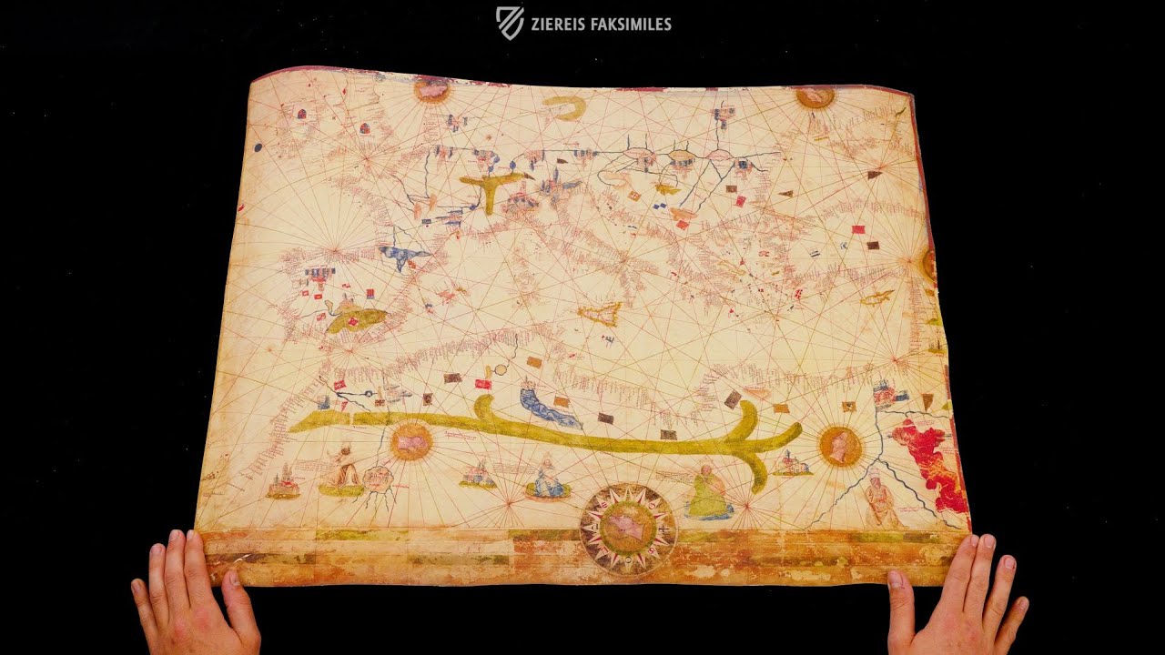
The Portulan C.G.A.5.d was created around 1450 in the famous Majorcan school of cartography. The map is a fascinating testimony to the awakening Renaissance and is among the most important geographical material of the Middle Ages still preserved today. It shows the entire Mediterranean region, the British Isles, part of Central Europe and the west coast of Africa as far as Cape Bojador. The areas of the then known world were impressively depicted here in great detail and with artistic care. Significant landmarks such as mountains and important trading cities were particularly emphasised. Despite its rather rich pictorial decoration, the precious map was very likely used by seafarers for navigation, which makes it a particularly fascinating testimony to the achievements of the Majorcan school of cartography, now kept in the Biblioteca Estense in Modena.
Portulan C.G.A.5.d
In the 15th century, Spain and Portugal were the lands under whose flags the most expeditions into largely unexplored regions of the world were made. In the course of many expeditions and discoveries, the most renowned school of geography and cartography in Europe took shape in Spain. The maps, which originated during the time of the awakening Renaissance, belong among the most important geographical material of the entire Middle Ages. It is truly astounding, how true to detail and correct the Spanish and Portuguese cartographers could represent the regions of the world they studied, and completely without the modern technical aids of our time. Portulan C.G.A.5.d is an outstanding example of the excellent work of medieval scholars.
What is a Portulan?
The term portulan or portolan originally indicated a book with nautical information such as landmarks, lighthouses, currents, and harbor conditions. According to historical sources, such sea-books already existed in the 13th century. Beginning in the 16th century, the term broadened and from then on comprised not only the written descriptions, but also the accompanying nautical maps, which were contained in books. Today, the term “portulan chart” indicate a very precise type of map. The map Portulan C.G.A.5.d is one of these special maps.
The Medieval World of Navigation
Portulan C.G.A.5.d displays the entire medieval world as it was known to the geographers and cartographers of the Renaissance. The shores of the Atlantic from the British Isles to Cape Bojador in Africa are depicted along with part of Central Europe down to the territories of North Africa. The Alps in particular were decoratively rendered. Similarly, the Pyrenees Mountains and the most important cities of Europe such as Venice, Genoa, Prague, Granada, Santiago de Compostela, and the Balearic Islands are meticulously depicted. The depiction of the African continent is particularly interesting. There the Atlas Mountains tower in luminous colors and an inscription near the Red Sea reminds one of the Flight of the Hebrews from Egypt during which Moses parted that sea.
Codicology
- Alternative Titles
- Portolano CGA5d
Portolan map C.G.A.5.d
Portolan-Karte C.G.A.5.d - Type
- Map on parchment
- Size / Format
- 1 map / 59.0 × 76.0 cm
- Origin
- Spain
- Date
- Ca. 1450
- Epochs
- Style
- Genre
- Language
- Script
- Humanistic
- Illustrations
- The map is decorated with enthroned figures, detailed views of cities, medallions of the four winds and various colored flags, coats of arms, and landmarks
- Content
- Map of the Mediterranean including parts of North Africa, Europe, and the British Isles
- Artist / School
- Mallorcan school of cartography
")
")
")
Portulan C.G.A.5.d
Atlas Mountains
The Atlas Mountains stretch around 2,300 kilometres through the northwest of the African continent across the modern-day states of Morocco, Algeria and Tunisia. At 4167 metres, the Toubkal is the highest peak of the huge mountain range, which is made up of several mountain chains. The Portulan map shows it as a broad green strip stretching from the Atlantic coast in the west to the area of present-day Libya, where three other mountains are located: the Haruj, the Jebel Akhdar and foothills of the Tibesti Mountains. On the map, they correspond to the three eastern branches of the green strip that connects the Atlas with the Libyan mountains.
")
Portulan C.G.A.5.d
Nautical Chart of the Mediterranean and North Africa
Created in Mallorca ca. 1450–60, this colorful map depicts the Mediterranean and Black Seas as well as the rivers that served as highways to the interiors of Western and Central Europe and North Africa. Both the Alps and the Pyrenees Mountains are drawn in a typical T-shape (the former green and the latter blue). The Atlantic coast ranges from the British Isles to Cape Bojador on the Moroccan coast. Other European locations highlighted by the map include Venice, Genoa, Prague, Granada, Santiago de Compostela, and the Balearic Islands.
The cities of Central Europe are labelled and drawn upside down so as to be more easily read from the upper margin, clearly designed to be laid in the center of a room and examined from all sides. Much detail is given to North Africa with depictions of the Atlas Mountains, various seated figures, and a caption next to the Red Sea describing the flight of the Israelites from Egypt. Human heads depicted in profile occupy the center of the 59 × 76 cm map’s various compass roses.
")
#1 Portolani (set of 3 maps in deluxe wooden case, includes C.G.A.5.d)
Language: Italian
(under 1,000€)
#2 Portolano C.G.A.5.d (map in tube)
")
Language: Italian
(1,000€ - 3,000€)
#3 Portolani (set of 3 maps in case, includes C.G.A.5.d)
")
Language: Italian
(1,000€ - 3,000€)
")
")
")
")
- Treatises / Secular Books
- Apocalypses / Beatus
- Astronomy / Astrology
- Bestiaries
- Bibles / Gospels
- Chronicles / History / Law
- Geography / Maps
- Saints' Lives
- Islam / Oriental
- Judaism / Hebrew
- Single Leaf Collections
- Leonardo da Vinci
- Literature / Poetry
- Liturgical Manuscripts
- Medicine / Botany / Alchemy
- Music
- Mythology / Prophecies
- Psalters
- Other Religious Books
- Games / Hunting
- Private Devotion Books
- Other Genres
- Afghanistan
- Armenia
- Austria
- Belgium
- Belize
- Bosnia and Herzegovina
- China
- Colombia
- Costa Rica
- Croatia
- Cyprus
- Czech Republic
- Denmark
- Egypt
- El Salvador
- Ethiopia
- France
- Germany
- Greece
- Guatemala
- Honduras
- Hungary
- India
- Iran
- Iraq
- Israel
- Italy
- Japan
- Jordan
- Kazakhstan
- Kyrgyzstan
- Lebanon
- Liechtenstein
- Luxembourg
- Mexico
- Morocco
- Netherlands
- Palestine
- Panama
- Peru
- Poland
- Portugal
- Romania
- Russia
- Serbia
- Spain
- Sri Lanka
- Sweden
- Switzerland
- Syria
- Tajikistan
- Turkey
- Turkmenistan
- Ukraine
- United Kingdom
- United States
- Uzbekistan
- Vatican City
- A. Oosthoek, van Holkema & Warendorf
- Aboca Museum
- Ajuntament de Valencia
- Akademie Verlag
- Akademische Druck- u. Verlagsanstalt (ADEVA)
- Aldo Ausilio Editore - Bottega d’Erasmo
- Alecto Historical Editions
- Alkuin Verlag
- Almqvist & Wiksell
- Amilcare Pizzi
- Andreas & Andreas Verlagsbuchhandlung
- Archa 90
- Archiv Verlag
- Archivi Edizioni
- Arnold Verlag
- ARS
- Ars Magna
- Ars Millenii
- Art Market
- ArtCodex
- AyN Ediciones
- Azimuth Editions
- Badenia Verlag
- Bärenreiter-Verlag
- Belser Verlag
- Belser Verlag / WK Wertkontor
- Benziger Verlag
- Bernardinum Wydawnictwo
- BiblioGemma
- Biblioteca Apostolica Vaticana (Vaticanstadt, Vaticanstadt)
- Bibliotheca Palatina Faksimile Verlag
- Bibliotheca Rara
- Boydell & Brewer
- Bramante Edizioni
- Bredius Genootschap
- Brepols Publishers
- British Library
- Brokarte
- C. Weckesser
- Caixa Catalunya
- Canesi
- CAPSA, Ars Scriptoria
- Caratzas Brothers, Publishers
- Carus Verlag
- Casamassima Libri
- Centrum Cartographie Verlag GmbH
- Chavane Verlag
- Christian Brandstätter Verlag
- Circulo Cientifico
- Club Bibliófilo Versol
- Club du Livre
- Club Internacional del Libro
- CM Editores
- Collegium Graphicum
- Collezione Apocrifa Da Vinci
- Comissão Nacional para as Comemorações dos Descobrimentos Portugueses
- Coron Verlag
- Corvina
- CTHS
- D. S. Brewer
- Damon
- De Agostini/UTET
- De Nederlandsche Boekhandel
- De Schutter
- Deuschle & Stemmle
- Deutscher Verlag für Kunstwissenschaft
- DIAMM
- Dropmore Press
- Droz
- E. Schreiber Graphische Kunstanstalten
- Ediciones Boreal
- Ediciones Grial
- Ediclube
- Edições Inapa
- Edilan
- Editalia
- Edition Deuschle
- Edition Georg Popp
- Edition Leipzig
- Edition Libri Illustri
- Editiones Reales Sitios S. L.
- Éditions de l'Oiseau Lyre
- Editions Medicina Rara
- Editorial Casariego
- Editorial Mintzoa
- Editrice Antenore
- Editrice Velar
- Edizioni Edison
- Egeria, S.L.
- Eikon Editores
- Electa
- Emery Walker Limited
- Enciclopèdia Catalana
- Eos-Verlag
- Ephesus Publishing
- Ernst Battenberg
- Eugrammia Press
- Extraordinary Editions
- Fackelverlag
- Facsimila Art & Edition
- Facsimile Editions Ltd.
- Facsimilia Art & Edition Ebert KG
- Faksimile Verlag
- Feuermann Verlag
- Folger Shakespeare Library
- Franco Cosimo Panini Editore
- Friedrich Wittig Verlag
- Fundación Hullera Vasco-Leonesa
- G. Braziller
- Gabriele Mazzotta Editore
- Gebr. Mann Verlag
- Gesellschaft für graphische Industrie
- Getty Research Institute
- Giovanni Domenico de Rossi
- Giunti Editore
- Goldenmark Librarium
- Graffiti
- Grafica European Center of Fine Arts
- Guido Pressler
- Guillermo Blazquez
- Gustav Kiepenheuer
- H. N. Abrams
- Harrassowitz
- Harvard University Press
- Helikon
- Hendrickson Publishers
- Henning Oppermann
- Herder Verlag
- Hes & De Graaf Publishers
- Hoepli
- Holbein-Verlag
- Houghton Library
- Hugo Schmidt Verlag
- Hungarian Academy of Sciences
- Idion Verlag
- Il Bulino, edizioni d'arte
- ILte
- Imago
- Insel Verlag
- Insel-Verlag Anton Kippenberger
- Instituto de Estudios Altoaragoneses
- Instituto Nacional de Antropología e Historia
- Introligatornia Budnik Jerzy
- Istituto dell'Enciclopedia Italiana - Treccani
- Istituto Ellenico di Studi Bizantini e Postbizantini
- Istituto Geografico De Agostini
- Istituto Poligrafico e Zecca dello Stato
- Italarte Art Establishments
- Jaca Book
- Jan Thorbecke Verlag
- Johnson Reprint Corporation
- Johnson Reprint Corporation
- Jos. Baer
- Josef Stocker
- Josef Stocker-Schmid
- Jugoslavija
- Karl W. Hiersemann
- Kasper Straube
- Kaydeda Ediciones
- Kindler Verlag / Coron Verlag
- Kodansha International Ltd.
- Konrad Kölbl Verlag
- Kurt Wolff Verlag
- La Liberia dello Stato
- La Linea Editrice
- La Meta Editore
- Lambert Schneider
- Landeskreditbank Baden-Württemberg
- Leo S. Olschki
- Les Incunables
- Liber Artis
- Library of Congress
- Libreria Musicale Italiana
- Lichtdruck
- Lito Immagine Editore
- Lumen Artis
- Lund Humphries
- M. Moleiro Editor
- Maison des Sciences de l'homme et de la société de Poitiers
- Manuscriptum
- Martinus Nijhoff
- Maruzen-Yushodo Co. Ltd.
- MASA
- Massada Publishers
- McGraw-Hill
- Metropolitan Museum of Art
- Militos
- Millennium Liber
- Müller & Schindler
- Nahar - Stavit
- Nahar and Steimatzky
- National Library of Wales
- Neri Pozza
- Nova Charta
- Oceanum Verlag
- Odeon
- Omnia Arte
- Orbis Mediaevalis
- Orbis Pictus
- Österreichische Staatsdruckerei
- Oxford University Press
- Pageant Books
- Parzellers Buchverlag
- Patrimonio Ediciones
- Pattloch Verlag
- PIAF
- Pieper Verlag
- Plon-Nourrit et cie
- Poligrafiche Bolis
- Presses Universitaires de Strasbourg
- Prestel Verlag
- Princeton University Press
- Prisma Verlag
- Priuli & Verlucca, editori
- Pro Sport Verlag
- Propyläen Verlag
- Pytheas Books
- Quaternio Verlag Luzern
- Reales Sitios
- Recht-Verlag
- Reichert Verlag
- Reichsdruckerei
- Reprint Verlag
- Riehn & Reusch
- Roberto Vattori Editore
- Rosenkilde and Bagger
- Roxburghe Club
- Salerno Editrice
- Saltellus Press
- Sandoz
- Sarajevo Svjetlost
- Schöck ArtPrint Kft.
- Schulsinger Brothers
- Scolar Press
- Scrinium
- Scripta Maneant
- Scriptorium
- Shazar
- Siloé, arte y bibliofilia
- SISMEL - Edizioni del Galluzzo
- Sociedad Mexicana de Antropología
- Société des Bibliophiles & Iconophiles de Belgique
- Soncin Publishing
- Sorli Ediciones
- Stainer and Bell
- Studer
- Styria Verlag
- Sumptibus Pragopress
- Szegedi Tudomànyegyetem
- Taberna Libraria
- Tarshish Books
- Taschen
- Tempus Libri
- Testimonio Compañía Editorial
- TGB Limited Editions
- Thames and Hudson
- The Clear Vue Publishing Partnership Limited
- The Facsimile Codex
- The Folio Society
- The Marquess of Normanby
- The Orphan Hospital Ward of Israel
- The Richard III and Yorkist History Trust
- The Warburg Institute
- Tip.Le.Co
- TouchArt
- TREC Publishing House
- TRI Publishing Co.
- Trident Editore
- Tuliba Collection
- Typis Regiae Officinae Polygraphicae
- Union Verlag Berlin
- Universidad de Granada
- Universitaire Bibliotheken Leiden
- University of California Press
- University of Chicago Press
- Urs Graf
- Vallecchi
- Van Wijnen
- VCH, Acta Humaniora
- VDI Verlag
- VEB Deutscher Verlag für Musik
- Verein Schweizerischer Lithographie-Besitzer
- Verlag Anton Pustet / Andreas Verlag
- Verlag Bibliophile Drucke Josef Stocker
- Verlag der Münchner Drucke
- Verlag für Regionalgeschichte
- Verlag Styria
- Vicent Garcia Editores
- W. Turnowsky
- Waanders Printers
- Wiener Mechitharisten-Congregation (Wien, Österreich)
- Wissenschaftliche Buchgesellschaft
- Wissenschaftliche Verlagsgesellschaft
- Wydawnictwo Dolnoslaskie
- Xuntanza Editorial
- Zakład Narodowy
- Zollikofer AG