Landscapes and Urbanism of Colonial Chile
(under 1,000€)
The compendium known as Landscapes and Urbanization of Colonial Chile offers a glimpse into the exciting development of this land at the westernmost edge of the South American continent around the middle of the 18th century. Three maps present the diversity of the landscapes, cities, and architecture of Chile, which was undergoing several restructurings in the middle of the 18th century. A 1754 map presents the newly built inland city of Concepción de Chile after a devastating earthquake. Another shows a plan of the city Serena de Coquimbo in 1743 with its spectacular new fortifications. The third sheet of this historical compendium presents a marvelous view of the Convent of the Discalced Carmelite Order from San Rafael de Santiago de Chile amidst the gorgeous Chilean countryside from 1773. Thus, three of the most important events for the development of Spanish Chile are contained in historical documents!
Landscapes and Urbanization of Colonial Chile
The compendium known as Landscapes and Urbanization of Colonial Chile offers a glimpse into the exciting development of this land at the westernmost edge of the South American continent around the middle of the 18th century. Three maps present the diversity of the landscapes, cities, and architecture of Chile, which was undergoing several restructurings in the middle of the 18th century. A 1754 map presents the newly built inland city of Concepción de Chile after a devastating earthquake. Another shows a plan of the city Serena de Coquimbo in 1743 with its spectacular new fortifications. The third sheet of this historical compendium presents a marvelous view of the Convent of the Discalced Carmelite Order from San Rafael de Santiago de Chile amidst the gorgeous Chilean countryside from 1773. Thus, three of the most important events for the development of Spanish Chile are contained in historical documents!
An Undervalued Spanish Colony
Chile, this long drawn out, but very narrow Andean country on the west coast of South America, has an unbelievably long Pacific coastline. The land was discovered by Europeans at the end of the 15th century – the historical discovery of America by Columbus also brought about the exploration and urbanization of the entire continent. Due to its physical separation from the rest of South America, Chile was less valued than other Spanish regions of the New World. A settlement was first established in Chile in 1541. Since 1542, Chile was a part of the Viceroyalty of Peru, and became its own Captaincy of Chile in 1778, an autonomous entity within the Spanish Empire.
Three Historically Valuable Views
The three maps of the historic compendium from the Archivo General de Indias, with the dimensions of 75 x 54 cm, 59 x 51 cm, and 40 x 23 cm, encompass three areas of development in Chile in the 18th century, between the years 1743–1773 to be more precise. One focuses on architecture, another naturally focuses on the urbanization of the countryside through new construction and expansion of settlements and cities. Thus two detailed plans of cities with a city map that visualizes the road system and city walls are to be found, in addition to a gorgeous watercolor page with a depiction of specific buildings amid the Chilean landscape.
A Cloister and Two New Cities
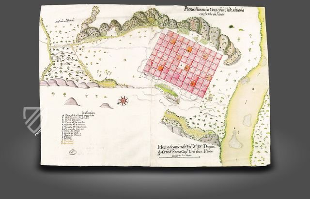
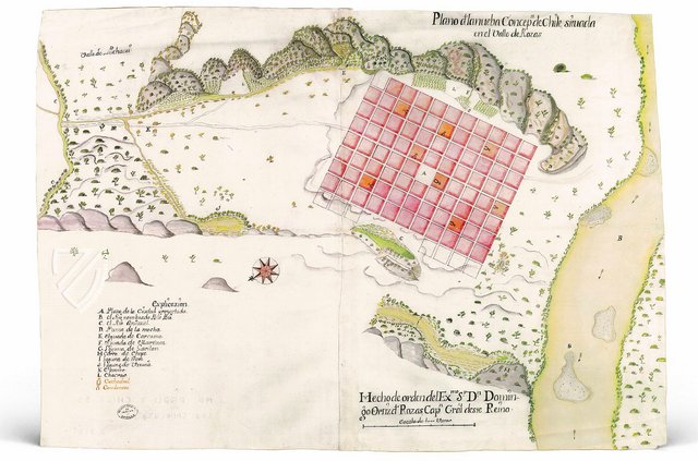
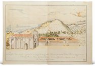
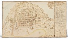
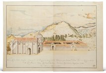
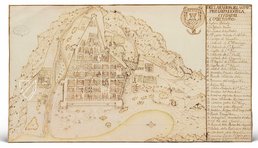
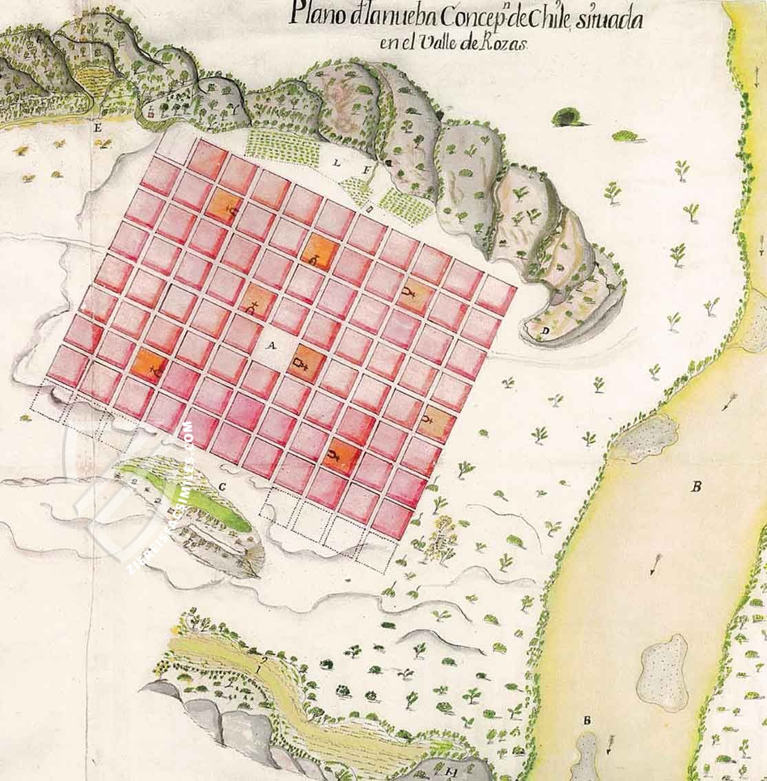
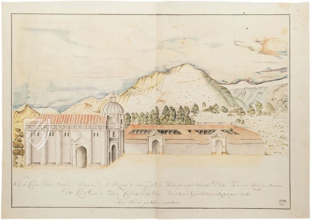
The last document is a view of the Convent of the Discalced Carmelite Order of San Rafael de Santiago de Chile from 1773. It is concerned with a view of a convent, which was consecrated in 1773, from the west, specifically from the tower of its founder, Don Luis Manuel de Zañartu. The watercolor shows the church and double cloister in the vast, flat plains of the Chilean landscape with hills and mountains in the background. Moreover, the compendium includes a map from 1752 with the plan for the new city of Concepción de Chile. Concepción is city founded in 1555 that was continuously destroyed by successive earthquakes over the years. The city was finally moved inland in 1754, in the Valle de Rosas. The third document is concerned with a plan of the city of Serena de Coquimbo from 1743. The city coat of arms and a large explanatory panel on the right margin adorn the map. Serena was founded in 1544, the city fortifications were newly invested in the 1730’s/ Today, the city is the most important center of tourism in the country.
Codicology
- Alternative Titles
- Paisajes y Urbanismo del Chile Colonial
Landschaft und Urbanisierung der Kolonie Chile
Paisajes urbanos y arquitectura en el Chile Colonial - Type
- Map on parchment
- Size / Format
- 3 maps / 75.0 × 54.0 cm 59.0 × 41.0 cm 40.0 × 23.0 cm
- Date
- 1743–1773
- Epochs
- Style
- Genre
- Language
Landscapes and Urbanism of Colonial Chile
Plan of the New Concepción de Chile
The city of Concepción de Chile was founded in 1550 and served as a base for the ongoing war against the Mapuche people that defined much of the history of Chile. Despite being besieged numerous times and even sacked once, the city suffered most from natural disasters, earthquakes, and tsunamis in particular. This map from 1752 shows a neat, quadratic city plan for a new building site on the banks of the Biobío River in the Valle de la Mocha, planned in the aftermath of the 1751 earthquake.
Landscapes and Urbanism of Colonial Chile
Convent of the Discalced Carmelites of San Rafael of Santiago de Chile
Monastic orders were among the most important institutions of Spain’s colonial empire in the Americas, serving both to Christianize and “civilize” the indigenous peoples. The Order of Discalced Carmelites, an offshoot of the mainstream Carmelites, have existed since 1580 and are focused on teaching prayer and giving spiritual direction. Their splendid cloister in the Chilean wilderness is artfully depicted here.
The cloister is situated in the mountains, which are visible in the background, but is still below the tree line. Dedicated on October 24th, 1777, the cloister was built in the Neoclassical-Colonial style and has a distinctly Roman look with courtyards, red tile roofs, rounded arches, pilasters, Corinthian columns, and a dome.
#1 Paisajes y Urbanismo del Chile Colonial
Language: Spanish
(under 1,000€)
- Treatises / Secular Books
- Apocalypses / Beatus
- Astronomy / Astrology
- Bestiaries
- Bibles / Gospels
- Chronicles / History / Law
- Geography / Maps
- Saints' Lives
- Islam / Oriental
- Judaism / Hebrew
- Single Leaf Collections
- Leonardo da Vinci
- Literature / Poetry
- Liturgical Manuscripts
- Medicine / Botany / Alchemy
- Music
- Mythology / Prophecies
- Psalters
- Other Religious Books
- Games / Hunting
- Private Devotion Books
- Other Genres
- Afghanistan
- Armenia
- Austria
- Belgium
- Belize
- Bosnia and Herzegovina
- China
- Colombia
- Costa Rica
- Croatia
- Cyprus
- Czech Republic
- Denmark
- Egypt
- El Salvador
- Ethiopia
- France
- Germany
- Greece
- Guatemala
- Honduras
- Hungary
- India
- Iran
- Iraq
- Israel
- Italy
- Japan
- Jordan
- Kazakhstan
- Kyrgyzstan
- Lebanon
- Liechtenstein
- Luxembourg
- Mexico
- Morocco
- Netherlands
- Palestine
- Panama
- Peru
- Poland
- Portugal
- Romania
- Russia
- Serbia
- Spain
- Sri Lanka
- Sweden
- Switzerland
- Syria
- Tajikistan
- Turkey
- Turkmenistan
- Ukraine
- United Kingdom
- United States
- Uzbekistan
- Vatican City
- A. Oosthoek, van Holkema & Warendorf
- Aboca Museum
- Ajuntament de Valencia
- Akademie Verlag
- Akademische Druck- u. Verlagsanstalt (ADEVA)
- Aldo Ausilio Editore - Bottega d’Erasmo
- Alecto Historical Editions
- Alkuin Verlag
- Almqvist & Wiksell
- Amilcare Pizzi
- Andreas & Andreas Verlagsbuchhandlung
- Archa 90
- Archiv Verlag
- Archivi Edizioni
- Arnold Verlag
- ARS
- Ars Magna
- Art Market
- ArtCodex
- AyN Ediciones
- Azimuth Editions
- Badenia Verlag
- Bärenreiter-Verlag
- Belser Verlag
- Belser Verlag / WK Wertkontor
- Benziger Verlag
- Bernardinum Wydawnictwo
- BiblioGemma
- Biblioteca Apostolica Vaticana (Vaticanstadt, Vaticanstadt)
- Bibliotheca Palatina Faksimile Verlag
- Bibliotheca Rara
- Boydell & Brewer
- Bramante Edizioni
- Bredius Genootschap
- Brepols Publishers
- British Library
- C. Weckesser
- Caixa Catalunya
- Canesi
- CAPSA, Ars Scriptoria
- Caratzas Brothers, Publishers
- Carus Verlag
- Casamassima Libri
- Centrum Cartographie Verlag GmbH
- Chavane Verlag
- Christian Brandstätter Verlag
- Circulo Cientifico
- Club Bibliófilo Versol
- Club du Livre
- CM Editores
- Collegium Graphicum
- Collezione Apocrifa Da Vinci
- Comissão Nacional para as Comemorações dos Descobrimentos Portugueses
- Coron Verlag
- Corvina
- CTHS
- D. S. Brewer
- Damon
- De Agostini/UTET
- De Nederlandsche Boekhandel
- De Schutter
- Deuschle & Stemmle
- Deutscher Verlag für Kunstwissenschaft
- DIAMM
- Dropmore Press
- Droz
- E. Schreiber Graphische Kunstanstalten
- Ediciones Boreal
- Ediciones Grial
- Ediclube
- Edições Inapa
- Edilan
- Editalia
- Edition Deuschle
- Edition Georg Popp
- Edition Leipzig
- Edition Libri Illustri
- Editiones Reales Sitios S. L.
- Éditions de l'Oiseau Lyre
- Editions Medicina Rara
- Editorial Casariego
- Editorial Mintzoa
- Editrice Antenore
- Editrice Velar
- Edizioni Edison
- Egeria, S.L.
- Eikon Editores
- Electa
- Emery Walker Limited
- Enciclopèdia Catalana
- Eos-Verlag
- Ephesus Publishing
- Ernst Battenberg
- Eugrammia Press
- Extraordinary Editions
- Fackelverlag
- Facsimila Art & Edition
- Facsimile Editions Ltd.
- Facsimilia Art & Edition Ebert KG
- Faksimile Verlag
- Feuermann Verlag
- Folger Shakespeare Library
- Franco Cosimo Panini Editore
- Friedrich Wittig Verlag
- Fundación Hullera Vasco-Leonesa
- G. Braziller
- Gabriele Mazzotta Editore
- Gebr. Mann Verlag
- Gesellschaft für graphische Industrie
- Getty Research Institute
- Giovanni Domenico de Rossi
- Giunti Editore
- Graffiti
- Grafica European Center of Fine Arts
- Guido Pressler
- Guillermo Blazquez
- Gustav Kiepenheuer
- H. N. Abrams
- Harrassowitz
- Harvard University Press
- Helikon
- Hendrickson Publishers
- Henning Oppermann
- Herder Verlag
- Hes & De Graaf Publishers
- Hoepli
- Holbein-Verlag
- Houghton Library
- Hugo Schmidt Verlag
- Idion Verlag
- Il Bulino, edizioni d'arte
- ILte
- Imago
- Insel Verlag
- Insel-Verlag Anton Kippenberger
- Instituto de Estudios Altoaragoneses
- Instituto Nacional de Antropología e Historia
- Introligatornia Budnik Jerzy
- Istituto dell'Enciclopedia Italiana - Treccani
- Istituto Ellenico di Studi Bizantini e Postbizantini
- Istituto Geografico De Agostini
- Istituto Poligrafico e Zecca dello Stato
- Italarte Art Establishments
- Jan Thorbecke Verlag
- Johnson Reprint Corporation
- Johnson Reprint Corporation
- Josef Stocker
- Josef Stocker-Schmid
- Jugoslavija
- Karl W. Hiersemann
- Kasper Straube
- Kaydeda Ediciones
- Kindler Verlag / Coron Verlag
- Kodansha International Ltd.
- Konrad Kölbl Verlag
- Kurt Wolff Verlag
- La Liberia dello Stato
- La Linea Editrice
- La Meta Editore
- Lambert Schneider
- Landeskreditbank Baden-Württemberg
- Leo S. Olschki
- Les Incunables
- Liber Artis
- Library of Congress
- Libreria Musicale Italiana
- Lichtdruck
- Lito Immagine Editore
- Lumen Artis
- Lund Humphries
- M. Moleiro Editor
- Maison des Sciences de l'homme et de la société de Poitiers
- Manuscriptum
- Martinus Nijhoff
- Maruzen-Yushodo Co. Ltd.
- MASA
- Massada Publishers
- McGraw-Hill
- Metropolitan Museum of Art
- Militos
- Millennium Liber
- Müller & Schindler
- Nahar - Stavit
- Nahar and Steimatzky
- National Library of Wales
- Neri Pozza
- Nova Charta
- Oceanum Verlag
- Odeon
- Omnia Arte
- Orbis Mediaevalis
- Orbis Pictus
- Österreichische Staatsdruckerei
- Oxford University Press
- Pageant Books
- Parzellers Buchverlag
- Patrimonio Ediciones
- Pattloch Verlag
- PIAF
- Pieper Verlag
- Plon-Nourrit et cie
- Poligrafiche Bolis
- Presses Universitaires de Strasbourg
- Prestel Verlag
- Princeton University Press
- Prisma Verlag
- Priuli & Verlucca, editori
- Pro Sport Verlag
- Propyläen Verlag
- Pytheas Books
- Quaternio Verlag Luzern
- Reales Sitios
- Recht-Verlag
- Reichert Verlag
- Reichsdruckerei
- Reprint Verlag
- Riehn & Reusch
- Roberto Vattori Editore
- Rosenkilde and Bagger
- Roxburghe Club
- Salerno Editrice
- Saltellus Press
- Sandoz
- Sarajevo Svjetlost
- Schöck ArtPrint Kft.
- Schulsinger Brothers
- Scolar Press
- Scrinium
- Scripta Maneant
- Scriptorium
- Shazar
- Siloé, arte y bibliofilia
- SISMEL - Edizioni del Galluzzo
- Sociedad Mexicana de Antropología
- Société des Bibliophiles & Iconophiles de Belgique
- Soncin Publishing
- Sorli Ediciones
- Stainer and Bell
- Studer
- Styria Verlag
- Sumptibus Pragopress
- Szegedi Tudomànyegyetem
- Taberna Libraria
- Tarshish Books
- Taschen
- Tempus Libri
- Testimonio Compañía Editorial
- TGB Limited Editions
- Thames and Hudson
- The Clear Vue Publishing Partnership Limited
- The Facsimile Codex
- The Folio Society
- The Marquess of Normanby
- The Richard III and Yorkist History Trust
- Tip.Le.Co
- TouchArt
- TREC Publishing House
- TRI Publishing Co.
- Trident Editore
- Tuliba Collection
- Typis Regiae Officinae Polygraphicae
- Union Verlag Berlin
- Universidad de Granada
- Universitaire Bibliotheken Leiden
- University of California Press
- University of Chicago Press
- Urs Graf
- Vallecchi
- Van Wijnen
- VCH, Acta Humaniora
- VDI Verlag
- VEB Deutscher Verlag für Musik
- Verlag Anton Pustet / Andreas Verlag
- Verlag Bibliophile Drucke Josef Stocker
- Verlag der Münchner Drucke
- Verlag für Regionalgeschichte
- Verlag Styria
- Vicent Garcia Editores
- W. Turnowski Ltd.
- W. Turnowsky
- Waanders Printers
- Wiener Mechitharisten-Congregation (Wien, Österreich)
- Wissenschaftliche Buchgesellschaft
- Wissenschaftliche Verlagsgesellschaft
- Wydawnictwo Dolnoslaskie
- Xuntanza Editorial
- Zakład Narodowy
- Zollikofer AG

