Mappa Mundi of Andreas Walsperger
")
Constance (Germany) — Ca. 1448
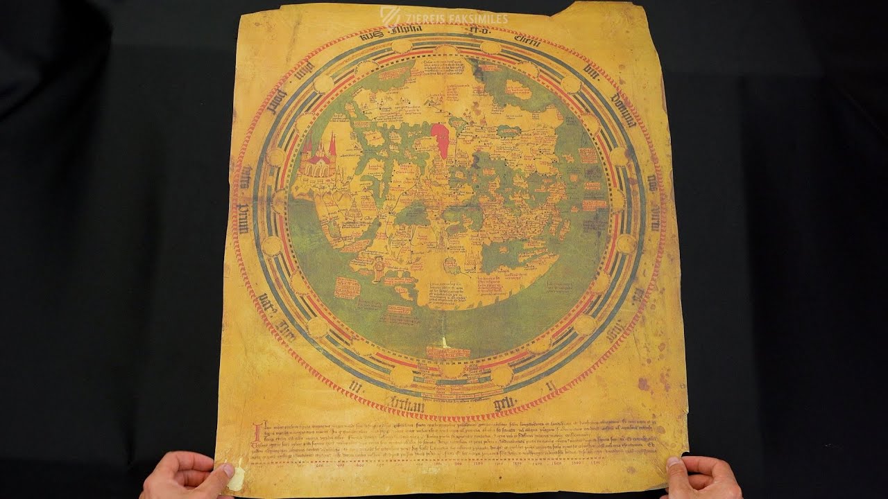
The Christian worldview in harmony with the new, scientific cartography: the large globe by the famous cartographer with Jerusalem in the center and Paradise as a large citadel in the east
Andreas Walsperger (b. ca. 1415) created this rare world map from the German-speaking area of Constance ca. 1448
The milestone of cartography artfully presents Earth as a disc framed by celestial spheres
Geographical South is shown at the top and North at the bottom, the holy city of Jerusalem is almost at the center of the disk
Mappa Mundi of Andreas Walsperger

")
")
")
")
")
")
")
(under 1,000€)
The Mappa Mundi of Andreas Walsperger is one of the few surviving medieval Mappae Mundi from the German-speaking world. Created in 1448 by the former Benedictine monk Andreas Walsperger (c. 1415–?) in Constance, it represents a true milestone in historical cartography. The circular, south-facing wheel map shows Jerusalem in the center and bears numerous fascinating inscriptions that provide an exciting insight into the Central European Christian worldview of the 15th century. Several concentric rings surround this world map, combining it with Ptolemy's astronomical teachings, depictions of planets, fixed stars, and the sun, as well as signs of the zodiac. A wonderful, gold-adorned fusion of traditional Christian cartography and scientific knowledge in rich colors.
Mappa Mundi of Andreas Walsperger
In the Christian idea of the world, Earth is at the center of seven celestial spheres. The image of the world was primarily based on the discoveries of the scholar Ptolemy. Parts of the medieval population envisaged the earth as a round disc with Jerusalem in the middle. Some Christian scholars disseminated this concept in scholarly works and above all with the help of illustrated maps. An especially beautiful map, which depicts the earth as a disc, is the mappa mundi – a schematic map of the medieval world view – by the Benedictine monk Andreas Walsperger. The map shows the roundness of the Earth and its surrounding celestial spheres. Zodiac symbols decorate the frame of the depiction.
The Creator of the World Map
Andreas Walsperger was born the son of a carpenter in Redkersburg ca. 1415. He became a monk at the Benedictine monastery of St. Peter in Salzburg in 1434, yet he left the monastery in 1442. Where else he might have lived, as well as the year of his death, has not been passed down. The Mappa mundi by Andreas Walsperger, which he made ca. 1448 in Constance, is one of the few original maps from the German-speaking area to survive. It is considered to be a milestone of historical cartography and is stored today in the Vatican Library.
An Artistic Tour de Force
The precious map is drawn in six natural colors and was embellished with elements of gold leaf. The majority of the orbis terrarium is taken up by the round field of the earth is aligned properly with geographic south at the top and north at the bottom. The Holy City of Jerusalem is found approximately in the center of the disc. The land is surrounded by the ocean. The seven celestial spheres are depicted as seven colored rings which are broken up by circles. These round forms represent the planets, the fixed stars, and the sun. The names of the zodiac signs and the winds at the margin of the earthly depiction are also noted. The map is an astounding document of the Christian worldview and represents a valuable tradition of earlier scientific findings.
Codicology
- Alternative Titles
- Weltkarte des Andreas Walsperger
Andreas Walsperger World Map - Type
- Map on parchment
- Size / Format
- 1 map / 75.0 × 57.7 cm
- Origin
- Germany
- Date
- Ca. 1448
- Epochs
- Style
- Genre
- Language
- Script
- Gothic Textura Quadrata
- Content
- Circular map of the known world with Jerusalem at the center and surrounded by circles representing the heavenly spheres and the starry sky
- Artist / School
- Andreas Walsperger
")
Mappa Mundi of Andreas Walsperger
The Holy Land
Although this Mappa Mundi has an unusual south-orientation, it nonetheless shows the world centered around Jerusalem. Surrounded by a wall with many towers, the holy city is shown alongside geographic features like the Sea of Galilee (mare galilee), Dead Sea (mare mortus), River Jordan, the Nile and its delta, and the literally depicted Red Sea.
The Muslim holy city of Mecca (melcha) is also depicted on the other side of Mt. Sinai (syne mons) in the Arabian Peninsula (Arabia regio). Important islands in the Mediterranean Sea like Cyprus (cypria), Crete (candia), and Rhodes (rodis) are shown with cities and towers, but Constantinople is represented only by a red dot – a symbol of the city’s declining fortunes as the Turks encircled it.
")
Mappa Mundi of Andreas Walsperger
A Unique World Map
Earth is presented here as a disc framed by seven celestial spheres in accordance with the Christian concept of the universe at the time. The map is based heavily on the work of the ancient astronomer Ptolemy, especially with regard to the shape of the continents. Although centered on the city of Jerusalem like most Mappae Mundi, it is south oriented.
This is a fine example of the transition from the schematic and conceptual maps of the Middle Ages to works of cartography that actually attempted to be practical geographic representations useful for navigation. Nonetheless, Walsperger’s map incorporates decorative features such as the large castle depicted in China, a departure from other maps in the period that place it in the north.
")
#1 Weltkarte des Andreas Walsperger
Language: German
(under 1,000€)
")
")
")
")
 – Cod. 594 – Österreichische Nationalbibliothek (Vienna, Austria)")
")

- Treatises / Secular Books
- Apocalypses / Beatus
- Astronomy / Astrology
- Bestiaries
- Bibles / Gospels
- Chronicles / History / Law
- Geography / Maps
- Saints' Lives
- Islam / Oriental
- Judaism / Hebrew
- Single Leaf Collections
- Leonardo da Vinci
- Literature / Poetry
- Liturgical Manuscripts
- Medicine / Botany / Alchemy
- Music
- Mythology / Prophecies
- Psalters
- Other Religious Books
- Games / Hunting
- Private Devotion Books
- Other Genres
- Afghanistan
- Armenia
- Austria
- Belgium
- Belize
- Bosnia and Herzegovina
- China
- Colombia
- Costa Rica
- Croatia
- Cyprus
- Czech Republic
- Denmark
- Egypt
- El Salvador
- Ethiopia
- France
- Germany
- Greece
- Guatemala
- Honduras
- Hungary
- India
- Iran
- Iraq
- Israel
- Italy
- Japan
- Jordan
- Kazakhstan
- Kyrgyzstan
- Lebanon
- Liechtenstein
- Luxembourg
- Mexico
- Morocco
- Netherlands
- Palestine
- Panama
- Peru
- Poland
- Portugal
- Romania
- Russia
- Serbia
- Spain
- Sri Lanka
- Sweden
- Switzerland
- Syria
- Tajikistan
- Turkey
- Turkmenistan
- Ukraine
- United Kingdom
- United States
- Uzbekistan
- Vatican City
- A. Oosthoek, van Holkema & Warendorf
- Aboca Museum
- Ajuntament de Valencia
- Akademie Verlag
- Akademische Druck- u. Verlagsanstalt (ADEVA)
- Aldo Ausilio Editore - Bottega d’Erasmo
- Alecto Historical Editions
- Alkuin Verlag
- Almqvist & Wiksell
- Amilcare Pizzi
- Andreas & Andreas Verlagsbuchhandlung
- Archa 90
- Archiv Verlag
- Archivi Edizioni
- Arnold Verlag
- ARS
- Ars Magna
- Ars Millenii
- Art Market
- ArtCodex
- AyN Ediciones
- Azimuth Editions
- Badenia Verlag
- Bärenreiter-Verlag
- Belser Verlag
- Belser Verlag / WK Wertkontor
- Benziger Verlag
- Bernardinum Wydawnictwo
- BiblioGemma
- Biblioteca Apostolica Vaticana (Vaticanstadt, Vaticanstadt)
- Bibliotheca Palatina Faksimile Verlag
- Bibliotheca Rara
- Boydell & Brewer
- Bramante Edizioni
- Bredius Genootschap
- Brepols Publishers
- British Library
- Brokarte
- C. Weckesser
- Caixa Catalunya
- Canesi
- CAPSA, Ars Scriptoria
- Caratzas Brothers, Publishers
- Carus Verlag
- Casamassima Libri
- Centrum Cartographie Verlag GmbH
- Chavane Verlag
- Christian Brandstätter Verlag
- Circulo Cientifico
- Club Bibliófilo Versol
- Club du Livre
- Club Internacional del Libro
- CM Editores
- Collegium Graphicum
- Collezione Apocrifa Da Vinci
- Comissão Nacional para as Comemorações dos Descobrimentos Portugueses
- Coron Verlag
- Corvina
- CTHS
- D. S. Brewer
- Damon
- De Agostini/UTET
- De Nederlandsche Boekhandel
- De Schutter
- Deuschle & Stemmle
- Deutscher Verlag für Kunstwissenschaft
- DIAMM
- Dropmore Press
- Droz
- E. Schreiber Graphische Kunstanstalten
- Ediciones Boreal
- Ediciones Grial
- Ediclube
- Edições Inapa
- Edilan
- Editalia
- Edition Deuschle
- Edition Georg Popp
- Edition Leipzig
- Edition Libri Illustri
- Editiones Reales Sitios S. L.
- Éditions de l'Oiseau Lyre
- Editions Medicina Rara
- Editorial Casariego
- Editorial Mintzoa
- Editrice Antenore
- Editrice Velar
- Edizioni Edison
- Egeria, S.L.
- Eikon Editores
- Electa
- Emery Walker Limited
- Enciclopèdia Catalana
- Eos-Verlag
- Ephesus Publishing
- Ernst Battenberg
- Eugrammia Press
- Extraordinary Editions
- Fackelverlag
- Facsimila Art & Edition
- Facsimile Editions Ltd.
- Facsimilia Art & Edition Ebert KG
- Faksimile Verlag
- Feuermann Verlag
- Folger Shakespeare Library
- Franco Cosimo Panini Editore
- Friedrich Wittig Verlag
- Fundación Hullera Vasco-Leonesa
- G. Braziller
- Gabriele Mazzotta Editore
- Gebr. Mann Verlag
- Gesellschaft für graphische Industrie
- Getty Research Institute
- Giovanni Domenico de Rossi
- Giunti Editore
- Goldenmark Librarium
- Graffiti
- Grafica European Center of Fine Arts
- Guido Pressler
- Guillermo Blazquez
- Gustav Kiepenheuer
- H. N. Abrams
- Harrassowitz
- Harvard University Press
- Helikon
- Hendrickson Publishers
- Henning Oppermann
- Herder Verlag
- Hes & De Graaf Publishers
- Hoepli
- Holbein-Verlag
- Houghton Library
- Hugo Schmidt Verlag
- Hungarian Academy of Sciences
- Idion Verlag
- Il Bulino, edizioni d'arte
- ILte
- Imago
- Insel Verlag
- Insel-Verlag Anton Kippenberger
- Instituto de Estudios Altoaragoneses
- Instituto Nacional de Antropología e Historia
- Introligatornia Budnik Jerzy
- Istituto dell'Enciclopedia Italiana - Treccani
- Istituto Ellenico di Studi Bizantini e Postbizantini
- Istituto Geografico De Agostini
- Istituto Poligrafico e Zecca dello Stato
- Italarte Art Establishments
- Jaca Book
- Jan Thorbecke Verlag
- Johnson Reprint Corporation
- Johnson Reprint Corporation
- Jos. Baer
- Josef Stocker
- Josef Stocker-Schmid
- Jugoslavija
- Karl W. Hiersemann
- Kasper Straube
- Kaydeda Ediciones
- Kindler Verlag / Coron Verlag
- Kodansha International Ltd.
- Konrad Kölbl Verlag
- Kurt Wolff Verlag
- La Liberia dello Stato
- La Linea Editrice
- La Meta Editore
- Lambert Schneider
- Landeskreditbank Baden-Württemberg
- Leo S. Olschki
- Les Incunables
- Liber Artis
- Library of Congress
- Libreria Musicale Italiana
- Lichtdruck
- Lito Immagine Editore
- Lumen Artis
- Lund Humphries
- M. Moleiro Editor
- Maison des Sciences de l'homme et de la société de Poitiers
- Manuscriptum
- Martinus Nijhoff
- Maruzen-Yushodo Co. Ltd.
- MASA
- Massada Publishers
- McGraw-Hill
- Metropolitan Museum of Art
- Militos
- Millennium Liber
- Müller & Schindler
- Nahar - Stavit
- Nahar and Steimatzky
- National Library of Wales
- Neri Pozza
- Nova Charta
- Oceanum Verlag
- Odeon
- Omnia Arte
- Orbis Mediaevalis
- Orbis Pictus
- Österreichische Staatsdruckerei
- Oxford University Press
- Pageant Books
- Parzellers Buchverlag
- Patrimonio Ediciones
- Pattloch Verlag
- PIAF
- Pieper Verlag
- Plon-Nourrit et cie
- Poligrafiche Bolis
- Presses Universitaires de Strasbourg
- Prestel Verlag
- Princeton University Press
- Prisma Verlag
- Priuli & Verlucca, editori
- Pro Sport Verlag
- Propyläen Verlag
- Pytheas Books
- Quaternio Verlag Luzern
- Reales Sitios
- Recht-Verlag
- Reichert Verlag
- Reichsdruckerei
- Reprint Verlag
- Riehn & Reusch
- Roberto Vattori Editore
- Rosenkilde and Bagger
- Roxburghe Club
- Salerno Editrice
- Saltellus Press
- Sandoz
- Sarajevo Svjetlost
- Schöck ArtPrint Kft.
- Schulsinger Brothers
- Scolar Press
- Scrinium
- Scripta Maneant
- Scriptorium
- Shazar
- Siloé, arte y bibliofilia
- SISMEL - Edizioni del Galluzzo
- Sociedad Mexicana de Antropología
- Société des Bibliophiles & Iconophiles de Belgique
- Soncin Publishing
- Sorli Ediciones
- Stainer and Bell
- Studer
- Styria Verlag
- Sumptibus Pragopress
- Szegedi Tudomànyegyetem
- Taberna Libraria
- Tarshish Books
- Taschen
- Tempus Libri
- Testimonio Compañía Editorial
- TGB Limited Editions
- Thames and Hudson
- The Clear Vue Publishing Partnership Limited
- The Facsimile Codex
- The Folio Society
- The Marquess of Normanby
- The Orphan Hospital Ward of Israel
- The Richard III and Yorkist History Trust
- The Warburg Institute
- Tip.Le.Co
- TouchArt
- TREC Publishing House
- TRI Publishing Co.
- Trident Editore
- Tuliba Collection
- Typis Regiae Officinae Polygraphicae
- Union Verlag Berlin
- Universidad de Granada
- Universitaire Bibliotheken Leiden
- University of California Press
- University of Chicago Press
- Urs Graf
- Vallecchi
- Van Wijnen
- VCH, Acta Humaniora
- VDI Verlag
- VEB Deutscher Verlag für Musik
- Verein Schweizerischer Lithographie-Besitzer
- Verlag Anton Pustet / Andreas Verlag
- Verlag Bibliophile Drucke Josef Stocker
- Verlag der Münchner Drucke
- Verlag für Regionalgeschichte
- Verlag Styria
- Vicent Garcia Editores
- W. Turnowsky
- Waanders Printers
- Wiener Mechitharisten-Congregation (Wien, Österreich)
- Wissenschaftliche Buchgesellschaft
- Wissenschaftliche Verlagsgesellschaft
- Wydawnictwo Dolnoslaskie
- Xuntanza Editorial
- Zakład Narodowy
- Zollikofer AG