Sea Map of Iehuda Ben Zara
")
Alexandria (Egypt) — 1497
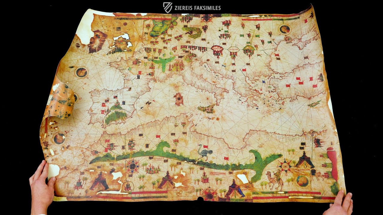
The largest surviving portolan map in the world, illuminated with magnificent colors and gold leaf: the Mediterranean Sea in the amazing precision of the most important Egyptian cartographer of the Renaissance, Iehuda ben Zara
The largest surviving portolan chart in the world originated ca. 1407 in Alexandria
The most famous Egyptian geographer of the Renaissance, Iehuda ben Zara, used high quality colors and gold leaf
The map shows the Mediterranean with precision that is still quite amazing today
Sea Map of Iehuda Ben Zara

")
")
")
")
")
")
")
")
")
")
(1,000€ - 3,000€)
The Sea Map of Iehuda Ben Zara was produced in the ancient city of Alexandria in 1497. It is the largest surviving portolan chart in the world and records important nautical information in various colors. Aside from practical information for navigators including flags, compass roses, wind directions, and known perils, the map is richly embellished with cities, tents, people, animals, trees, and other delightful details that bring the Mediterranean world in the late-15th century to life. Influences from the famous Mallorcan school of mapmakers can also be found in the work. This precious nautical chart was additionally adorned with elements of gold leaf by the Jewish master Lehuda Ben Zara.
Sea Map of Iehuda Ben Zara
The term “portolan” originally indicates a book with nautical information such as landmarks, light houses, currents, and harbor conditions. The employment of this term is first documented in the year 1285. From the 16th century on, the meaning of this term was expanded and henceforth included not only the text of the work, but also the accompanying sea charts. Today the specialized sea charts denote a specific type as “portolan charts.” An example of this is the Sea Map of Iehuda Ben Zara. The colorful and gold-adorned chart** is one of the most valuable maps in the Vatican Library today.
A Masterwork of Nautical Science
The Sea Map of Iehuda Ben Zaraarose ca. 1497 and is the largest portolan chart still in existence. The rare chart was painted with the utmost precision on the skin of a single animal. It shows the world, as it was known by the educated of the Renaissance. A primary feature is the visible network of lines that aided maneuvering by means of a compass. Dangerous passages were highlighted by the chart and commented on with inscriptions like “Pay Attention!” or “Eyes Open!” The sea map bespeaks the high aptitude of the master, who worked unbelievably accurately and realistically without the aids and appliances of our modern technology.
High Quality Embellishment
Iehuda Ben Zara is probably the most famous Egyptian geographer of the Renaissance. He made his sea map in Alexandria, a cultural stronghold of Egypt. He employed high quality colors and gold leaf. Embarkation points are registered in various colors. Thus the commercial significance of the respective ports was indicated. The cardinal directions are recorded with black ink. He differentiated between various wind currents, which were drawn with the help of green and red lines. As a result he retained a traditional coloration that remained unchanged for many centuries.
Codicology
- Alternative Titles
- Sea Chart of Iehuda Ben Zara
Seekarte des Iehuda ben Zara
Nautical Chart of Jehuda ben Zara
Carta Nautica di Iehuda Ben Zara - Type
- Map on parchment
- Size / Format
- 1 map / 92.5 × 67.0 cm
- Origin
- Egypt
- Date
- 1497
- Epochs
- Style
- Genre
- Language
- Illustrations
- The map is decorated with figural sceneries, cityscapes, colored landmarks, various flags and banners, as well as wind roses and portrait medallions
- Content
- Portolan map emphasizing the mediterranean area
- Artist / School
- Iehuda ben Zara (author)
")
Sea Map of Iehuda Ben Zara
The Egyptian Desert
Here in the lower-right corner we can see a tent and compass rose flanked by a camel carrying its rider off into the Sahara and an elephant making its way to cities on the shores of the Red Sea. It is the Egyptian desert to the south of the city. The Nile is shown flowing north to Alexandria where the map was created, alongside which a human head represents one of the classical compass winds. Artists often used margins and other open spaces to give an impression of local conditions.
")
Sea Map of Iehuda Ben Zara
Map of the Mediterranean
This splendid map of the Mediterranean, which is cut off before it reaches the coastline of the Levant; the eastern third of the Black Sea is similarly incomplete. However, the rest of the map is surprisingly accurate except for the exaggerated size of the island of Ireland. Most of the waters are uncolored save for the Red Sea, depicted literally, and the Baltic Sea, which is painted blue.
Some of the typical compass roses are replaced by portraits in profile, which all appear to depict the same person dressed in red with short, light brown hair. Aside from other typical ornaments such as cities with flags, one can see numerous palm trees as well as an accurately depicted ostrich walking along the green mountain range in North Africa as well as an elephant on the banks of the Nile River.
")
#1 Seekarte des Iehuda ben Zara
(1,000€ - 3,000€)
")
")
")
")
")
")

- Treatises / Secular Books
- Apocalypses / Beatus
- Astronomy / Astrology
- Bestiaries
- Bibles / Gospels
- Chronicles / History / Law
- Geography / Maps
- Saints' Lives
- Islam / Oriental
- Judaism / Hebrew
- Single Leaf Collections
- Leonardo da Vinci
- Literature / Poetry
- Liturgical Manuscripts
- Medicine / Botany / Alchemy
- Music
- Mythology / Prophecies
- Psalters
- Other Religious Books
- Games / Hunting
- Private Devotion Books
- Other Genres
- Afghanistan
- Armenia
- Austria
- Belgium
- Belize
- Bosnia and Herzegovina
- China
- Colombia
- Costa Rica
- Croatia
- Cyprus
- Czech Republic
- Denmark
- Egypt
- El Salvador
- Ethiopia
- France
- Germany
- Greece
- Guatemala
- Honduras
- Hungary
- India
- Iran
- Iraq
- Israel
- Italy
- Japan
- Jordan
- Kazakhstan
- Kyrgyzstan
- Lebanon
- Liechtenstein
- Luxembourg
- Mexico
- Morocco
- Netherlands
- Palestine
- Panama
- Peru
- Poland
- Portugal
- Romania
- Russia
- Serbia
- Spain
- Sri Lanka
- Sweden
- Switzerland
- Syria
- Tajikistan
- Turkey
- Turkmenistan
- Ukraine
- United Kingdom
- United States
- Uzbekistan
- Vatican City
- A. Oosthoek, van Holkema & Warendorf
- Aboca Museum
- Ajuntament de Valencia
- Akademie Verlag
- Akademische Druck- u. Verlagsanstalt (ADEVA)
- Aldo Ausilio Editore - Bottega d’Erasmo
- Alecto Historical Editions
- Alkuin Verlag
- Almqvist & Wiksell
- Amilcare Pizzi
- Andreas & Andreas Verlagsbuchhandlung
- Archa 90
- Archiv Verlag
- Archivi Edizioni
- Arnold Verlag
- ARS
- Ars Magna
- Ars Millenii
- Art Market
- ArtCodex
- AyN Ediciones
- Azimuth Editions
- Badenia Verlag
- Bärenreiter-Verlag
- Belser Verlag
- Belser Verlag / WK Wertkontor
- Benziger Verlag
- Bernardinum Wydawnictwo
- BiblioGemma
- Biblioteca Apostolica Vaticana (Vaticanstadt, Vaticanstadt)
- Bibliotheca Palatina Faksimile Verlag
- Bibliotheca Rara
- Boydell & Brewer
- Bramante Edizioni
- Bredius Genootschap
- Brepols Publishers
- British Library
- Brokarte
- C. Weckesser
- Caixa Catalunya
- Canesi
- CAPSA, Ars Scriptoria
- Caratzas Brothers, Publishers
- Carus Verlag
- Casamassima Libri
- Centrum Cartographie Verlag GmbH
- Chavane Verlag
- Christian Brandstätter Verlag
- Circulo Cientifico
- Club Bibliófilo Versol
- Club du Livre
- Club Internacional del Libro
- CM Editores
- Collegium Graphicum
- Collezione Apocrifa Da Vinci
- Comissão Nacional para as Comemorações dos Descobrimentos Portugueses
- Coron Verlag
- Corvina
- CTHS
- D. S. Brewer
- Damon
- De Agostini/UTET
- De Nederlandsche Boekhandel
- De Schutter
- Deuschle & Stemmle
- Deutscher Verlag für Kunstwissenschaft
- DIAMM
- Dropmore Press
- Droz
- E. Schreiber Graphische Kunstanstalten
- Ediciones Boreal
- Ediciones Grial
- Ediclube
- Edições Inapa
- Edilan
- Editalia
- Edition Deuschle
- Edition Georg Popp
- Edition Leipzig
- Edition Libri Illustri
- Editiones Reales Sitios S. L.
- Éditions de l'Oiseau Lyre
- Editions Medicina Rara
- Editorial Casariego
- Editorial Mintzoa
- Editrice Antenore
- Editrice Velar
- Edizioni Edison
- Egeria, S.L.
- Eikon Editores
- Electa
- Emery Walker Limited
- Enciclopèdia Catalana
- Eos-Verlag
- Ephesus Publishing
- Ernst Battenberg
- Eugrammia Press
- Extraordinary Editions
- Fackelverlag
- Facsimila Art & Edition
- Facsimile Editions Ltd.
- Facsimilia Art & Edition Ebert KG
- Faksimile Verlag
- Feuermann Verlag
- Folger Shakespeare Library
- Franco Cosimo Panini Editore
- Friedrich Wittig Verlag
- Fundación Hullera Vasco-Leonesa
- G. Braziller
- Gabriele Mazzotta Editore
- Gebr. Mann Verlag
- Gesellschaft für graphische Industrie
- Getty Research Institute
- Giovanni Domenico de Rossi
- Giunti Editore
- Goldenmark Librarium
- Graffiti
- Grafica European Center of Fine Arts
- Guido Pressler
- Guillermo Blazquez
- Gustav Kiepenheuer
- H. N. Abrams
- Harrassowitz
- Harvard University Press
- Helikon
- Hendrickson Publishers
- Henning Oppermann
- Herder Verlag
- Hes & De Graaf Publishers
- Hoepli
- Holbein-Verlag
- Houghton Library
- Hugo Schmidt Verlag
- Hungarian Academy of Sciences
- Idion Verlag
- Il Bulino, edizioni d'arte
- ILte
- Imago
- Insel Verlag
- Insel-Verlag Anton Kippenberger
- Instituto de Estudios Altoaragoneses
- Instituto Nacional de Antropología e Historia
- Introligatornia Budnik Jerzy
- Istituto dell'Enciclopedia Italiana - Treccani
- Istituto Ellenico di Studi Bizantini e Postbizantini
- Istituto Geografico De Agostini
- Istituto Poligrafico e Zecca dello Stato
- Italarte Art Establishments
- Jaca Book
- Jan Thorbecke Verlag
- Johnson Reprint Corporation
- Johnson Reprint Corporation
- Jos. Baer
- Josef Stocker
- Josef Stocker-Schmid
- Jugoslavija
- Karl W. Hiersemann
- Kasper Straube
- Kaydeda Ediciones
- Kindler Verlag / Coron Verlag
- Kodansha International Ltd.
- Konrad Kölbl Verlag
- Kurt Wolff Verlag
- La Liberia dello Stato
- La Linea Editrice
- La Meta Editore
- Lambert Schneider
- Landeskreditbank Baden-Württemberg
- Leo S. Olschki
- Les Incunables
- Liber Artis
- Library of Congress
- Libreria Musicale Italiana
- Lichtdruck
- Lito Immagine Editore
- Lumen Artis
- Lund Humphries
- M. Moleiro Editor
- Maison des Sciences de l'homme et de la société de Poitiers
- Manuscriptum
- Martinus Nijhoff
- Maruzen-Yushodo Co. Ltd.
- MASA
- Massada Publishers
- McGraw-Hill
- Metropolitan Museum of Art
- Militos
- Millennium Liber
- Müller & Schindler
- Nahar - Stavit
- Nahar and Steimatzky
- National Library of Wales
- Neri Pozza
- Nova Charta
- Oceanum Verlag
- Odeon
- Omnia Arte
- Orbis Mediaevalis
- Orbis Pictus
- Österreichische Staatsdruckerei
- Oxford University Press
- Pageant Books
- Parzellers Buchverlag
- Patrimonio Ediciones
- Pattloch Verlag
- PIAF
- Pieper Verlag
- Plon-Nourrit et cie
- Poligrafiche Bolis
- Presses Universitaires de Strasbourg
- Prestel Verlag
- Princeton University Press
- Prisma Verlag
- Priuli & Verlucca, editori
- Pro Sport Verlag
- Propyläen Verlag
- Pytheas Books
- Quaternio Verlag Luzern
- Reales Sitios
- Recht-Verlag
- Reichert Verlag
- Reichsdruckerei
- Reprint Verlag
- Riehn & Reusch
- Roberto Vattori Editore
- Rosenkilde and Bagger
- Roxburghe Club
- Salerno Editrice
- Saltellus Press
- Sandoz
- Sarajevo Svjetlost
- Schöck ArtPrint Kft.
- Schulsinger Brothers
- Scolar Press
- Scrinium
- Scripta Maneant
- Scriptorium
- Shazar
- Siloé, arte y bibliofilia
- SISMEL - Edizioni del Galluzzo
- Sociedad Mexicana de Antropología
- Société des Bibliophiles & Iconophiles de Belgique
- Soncin Publishing
- Sorli Ediciones
- Stainer and Bell
- Studer
- Styria Verlag
- Sumptibus Pragopress
- Szegedi Tudomànyegyetem
- Taberna Libraria
- Tarshish Books
- Taschen
- Tempus Libri
- Testimonio Compañía Editorial
- TGB Limited Editions
- Thames and Hudson
- The Clear Vue Publishing Partnership Limited
- The Facsimile Codex
- The Folio Society
- The Marquess of Normanby
- The Orphan Hospital Ward of Israel
- The Richard III and Yorkist History Trust
- The Warburg Institute
- Tip.Le.Co
- TouchArt
- TREC Publishing House
- TRI Publishing Co.
- Trident Editore
- Tuliba Collection
- Typis Regiae Officinae Polygraphicae
- Union Verlag Berlin
- Universidad de Granada
- Universitaire Bibliotheken Leiden
- University of California Press
- University of Chicago Press
- Urs Graf
- Vallecchi
- Van Wijnen
- VCH, Acta Humaniora
- VDI Verlag
- VEB Deutscher Verlag für Musik
- Verein Schweizerischer Lithographie-Besitzer
- Verlag Anton Pustet / Andreas Verlag
- Verlag Bibliophile Drucke Josef Stocker
- Verlag der Münchner Drucke
- Verlag für Regionalgeschichte
- Verlag Styria
- Vicent Garcia Editores
- W. Turnowsky
- Waanders Printers
- Wiener Mechitharisten-Congregation (Wien, Österreich)
- Wissenschaftliche Buchgesellschaft
- Wissenschaftliche Verlagsgesellschaft
- Wydawnictwo Dolnoslaskie
- Xuntanza Editorial
- Zakład Narodowy
- Zollikofer AG