Vatican Ptolemy
")
Florence (Italy) — 15th century
Created almost 1,500 years after Ptolemy: a revised new edition of the ancient standard work in a brilliant cartographic manuscript by the Vatican astronomer Nicolaus Germanus for Pope Paul III.
In the late 15th century, geographer and astrologer Nicolaus Germanus (ca. 1420 – ca. 1490) was employed at the Vatican
His work is dedicated to Pope Paul III (1468–1549) and revised, updated, and expanded Ptolemy's maps
A spectacular specimen of the time when the 2nd century work by Ptolemy was rediscovered
Vatican Ptolemy

")
")
(3,000€ - 7,000€)
In the late 15th century, geographer and astrologer Nicolaus Germanus, who was employed by the Vatican, completed the maps for this famous manuscript: the so-called Vatican Ptolemy. This geographic work is named after the ancient geographer and Renaissance man Claudius Ptolemy, who is considered to be the founder of modern cartography. The original Greek text of the Cosmographia by Claudius Ptolemy was translated into Latin by Jacopo Angeli da Scarpezia and was also illustrated and furnished entirely in the exquisite style of the Renaissance with the most precious materials and the greatest artistry. Dedicated to Pope Paul II, the Vatican Ptolemy unites this impressive artistic quality with a comprehensive image of the world as it was known at that time!
Vatican Ptolemy
In the late 15th century, geographer and astrologer Nicolaus Germanus, who was employed by the Vatican, completed the maps for this famous manuscript: the so-called Vatican Ptolemy. This geographic work is named after the ancient geographer and Renaissance man Claudius Ptolemy, who is considered to be the founder of modern cartography. The original Greek text of the Cosmographia by Claudius Ptolemy was translated into Latin by Jacopo Angeli da Scarpezia and was also illustrated and furnished entirely in the exquisite style of the Renaissance ** with the most precious materials and the greatest artistry. Dedicated to **Pope Paul II, the Vatican Ptolemy unites this impressive artistic quality with a comprehensive image of the world as it was known at that time!
A Famous Ancient Geographer
Cosmography in the Middle Ages was the science of describing the earth and space. The Vatican Ptolemy is one of the famous Ptolemy manuscripts of the Renaissance, named after the founder of modern cartography: Claudius Ptolemy. The famous Greek geographer from the 2nd century, whose portrait on the second page of the manuscript shows him with a book and compass in his hands, composed numerous standard works as a mathematician, geographer, astronomer, astrologer, music theorist, and philosopher. His Cosmographia is a comprehensive geographical work responsible for the fame that he enjoys to this day. Ptolemy was nevertheless long forgotten and, like so many intellectual giants of antiquity, was first rediscovered during the time of the Renaissance.
A Papal Treasure
Ptolemy’s Cosmographia was a significant geographical work, which visualizes the known world at that time and thus was of great value for seafarers and merchants. Codex Urb. Lat. 274 of the Biblioteca Apostolica Vaticana is replete with informative content and is a gem of Renaissance illumination. The manuscript, which probably originates from 15th century Florence, was furnished with only the finest of materials. A lavish application of gold leaf on noble parchment accounts for the additional appeal of the geographic manuscript. The Vatican Ptolemy contains, inter alia, a dedication to Pope Paul II (1417–1471), attests to the fact that this jewel must have been made for a truly important patron.
Ancient Work, Modern Maps
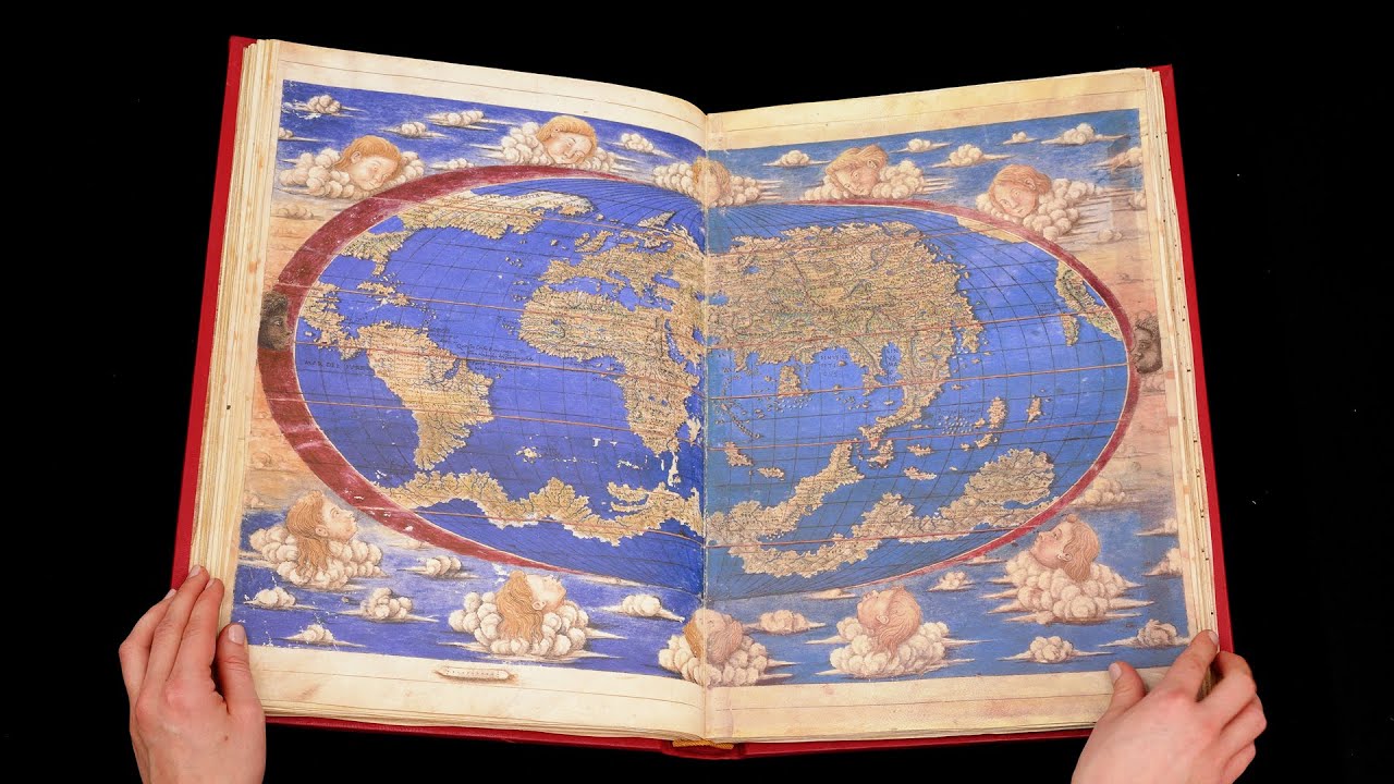
The 30 maps of the geographical overview work originates from Nicolaus Germanus, a geographer who, among others, made two globes for the Vatican in the year 1477. The maps by Nicolaus Germanus illustrate and accompany the text of the Cosmographia, which was translated from the original Greek into Latin by Jacopo Angeli da Scarpezia. The 266, 44.4 x 29.9 cm pages of the Vatican Ptolemy contain a total of 30, mostly multi-page maps: a map of the Old World, 13 maps of Europe, 4 cartographical depictions of Africa and 12 of Asia. Additionally, Ptolemy’s maps were revised, expanded, and brought up to date. New maps came to be in this way, e.g. of Spain, northern Europe and Italy. Additionally, the work was appended with an additional map: a current world map with newly discovered regions, e.g. America.
Codicology
- Alternative Titles
- Vaticanische Cosmographia des Claudius Ptolemäus
Tolomeo Vaticano
Cosmographia of Ptolemy
Vatican Ptolemys
Vatikan-Cosmographia des Claudius Ptolomaeus
Cosmographia des Claudius Ptolomäus
Geographia de Ptolomeo
Cosmografia di Tolomeo - Type
- Map on parchment
- Size / Format
- 266 pages / 44.4 × 29.9 cm
- Origin
- Italy
- Date
- 15th century
- Epochs
- Style
- Genre
- Language
- Illustrations
- 30 maps: a map of the Old World, 13 maps of Europe (with the addition of three new ones: modern Spain, Northern Europe, modern Italy, more precise and elaborate than those created by Ptolemy), 4 of Africa and 12 of Asia, with maps often covering several pages
- Patron
- János Vitéz, Archbishop of Esztergom
- Previous Owners
- Pope Alexander VII
")
#1 Tolomeo Vaticano
Language: Spanish
(3,000€ - 7,000€)
")
")
")
")
")
")

- Treatises / Secular Books
- Apocalypses / Beatus
- Astronomy / Astrology
- Bestiaries
- Bibles / Gospels
- Chronicles / History / Law
- Geography / Maps
- Saints' Lives
- Islam / Oriental
- Judaism / Hebrew
- Single Leaf Collections
- Leonardo da Vinci
- Literature / Poetry
- Liturgical Manuscripts
- Medicine / Botany / Alchemy
- Music
- Mythology / Prophecies
- Psalters
- Other Religious Books
- Games / Hunting
- Private Devotion Books
- Other Genres
- Afghanistan
- Armenia
- Austria
- Belgium
- Belize
- Bosnia and Herzegovina
- China
- Colombia
- Costa Rica
- Croatia
- Cyprus
- Czech Republic
- Denmark
- Egypt
- El Salvador
- Ethiopia
- France
- Germany
- Greece
- Guatemala
- Honduras
- Hungary
- India
- Iran
- Iraq
- Israel
- Italy
- Japan
- Jordan
- Kazakhstan
- Kyrgyzstan
- Lebanon
- Liechtenstein
- Luxembourg
- Mexico
- Morocco
- Netherlands
- Palestine
- Panama
- Peru
- Poland
- Portugal
- Romania
- Russia
- Serbia
- Spain
- Sri Lanka
- Sweden
- Switzerland
- Syria
- Tajikistan
- Turkey
- Turkmenistan
- Ukraine
- United Kingdom
- United States
- Uzbekistan
- Vatican City
- A. Oosthoek, van Holkema & Warendorf
- Aboca Museum
- Ajuntament de Valencia
- Akademie Verlag
- Akademische Druck- u. Verlagsanstalt (ADEVA)
- Aldo Ausilio Editore - Bottega d’Erasmo
- Alecto Historical Editions
- Alkuin Verlag
- Almqvist & Wiksell
- Amilcare Pizzi
- Andreas & Andreas Verlagsbuchhandlung
- Archa 90
- Archiv Verlag
- Archivi Edizioni
- Arnold Verlag
- ARS
- Ars Magna
- Ars Millenii
- Art Market
- ArtCodex
- AyN Ediciones
- Azimuth Editions
- Badenia Verlag
- Bärenreiter-Verlag
- Belser Verlag
- Belser Verlag / WK Wertkontor
- Benziger Verlag
- Bernardinum Wydawnictwo
- BiblioGemma
- Biblioteca Apostolica Vaticana (Vaticanstadt, Vaticanstadt)
- Bibliotheca Palatina Faksimile Verlag
- Bibliotheca Rara
- Boydell & Brewer
- Bramante Edizioni
- Bredius Genootschap
- Brepols Publishers
- British Library
- Brokarte
- C. Weckesser
- Caixa Catalunya
- Canesi
- CAPSA, Ars Scriptoria
- Caratzas Brothers, Publishers
- Carus Verlag
- Casamassima Libri
- Centrum Cartographie Verlag GmbH
- Chavane Verlag
- Christian Brandstätter Verlag
- Circulo Cientifico
- Club Bibliófilo Versol
- Club du Livre
- Club Internacional del Libro
- CM Editores
- Collegium Graphicum
- Collezione Apocrifa Da Vinci
- Comissão Nacional para as Comemorações dos Descobrimentos Portugueses
- Coron Verlag
- Corvina
- CTHS
- D. S. Brewer
- Damon
- De Agostini/UTET
- De Nederlandsche Boekhandel
- De Schutter
- Deuschle & Stemmle
- Deutscher Verlag für Kunstwissenschaft
- DIAMM
- Dropmore Press
- Droz
- E. Schreiber Graphische Kunstanstalten
- Ediciones Boreal
- Ediciones Grial
- Ediclube
- Edições Inapa
- Edilan
- Editalia
- Edition Deuschle
- Edition Georg Popp
- Edition Leipzig
- Edition Libri Illustri
- Editiones Reales Sitios S. L.
- Éditions de l'Oiseau Lyre
- Editions Medicina Rara
- Editorial Casariego
- Editorial Mintzoa
- Editrice Antenore
- Editrice Velar
- Edizioni Edison
- Egeria, S.L.
- Eikon Editores
- Electa
- Emery Walker Limited
- Enciclopèdia Catalana
- Eos-Verlag
- Ephesus Publishing
- Ernst Battenberg
- Eugrammia Press
- Extraordinary Editions
- Fackelverlag
- Facsimila Art & Edition
- Facsimile Editions Ltd.
- Facsimilia Art & Edition Ebert KG
- Faksimile Verlag
- Feuermann Verlag
- Folger Shakespeare Library
- Franco Cosimo Panini Editore
- Friedrich Wittig Verlag
- Fundación Hullera Vasco-Leonesa
- G. Braziller
- Gabriele Mazzotta Editore
- Gebr. Mann Verlag
- Gesellschaft für graphische Industrie
- Getty Research Institute
- Giovanni Domenico de Rossi
- Giunti Editore
- Goldenmark Librarium
- Graffiti
- Grafica European Center of Fine Arts
- Guido Pressler
- Guillermo Blazquez
- Gustav Kiepenheuer
- H. N. Abrams
- Harrassowitz
- Harvard University Press
- Helikon
- Hendrickson Publishers
- Henning Oppermann
- Herder Verlag
- Hes & De Graaf Publishers
- Hoepli
- Holbein-Verlag
- Houghton Library
- Hugo Schmidt Verlag
- Hungarian Academy of Sciences
- Idion Verlag
- Il Bulino, edizioni d'arte
- ILte
- Imago
- Insel Verlag
- Insel-Verlag Anton Kippenberger
- Instituto de Estudios Altoaragoneses
- Instituto Nacional de Antropología e Historia
- Introligatornia Budnik Jerzy
- Istituto dell'Enciclopedia Italiana - Treccani
- Istituto Ellenico di Studi Bizantini e Postbizantini
- Istituto Geografico De Agostini
- Istituto Poligrafico e Zecca dello Stato
- Italarte Art Establishments
- Jaca Book
- Jan Thorbecke Verlag
- Johnson Reprint Corporation
- Johnson Reprint Corporation
- Jos. Baer
- Josef Stocker
- Josef Stocker-Schmid
- Jugoslavija
- Karl W. Hiersemann
- Kasper Straube
- Kaydeda Ediciones
- Kindler Verlag / Coron Verlag
- Kodansha International Ltd.
- Konrad Kölbl Verlag
- Kurt Wolff Verlag
- La Liberia dello Stato
- La Linea Editrice
- La Meta Editore
- Lambert Schneider
- Landeskreditbank Baden-Württemberg
- Leo S. Olschki
- Les Incunables
- Liber Artis
- Library of Congress
- Libreria Musicale Italiana
- Lichtdruck
- Lito Immagine Editore
- Lumen Artis
- Lund Humphries
- M. Moleiro Editor
- Maison des Sciences de l'homme et de la société de Poitiers
- Manuscriptum
- Martinus Nijhoff
- Maruzen-Yushodo Co. Ltd.
- MASA
- Massada Publishers
- McGraw-Hill
- Metropolitan Museum of Art
- Militos
- Millennium Liber
- Müller & Schindler
- Nahar - Stavit
- Nahar and Steimatzky
- National Library of Wales
- Neri Pozza
- Nova Charta
- Oceanum Verlag
- Odeon
- Omnia Arte
- Orbis Mediaevalis
- Orbis Pictus
- Österreichische Staatsdruckerei
- Oxford University Press
- Pageant Books
- Parzellers Buchverlag
- Patrimonio Ediciones
- Pattloch Verlag
- PIAF
- Pieper Verlag
- Plon-Nourrit et cie
- Poligrafiche Bolis
- Presses Universitaires de Strasbourg
- Prestel Verlag
- Princeton University Press
- Prisma Verlag
- Priuli & Verlucca, editori
- Pro Sport Verlag
- Propyläen Verlag
- Pytheas Books
- Quaternio Verlag Luzern
- Reales Sitios
- Recht-Verlag
- Reichert Verlag
- Reichsdruckerei
- Reprint Verlag
- Riehn & Reusch
- Roberto Vattori Editore
- Rosenkilde and Bagger
- Roxburghe Club
- Salerno Editrice
- Saltellus Press
- Sandoz
- Sarajevo Svjetlost
- Schöck ArtPrint Kft.
- Schulsinger Brothers
- Scolar Press
- Scrinium
- Scripta Maneant
- Scriptorium
- Shazar
- Siloé, arte y bibliofilia
- SISMEL - Edizioni del Galluzzo
- Sociedad Mexicana de Antropología
- Société des Bibliophiles & Iconophiles de Belgique
- Soncin Publishing
- Sorli Ediciones
- Stainer and Bell
- Studer
- Styria Verlag
- Sumptibus Pragopress
- Szegedi Tudomànyegyetem
- Taberna Libraria
- Tarshish Books
- Taschen
- Tempus Libri
- Testimonio Compañía Editorial
- TGB Limited Editions
- Thames and Hudson
- The Clear Vue Publishing Partnership Limited
- The Facsimile Codex
- The Folio Society
- The Marquess of Normanby
- The Orphan Hospital Ward of Israel
- The Richard III and Yorkist History Trust
- The Warburg Institute
- Tip.Le.Co
- TouchArt
- TREC Publishing House
- TRI Publishing Co.
- Trident Editore
- Tuliba Collection
- Typis Regiae Officinae Polygraphicae
- Union Verlag Berlin
- Universidad de Granada
- Universitaire Bibliotheken Leiden
- University of California Press
- University of Chicago Press
- Urs Graf
- Vallecchi
- Van Wijnen
- VCH, Acta Humaniora
- VDI Verlag
- VEB Deutscher Verlag für Musik
- Verein Schweizerischer Lithographie-Besitzer
- Verlag Anton Pustet / Andreas Verlag
- Verlag Bibliophile Drucke Josef Stocker
- Verlag der Münchner Drucke
- Verlag für Regionalgeschichte
- Verlag Styria
- Vicent Garcia Editores
- W. Turnowsky
- Waanders Printers
- Wiener Mechitharisten-Congregation (Wien, Österreich)
- Wissenschaftliche Buchgesellschaft
- Wissenschaftliche Verlagsgesellschaft
- Wydawnictwo Dolnoslaskie
- Xuntanza Editorial
- Zakład Narodowy
- Zollikofer AG