Ptolemy Atlas
")
Naples (Italy) — 15th century
Masterly maps in golden frames for the King of Aragon: a splendid Ptolemaic atlas with uniquely beautiful land and sea charts in vibrant colors as a testimony to early Italian Renaissance cartography
The world’s first maps and atlases were created with the help of the work of the astronomer, mathematician, and geographer Claudius Ptolemaeus (ca. 100–170 AD)
One of the most beautiful Ptolemy manuscripts originated at the behest of King Alfonso V of Aragon (1396–1458)
The luxury atlas contains uniquely beautiful maps and nautical charts in bright colors, which are decorated with shiny gold leaf frames
Ptolemy Atlas

")
")
")
")
")
")
")
")
")
")
")
")
")
")
")
")
")
")
")
")
")
")
")
")
")
")
")
(3,000€ - 7,000€)
In the second century, the great polymath Claudius Ptolemy (c. 100–170 CE ) wrote a treatise on geography that remained the standard work throughout the Middle Ages and into the early modern period: the Geographia. Based on this treatise, the first maps and atlases were created worldwide. The Ptolemy Atlas presented here is one of the most beautiful manuscripts in which Ptolemy's teachings were written down and illuminated. It was created in 15th-century Italy as a commissioned work for King Alfonso V of Aragon (1396–1458). The precious decoration of this enormous manuscript is also of royal quality: The 27 maps, most of which are double-page, were colored in intense, luminous blue and gold and enclosed in gold frames. The text pages are also adorned with beautiful white vine initials and borders — an artistic specialty of the Italian Early Renaissance — and dozens of smaller gold champie initials. A true masterpiece of 15th-century cartography!
Ptolemy Atlas
The astronomer, mathematician, and geographer Claudius Ptolemy of Alexandria composed a concise treaty on the mathematics of geography in the 2nd century, which contained a projection theory as well as the names and coordinates of 8,000 locales of the world as it was then known. His treatise, which was appended with maps at a later time, counts among the first maps or atlases of the world. Long considered to be lost, Ptolemy’s treatise – known by the title Geographia – reemerged ca. 1400 in Italy. Under the title Cosmographia the manuscript was translated from Greek into Latin by Jacobus Angelus de Scarperia and initially distributed across Europe in numerous transcripts and reprints. The edition at hand is a Ptolemaic atlas of the Biblioteca General e Histórica de la Universidad in Valencia.
Claudius Ptolemy the Scholar
Claudius Ptolemy was a Greek mathematician, geographer, astronomer, astrologer, music theorist, and philosopher. His three works on astronomy, geography, and astrology in particular were considered to be important collections of data and standard works of science in Europe during the early modern period. Aside from the comprehensive canon of important cities, in his Geographia, Ptolemy composed a geographical treatise in which the known world and its inhabitants are recorded**. His definition of latitudes in the work is still good today. Ptolemy merely transmitted written instructions and tables for the creation of maps, but only made a few rough sketches himself. Later, geographical treatises were written in his name and were appended by numerous maps over the centuries. The Ptolemy Atlas is one of the most splendid and precious reprints of his work.
A Renaissance Masterpiece
The handwritten atlas from the library of the University of Valencia was most likely produced in Naples. This illuminated codex is a transcript of the geographical treatise by Ptolemy from the Royal Library of the Castello Nuovo in Naples. The manuscript was illustrated with uniquely beautiful maps of land and sea. The maps shimmer in luminous colors and are hemmed by glimmering frames of noble gold leaf. The maps are accompanied by painted angels presenting the royal crown and escutcheon of Alfonso V of Aragon. He was the patron of the unimaginably expensive manuscript. All of the map titles are recorded in colorful, gilded script and the text of the work is structured by numerous luminous red initials and markings at important points in the text.
Codicology
- Alternative Titles
- Atlas de Claudio Ptolomeo
Ptolomäus-Atlas
Cosmographia of Ptolemy
Valencia Cosmographia
Ptolemy Geography - Type
- Map on parchment
- Size / Format
- 224 pages / 44.0 × 30.5 cm
- Origin
- Italy
- Date
- 15th century
- Epochs
- Style
- Genre
- Language
- Illustrations
- 1 full-page and 26 double-page gold-framed and gold-decorated map and 145 gold initials
- Patron
- King Alfonso V of Aragon, "the Magnanimous" (1396–1458)
- Previous Owners
- Biblioteca de San Miguel de los Reyes
")
Ptolemy Atlas
Crete and the Peloponnese
Centered around the southern Aegean Sea, identified here as the CRETICV MARE, this map shows many of the Greek islands including the largest and most populous – Crete – off of the eastern coast of the Peloponnese, the peninsula attached to the rest of the Greek mainland by the Isthmus of Corinth. Important cities are labelled and marked with a dot of gold leaf while a schematic overview of mountains and rivers is given as well. The waters of the Aegean are painted in a deep, uniform blue.
")
Ptolemy Atlas
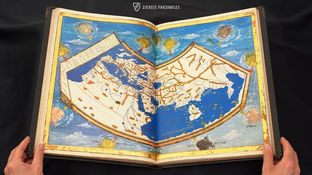
World Map
Framed by a thick strip of gold leaf, this extraordinary map of the world as it was known to 15th century Europeans is one of the finest of its kind both in terms of artistry and cartography. The West and Near East are depicted with remarkable accuracy and the curvature of the world is accounted for – medieval Europeans were more than aware that the world was not flat.
One of the most artful features of the map is the depiction of the 12 classical compass winds with their Latin names. Originating from ancient Greece, the 12-wind system is attributed to Aristotle and simpler versions predate Homer. They are typically named after the location from whence they seem to blow, or sometimes according to their character.
")
#1 Atlas de Claudio Ptolomeo
Language: Spanish, English
(3,000€ - 7,000€)
")

")
")
")
")

- Treatises / Secular Books
- Apocalypses / Beatus
- Astronomy / Astrology
- Bestiaries
- Bibles / Gospels
- Chronicles / History / Law
- Geography / Maps
- Saints' Lives
- Islam / Oriental
- Judaism / Hebrew
- Single Leaf Collections
- Leonardo da Vinci
- Literature / Poetry
- Liturgical Manuscripts
- Medicine / Botany / Alchemy
- Music
- Mythology / Prophecies
- Psalters
- Other Religious Books
- Games / Hunting
- Private Devotion Books
- Other Genres
- Afghanistan
- Armenia
- Austria
- Belgium
- Belize
- Bosnia and Herzegovina
- China
- Colombia
- Costa Rica
- Croatia
- Cyprus
- Czech Republic
- Denmark
- Egypt
- El Salvador
- Ethiopia
- France
- Germany
- Greece
- Guatemala
- Honduras
- Hungary
- India
- Iran
- Iraq
- Israel
- Italy
- Japan
- Jordan
- Kazakhstan
- Kyrgyzstan
- Lebanon
- Liechtenstein
- Luxembourg
- Mexico
- Morocco
- Netherlands
- Palestine
- Panama
- Peru
- Poland
- Portugal
- Romania
- Russia
- Serbia
- Spain
- Sri Lanka
- Sweden
- Switzerland
- Syria
- Tajikistan
- Turkey
- Turkmenistan
- Ukraine
- United Kingdom
- United States
- Uzbekistan
- Vatican City
- A. Oosthoek, van Holkema & Warendorf
- Aboca Museum
- Ajuntament de Valencia
- Akademie Verlag
- Akademische Druck- u. Verlagsanstalt (ADEVA)
- Aldo Ausilio Editore - Bottega d’Erasmo
- Alecto Historical Editions
- Alkuin Verlag
- Almqvist & Wiksell
- Amilcare Pizzi
- Andreas & Andreas Verlagsbuchhandlung
- Archa 90
- Archiv Verlag
- Archivi Edizioni
- Arnold Verlag
- ARS
- Ars Magna
- Ars Millenii
- Art Market
- ArtCodex
- AyN Ediciones
- Azimuth Editions
- Badenia Verlag
- Bärenreiter-Verlag
- Belser Verlag
- Belser Verlag / WK Wertkontor
- Benziger Verlag
- Bernardinum Wydawnictwo
- BiblioGemma
- Biblioteca Apostolica Vaticana (Vaticanstadt, Vaticanstadt)
- Bibliotheca Palatina Faksimile Verlag
- Bibliotheca Rara
- Boydell & Brewer
- Bramante Edizioni
- Bredius Genootschap
- Brepols Publishers
- British Library
- Brokarte
- C. Weckesser
- Caixa Catalunya
- Canesi
- CAPSA, Ars Scriptoria
- Caratzas Brothers, Publishers
- Carus Verlag
- Casamassima Libri
- Centrum Cartographie Verlag GmbH
- Chavane Verlag
- Christian Brandstätter Verlag
- Circulo Cientifico
- Club Bibliófilo Versol
- Club du Livre
- Club Internacional del Libro
- CM Editores
- Collegium Graphicum
- Collezione Apocrifa Da Vinci
- Comissão Nacional para as Comemorações dos Descobrimentos Portugueses
- Coron Verlag
- Corvina
- CTHS
- D. S. Brewer
- Damon
- De Agostini/UTET
- De Nederlandsche Boekhandel
- De Schutter
- Deuschle & Stemmle
- Deutscher Verlag für Kunstwissenschaft
- DIAMM
- Dropmore Press
- Droz
- E. Schreiber Graphische Kunstanstalten
- Ediciones Boreal
- Ediciones Grial
- Ediclube
- Edições Inapa
- Edilan
- Editalia
- Edition Deuschle
- Edition Georg Popp
- Edition Leipzig
- Edition Libri Illustri
- Editiones Reales Sitios S. L.
- Éditions de l'Oiseau Lyre
- Editions Medicina Rara
- Editorial Casariego
- Editorial Mintzoa
- Editrice Antenore
- Editrice Velar
- Edizioni Edison
- Egeria, S.L.
- Eikon Editores
- Electa
- Emery Walker Limited
- Enciclopèdia Catalana
- Eos-Verlag
- Ephesus Publishing
- Ernst Battenberg
- Eugrammia Press
- Extraordinary Editions
- Fackelverlag
- Facsimila Art & Edition
- Facsimile Editions Ltd.
- Facsimilia Art & Edition Ebert KG
- Faksimile Verlag
- Feuermann Verlag
- Folger Shakespeare Library
- Franco Cosimo Panini Editore
- Friedrich Wittig Verlag
- Fundación Hullera Vasco-Leonesa
- G. Braziller
- Gabriele Mazzotta Editore
- Gebr. Mann Verlag
- Gesellschaft für graphische Industrie
- Getty Research Institute
- Giovanni Domenico de Rossi
- Giunti Editore
- Goldenmark Librarium
- Graffiti
- Grafica European Center of Fine Arts
- Guido Pressler
- Guillermo Blazquez
- Gustav Kiepenheuer
- H. N. Abrams
- Harrassowitz
- Harvard University Press
- Helikon
- Hendrickson Publishers
- Henning Oppermann
- Herder Verlag
- Hes & De Graaf Publishers
- Hoepli
- Holbein-Verlag
- Houghton Library
- Hugo Schmidt Verlag
- Hungarian Academy of Sciences
- Idion Verlag
- Il Bulino, edizioni d'arte
- ILte
- Imago
- Insel Verlag
- Insel-Verlag Anton Kippenberger
- Instituto de Estudios Altoaragoneses
- Instituto Nacional de Antropología e Historia
- Introligatornia Budnik Jerzy
- Istituto dell'Enciclopedia Italiana - Treccani
- Istituto Ellenico di Studi Bizantini e Postbizantini
- Istituto Geografico De Agostini
- Istituto Poligrafico e Zecca dello Stato
- Italarte Art Establishments
- Jaca Book
- Jan Thorbecke Verlag
- Johnson Reprint Corporation
- Johnson Reprint Corporation
- Jos. Baer
- Josef Stocker
- Josef Stocker-Schmid
- Jugoslavija
- Karl W. Hiersemann
- Kasper Straube
- Kaydeda Ediciones
- Kindler Verlag / Coron Verlag
- Kodansha International Ltd.
- Konrad Kölbl Verlag
- Kurt Wolff Verlag
- La Liberia dello Stato
- La Linea Editrice
- La Meta Editore
- Lambert Schneider
- Landeskreditbank Baden-Württemberg
- Leo S. Olschki
- Les Incunables
- Liber Artis
- Library of Congress
- Libreria Musicale Italiana
- Lichtdruck
- Lito Immagine Editore
- Lumen Artis
- Lund Humphries
- M. Moleiro Editor
- Maison des Sciences de l'homme et de la société de Poitiers
- Manuscriptum
- Martinus Nijhoff
- Maruzen-Yushodo Co. Ltd.
- MASA
- Massada Publishers
- McGraw-Hill
- Metropolitan Museum of Art
- Militos
- Millennium Liber
- Müller & Schindler
- Nahar - Stavit
- Nahar and Steimatzky
- National Library of Wales
- Neri Pozza
- Nova Charta
- Oceanum Verlag
- Odeon
- Omnia Arte
- Orbis Mediaevalis
- Orbis Pictus
- Österreichische Staatsdruckerei
- Oxford University Press
- Pageant Books
- Parzellers Buchverlag
- Patrimonio Ediciones
- Pattloch Verlag
- PIAF
- Pieper Verlag
- Plon-Nourrit et cie
- Poligrafiche Bolis
- Presses Universitaires de Strasbourg
- Prestel Verlag
- Princeton University Press
- Prisma Verlag
- Priuli & Verlucca, editori
- Pro Sport Verlag
- Propyläen Verlag
- Pytheas Books
- Quaternio Verlag Luzern
- Reales Sitios
- Recht-Verlag
- Reichert Verlag
- Reichsdruckerei
- Reprint Verlag
- Riehn & Reusch
- Roberto Vattori Editore
- Rosenkilde and Bagger
- Roxburghe Club
- Salerno Editrice
- Saltellus Press
- Sandoz
- Sarajevo Svjetlost
- Schöck ArtPrint Kft.
- Schulsinger Brothers
- Scolar Press
- Scrinium
- Scripta Maneant
- Scriptorium
- Shazar
- Siloé, arte y bibliofilia
- SISMEL - Edizioni del Galluzzo
- Sociedad Mexicana de Antropología
- Société des Bibliophiles & Iconophiles de Belgique
- Soncin Publishing
- Sorli Ediciones
- Stainer and Bell
- Studer
- Styria Verlag
- Sumptibus Pragopress
- Szegedi Tudomànyegyetem
- Taberna Libraria
- Tarshish Books
- Taschen
- Tempus Libri
- Testimonio Compañía Editorial
- TGB Limited Editions
- Thames and Hudson
- The Clear Vue Publishing Partnership Limited
- The Facsimile Codex
- The Folio Society
- The Marquess of Normanby
- The Orphan Hospital Ward of Israel
- The Richard III and Yorkist History Trust
- The Warburg Institute
- Tip.Le.Co
- TouchArt
- TREC Publishing House
- TRI Publishing Co.
- Trident Editore
- Tuliba Collection
- Typis Regiae Officinae Polygraphicae
- Union Verlag Berlin
- Universidad de Granada
- Universitaire Bibliotheken Leiden
- University of California Press
- University of Chicago Press
- Urs Graf
- Vallecchi
- Van Wijnen
- VCH, Acta Humaniora
- VDI Verlag
- VEB Deutscher Verlag für Musik
- Verein Schweizerischer Lithographie-Besitzer
- Verlag Anton Pustet / Andreas Verlag
- Verlag Bibliophile Drucke Josef Stocker
- Verlag der Münchner Drucke
- Verlag für Regionalgeschichte
- Verlag Styria
- Vicent Garcia Editores
- W. Turnowsky
- Waanders Printers
- Wiener Mechitharisten-Congregation (Wien, Österreich)
- Wissenschaftliche Buchgesellschaft
- Wissenschaftliche Verlagsgesellschaft
- Wydawnictwo Dolnoslaskie
- Xuntanza Editorial
- Zakład Narodowy
- Zollikofer AG