
Claudius Ptolemy: Cosmographia
Florence (Italy) — 1460–1466
The revival of the ancient world view in the Renaissance: Mathematical precision, brilliant maps, and the splendor of courtly book art masterfully united by Nicolaus Germanus
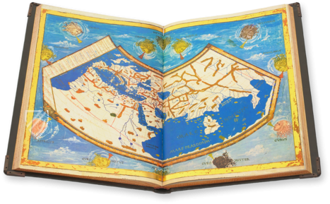
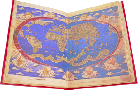
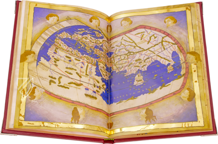
Impressive planisphere of the known world with personified winds
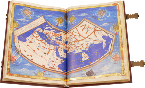
Brilliantly colored maps in gilded frames based on mathematical coordinates
Presumably illuminated by a Florentine artist inspired by the style of Francesco Antonio del Chierico
Claudius Ptolemy: Cosmographia

(under 1,000€)
Created in the second half of the fifteenth century, the Cosmographia of Claudius Ptolemy ranks among the most precious cartographic manuscripts of the Renaissance. In this work, the Benedictine monk and cartographer Nicolaus Germanus transformed the geographical knowledge of antiquity into a magnificent new book form. It is based on the Latin translation by Jacopo Angelo da Scarperia, which made Ptolemy’s long-neglected teachings accessible once again in the West. Brilliantly colored maps framed in gold depict countries, seas, mountains, and cities according to mathematically determined coordinates. The highlight is an impressive planisphere of the world as it was then known, surrounded by personifications of the winds. The combination of ancient scholarship, innovative cartography, and Florentine illumination makes the manuscript an exceptional witness to an age in which Europe began to measure the world anew.
The Rediscovery of an Ancient World View
In the second century, Claudius Ptolemy created a systematic description of the known world with his Geographia. In eight books, he combined lists of places with longitude and latitude and explained how the curved surface of the Earth could be represented on a flat map. This mathematically ordered image of the world was later largely forgotten in Western Europe.
At the beginning of the fifteenth century, the work was rediscovered in Italy. The humanist Jacopo Angelo da Scarperia translated the Greek text into Latin and gave it the title Cosmographia. Ptolemy’s geographical treatise thus became a key work of Renaissance humanism.
Nicolaus Germanus and the Renewal of Cartography
Between around 1460 and 1466, the Benedictine monk Nicolaus Germanus created this magnificent manuscript. He was far more than a copyist: Germanus revised the cartographic presentation, reorganized the numerical data, and developed an improved conical projection in which the meridians converge towards the pole.
His adaptations also shaped the earliest printed editions of Ptolemy’s geography. The maps therefore connect the manuscript culture of learning with the cartographic innovations of the Renaissance.
The Earth Measured and Ordered
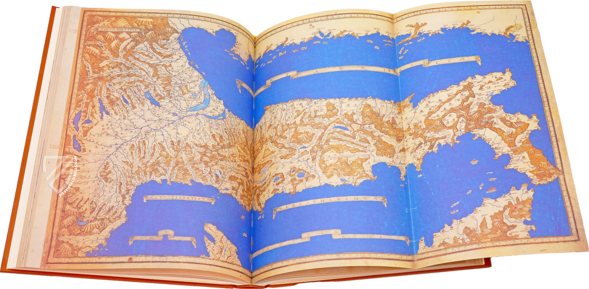
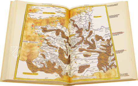
Ptolemy’s method was based on the idea that every place could be defined by geographical coordinates. The maps are enclosed by frames marked with degrees of longitude and latitude. Countries, seas, mountains, and forests thus become parts of a measurable geographical system.
At the same time, the representations reveal the limits of ancient knowledge. Europe, North Africa, and large parts of Asia are recorded in considerable detail, while other regions appear compressed or distorted. This very contrast makes the manuscript a fascinating record of the world before the great voyages of discovery.
An Atlas of Courtly Splendor
The maps glow in shades of blue, green, white, and brown and are surrounded by gilded frames. Waters, mountain ranges, and landscapes are distinguished by color, while place names and coordinates make the scientific organization clearly visible. In this way, cartographic precision is united with precious book art.
The painted decoration has been attributed to a Florentine artist, possibly from the circle of Francesco di Antonio del Chierico. The generous format and finely balanced palette show that the manuscript was intended not only for study, but also as a prestigious showpiece for a princely court.
The World Map and the Winds
The visual climax is the great planisphere at the center of the codex. It brings the known world together in a single image and is surrounded by personifications of the winds. Against a delicately painted blue background, the wind heads appear to encircle the Earth, evoking the forces that governed climate, direction, and navigation.
The combination of scientific world model and classical pictorial tradition gives the map its distinctive power. The Earth appears both as a measurable space and as part of a greater cosmic order.
A Key Work of Renaissance Cartography
The Cosmographia of Claudius Ptolemy stands at the threshold between inherited knowledge and a new experience of the world. It still presents the Earth according to the ideas of an ancient scholar, yet Nicolaus Germanus’s revisions anticipated the cartographic forms that would influence the earliest printed atlases.
Its exceptional importance lies in the unity of ancient scholarship, humanist renewal, and artistic perfection. As a magnificent re-creation of a text nearly 1,300 years old, it embodies the Renaissance desire to recover the knowledge of antiquity and give it an entirely new visual form.
Codicology
- Alternative Titles
- Claudius Ptolemäus: Cosmographia
Claudius Ptolemäus. Cosmographia. Weltkarten. - Size / Format
- 248 pages / 44.0 × 29.0 cm
- Origin
- Italy
- Date
- 1460–1466
- Epochs
- Style
- Language
- Illustrations
- 27 double-page maps
- Artist / School
- Claudius Ptolemy (author)
Donnus Nicolaus Germanus (cartographer) - Previous Owners
- Farnese family
#1 Claudius Ptolemäus. Cosmographia. Weltkarten.
Language: German
(under 1,000€)
- Block Books / Incunables / Post-incunables
- Alchemy
- Apocalypses / Beatus Manuscripts
- Astronomy / Astrology
- Bibles / Gospels
- Picture Bibles / Bibles Moralisées / Mirror of Human Salvation
- Botany
- Chronicles / History / Letters
- Cookbook / Recipes
- Diaries / Biographies / Autograph Books
- Encyclopedias
- Fashion / Costume Books
- Games / Game Theory
- Geography / Cartography / Navigation
- Graduals / Antiphonaries / Exultet Roll
- Haggadot
- Hunting Books
- Law / Deeds / Rules
- Leonardo da Vinci
- Literature / Poetry
- Medicine
- Missals / Lectionaries / Sacramentaries
- Model Books / Sketchbooks / Notebooks
- Music
- Mythology
- Natural History / Bestiaries
- Other Liturgical Manuscripts
- Other Religious Works
- Other Secular Works
- Paintings / Graphics
- Primers / Textbooks
- Private Devotion Books
- Prophecies / Divination
- Psalters
- Quran
- Saints' Lives
- Sermons / Homilies
- Single Leaf Collections
- Song Books
- Tanakh
- Tournament Books / Armorials / Genealogy
- Travelogues / Travel Guides
- Treatises
- Afghanistan
- Algeria
- Armenia
- Austria
- Azerbaijan
- Belarus
- Belgium
- Belize
- Bosnia and Herzegovina
- China
- Colombia
- Costa Rica
- Croatia
- Cyprus
- Czech Republic
- Denmark
- Egypt
- El Salvador
- Ethiopia
- France
- Germany
- Greece
- Guatemala
- Honduras
- Hungary
- India
- Iran
- Iraq
- Israel
- Italy
- Japan
- Jordan
- Kazakhstan
- Kyrgyzstan
- Lebanon
- Libya
- Liechtenstein
- Luxembourg
- Mexico
- Morocco
- Netherlands
- Palestine
- Panama
- Peru
- Poland
- Portugal
- Romania
- Russia
- Serbia
- Slovakia
- Spain
- Sri Lanka
- Sweden
- Switzerland
- Syria
- Tajikistan
- Tunisia
- Turkey
- Turkmenistan
- Ukraine
- United Kingdom
- United States
- Uzbekistan
- Vatican City
- A. Oosthoek, van Holkema & Warendorf
- Aboca Museum
- Ajuntament de Valencia
- Akademie Verlag
- Akademische Druck- u. Verlagsanstalt (ADEVA)
- Aldo Ausilio Editore - Bottega d’Erasmo
- Alecto Historical Editions
- Alkuin Verlag
- Almqvist & Wiksell
- Amilcare Pizzi
- Andreas & Andreas Verlagsbuchhandlung
- Archa 90
- Archiv Verlag
- Archivi Edizioni
- Arnold Verlag
- ARS
- Ars Magna
- Ars Millenii
- Art Market
- ArtCodex
- AyN Ediciones
- Azimuth Editions
- Badenia Verlag
- Bärenreiter-Verlag
- Belser Verlag
- Belser Verlag / WK Wertkontor
- Benziger Verlag
- Bernardinum Wydawnictwo
- BiblioGemma
- Biblioteca Apostolica Vaticana (Vaticanstadt, Vaticanstadt)
- Bibliotheca Palatina Faksimile Verlag
- Bibliotheca Rara
- Boydell & Brewer
- Bramante Edizioni
- Bredius Genootschap
- Brepols Publishers
- British Library
- Brokarte
- C. Weckesser
- Caixa Catalunya
- Canesi
- CAPSA, Ars Scriptoria
- Caratzas Brothers, Publishers
- Carus Verlag
- Casamassima Libri
- Centrum Cartographie Verlag GmbH
- Chavane Verlag
- Christian Brandstätter Verlag
- Circulo Cientifico
- Club Bibliófilo Versol
- Club du Livre
- Club Internacional del Libro
- CM Editores
- Collegium Graphicum
- Collezione Apocrifa Da Vinci
- Comissão Nacional para as Comemorações dos Descobrimentos Portugueses
- Coron Verlag
- Corvina
- CTHS
- D. S. Brewer
- Damon
- De Agostini/UTET
- De Nederlandsche Boekhandel
- De Schutter
- Deuschle & Stemmle
- Deutscher Verlag für Kunstwissenschaft
- DIAMM
- Dropmore Press
- Droz
- E. Schreiber Graphische Kunstanstalten
- Ediciones Boreal
- Ediciones Grial
- Ediclube
- Edições Inapa
- Edilan
- Editalia
- Edition Deuschle
- Edition Georg Popp
- Edition Leipzig
- Edition Libri Illustri
- Editiones Reales Sitios S. L.
- Éditions de l'Oiseau Lyre
- Editions Medicina Rara
- Editorial Base
- Editorial Casariego
- Editorial Mintzoa
- Editrice Antenore
- Editrice Velar
- Edizioni Edison
- Egeria, S.L.
- Eikon Editores
- Electa
- Emery Walker Limited
- Enciclopèdia Catalana
- Eos-Verlag
- Ephesus Publishing
- Ernst Battenberg
- Eugrammia Press
- Extraordinary Editions
- Fackelverlag
- Facsimila Art & Edition
- Facsimile Editions Ltd.
- Facsimilia Art & Edition Ebert KG
- Faksimile Verlag
- Feuermann Verlag
- Folger Shakespeare Library
- Franco Cosimo Panini Editore
- Friedrich Wittig Verlag
- Fundación Hullera Vasco-Leonesa
- G. Braziller
- Gabriele Mazzotta Editore
- Gebr. Mann Verlag
- Gesellschaft für graphische Industrie
- Getty Research Institute
- Giovanni Domenico de Rossi
- Giunti Editore
- Goldenmark Librarium
- Graffiti
- Grafica European Center of Fine Arts
- Guido Pressler
- Guillermo Blazquez
- Gustav Kiepenheuer
- H. N. Abrams
- Harrassowitz
- Harvard University Press
- Helikon
- Hendrickson Publishers
- Henning Oppermann
- Herder Verlag
- Hes & De Graaf Publishers
- Hoepli
- Holbein-Verlag
- Houghton Library
- Hugo Schmidt Verlag
- Hungarian Academy of Sciences
- Idion Verlag
- Il Bulino, edizioni d'arte
- ILte
- Imago
- In Officina Danesi
- Insel Verlag
- Instituto de Estudios Altoaragoneses
- Instituto Nacional de Antropología e Historia
- Introligatornia Budnik Jerzy
- Istituto dell'Enciclopedia Italiana - Treccani
- Istituto Ellenico di Studi Bizantini e Postbizantini
- Istituto Geografico De Agostini
- Istituto Poligrafico e Zecca dello Stato
- Italarte Art Establishments
- Jaca Book
- Jan Thorbecke Verlag
- Johnson Reprint Corporation
- Johnson Reprint Corporation
- Jos. Baer
- Josef Stocker
- Josef Stocker-Schmid
- Jugoslavija
- Karl W. Hiersemann
- Kasper Straube
- Kaydeda Ediciones
- Kindler Verlag / Coron Verlag
- Kodansha International Ltd.
- Konrad Kölbl Verlag
- Kurt Wolff Verlag
- La Linea Editrice
- La Meta Editore
- Lambert Schneider
- Landeskreditbank Baden-Württemberg
- Leo S. Olschki
- Les Incunables
- Liber Artis
- Library of Congress
- Libreria Musicale Italiana
- Lichtdruck
- Lito Immagine Editore
- Lumen Artis
- Lund Humphries
- M. Moleiro Editor
- Maison des Sciences de l'homme et de la société de Poitiers
- Manuscriptum
- Martinus Nijhoff
- Maruzen-Yushodo Co. Ltd.
- MASA
- Massada Publishers
- McGraw-Hill
- Metropolitan Museum of Art
- Militos
- Millennium Liber
- Müller & Schindler
- Nahar - Stavit
- Nahar and Steimatzky
- National Library of Wales
- Neri Pozza
- Nova Charta
- Oceanum Verlag
- Odeon
- Omnia Arte
- Orbis Mediaevalis
- Orbis Pictus
- Österreichische Staatsdruckerei
- Oxford University Press
- Pageant Books
- Parzellers Buchverlag
- Patrimonio Ediciones
- Pattloch Verlag
- PIAF
- Plon-Nourrit et cie
- Poligrafiche Bolis
- Presses Universitaires de Strasbourg
- Prestel Verlag
- Princeton University Press
- Prisma Verlag
- Priuli & Verlucca, editori
- Pro Sport Verlag
- Propyläen Verlag
- Pytheas Books
- Quaternio Verlag Luzern
- Reales Sitios
- Recht-Verlag
- Reichert Verlag
- Reichsdruckerei
- Reprint Verlag
- Riehn & Reusch
- Rizzoli
- Roberto Vattori Editore
- Rosenkilde and Bagger
- Roto-Sadag
- Roxburghe Club
- Salerno Editrice
- Saltellus Press
- Sandoz
- Sarajevo Svjetlost
- Schöck ArtPrint Kft.
- Schulsinger Brothers
- Scolar Press
- Scrinium
- Scripta Maneant
- Scriptorium
- Shazar
- Siloé, arte y bibliofilia
- SISMEL - Edizioni del Galluzzo
- Sociedad Mexicana de Antropología
- Société des Bibliophiles & Iconophiles de Belgique
- Soncin Publishing
- Sorli Ediciones
- Stainer and Bell
- Studer
- Styria Verlag
- Sumptibus Pragopress
- Szegedi Tudomànyegyetem
- Taberna Libraria
- Tarshish Books
- Taschen
- Tempus Libri
- Testimonio Compañía Editorial
- TGB Limited Editions
- Thames and Hudson
- The Clear Vue Publishing Partnership Limited
- The Facsimile Codex
- The Folio Society
- The Marquess of Normanby
- The Orphan Hospital Ward of Israel
- The Richard III and Yorkist History Trust
- The Warburg Institute
- Tip.Le.Co
- TouchArt
- TREC Publishing House
- TRI Publishing Co.
- Trident Editore
- Tuliba Collection
- Typis Regiae Officinae Polygraphicae
- Union Verlag Berlin
- Universidad de Granada
- Universitaire Bibliotheken Leiden
- University of California Press
- University of Chicago Press
- Urs Graf
- Vallecchi
- Van Wijnen
- VCH, Acta Humaniora
- VDI Verlag
- VEB Deutscher Verlag für Musik
- Verein Schweizerischer Lithographie-Besitzer
- Verlag Anton Pustet / Andreas Verlag
- Verlag Bibliophile Drucke Josef Stocker
- Verlag der Münchner Drucke
- Verlag für Regionalgeschichte
- Verlag Styria
- Vicent Garcia Editores
- W. Turnowsky
- Waanders Printers
- Wiener Mechitharisten-Congregation (Wien, Österreich)
- Wissenschaftliche Buchgesellschaft
- Wissenschaftliche Verlagsgesellschaft
- Wydawnictwo Dolnoslaskie
- Xuntanza Editorial
- Zakład Narodowy
- Zollikofer AG