Atlas Harmonia Macrocosmica by Andreas Cellarius
")
Germany — 1661
A fascinating 17th century look at the stars and ancient mythology: the world systems of Ptolemy, Copernicus, and Tycho Brahe compiled in beautiful copperplate engravings
This star atlas was written by Andreas Cellarius (ca. 1596–1665) and published in 1660 by Johannes Janssonius (1588–1664)
It contains copperplates depicting the world systems of Ptolemy, Copernicus, and Tycho Brahe
Star maps of the classical and Christian constellations round out the gorgeous 17th century work
Atlas Harmonia Macrocosmica by Andreas Cellarius

")
")
")
")
")
")
")
")
")
")
")
")
")
")
")
")
")
")
")
")
(under 1,000€)
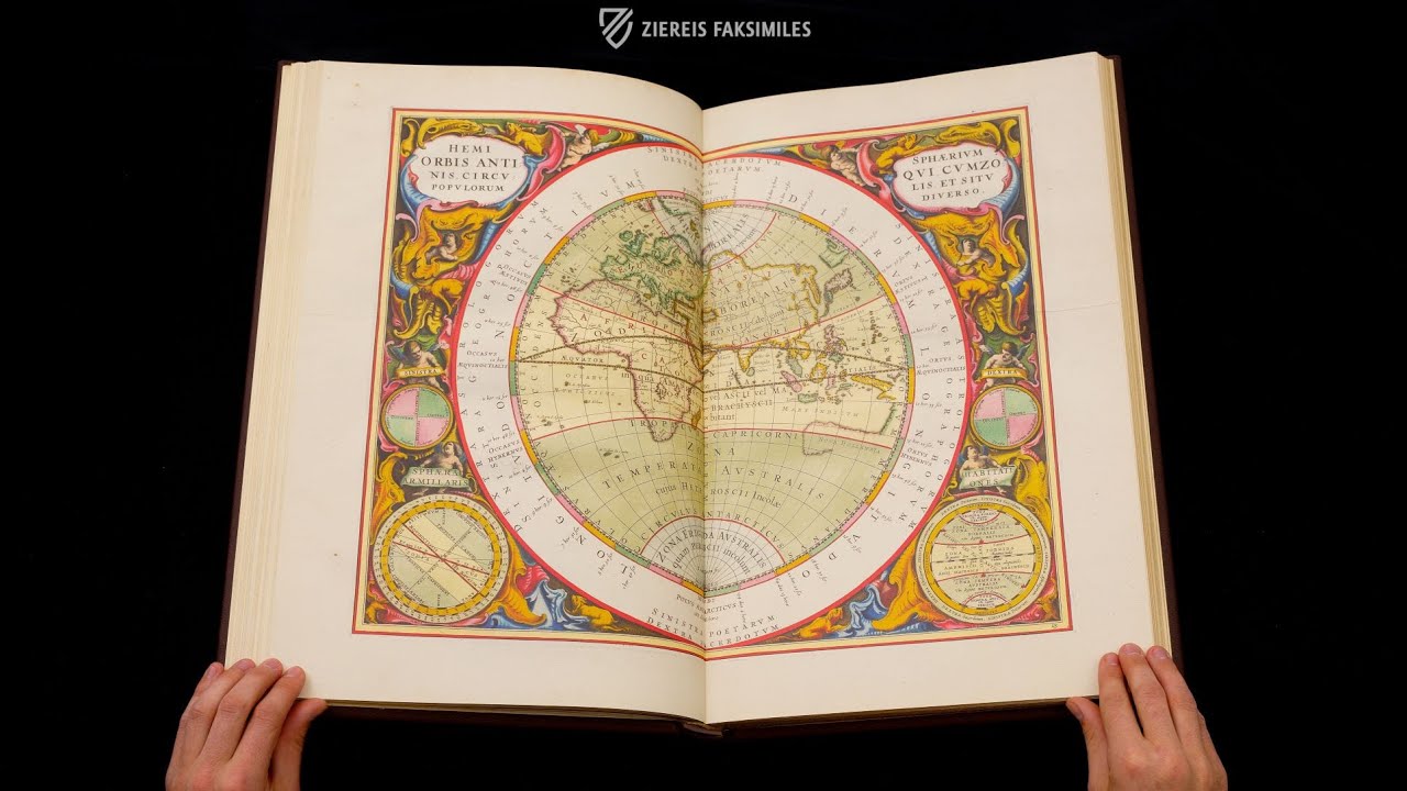
Published in 1661, the Atlas Harmonia Macrocosmia by astronomer, mathematician, and cartographer Andreas Cellarius (c. 1596–1665) is a comprehensive celestial atlas featuring particularly magnificent copperplate engravings. A total of 21 beautifully colored and incredibly detailed double-page maps show the world according to the models of Claudius Ptolemy (c. 100 – after 160 AD), Nicolaus Copernicus (1473–1543), and Tycho Brahe (1546–1601). Eight further engravings show the constellations according to Christian and classical interpretations. Together, they impressively illustrate to the beholder the development of the astronomical perspective on the world and are a wonderful testimony to the Baroque art of printing. For the first time, the Dutchman Johannes Janssonius (1588–1664) published the historical star atlas in 1660 in his Amsterdam publishing house, which was well known for astronomical and geographical works.
Atlas Harmonia Macrocosmica by Andreas Cellarius
The Atlas Harmonia Macrocosmia by Andreas Cellarius (ca. 1596–1665) is one of the most magnificently colored astronomical works of the Baroque period. The historical star atlas from 1661 shows the world according to models by Claudius Ptolemy, Nicolaus Copernicus, and Tycho Brahe on a total of 21 engravings. Eight further double-paged colored engravings are dedicated to star constellations with classical and Christian interpretations. With his first-class plates by Frederik Hendrik van den Hooven (ca. 1628–1698), Jan van Loon, and Jan Pieterszoon Saenredan (1565–1607), the celestial atlas impressively presents the observer with the development of the astronomical world view.
A German Astronomer in the Netherlands
The astronomer, mathematician, and cartographer Andreas Cellarius came from the area of Worms. However, he had lived and worked as a teacher in the Netherlands, where the manufacture of globes and precise maps had a long tradition, since 1625. The Atlas Harmonia Macrocosmia, his only astronomical work, was first published by Johannes Janssonius (1588–1664) in 1660. The Dutchman's publishing house in Amsterdam was well-known for astronomy and cartography, so Janssonius printed the work as a supplement to his Altlas Novus.
Popular Copperplate Charts
Few other astronomical works possess depictions that are as well-known as those from Cellarius' celestial atlas. Again and again, they were reproduced for books, posters, and even puzzles and enjoyed great popularity. They amaze their viewers with plentiful details again and again. Above all, the elaborate frame illustrations delight with numerous small angels, various astronomers, and also interesting astronomical instruments.
The 29 double-page, colored copperplate engravings in detail
- The Ptolemaic Planisphere, that is, the machinery of the celestial circles according to Ptolemy's hypothesis in a planar depiction
- The scenario of the Ptolemaic world system (presentation page)
- The scenario of the planetary circles enclosing the Earth
- The Copernican Planisphere, that is, the system of the entire creation of the world according to Copernicus's hypothesis, presented in a planar depiction
- The scenario of the Copernican system
- The Brahean Planisphere, that is, the structure of the entire world according to Tycho Brahe's hypothesis, depicted in a planar depiction
- The scenario of the world structure according to Tycho Brahe
- The Planisphere of Aratos, that is, the structure of the celestial circles according to Aratos's hypothesis in a planar depiction
- Tycho Brahe's calculation of the planets' movements and their distances
- The size of the celestial bodies
- The position of the Earth surrounded by the celestial circles
- The hemispheres, demonstrating the influence on motion and length for both terrestrial and celestial spheres, both straight and oblique, and also for the stars
- The hemisphere of the ancient world with its zones and circles, as well as the areas of its various inhabitants
- The traditional Ptolemaic hypothesis, as it represents the motion of the planets with eccentrics and epicycles
- The image of the aspects of the planets, oppositions, conjunctions, etc.
- The theory of solar motion with an eccentric circle without an epicycle
- The spiral motion of the Sun around the Earth
- The theory of the Moon, representing its motion on an eccentric circle and an epicycle
- The image of the Moon, outlining the various phases and aspects of the Moon
- The theory of the motion of the three upper planets
- The theory of the motion of Venus and Mercury
- The first hemisphere of the Christian celestial heaven
- The second hemisphere of the Christian celestial heaven
- The northern hemisphere according to the traditional conception
- The scenery of the northern hemisphere, heaven and Earth
- The northern hemisphere with the Earth's hemisphere superimposed on it
- The southern hemisphere according to the traditional conception
- The scenery of the southern hemisphere, heaven and Earth
- The southern hemisphere in equal proportion with the Earth's spheres
Codicology
- Alternative Titles
- Atlas Harmonia Macrocosmica von Andreas Cellarius
Cellarius Himmelsatlas
Cellarius Himmelsatlas - Atlas Harmonia Macrocosmica
Die Harmonie der grossen Welt - Size / Format
- 134 pages / 52.0 × 33.0 cm
- Origin
- Germany
- Date
- 1661
- Epochs
- Style
- Language
- Illustrations
- 29 double-page colourized copperplate maps
frontispiece - Content
- Star atlas with copper plate depicting the world systems of Claudius Ptolemy, Nicolaus Copernicus and Tycho Brahe and showing classical and Christian constellations.
- Artist / School
- Andreas Cellarius (1596–1665)
Johannes Janssonius (publisher)
Jan van Loon (engraver)
Frederik Hendrik van den Hooven (illustrator)
")
Atlas Harmonia Macrocosmica by Andreas Cellarius
2000 Years of Astronomical Research
On the title page, this community of scholars welcomes readers and represents 2,000 years of astronomical research. Some of them are rendered with portrait-like features. They are all gathered around the muse Urania, the mythical protector of the mathematical arts. The scholars depicted are, from left to right: Tycho Brahe, Claudius Ptolemy, Albategnius, King Alfonso X the Wise, Galileo Galilei and Nicolaus Copernicus.
")
Atlas Harmonia Macrocosmica by Andreas Cellarius
The World System According to Copernicus
At the center of the system shines a wise and dignified-looking sun, whose light illuminates the entire system. The planets Mercury, Venus, Mars, Jupiter and Saturn, depicted as star-like objects, trace their orbits around it. Earth, or rather the northern hemisphere, is shown four times, representing the four seasons. The outer ring consists of constellations arranged and named according to their seasonal visibility.
The astrological depiction is flanked at the bottom by two personifications: Justice and Scholarship. Holding a scepter, Justice sits blindfolded before a globe, seemingly judging the various astronomical world systems. The golden clock may suggest that increasingly precise celestial observations were possible with the help of precision clocks in the 80 years prior to the creation of the atlas.
")
#1 Atlas Harmonia Macrocosmica von Andreas Cellarius
Language: German
(under 1,000€)
")
")
")
")
")
")
- Treatises / Secular Books
- Apocalypses / Beatus
- Astronomy / Astrology
- Bestiaries
- Bibles / Gospels
- Chronicles / History / Law
- Geography / Maps
- Saints' Lives
- Islam / Oriental
- Judaism / Hebrew
- Single Leaf Collections
- Leonardo da Vinci
- Literature / Poetry
- Liturgical Manuscripts
- Medicine / Botany / Alchemy
- Music
- Mythology / Prophecies
- Psalters
- Other Religious Books
- Games / Hunting
- Private Devotion Books
- Other Genres
- Afghanistan
- Armenia
- Austria
- Belgium
- Belize
- Bosnia and Herzegovina
- China
- Colombia
- Costa Rica
- Croatia
- Cyprus
- Czech Republic
- Denmark
- Egypt
- El Salvador
- Ethiopia
- France
- Germany
- Greece
- Guatemala
- Honduras
- Hungary
- India
- Iran
- Iraq
- Israel
- Italy
- Japan
- Jordan
- Kazakhstan
- Kyrgyzstan
- Lebanon
- Liechtenstein
- Luxembourg
- Mexico
- Morocco
- Netherlands
- Palestine
- Panama
- Peru
- Poland
- Portugal
- Romania
- Russia
- Serbia
- Spain
- Sri Lanka
- Sweden
- Switzerland
- Syria
- Tajikistan
- Turkey
- Turkmenistan
- Ukraine
- United Kingdom
- United States
- Uzbekistan
- Vatican City
- A. Oosthoek, van Holkema & Warendorf
- Aboca Museum
- Ajuntament de Valencia
- Akademie Verlag
- Akademische Druck- u. Verlagsanstalt (ADEVA)
- Aldo Ausilio Editore - Bottega d’Erasmo
- Alecto Historical Editions
- Alkuin Verlag
- Almqvist & Wiksell
- Amilcare Pizzi
- Andreas & Andreas Verlagsbuchhandlung
- Archa 90
- Archiv Verlag
- Archivi Edizioni
- Arnold Verlag
- ARS
- Ars Magna
- Ars Millenii
- Art Market
- ArtCodex
- AyN Ediciones
- Azimuth Editions
- Badenia Verlag
- Bärenreiter-Verlag
- Belser Verlag
- Belser Verlag / WK Wertkontor
- Benziger Verlag
- Bernardinum Wydawnictwo
- BiblioGemma
- Biblioteca Apostolica Vaticana (Vaticanstadt, Vaticanstadt)
- Bibliotheca Palatina Faksimile Verlag
- Bibliotheca Rara
- Boydell & Brewer
- Bramante Edizioni
- Bredius Genootschap
- Brepols Publishers
- British Library
- Brokarte
- C. Weckesser
- Caixa Catalunya
- Canesi
- CAPSA, Ars Scriptoria
- Caratzas Brothers, Publishers
- Carus Verlag
- Casamassima Libri
- Centrum Cartographie Verlag GmbH
- Chavane Verlag
- Christian Brandstätter Verlag
- Circulo Cientifico
- Club Bibliófilo Versol
- Club du Livre
- Club Internacional del Libro
- CM Editores
- Collegium Graphicum
- Collezione Apocrifa Da Vinci
- Comissão Nacional para as Comemorações dos Descobrimentos Portugueses
- Coron Verlag
- Corvina
- CTHS
- D. S. Brewer
- Damon
- De Agostini/UTET
- De Nederlandsche Boekhandel
- De Schutter
- Deuschle & Stemmle
- Deutscher Verlag für Kunstwissenschaft
- DIAMM
- Dropmore Press
- Droz
- E. Schreiber Graphische Kunstanstalten
- Ediciones Boreal
- Ediciones Grial
- Ediclube
- Edições Inapa
- Edilan
- Editalia
- Edition Deuschle
- Edition Georg Popp
- Edition Leipzig
- Edition Libri Illustri
- Editiones Reales Sitios S. L.
- Éditions de l'Oiseau Lyre
- Editions Medicina Rara
- Editorial Casariego
- Editorial Mintzoa
- Editrice Antenore
- Editrice Velar
- Edizioni Edison
- Egeria, S.L.
- Eikon Editores
- Electa
- Emery Walker Limited
- Enciclopèdia Catalana
- Eos-Verlag
- Ephesus Publishing
- Ernst Battenberg
- Eugrammia Press
- Extraordinary Editions
- Fackelverlag
- Facsimila Art & Edition
- Facsimile Editions Ltd.
- Facsimilia Art & Edition Ebert KG
- Faksimile Verlag
- Feuermann Verlag
- Folger Shakespeare Library
- Franco Cosimo Panini Editore
- Friedrich Wittig Verlag
- Fundación Hullera Vasco-Leonesa
- G. Braziller
- Gabriele Mazzotta Editore
- Gebr. Mann Verlag
- Gesellschaft für graphische Industrie
- Getty Research Institute
- Giovanni Domenico de Rossi
- Giunti Editore
- Goldenmark Librarium
- Graffiti
- Grafica European Center of Fine Arts
- Guido Pressler
- Guillermo Blazquez
- Gustav Kiepenheuer
- H. N. Abrams
- Harrassowitz
- Harvard University Press
- Helikon
- Hendrickson Publishers
- Henning Oppermann
- Herder Verlag
- Hes & De Graaf Publishers
- Hoepli
- Holbein-Verlag
- Houghton Library
- Hugo Schmidt Verlag
- Hungarian Academy of Sciences
- Idion Verlag
- Il Bulino, edizioni d'arte
- ILte
- Imago
- Insel Verlag
- Insel-Verlag Anton Kippenberger
- Instituto de Estudios Altoaragoneses
- Instituto Nacional de Antropología e Historia
- Introligatornia Budnik Jerzy
- Istituto dell'Enciclopedia Italiana - Treccani
- Istituto Ellenico di Studi Bizantini e Postbizantini
- Istituto Geografico De Agostini
- Istituto Poligrafico e Zecca dello Stato
- Italarte Art Establishments
- Jaca Book
- Jan Thorbecke Verlag
- Johnson Reprint Corporation
- Johnson Reprint Corporation
- Jos. Baer
- Josef Stocker
- Josef Stocker-Schmid
- Jugoslavija
- Karl W. Hiersemann
- Kasper Straube
- Kaydeda Ediciones
- Kindler Verlag / Coron Verlag
- Kodansha International Ltd.
- Konrad Kölbl Verlag
- Kurt Wolff Verlag
- La Liberia dello Stato
- La Linea Editrice
- La Meta Editore
- Lambert Schneider
- Landeskreditbank Baden-Württemberg
- Leo S. Olschki
- Les Incunables
- Liber Artis
- Library of Congress
- Libreria Musicale Italiana
- Lichtdruck
- Lito Immagine Editore
- Lumen Artis
- Lund Humphries
- M. Moleiro Editor
- Maison des Sciences de l'homme et de la société de Poitiers
- Manuscriptum
- Martinus Nijhoff
- Maruzen-Yushodo Co. Ltd.
- MASA
- Massada Publishers
- McGraw-Hill
- Metropolitan Museum of Art
- Militos
- Millennium Liber
- Müller & Schindler
- Nahar - Stavit
- Nahar and Steimatzky
- National Library of Wales
- Neri Pozza
- Nova Charta
- Oceanum Verlag
- Odeon
- Omnia Arte
- Orbis Mediaevalis
- Orbis Pictus
- Österreichische Staatsdruckerei
- Oxford University Press
- Pageant Books
- Parzellers Buchverlag
- Patrimonio Ediciones
- Pattloch Verlag
- PIAF
- Pieper Verlag
- Plon-Nourrit et cie
- Poligrafiche Bolis
- Presses Universitaires de Strasbourg
- Prestel Verlag
- Princeton University Press
- Prisma Verlag
- Priuli & Verlucca, editori
- Pro Sport Verlag
- Propyläen Verlag
- Pytheas Books
- Quaternio Verlag Luzern
- Reales Sitios
- Recht-Verlag
- Reichert Verlag
- Reichsdruckerei
- Reprint Verlag
- Riehn & Reusch
- Roberto Vattori Editore
- Rosenkilde and Bagger
- Roxburghe Club
- Salerno Editrice
- Saltellus Press
- Sandoz
- Sarajevo Svjetlost
- Schöck ArtPrint Kft.
- Schulsinger Brothers
- Scolar Press
- Scrinium
- Scripta Maneant
- Scriptorium
- Shazar
- Siloé, arte y bibliofilia
- SISMEL - Edizioni del Galluzzo
- Sociedad Mexicana de Antropología
- Société des Bibliophiles & Iconophiles de Belgique
- Soncin Publishing
- Sorli Ediciones
- Stainer and Bell
- Studer
- Styria Verlag
- Sumptibus Pragopress
- Szegedi Tudomànyegyetem
- Taberna Libraria
- Tarshish Books
- Taschen
- Tempus Libri
- Testimonio Compañía Editorial
- TGB Limited Editions
- Thames and Hudson
- The Clear Vue Publishing Partnership Limited
- The Facsimile Codex
- The Folio Society
- The Marquess of Normanby
- The Orphan Hospital Ward of Israel
- The Richard III and Yorkist History Trust
- The Warburg Institute
- Tip.Le.Co
- TouchArt
- TREC Publishing House
- TRI Publishing Co.
- Trident Editore
- Tuliba Collection
- Typis Regiae Officinae Polygraphicae
- Union Verlag Berlin
- Universidad de Granada
- Universitaire Bibliotheken Leiden
- University of California Press
- University of Chicago Press
- Urs Graf
- Vallecchi
- Van Wijnen
- VCH, Acta Humaniora
- VDI Verlag
- VEB Deutscher Verlag für Musik
- Verein Schweizerischer Lithographie-Besitzer
- Verlag Anton Pustet / Andreas Verlag
- Verlag Bibliophile Drucke Josef Stocker
- Verlag der Münchner Drucke
- Verlag für Regionalgeschichte
- Verlag Styria
- Vicent Garcia Editores
- W. Turnowsky
- Waanders Printers
- Wiener Mechitharisten-Congregation (Wien, Österreich)
- Wissenschaftliche Buchgesellschaft
- Wissenschaftliche Verlagsgesellschaft
- Wydawnictwo Dolnoslaskie
- Xuntanza Editorial
- Zakład Narodowy
- Zollikofer AG