Sea Chart of Andrea Benincasa
")
Ancona (Italy) — 1508
Created by Andrea Benincasa, one of the most famous cartographers of the Italian Renaissance: the Mediterranean Sea and the surrounding regions in beautiful colors and amazing accuracy
This Italian map from 1508 shows the Mediterranean and the surrounding regions with remarkable accuracy
The map is recorded in six different colors and gold leaf from a masterly hand
It contains nautical information regarding landmarks, currents, and harbor conditions
Sea Chart of Andrea Benincasa

")
")
")
")
")
")
")
")
")
")
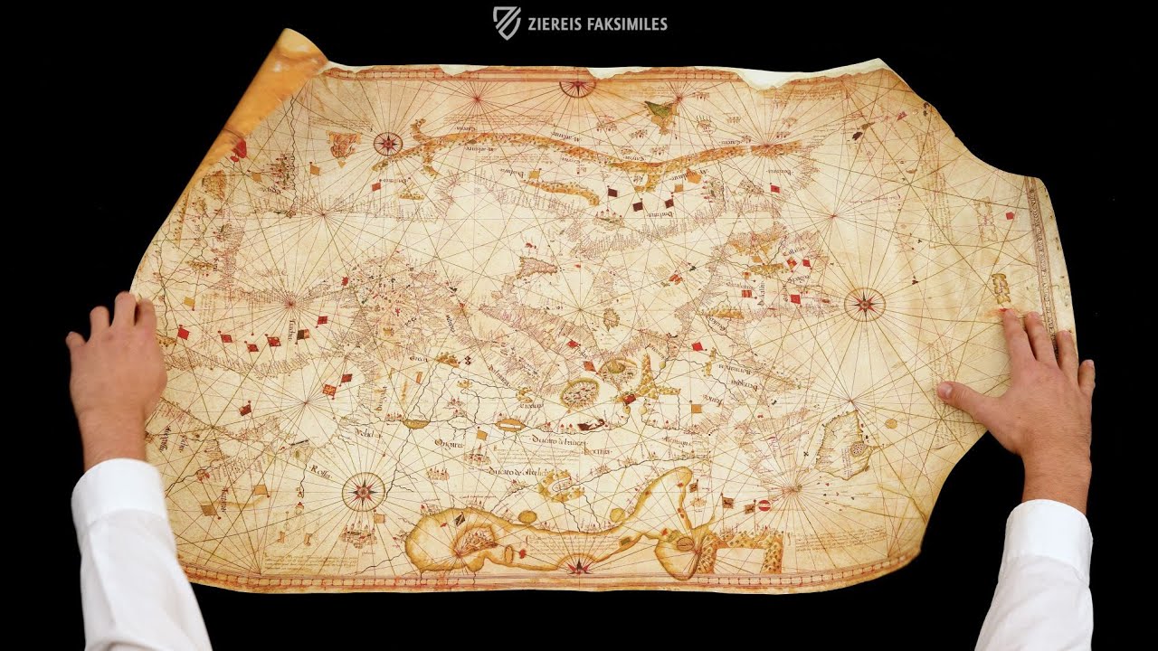
The Sea Chart of Andrea Benincasa originated ca. 1508 in Ancona, Italy and primarily shows the Mediterranean and surrounding regions, including the Red Sea, which is colored to match its name. Recorded in six different colors and adorned with elements of gold leaf, it is a wonderful specimen from the genesis of the science of modern cartography during the Italian Renaissance. Important mercantile cities like Venice are depicted with small cityscapes, while massive mountain ranges rise up in the north and south, next to which powerful contemporary rulers are enthroned. The land masses are traversed by a network of vein-like rivers, and dozens of small, colorful flags mark the countless settlements in the political landscape of the time. The sheer richness of its adornment indicates that the map was created as a luxury item for display in the home of a wealthy nobleman or merchant rather than being designed as a practical navigational chart for sailors but nonetheless represents the contemporary state of geographic knowledge.
Sea Chart of Andrea Benincasa
The Vatican Library houses some of the earliest and most precious topographical maps in the world. Found among these maps is the Sea Chart of Andrea Benincasa. This map primarily shows the Mediterranean and surrounding regions, but also parts of the British Isles and the Red Sea. It was used for navigation by medieval seafarers. The map is exceptionally richly adorned with depictions in various colors and gold accents.
The Cartographer Andrea Benincasa
Benincasa was a famous cartographer of the Italian Renaissance. From 1476 to 1508, he created important maps for the orientation of sailors and traders. He was probably educated at the cartography school of Ancona. This school was counted among the most renowned institutions of cartography worldwide. Benincasa composed at least 22 sea Rutters, which contained nautical information regarding landmarks, currents, and harbor conditions alongside the most important Rutters. The sea chart in the Vatican Library is **probably his most excellent work.
A Masterpiece of Cartography
The Sea Chart of Andrea Benincasa originated ca. 1508 and reflects the fine style of the Renaissance. The map is recorded in six different colors. In particular, his homes of Italy and the entire region surrounding the Mediterranean were depicted most realistically in the greatest detail. Some regions were less geographically-correct in their representation, e.g. it would be nearly impossible for seafarers to reach the British Isles using the information of this map. Certainly the science of cartography was still very young and Benincasa worked largely without aids. He designed the map according to his own scientific findings and medieval legends. The precious map was ennobled through the employment of gold leaf.
Codicology
- Alternative Titles
- Sea Map of Andrea Benincasa
Nautical Chart by Andrea Benincasa
Benincasa Portolan of 1508
The Andrea Benincase Map of 1508
Seekarte des Andrea Benincasa - Type
- Map on parchment
- Size / Format
- 1 map / 99.3 × 64.2 cm
- Origin
- Italy
- Date
- 1508
- Epochs
- Style
- Genre
- Language
- Script
- Gothic Textura, Gothic Hybrida
- Illustrations
- Numerous topographical illuminations, predominantly in shades of red and green, subtle gold decoration
- Content
- Luxury Portolan chart emphasizing the Mediterranean region. Representation of Northern Europe is influenced by Ptolemy. Mythical islands in the Atlantic.
- Artist / School
- Andrea Benincasa (cartographer)
")
Sea Chart of Andrea Benincasa
Egpyt and the Red Sea
Dotted with port cities, the Red Sea is colored quite literally, which was common of maps from the period. By contrast, the Nile River, lifeblood of Egypt, is represented by a thin wavy line. The city on its banks is labelled “Babillonia” or Babylon, which should be in distant Mesopotamia. To the west, a figure is seated on a golden throne and wearing a golden crown next to a compass rose while to the south, a war elephant with red tusks and a castle on its back stands ready.
")
Sea Chart of Andrea Benincasa
Focus on the Mediterranean
Reflecting Benincasa's Italian origins, the Mediterranean region occupies the center of the map. Here, the coastlines are represented with remarkable accuracy and labeled in great detail. The Aegean Sea appears as a jumble of inscriptions. The eastern edge of the map is formed by the Black Sea and the appropriately colored Red Sea, while the Atlantic Ocean with its numerous islands takes up a lot of space in the west.
To the north, the map concludes with the North Sea and the Baltic Sea, which are depicted as one elongated sea and colored green-brownish, similar to the mountain ranges depicted. The northern parts of the British Isles are also only vaguely outlined. The same applies to the North African areas in the south of the map that are not directly on the Mediterranean Sea. Thus, the map testifies both to the great skill and knowledge of European cartography at the beginning of the 16th century, but also to its gaps at that time.
")
#1 Seekarte des Andrea Benincasa
Language: German
")
")
")
")
")
")

- Treatises / Secular Books
- Apocalypses / Beatus
- Astronomy / Astrology
- Bestiaries
- Bibles / Gospels
- Chronicles / History / Law
- Geography / Maps
- Saints' Lives
- Islam / Oriental
- Judaism / Hebrew
- Single Leaf Collections
- Leonardo da Vinci
- Literature / Poetry
- Liturgical Manuscripts
- Medicine / Botany / Alchemy
- Music
- Mythology / Prophecies
- Psalters
- Other Religious Books
- Games / Hunting
- Private Devotion Books
- Other Genres
- Afghanistan
- Armenia
- Austria
- Belgium
- Belize
- Bosnia and Herzegovina
- China
- Colombia
- Costa Rica
- Croatia
- Cyprus
- Czech Republic
- Denmark
- Egypt
- El Salvador
- Ethiopia
- France
- Germany
- Greece
- Guatemala
- Honduras
- Hungary
- India
- Iran
- Iraq
- Israel
- Italy
- Japan
- Jordan
- Kazakhstan
- Kyrgyzstan
- Lebanon
- Liechtenstein
- Luxembourg
- Mexico
- Morocco
- Netherlands
- Palestine
- Panama
- Peru
- Poland
- Portugal
- Romania
- Russia
- Serbia
- Spain
- Sri Lanka
- Sweden
- Switzerland
- Syria
- Tajikistan
- Turkey
- Turkmenistan
- Ukraine
- United Kingdom
- United States
- Uzbekistan
- Vatican City
- A. Oosthoek, van Holkema & Warendorf
- Aboca Museum
- Ajuntament de Valencia
- Akademie Verlag
- Akademische Druck- u. Verlagsanstalt (ADEVA)
- Aldo Ausilio Editore - Bottega d’Erasmo
- Alecto Historical Editions
- Alkuin Verlag
- Almqvist & Wiksell
- Amilcare Pizzi
- Andreas & Andreas Verlagsbuchhandlung
- Archa 90
- Archiv Verlag
- Archivi Edizioni
- Arnold Verlag
- ARS
- Ars Magna
- Ars Millenii
- Art Market
- ArtCodex
- AyN Ediciones
- Azimuth Editions
- Badenia Verlag
- Bärenreiter-Verlag
- Belser Verlag
- Belser Verlag / WK Wertkontor
- Benziger Verlag
- Bernardinum Wydawnictwo
- BiblioGemma
- Biblioteca Apostolica Vaticana (Vaticanstadt, Vaticanstadt)
- Bibliotheca Palatina Faksimile Verlag
- Bibliotheca Rara
- Boydell & Brewer
- Bramante Edizioni
- Bredius Genootschap
- Brepols Publishers
- British Library
- Brokarte
- C. Weckesser
- Caixa Catalunya
- Canesi
- CAPSA, Ars Scriptoria
- Caratzas Brothers, Publishers
- Carus Verlag
- Casamassima Libri
- Centrum Cartographie Verlag GmbH
- Chavane Verlag
- Christian Brandstätter Verlag
- Circulo Cientifico
- Club Bibliófilo Versol
- Club du Livre
- Club Internacional del Libro
- CM Editores
- Collegium Graphicum
- Collezione Apocrifa Da Vinci
- Comissão Nacional para as Comemorações dos Descobrimentos Portugueses
- Coron Verlag
- Corvina
- CTHS
- D. S. Brewer
- Damon
- De Agostini/UTET
- De Nederlandsche Boekhandel
- De Schutter
- Deuschle & Stemmle
- Deutscher Verlag für Kunstwissenschaft
- DIAMM
- Dropmore Press
- Droz
- E. Schreiber Graphische Kunstanstalten
- Ediciones Boreal
- Ediciones Grial
- Ediclube
- Edições Inapa
- Edilan
- Editalia
- Edition Deuschle
- Edition Georg Popp
- Edition Leipzig
- Edition Libri Illustri
- Editiones Reales Sitios S. L.
- Éditions de l'Oiseau Lyre
- Editions Medicina Rara
- Editorial Casariego
- Editorial Mintzoa
- Editrice Antenore
- Editrice Velar
- Edizioni Edison
- Egeria, S.L.
- Eikon Editores
- Electa
- Emery Walker Limited
- Enciclopèdia Catalana
- Eos-Verlag
- Ephesus Publishing
- Ernst Battenberg
- Eugrammia Press
- Extraordinary Editions
- Fackelverlag
- Facsimila Art & Edition
- Facsimile Editions Ltd.
- Facsimilia Art & Edition Ebert KG
- Faksimile Verlag
- Feuermann Verlag
- Folger Shakespeare Library
- Franco Cosimo Panini Editore
- Friedrich Wittig Verlag
- Fundación Hullera Vasco-Leonesa
- G. Braziller
- Gabriele Mazzotta Editore
- Gebr. Mann Verlag
- Gesellschaft für graphische Industrie
- Getty Research Institute
- Giovanni Domenico de Rossi
- Giunti Editore
- Goldenmark Librarium
- Graffiti
- Grafica European Center of Fine Arts
- Guido Pressler
- Guillermo Blazquez
- Gustav Kiepenheuer
- H. N. Abrams
- Harrassowitz
- Harvard University Press
- Helikon
- Hendrickson Publishers
- Henning Oppermann
- Herder Verlag
- Hes & De Graaf Publishers
- Hoepli
- Holbein-Verlag
- Houghton Library
- Hugo Schmidt Verlag
- Hungarian Academy of Sciences
- Idion Verlag
- Il Bulino, edizioni d'arte
- ILte
- Imago
- Insel Verlag
- Insel-Verlag Anton Kippenberger
- Instituto de Estudios Altoaragoneses
- Instituto Nacional de Antropología e Historia
- Introligatornia Budnik Jerzy
- Istituto dell'Enciclopedia Italiana - Treccani
- Istituto Ellenico di Studi Bizantini e Postbizantini
- Istituto Geografico De Agostini
- Istituto Poligrafico e Zecca dello Stato
- Italarte Art Establishments
- Jaca Book
- Jan Thorbecke Verlag
- Johnson Reprint Corporation
- Johnson Reprint Corporation
- Jos. Baer
- Josef Stocker
- Josef Stocker-Schmid
- Jugoslavija
- Karl W. Hiersemann
- Kasper Straube
- Kaydeda Ediciones
- Kindler Verlag / Coron Verlag
- Kodansha International Ltd.
- Konrad Kölbl Verlag
- Kurt Wolff Verlag
- La Liberia dello Stato
- La Linea Editrice
- La Meta Editore
- Lambert Schneider
- Landeskreditbank Baden-Württemberg
- Leo S. Olschki
- Les Incunables
- Liber Artis
- Library of Congress
- Libreria Musicale Italiana
- Lichtdruck
- Lito Immagine Editore
- Lumen Artis
- Lund Humphries
- M. Moleiro Editor
- Maison des Sciences de l'homme et de la société de Poitiers
- Manuscriptum
- Martinus Nijhoff
- Maruzen-Yushodo Co. Ltd.
- MASA
- Massada Publishers
- McGraw-Hill
- Metropolitan Museum of Art
- Militos
- Millennium Liber
- Müller & Schindler
- Nahar - Stavit
- Nahar and Steimatzky
- National Library of Wales
- Neri Pozza
- Nova Charta
- Oceanum Verlag
- Odeon
- Omnia Arte
- Orbis Mediaevalis
- Orbis Pictus
- Österreichische Staatsdruckerei
- Oxford University Press
- Pageant Books
- Parzellers Buchverlag
- Patrimonio Ediciones
- Pattloch Verlag
- PIAF
- Pieper Verlag
- Plon-Nourrit et cie
- Poligrafiche Bolis
- Presses Universitaires de Strasbourg
- Prestel Verlag
- Princeton University Press
- Prisma Verlag
- Priuli & Verlucca, editori
- Pro Sport Verlag
- Propyläen Verlag
- Pytheas Books
- Quaternio Verlag Luzern
- Reales Sitios
- Recht-Verlag
- Reichert Verlag
- Reichsdruckerei
- Reprint Verlag
- Riehn & Reusch
- Roberto Vattori Editore
- Rosenkilde and Bagger
- Roxburghe Club
- Salerno Editrice
- Saltellus Press
- Sandoz
- Sarajevo Svjetlost
- Schöck ArtPrint Kft.
- Schulsinger Brothers
- Scolar Press
- Scrinium
- Scripta Maneant
- Scriptorium
- Shazar
- Siloé, arte y bibliofilia
- SISMEL - Edizioni del Galluzzo
- Sociedad Mexicana de Antropología
- Société des Bibliophiles & Iconophiles de Belgique
- Soncin Publishing
- Sorli Ediciones
- Stainer and Bell
- Studer
- Styria Verlag
- Sumptibus Pragopress
- Szegedi Tudomànyegyetem
- Taberna Libraria
- Tarshish Books
- Taschen
- Tempus Libri
- Testimonio Compañía Editorial
- TGB Limited Editions
- Thames and Hudson
- The Clear Vue Publishing Partnership Limited
- The Facsimile Codex
- The Folio Society
- The Marquess of Normanby
- The Orphan Hospital Ward of Israel
- The Richard III and Yorkist History Trust
- The Warburg Institute
- Tip.Le.Co
- TouchArt
- TREC Publishing House
- TRI Publishing Co.
- Trident Editore
- Tuliba Collection
- Typis Regiae Officinae Polygraphicae
- Union Verlag Berlin
- Universidad de Granada
- Universitaire Bibliotheken Leiden
- University of California Press
- University of Chicago Press
- Urs Graf
- Vallecchi
- Van Wijnen
- VCH, Acta Humaniora
- VDI Verlag
- VEB Deutscher Verlag für Musik
- Verein Schweizerischer Lithographie-Besitzer
- Verlag Anton Pustet / Andreas Verlag
- Verlag Bibliophile Drucke Josef Stocker
- Verlag der Münchner Drucke
- Verlag für Regionalgeschichte
- Verlag Styria
- Vicent Garcia Editores
- W. Turnowsky
- Waanders Printers
- Wiener Mechitharisten-Congregation (Wien, Österreich)
- Wissenschaftliche Buchgesellschaft
- Wissenschaftliche Verlagsgesellschaft
- Wydawnictwo Dolnoslaskie
- Xuntanza Editorial
- Zakład Narodowy
- Zollikofer AG