Breve Compendio de la Sphera y de la Arte de Navegar
")
Seville (Spain) — May 27th, 1551
How to make a sea astrolabe or determine the time at night: Martín Cortés de Albacar's milestone in navigation and cosmography with groundbreaking findings about the Earth's poles
Martín Cortés de Albacar (1510–1582) wrote the standard navigational textbook of the 16th century
Albacar explains the variability of magnetic declination when using a compass in different regions of the globe
It was first published on May 27th, 1551 by Antón Álvarez in Seville and enjoyed numerous translations
Breve Compendio de la Sphera y de la Arte de Navegar

")
")
")
")
")
")
")
")
")
")
")
")
")
")
")
")
")
")
")
")
")
(under 1,000€)
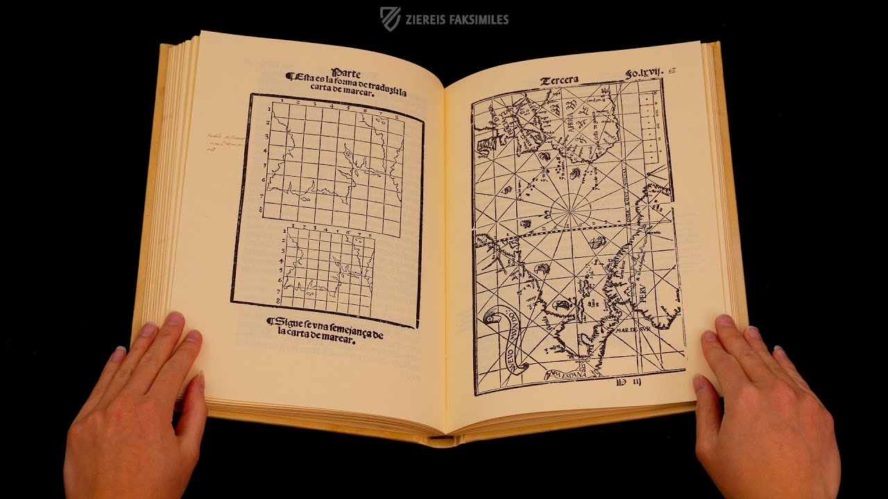
The Brief Summary of the World and the Art of Navigation, originally titled Breve Compendio de la Sphera y de la Arte de Navegar in Spanish, is a fascinating and significant piece of scientific history that explains the variability of magnetic declination when using a compass in different regions of the globe. With this work, the Spanish author and cosmographer Martín Cortés de Albacar (1510-1582) broke with the prevailing ideas of his time and completely revolutionized seafaring by establishing new standards for navigation in the 16th century. In addition to introducing new navigation methods, the work also describes the various instruments and their use, and in some cases even their manufacture at sea, including a nocturnal and an astrolabe. This Spanish first edition of the historic work was published on May 27, 1551, in Seville and is particularly well preserved in Codex R-1/145 of the Biblioteca Histórica de la Universidad de València.
Breve Compendio de la Sphera y de la Arte de Navegar
The treatise, whose full title translates to “Brief Compendium of the Globe and the Art of Navigation” in English, is usually referred to simply as Arte de Navegar. It was written by Cádiz native Martín Cortés de Albacar (1510–1582) and published on May 27th, 1551 in the Seville printing house of Antón Álvarez. Alcabar was a Spanish cosmographer whose treatise was considered to be the standard navigational textbook in the 16th century. The practical codex concisely described navigation, cosmography, and solving problems related to magnetic declination as well as models for various instruments. These include one of the first known descriptions of a nocturnal, which allows one to calculate the local time at night based upon the relative positions of at least two stars, and instructions for making and using a mariner’s astrolabe, which determines latitude. All of this is explained in easily legible Gothic script and is adorned by clear, precise woodcuts. The work went on to enjoy numerous translations, with the 1561 English translation by the alchemist Richard Eden (ca. 1520–1576) enjoying particular popularity, appearing in at least six editions, and representing the first formal navigational work in English. Thus, the Spanish original at hand was of importance not only for the land of its origin, but had a significant impact on sailors and navigators across Europe.
Codicology
- Alternative Titles
- Breve Compendio de la Sphera y de la Arte de Navegar: con nuevos instrumentos y reglas, exemplificado con muy subtiles demonstraciones
Kurze Zusammenfassung über die Welt und die Kunst des Navigierens - Size / Format
- 204 pages / 30.0 × 20.5 cm
- Origin
- Spain
- Date
- May 27th, 1551
- Epochs
- Style
- Language
- Illustrations
- Numerous, sometimes multi-layered, geographical illustrations and diagrams along with depictions of nautical instruments
- Content
- Treatise on navigation and cosmography
- Artist / School
- Martín Cortés (author)
Antón Álvarez (printer)
")
Breve Compendio de la Sphera y de la Arte de Navegar
Martín Cortés de Albacar
This somewhat different author portrait can be found at the beginning of the text and shows Martín Cortés de Albacar standing in profile, pointing to the sky with his right index finger, which is adorned with a ring. There, a glistening figure of light emerges from the clouds. On small pedestals lie various astronomical instruments that could be used to study this divine-looking celestial phenomenon. Between them lies an open book with astronomical diagrams – a self-referential representation of the codex in which the woodcut is found. The quill pen in the inkwell emphasizes the authorship of the sumptuously dressed cosmographer.
")
Breve Compendio de la Sphera y de la Arte de Navegar
Nocturnal
This fascinating, multi-layered illustration shows the structure of a so-called nocturnal. It was used by sailors to determine the position of the North Star and the stars surrounding it. On this basis, the time could be calculated at night, which was essential for precise navigation.
The accompanying text describes the construction and functioning of the instrument. The date was set on the bottom layer. The days of each month can be read in 5-step intervals. The disc attached to it indicates the 24 hours of a day. Through the hole in the middle – represented here as a star – the North Star could be sighted, while at the same time one of the surrounding stars was targeted with the pointer in the shape of a horn.
")
#1 Breve Compendio de la Sphera y de la Arte de Navegar: con nuevos instrumentos y reglas, exemplificado con muy subtiles demonstraciones
Language: Spanish
Part of the anthology “Bibliofilia antigua IV,” published by Vicent Garcia Editores.
(under 1,000€)
")
 – National Library of Russia (St. Petersburg, Russia)")
")
")

")
- Treatises / Secular Books
- Apocalypses / Beatus
- Astronomy / Astrology
- Bestiaries
- Bibles / Gospels
- Chronicles / History / Law
- Geography / Maps
- Saints' Lives
- Islam / Oriental
- Judaism / Hebrew
- Single Leaf Collections
- Leonardo da Vinci
- Literature / Poetry
- Liturgical Manuscripts
- Medicine / Botany / Alchemy
- Music
- Mythology / Prophecies
- Psalters
- Other Religious Books
- Games / Hunting
- Private Devotion Books
- Other Genres
- Afghanistan
- Armenia
- Austria
- Belgium
- Belize
- Bosnia and Herzegovina
- China
- Colombia
- Costa Rica
- Croatia
- Cyprus
- Czech Republic
- Denmark
- Egypt
- El Salvador
- Ethiopia
- France
- Germany
- Greece
- Guatemala
- Honduras
- Hungary
- India
- Iran
- Iraq
- Israel
- Italy
- Japan
- Jordan
- Kazakhstan
- Kyrgyzstan
- Lebanon
- Liechtenstein
- Luxembourg
- Mexico
- Morocco
- Netherlands
- Palestine
- Panama
- Peru
- Poland
- Portugal
- Romania
- Russia
- Serbia
- Spain
- Sri Lanka
- Sweden
- Switzerland
- Syria
- Tajikistan
- Turkey
- Turkmenistan
- Ukraine
- United Kingdom
- United States
- Uzbekistan
- Vatican City
- A. Oosthoek, van Holkema & Warendorf
- Aboca Museum
- Ajuntament de Valencia
- Akademie Verlag
- Akademische Druck- u. Verlagsanstalt (ADEVA)
- Aldo Ausilio Editore - Bottega d’Erasmo
- Alecto Historical Editions
- Alkuin Verlag
- Almqvist & Wiksell
- Amilcare Pizzi
- Andreas & Andreas Verlagsbuchhandlung
- Archa 90
- Archiv Verlag
- Archivi Edizioni
- Arnold Verlag
- ARS
- Ars Magna
- Ars Millenii
- Art Market
- ArtCodex
- AyN Ediciones
- Azimuth Editions
- Badenia Verlag
- Bärenreiter-Verlag
- Belser Verlag
- Belser Verlag / WK Wertkontor
- Benziger Verlag
- Bernardinum Wydawnictwo
- BiblioGemma
- Biblioteca Apostolica Vaticana (Vaticanstadt, Vaticanstadt)
- Bibliotheca Palatina Faksimile Verlag
- Bibliotheca Rara
- Boydell & Brewer
- Bramante Edizioni
- Bredius Genootschap
- Brepols Publishers
- British Library
- Brokarte
- C. Weckesser
- Caixa Catalunya
- Canesi
- CAPSA, Ars Scriptoria
- Caratzas Brothers, Publishers
- Carus Verlag
- Casamassima Libri
- Centrum Cartographie Verlag GmbH
- Chavane Verlag
- Christian Brandstätter Verlag
- Circulo Cientifico
- Club Bibliófilo Versol
- Club du Livre
- Club Internacional del Libro
- CM Editores
- Collegium Graphicum
- Collezione Apocrifa Da Vinci
- Comissão Nacional para as Comemorações dos Descobrimentos Portugueses
- Coron Verlag
- Corvina
- CTHS
- D. S. Brewer
- Damon
- De Agostini/UTET
- De Nederlandsche Boekhandel
- De Schutter
- Deuschle & Stemmle
- Deutscher Verlag für Kunstwissenschaft
- DIAMM
- Dropmore Press
- Droz
- E. Schreiber Graphische Kunstanstalten
- Ediciones Boreal
- Ediciones Grial
- Ediclube
- Edições Inapa
- Edilan
- Editalia
- Edition Deuschle
- Edition Georg Popp
- Edition Leipzig
- Edition Libri Illustri
- Editiones Reales Sitios S. L.
- Éditions de l'Oiseau Lyre
- Editions Medicina Rara
- Editorial Casariego
- Editorial Mintzoa
- Editrice Antenore
- Editrice Velar
- Edizioni Edison
- Egeria, S.L.
- Eikon Editores
- Electa
- Emery Walker Limited
- Enciclopèdia Catalana
- Eos-Verlag
- Ephesus Publishing
- Ernst Battenberg
- Eugrammia Press
- Extraordinary Editions
- Fackelverlag
- Facsimila Art & Edition
- Facsimile Editions Ltd.
- Facsimilia Art & Edition Ebert KG
- Faksimile Verlag
- Feuermann Verlag
- Folger Shakespeare Library
- Franco Cosimo Panini Editore
- Friedrich Wittig Verlag
- Fundación Hullera Vasco-Leonesa
- G. Braziller
- Gabriele Mazzotta Editore
- Gebr. Mann Verlag
- Gesellschaft für graphische Industrie
- Getty Research Institute
- Giovanni Domenico de Rossi
- Giunti Editore
- Goldenmark Librarium
- Graffiti
- Grafica European Center of Fine Arts
- Guido Pressler
- Guillermo Blazquez
- Gustav Kiepenheuer
- H. N. Abrams
- Harrassowitz
- Harvard University Press
- Helikon
- Hendrickson Publishers
- Henning Oppermann
- Herder Verlag
- Hes & De Graaf Publishers
- Hoepli
- Holbein-Verlag
- Houghton Library
- Hugo Schmidt Verlag
- Hungarian Academy of Sciences
- Idion Verlag
- Il Bulino, edizioni d'arte
- ILte
- Imago
- Insel Verlag
- Insel-Verlag Anton Kippenberger
- Instituto de Estudios Altoaragoneses
- Instituto Nacional de Antropología e Historia
- Introligatornia Budnik Jerzy
- Istituto dell'Enciclopedia Italiana - Treccani
- Istituto Ellenico di Studi Bizantini e Postbizantini
- Istituto Geografico De Agostini
- Istituto Poligrafico e Zecca dello Stato
- Italarte Art Establishments
- Jaca Book
- Jan Thorbecke Verlag
- Johnson Reprint Corporation
- Johnson Reprint Corporation
- Jos. Baer
- Josef Stocker
- Josef Stocker-Schmid
- Jugoslavija
- Karl W. Hiersemann
- Kasper Straube
- Kaydeda Ediciones
- Kindler Verlag / Coron Verlag
- Kodansha International Ltd.
- Konrad Kölbl Verlag
- Kurt Wolff Verlag
- La Liberia dello Stato
- La Linea Editrice
- La Meta Editore
- Lambert Schneider
- Landeskreditbank Baden-Württemberg
- Leo S. Olschki
- Les Incunables
- Liber Artis
- Library of Congress
- Libreria Musicale Italiana
- Lichtdruck
- Lito Immagine Editore
- Lumen Artis
- Lund Humphries
- M. Moleiro Editor
- Maison des Sciences de l'homme et de la société de Poitiers
- Manuscriptum
- Martinus Nijhoff
- Maruzen-Yushodo Co. Ltd.
- MASA
- Massada Publishers
- McGraw-Hill
- Metropolitan Museum of Art
- Militos
- Millennium Liber
- Müller & Schindler
- Nahar - Stavit
- Nahar and Steimatzky
- National Library of Wales
- Neri Pozza
- Nova Charta
- Oceanum Verlag
- Odeon
- Omnia Arte
- Orbis Mediaevalis
- Orbis Pictus
- Österreichische Staatsdruckerei
- Oxford University Press
- Pageant Books
- Parzellers Buchverlag
- Patrimonio Ediciones
- Pattloch Verlag
- PIAF
- Pieper Verlag
- Plon-Nourrit et cie
- Poligrafiche Bolis
- Presses Universitaires de Strasbourg
- Prestel Verlag
- Princeton University Press
- Prisma Verlag
- Priuli & Verlucca, editori
- Pro Sport Verlag
- Propyläen Verlag
- Pytheas Books
- Quaternio Verlag Luzern
- Reales Sitios
- Recht-Verlag
- Reichert Verlag
- Reichsdruckerei
- Reprint Verlag
- Riehn & Reusch
- Roberto Vattori Editore
- Rosenkilde and Bagger
- Roxburghe Club
- Salerno Editrice
- Saltellus Press
- Sandoz
- Sarajevo Svjetlost
- Schöck ArtPrint Kft.
- Schulsinger Brothers
- Scolar Press
- Scrinium
- Scripta Maneant
- Scriptorium
- Shazar
- Siloé, arte y bibliofilia
- SISMEL - Edizioni del Galluzzo
- Sociedad Mexicana de Antropología
- Société des Bibliophiles & Iconophiles de Belgique
- Soncin Publishing
- Sorli Ediciones
- Stainer and Bell
- Studer
- Styria Verlag
- Sumptibus Pragopress
- Szegedi Tudomànyegyetem
- Taberna Libraria
- Tarshish Books
- Taschen
- Tempus Libri
- Testimonio Compañía Editorial
- TGB Limited Editions
- Thames and Hudson
- The Clear Vue Publishing Partnership Limited
- The Facsimile Codex
- The Folio Society
- The Marquess of Normanby
- The Orphan Hospital Ward of Israel
- The Richard III and Yorkist History Trust
- The Warburg Institute
- Tip.Le.Co
- TouchArt
- TREC Publishing House
- TRI Publishing Co.
- Trident Editore
- Tuliba Collection
- Typis Regiae Officinae Polygraphicae
- Union Verlag Berlin
- Universidad de Granada
- Universitaire Bibliotheken Leiden
- University of California Press
- University of Chicago Press
- Urs Graf
- Vallecchi
- Van Wijnen
- VCH, Acta Humaniora
- VDI Verlag
- VEB Deutscher Verlag für Musik
- Verein Schweizerischer Lithographie-Besitzer
- Verlag Anton Pustet / Andreas Verlag
- Verlag Bibliophile Drucke Josef Stocker
- Verlag der Münchner Drucke
- Verlag für Regionalgeschichte
- Verlag Styria
- Vicent Garcia Editores
- W. Turnowsky
- Waanders Printers
- Wiener Mechitharisten-Congregation (Wien, Österreich)
- Wissenschaftliche Buchgesellschaft
- Wissenschaftliche Verlagsgesellschaft
- Wydawnictwo Dolnoslaskie
- Xuntanza Editorial
- Zakład Narodowy
- Zollikofer AG