Gerardus Mercator - Atlas sive cosmographica
")
Duisburg (Germany) — 1585–1595
Maps in modern Mercator projection created by the greatest cartographer since Ptolemy: Gerardus Mercator's famous atlas as a milestone in geography and a masterpiece of Renaissance book illumination
Gerardus Mercator (1512–94) was regarded as the Ptolemy of his time
He is the creator of the Mercator projection still used in modern maps today
This atlas is not only a milestone of geography, but an absolute masterpiece of early modern illumination
Gerardus Mercator - Atlas sive cosmographica

")
")
")
")
")
")
")
")
")
")
")
")
")
")
")
")
")
")
")
")
")
")
")
")
")
")
(1,000€ - 3,000€)
Our modern geography and navigation goes back to the work of the great polymath Gerardus Mercator. The scientist was already seen as the Ptolemy of his time by his contemporaries. His significance for mathematics, philosophy, and cartography above all was unrivaled for centuries. His cosmographic atlas laid the cornerstone for the science of geography. The comprehensive work Atlas sive cosmographica is captivating not only because of its systematic correctness and precision, but is also one of the most beautiful illuminated codices of the Renaissance.
Gerardus Mercator - Atlas sive cosmographica
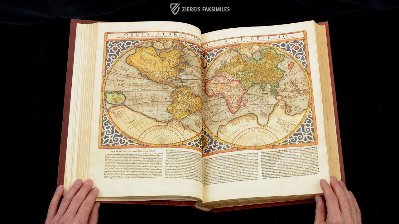
The atlas by Gerardus Mercator is without a doubt the first and most important bound cartographical work ever created. His great and famous project bears the name Atlas sive Cosmographicae meditationes de fabrica mundi et fabricati figura, which can be translated as “Atlas or cosmographical meditations upon the creation of the universe, and the universe as created”. Aside from depictions of the world, the continents, and countries, the comprehensive work is also comprised of theoretical writings concerning the history of creation. The atlas is not only a milestone of geography, which wins people over with its brilliantly colored illustrations, but is also an absolute masterpiece of early modern illumination.
The Great Scholar Gerardus Mercator
Gerardus Mercator, whose actual name was Gerhard Krämer, was a polymath and one of the great scientists of the 16th century. He was a mathematician, philosopher, theologian, and above all set benchmarks in his occupation as a geographer and cartographer. He was regarded as the Ptolemy of his time during his own lifetime and was famous even in the Arab-Islamic world. Mercator is still known and remains present today above all because of the Mercator Projection, which was discovered by and named after him, and is still used in modern cartography. His comprehensive cosmographic atlas fundamentally changed the medieval worldview. After its publication, it was not only the most important navigational aid for travelers on land and sea, but also contained geographic information that was completely unknown to the population of the medieval world. Mercator himself was not able to witness the publication of his masterpiece – the atlas was published one year after the master’s death by his son Rumold.
A Masterpiece of Art and Science
The Mercator atlas is an artwork of special importance. Its system and its precision, which revolutionized the geography of the Middle Ages, is captivating. This level of detail corresponds to its markedly high-quality, artistic character. Information and aesthetic are outstandingly united with one another in this work, which is presented completely in the style of the Renaissance. The illustrated maps bear titles in elaborate, heraldic-looking quill writing. Water areas are designed with fish and ships, magnificent fields and landscapes adorn the pages in sumptuous green. The incomparable masterpiece was already unbelievably precious at the time of its creation and was only affordable for distinctly wealthy members of medieval society. Original specimens of the atlas could be found e.g. in the possession of Queen Elizabeth I and Ferdinand II de Medici, the Duke of Tuscany.
Codicology
- Alternative Titles
- Atlas Merkatora
Atlas sive cosmographicae meditationes de fabrica mvndi et fabricati figvra
Mercator-Atlas
Mercatoratlas - Type
- Map on paper
- Size / Format
- 504 pages / 44.0 × 32.0 cm
- Origin
- Germany
- Date
- 1585–1595
- Epochs
- Style
- Genre
- Language
- Artist / School
- Gerhard Kremer, called Gerardus Mercator (1512–94)
Rumold Mercator (1545–99) - Previous Owners
- First section: Queen Elizabeth I (1533–1603)
Second section: Cardinal Ferdinando II de’ Medici, the Grand Duke of Tuscany (1610–70)
")
Gerardus Mercator - Atlas sive cosmographica
Author Portrait
This wonderfully colored woodcut portrait of Gerardus Mercator is extremely detailed, especially with respect to his beard, hands, and the fall of folds in the sleeve. He is holding a globe, the production of which was a primary source of his income, and a compass in his right hand is placed directly upon the North Pole – an allusion to medieval depictions of God as architect of the universe. The mandorla surrounding the portrait praises Mercator’s accomplishments.
")
Atlas sive cosmographica
EVROPA
Delicately shaded and obviously created with respect to Mercator projection, this is one of the earliest modern maps of Europe and is remarkable for its level of accuracy thanks to the systematic way in which it was created. Upon closer examination, one can appreciate the tremendous attention to detail that was required in creating this woodcut, such as the coastline of Norway.
Although originating from the late–16th century, many of the boundaries illustrated in this map are surprisingly modern. However, the boundaries depicted in the map tend to be more cultural and linguistic than political. For example, it would be impractical to attempt to depict the thousand nations of the Holy Roman Empire at this scale.
")
#1 Atlas Merkatora
(1,000€ - 3,000€)

")
")
")
")
")

- Treatises / Secular Books
- Apocalypses / Beatus
- Astronomy / Astrology
- Bestiaries
- Bibles / Gospels
- Chronicles / History / Law
- Geography / Maps
- Saints' Lives
- Islam / Oriental
- Judaism / Hebrew
- Single Leaf Collections
- Leonardo da Vinci
- Literature / Poetry
- Liturgical Manuscripts
- Medicine / Botany / Alchemy
- Music
- Mythology / Prophecies
- Psalters
- Other Religious Books
- Games / Hunting
- Private Devotion Books
- Other Genres
- Afghanistan
- Armenia
- Austria
- Belgium
- Belize
- Bosnia and Herzegovina
- China
- Colombia
- Costa Rica
- Croatia
- Cyprus
- Czech Republic
- Denmark
- Egypt
- El Salvador
- Ethiopia
- France
- Germany
- Greece
- Guatemala
- Honduras
- Hungary
- India
- Iran
- Iraq
- Israel
- Italy
- Japan
- Jordan
- Kazakhstan
- Kyrgyzstan
- Lebanon
- Liechtenstein
- Luxembourg
- Mexico
- Morocco
- Netherlands
- Palestine
- Panama
- Peru
- Poland
- Portugal
- Romania
- Russia
- Serbia
- Spain
- Sri Lanka
- Sweden
- Switzerland
- Syria
- Tajikistan
- Turkey
- Turkmenistan
- Ukraine
- United Kingdom
- United States
- Uzbekistan
- Vatican City
- A. Oosthoek, van Holkema & Warendorf
- Aboca Museum
- Ajuntament de Valencia
- Akademie Verlag
- Akademische Druck- u. Verlagsanstalt (ADEVA)
- Aldo Ausilio Editore - Bottega d’Erasmo
- Alecto Historical Editions
- Alkuin Verlag
- Almqvist & Wiksell
- Amilcare Pizzi
- Andreas & Andreas Verlagsbuchhandlung
- Archa 90
- Archiv Verlag
- Archivi Edizioni
- Arnold Verlag
- ARS
- Ars Magna
- Ars Millenii
- Art Market
- ArtCodex
- AyN Ediciones
- Azimuth Editions
- Badenia Verlag
- Bärenreiter-Verlag
- Belser Verlag
- Belser Verlag / WK Wertkontor
- Benziger Verlag
- Bernardinum Wydawnictwo
- BiblioGemma
- Biblioteca Apostolica Vaticana (Vaticanstadt, Vaticanstadt)
- Bibliotheca Palatina Faksimile Verlag
- Bibliotheca Rara
- Boydell & Brewer
- Bramante Edizioni
- Bredius Genootschap
- Brepols Publishers
- British Library
- Brokarte
- C. Weckesser
- Caixa Catalunya
- Canesi
- CAPSA, Ars Scriptoria
- Caratzas Brothers, Publishers
- Carus Verlag
- Casamassima Libri
- Centrum Cartographie Verlag GmbH
- Chavane Verlag
- Christian Brandstätter Verlag
- Circulo Cientifico
- Club Bibliófilo Versol
- Club du Livre
- Club Internacional del Libro
- CM Editores
- Collegium Graphicum
- Collezione Apocrifa Da Vinci
- Comissão Nacional para as Comemorações dos Descobrimentos Portugueses
- Coron Verlag
- Corvina
- CTHS
- D. S. Brewer
- Damon
- De Agostini/UTET
- De Nederlandsche Boekhandel
- De Schutter
- Deuschle & Stemmle
- Deutscher Verlag für Kunstwissenschaft
- DIAMM
- Dropmore Press
- Droz
- E. Schreiber Graphische Kunstanstalten
- Ediciones Boreal
- Ediciones Grial
- Ediclube
- Edições Inapa
- Edilan
- Editalia
- Edition Deuschle
- Edition Georg Popp
- Edition Leipzig
- Edition Libri Illustri
- Editiones Reales Sitios S. L.
- Éditions de l'Oiseau Lyre
- Editions Medicina Rara
- Editorial Casariego
- Editorial Mintzoa
- Editrice Antenore
- Editrice Velar
- Edizioni Edison
- Egeria, S.L.
- Eikon Editores
- Electa
- Emery Walker Limited
- Enciclopèdia Catalana
- Eos-Verlag
- Ephesus Publishing
- Ernst Battenberg
- Eugrammia Press
- Extraordinary Editions
- Fackelverlag
- Facsimila Art & Edition
- Facsimile Editions Ltd.
- Facsimilia Art & Edition Ebert KG
- Faksimile Verlag
- Feuermann Verlag
- Folger Shakespeare Library
- Franco Cosimo Panini Editore
- Friedrich Wittig Verlag
- Fundación Hullera Vasco-Leonesa
- G. Braziller
- Gabriele Mazzotta Editore
- Gebr. Mann Verlag
- Gesellschaft für graphische Industrie
- Getty Research Institute
- Giovanni Domenico de Rossi
- Giunti Editore
- Goldenmark Librarium
- Graffiti
- Grafica European Center of Fine Arts
- Guido Pressler
- Guillermo Blazquez
- Gustav Kiepenheuer
- H. N. Abrams
- Harrassowitz
- Harvard University Press
- Helikon
- Hendrickson Publishers
- Henning Oppermann
- Herder Verlag
- Hes & De Graaf Publishers
- Hoepli
- Holbein-Verlag
- Houghton Library
- Hugo Schmidt Verlag
- Hungarian Academy of Sciences
- Idion Verlag
- Il Bulino, edizioni d'arte
- ILte
- Imago
- Insel Verlag
- Insel-Verlag Anton Kippenberger
- Instituto de Estudios Altoaragoneses
- Instituto Nacional de Antropología e Historia
- Introligatornia Budnik Jerzy
- Istituto dell'Enciclopedia Italiana - Treccani
- Istituto Ellenico di Studi Bizantini e Postbizantini
- Istituto Geografico De Agostini
- Istituto Poligrafico e Zecca dello Stato
- Italarte Art Establishments
- Jaca Book
- Jan Thorbecke Verlag
- Johnson Reprint Corporation
- Johnson Reprint Corporation
- Jos. Baer
- Josef Stocker
- Josef Stocker-Schmid
- Jugoslavija
- Karl W. Hiersemann
- Kasper Straube
- Kaydeda Ediciones
- Kindler Verlag / Coron Verlag
- Kodansha International Ltd.
- Konrad Kölbl Verlag
- Kurt Wolff Verlag
- La Liberia dello Stato
- La Linea Editrice
- La Meta Editore
- Lambert Schneider
- Landeskreditbank Baden-Württemberg
- Leo S. Olschki
- Les Incunables
- Liber Artis
- Library of Congress
- Libreria Musicale Italiana
- Lichtdruck
- Lito Immagine Editore
- Lumen Artis
- Lund Humphries
- M. Moleiro Editor
- Maison des Sciences de l'homme et de la société de Poitiers
- Manuscriptum
- Martinus Nijhoff
- Maruzen-Yushodo Co. Ltd.
- MASA
- Massada Publishers
- McGraw-Hill
- Metropolitan Museum of Art
- Militos
- Millennium Liber
- Müller & Schindler
- Nahar - Stavit
- Nahar and Steimatzky
- National Library of Wales
- Neri Pozza
- Nova Charta
- Oceanum Verlag
- Odeon
- Omnia Arte
- Orbis Mediaevalis
- Orbis Pictus
- Österreichische Staatsdruckerei
- Oxford University Press
- Pageant Books
- Parzellers Buchverlag
- Patrimonio Ediciones
- Pattloch Verlag
- PIAF
- Pieper Verlag
- Plon-Nourrit et cie
- Poligrafiche Bolis
- Presses Universitaires de Strasbourg
- Prestel Verlag
- Princeton University Press
- Prisma Verlag
- Priuli & Verlucca, editori
- Pro Sport Verlag
- Propyläen Verlag
- Pytheas Books
- Quaternio Verlag Luzern
- Reales Sitios
- Recht-Verlag
- Reichert Verlag
- Reichsdruckerei
- Reprint Verlag
- Riehn & Reusch
- Roberto Vattori Editore
- Rosenkilde and Bagger
- Roxburghe Club
- Salerno Editrice
- Saltellus Press
- Sandoz
- Sarajevo Svjetlost
- Schöck ArtPrint Kft.
- Schulsinger Brothers
- Scolar Press
- Scrinium
- Scripta Maneant
- Scriptorium
- Shazar
- Siloé, arte y bibliofilia
- SISMEL - Edizioni del Galluzzo
- Sociedad Mexicana de Antropología
- Société des Bibliophiles & Iconophiles de Belgique
- Soncin Publishing
- Sorli Ediciones
- Stainer and Bell
- Studer
- Styria Verlag
- Sumptibus Pragopress
- Szegedi Tudomànyegyetem
- Taberna Libraria
- Tarshish Books
- Taschen
- Tempus Libri
- Testimonio Compañía Editorial
- TGB Limited Editions
- Thames and Hudson
- The Clear Vue Publishing Partnership Limited
- The Facsimile Codex
- The Folio Society
- The Marquess of Normanby
- The Orphan Hospital Ward of Israel
- The Richard III and Yorkist History Trust
- The Warburg Institute
- Tip.Le.Co
- TouchArt
- TREC Publishing House
- TRI Publishing Co.
- Trident Editore
- Tuliba Collection
- Typis Regiae Officinae Polygraphicae
- Union Verlag Berlin
- Universidad de Granada
- Universitaire Bibliotheken Leiden
- University of California Press
- University of Chicago Press
- Urs Graf
- Vallecchi
- Van Wijnen
- VCH, Acta Humaniora
- VDI Verlag
- VEB Deutscher Verlag für Musik
- Verein Schweizerischer Lithographie-Besitzer
- Verlag Anton Pustet / Andreas Verlag
- Verlag Bibliophile Drucke Josef Stocker
- Verlag der Münchner Drucke
- Verlag für Regionalgeschichte
- Verlag Styria
- Vicent Garcia Editores
- W. Turnowsky
- Waanders Printers
- Wiener Mechitharisten-Congregation (Wien, Österreich)
- Wissenschaftliche Buchgesellschaft
- Wissenschaftliche Verlagsgesellschaft
- Wydawnictwo Dolnoslaskie
- Xuntanza Editorial
- Zakład Narodowy
- Zollikofer AG