Mercator Atlas of 1595
")
Germany — First part: 1585;Second part: 1589; Third part: 1595
A milestone of cartography and the template for all later atlases: Gerardus Mercator's posthumously published pictorial atlas from 1595 contributed to a completely new perspective on the world
The polymath Gerardus Mercator (1512–1594) was known as the Ptolemy of his day
The inventor of the modern atlas was celebrated as far away as the Islamic-Arab world
Published posthumously by his son Rumold, his 1595 atlas became the template for all cartographic works
Mercator Atlas of 1595

")
")
")
")
")
")
")
")
")
")
")
")
")
")
")
")
")
(under 1,000€)
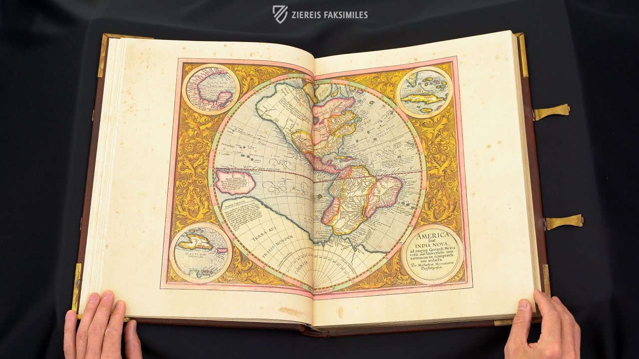
With his large overview maps and detailed depictions of specific countries and regions, the humanist and polymath Gerardus Mercator (1512–1594) created a milestone of geography. In addition, he was the first to use the term "Atlas" for a collection of maps and thus created the first and most important bound cartographic work. His Atlas, sive Cosmographicae Meditationes de Fabrica Mundi et fabricati figura was published posthumously by his son Rumold in 1595. With its innovative representations of the world, the continents, and individual countries it fundamentally changed the early modern perspective on the world, still having an impact today. However, besides the impressive scientific, geographical precision, it was also the 57 double-page colored copperplate engravings of masterly quality as well as the four artistically composed title pages that made the work so appealing even then and give us today a wonderful insight into the fascinating world of the Renaissance.
Mercator Atlas of 1595
Mercator's World Atlas of 1595 is undoubtedly the primary work of 16th century cartography. The polymath Gerardus Mercator (1512–1594), whose fame even extended to the the Islamic-Arab world, was already celebrated during his lifetime as the Ptolemy of his day. He completed his largest project, the Atlas, sive Cosmographicae meditation de Fabrica Mundi et fabricati figura, only shortly before his death, it was thus posthumously published in 1595 by his son Rumold. The edition at hand assembles 57 double-sided maps and tables of this milestone of cartography, which still inspires with large overview maps of the world and detailed representations of individual countries and regions.
The Polymath from Flanders
Gerardus Mercator was born on March 5th, 1512 near Antwerp, in modern Belgium. After being accused of heresy in his homeland, he moved with his family to Duisburg in 1552, where he became professor of cosmography at the newly founded university. In 1537, he began producing globes, wall maps and scientific instruments made of copper, which he created as several commissions for Emperor Charles V (1500–1558). His greatest invention is the Mercator projection, which was first recorded in 1569 on a 21-sheet wall map of the world. It is the first accurate and geographically precise representation of the earth.
The First atlas
For his primary work, the polymath Mercator used the term "Atlas" for the first time to denote a collection of maps. Thus, the concept was style-forming for a whole genre and became the template for all following cartographic works. The aim of the engravings was to give an all-encompassing description of heaven and earth, including theology and history. With his five-part work, Mercator was able to fundamentally change the medieval worldview with new geographical information and to develop the most important navigation aid for travelers on land and water.
Precision Meets Aesthetics
However, this first and most important bound cartographic work ever created not only captivates with scientific geographic knowledge, but also because of its artistically excellent paintings. This unique combination of precision and aesthetics can be seen in the blue waters with their small fishes and imposing ships, as well as in the magnificent landscapes and meadows, which shine in a lush green. Furthermore, each card carries a title in elaborate pen, which looks almost three-dimensional.
Codicology
- Alternative Titles
- Atlas sive cosmographicae meditationes de fabrica mundi et fabricati figura
Mercator Weltatlas 1595
Mercatoratlas - Size / Format
- 258 pages / 45.0 × 33.0 cm
- Origin
- Germany
- Date
- First part: 1585;Second part: 1589; Third part: 1595
- Epochs
- Style
- Genre
- Language
- Illustrations
- 57 colourized double-page maps and 4 elaborate title pages
- Content
- Selection of 57 double pages maps of the Mercator Atlas from 1595
- Artist / School
- Gerardus Mercator (1512–94)
")
")
Mercator Atlas of 1595
Bohemia
The map GERMANIA shows the external borders of the Holy Roman Empire in yellow, but there is a strange ring of yellow inside of it: Bohemia. Since the execution of Jan Hus for heresy in 1415 and the resulting Hussite Wars, Bohemia experienced various periods of semi-autonomy and even outright independence as they successfully fought off various invading armies. These religious and political differences would ultimate boil over into the Bohemian Revolt that sparked the 30 Years’ War in 1618.
")
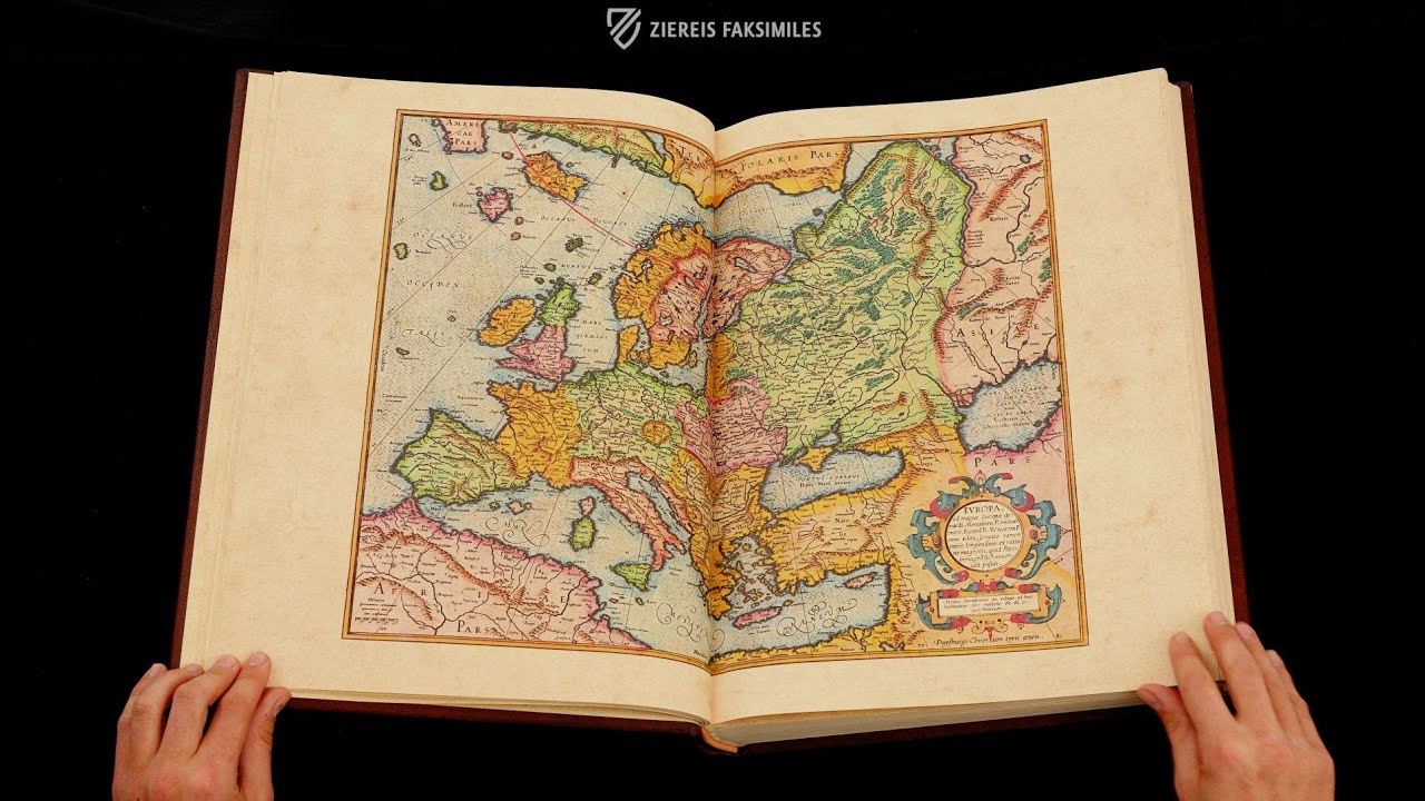
Mercator Atlas of 1595
EVROPA
This double-page map of Europe is a fantastic specimen of late–16th century cartography, which benefitted greatly from the knowledge gathered in the course of the Age of Exploration. From the Russian steppe to the Atlantic coast of Spain, and from the Nile Delta to the icy shores of Greenland and the Arctic, Europe is depicted with a perfect blend of art and science.
Political boundaries are distinguished by color, although the Kingdom of Bohemia is segregated from the rest of the Holy Roman Empire for reasons that are unclear. Topographical features are depicted with great accuracy including coastlines, rivers, forests, and mountain ranges. Finally, it has the cylindrical map projection invented by and named for the author – “Mercator projection”.
")
#1 Mercator Weltatlas 1595 - Limited Edition
Language: German
(under 1,000€)
#2 Mercator Weltatlas 1595 - Standard Edition
")
")
")
")
")
")
")
")
")
")
")
")
")
")
")
")
")
")
")
")
")
")
")
")
Language: German
(under 1,000€)
")

")
")
")
")
- Treatises / Secular Books
- Apocalypses / Beatus
- Astronomy / Astrology
- Bestiaries
- Bibles / Gospels
- Chronicles / History / Law
- Geography / Maps
- Saints' Lives
- Islam / Oriental
- Judaism / Hebrew
- Single Leaf Collections
- Leonardo da Vinci
- Literature / Poetry
- Liturgical Manuscripts
- Medicine / Botany / Alchemy
- Music
- Mythology / Prophecies
- Psalters
- Other Religious Books
- Games / Hunting
- Private Devotion Books
- Other Genres
- Afghanistan
- Armenia
- Austria
- Belgium
- Belize
- Bosnia and Herzegovina
- China
- Colombia
- Costa Rica
- Croatia
- Cyprus
- Czech Republic
- Denmark
- Egypt
- El Salvador
- Ethiopia
- France
- Germany
- Greece
- Guatemala
- Honduras
- Hungary
- India
- Iran
- Iraq
- Israel
- Italy
- Japan
- Jordan
- Kazakhstan
- Kyrgyzstan
- Lebanon
- Liechtenstein
- Luxembourg
- Mexico
- Morocco
- Netherlands
- Palestine
- Panama
- Peru
- Poland
- Portugal
- Romania
- Russia
- Serbia
- Spain
- Sri Lanka
- Sweden
- Switzerland
- Syria
- Tajikistan
- Turkey
- Turkmenistan
- Ukraine
- United Kingdom
- United States
- Uzbekistan
- Vatican City
- A. Oosthoek, van Holkema & Warendorf
- Aboca Museum
- Ajuntament de Valencia
- Akademie Verlag
- Akademische Druck- u. Verlagsanstalt (ADEVA)
- Aldo Ausilio Editore - Bottega d’Erasmo
- Alecto Historical Editions
- Alkuin Verlag
- Almqvist & Wiksell
- Amilcare Pizzi
- Andreas & Andreas Verlagsbuchhandlung
- Archa 90
- Archiv Verlag
- Archivi Edizioni
- Arnold Verlag
- ARS
- Ars Magna
- Ars Millenii
- Art Market
- ArtCodex
- AyN Ediciones
- Azimuth Editions
- Badenia Verlag
- Bärenreiter-Verlag
- Belser Verlag
- Belser Verlag / WK Wertkontor
- Benziger Verlag
- Bernardinum Wydawnictwo
- BiblioGemma
- Biblioteca Apostolica Vaticana (Vaticanstadt, Vaticanstadt)
- Bibliotheca Palatina Faksimile Verlag
- Bibliotheca Rara
- Boydell & Brewer
- Bramante Edizioni
- Bredius Genootschap
- Brepols Publishers
- British Library
- Brokarte
- C. Weckesser
- Caixa Catalunya
- Canesi
- CAPSA, Ars Scriptoria
- Caratzas Brothers, Publishers
- Carus Verlag
- Casamassima Libri
- Centrum Cartographie Verlag GmbH
- Chavane Verlag
- Christian Brandstätter Verlag
- Circulo Cientifico
- Club Bibliófilo Versol
- Club du Livre
- Club Internacional del Libro
- CM Editores
- Collegium Graphicum
- Collezione Apocrifa Da Vinci
- Comissão Nacional para as Comemorações dos Descobrimentos Portugueses
- Coron Verlag
- Corvina
- CTHS
- D. S. Brewer
- Damon
- De Agostini/UTET
- De Nederlandsche Boekhandel
- De Schutter
- Deuschle & Stemmle
- Deutscher Verlag für Kunstwissenschaft
- DIAMM
- Dropmore Press
- Droz
- E. Schreiber Graphische Kunstanstalten
- Ediciones Boreal
- Ediciones Grial
- Ediclube
- Edições Inapa
- Edilan
- Editalia
- Edition Deuschle
- Edition Georg Popp
- Edition Leipzig
- Edition Libri Illustri
- Editiones Reales Sitios S. L.
- Éditions de l'Oiseau Lyre
- Editions Medicina Rara
- Editorial Casariego
- Editorial Mintzoa
- Editrice Antenore
- Editrice Velar
- Edizioni Edison
- Egeria, S.L.
- Eikon Editores
- Electa
- Emery Walker Limited
- Enciclopèdia Catalana
- Eos-Verlag
- Ephesus Publishing
- Ernst Battenberg
- Eugrammia Press
- Extraordinary Editions
- Fackelverlag
- Facsimila Art & Edition
- Facsimile Editions Ltd.
- Facsimilia Art & Edition Ebert KG
- Faksimile Verlag
- Feuermann Verlag
- Folger Shakespeare Library
- Franco Cosimo Panini Editore
- Friedrich Wittig Verlag
- Fundación Hullera Vasco-Leonesa
- G. Braziller
- Gabriele Mazzotta Editore
- Gebr. Mann Verlag
- Gesellschaft für graphische Industrie
- Getty Research Institute
- Giovanni Domenico de Rossi
- Giunti Editore
- Goldenmark Librarium
- Graffiti
- Grafica European Center of Fine Arts
- Guido Pressler
- Guillermo Blazquez
- Gustav Kiepenheuer
- H. N. Abrams
- Harrassowitz
- Harvard University Press
- Helikon
- Hendrickson Publishers
- Henning Oppermann
- Herder Verlag
- Hes & De Graaf Publishers
- Hoepli
- Holbein-Verlag
- Houghton Library
- Hugo Schmidt Verlag
- Hungarian Academy of Sciences
- Idion Verlag
- Il Bulino, edizioni d'arte
- ILte
- Imago
- Insel Verlag
- Insel-Verlag Anton Kippenberger
- Instituto de Estudios Altoaragoneses
- Instituto Nacional de Antropología e Historia
- Introligatornia Budnik Jerzy
- Istituto dell'Enciclopedia Italiana - Treccani
- Istituto Ellenico di Studi Bizantini e Postbizantini
- Istituto Geografico De Agostini
- Istituto Poligrafico e Zecca dello Stato
- Italarte Art Establishments
- Jaca Book
- Jan Thorbecke Verlag
- Johnson Reprint Corporation
- Johnson Reprint Corporation
- Jos. Baer
- Josef Stocker
- Josef Stocker-Schmid
- Jugoslavija
- Karl W. Hiersemann
- Kasper Straube
- Kaydeda Ediciones
- Kindler Verlag / Coron Verlag
- Kodansha International Ltd.
- Konrad Kölbl Verlag
- Kurt Wolff Verlag
- La Liberia dello Stato
- La Linea Editrice
- La Meta Editore
- Lambert Schneider
- Landeskreditbank Baden-Württemberg
- Leo S. Olschki
- Les Incunables
- Liber Artis
- Library of Congress
- Libreria Musicale Italiana
- Lichtdruck
- Lito Immagine Editore
- Lumen Artis
- Lund Humphries
- M. Moleiro Editor
- Maison des Sciences de l'homme et de la société de Poitiers
- Manuscriptum
- Martinus Nijhoff
- Maruzen-Yushodo Co. Ltd.
- MASA
- Massada Publishers
- McGraw-Hill
- Metropolitan Museum of Art
- Militos
- Millennium Liber
- Müller & Schindler
- Nahar - Stavit
- Nahar and Steimatzky
- National Library of Wales
- Neri Pozza
- Nova Charta
- Oceanum Verlag
- Odeon
- Omnia Arte
- Orbis Mediaevalis
- Orbis Pictus
- Österreichische Staatsdruckerei
- Oxford University Press
- Pageant Books
- Parzellers Buchverlag
- Patrimonio Ediciones
- Pattloch Verlag
- PIAF
- Pieper Verlag
- Plon-Nourrit et cie
- Poligrafiche Bolis
- Presses Universitaires de Strasbourg
- Prestel Verlag
- Princeton University Press
- Prisma Verlag
- Priuli & Verlucca, editori
- Pro Sport Verlag
- Propyläen Verlag
- Pytheas Books
- Quaternio Verlag Luzern
- Reales Sitios
- Recht-Verlag
- Reichert Verlag
- Reichsdruckerei
- Reprint Verlag
- Riehn & Reusch
- Roberto Vattori Editore
- Rosenkilde and Bagger
- Roxburghe Club
- Salerno Editrice
- Saltellus Press
- Sandoz
- Sarajevo Svjetlost
- Schöck ArtPrint Kft.
- Schulsinger Brothers
- Scolar Press
- Scrinium
- Scripta Maneant
- Scriptorium
- Shazar
- Siloé, arte y bibliofilia
- SISMEL - Edizioni del Galluzzo
- Sociedad Mexicana de Antropología
- Société des Bibliophiles & Iconophiles de Belgique
- Soncin Publishing
- Sorli Ediciones
- Stainer and Bell
- Studer
- Styria Verlag
- Sumptibus Pragopress
- Szegedi Tudomànyegyetem
- Taberna Libraria
- Tarshish Books
- Taschen
- Tempus Libri
- Testimonio Compañía Editorial
- TGB Limited Editions
- Thames and Hudson
- The Clear Vue Publishing Partnership Limited
- The Facsimile Codex
- The Folio Society
- The Marquess of Normanby
- The Orphan Hospital Ward of Israel
- The Richard III and Yorkist History Trust
- The Warburg Institute
- Tip.Le.Co
- TouchArt
- TREC Publishing House
- TRI Publishing Co.
- Trident Editore
- Tuliba Collection
- Typis Regiae Officinae Polygraphicae
- Union Verlag Berlin
- Universidad de Granada
- Universitaire Bibliotheken Leiden
- University of California Press
- University of Chicago Press
- Urs Graf
- Vallecchi
- Van Wijnen
- VCH, Acta Humaniora
- VDI Verlag
- VEB Deutscher Verlag für Musik
- Verein Schweizerischer Lithographie-Besitzer
- Verlag Anton Pustet / Andreas Verlag
- Verlag Bibliophile Drucke Josef Stocker
- Verlag der Münchner Drucke
- Verlag für Regionalgeschichte
- Verlag Styria
- Vicent Garcia Editores
- W. Turnowsky
- Waanders Printers
- Wiener Mechitharisten-Congregation (Wien, Österreich)
- Wissenschaftliche Buchgesellschaft
- Wissenschaftliche Verlagsgesellschaft
- Wydawnictwo Dolnoslaskie
- Xuntanza Editorial
- Zakład Narodowy
- Zollikofer AG