Mercator Atlas - Codex Berlin
")
Germany — First part: 1585; Second part: 1589; Third part: 1595
The world's first modern atlas: scientific knowledge and refined art in the opus magnum of the great Gerhard Mercator with 107 masterfully engraved and geographically correct land and sea maps
The magnum opus of Gerhard Mercator (1512–94) masterfully combined scientific geographical insights with refined art
He is considered to be the eponym of the modern “atlas” book and was of incalculable value for navigation
3 parts with 107 magnificently colored copperplate engravings of detailed, geographically correct maps in their original order
Mercator Atlas - Codex Berlin

")
")
")
")
")
")
")
")
")
")
")
")
")
")
")
")
")
")
(1,000€ - 3,000€)
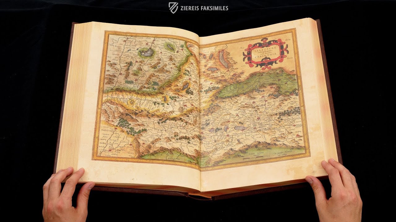
The Mercator Atlas of the humanist and polymath Gerhard Mercator (1512–1594) was created in three parts between 1585 and 1595 and masterfully combines the scientific, geographical knowledge of the time with the great art of copperplate engraving. 107 masterfully engraved and geographically correct, mostly double-page land and sea maps bring the world known in Europe at that time on paper and give us today an insight into the world of the Renaissance. Remarkably, a large number of the copper engravings are actually by Mercator himself, whose greatest cartographic achievement was the first equiangular and geographically precise depiction of the Earth. The work is also considered to be the eponym of the modern “atlas” book and was of incalculable value for navigation at sea for a long time to come. With it, Mercator laid the foundation for the science of cartography, which still has an impact today. This magnificent edition of this Renaissance masterpiece is preserved in the Berlin State Library.
Mercator Atlas - Codex Berlin
Our modern term atlas, that denotes a bound book of collected maps, goes back to a work by the Renaissance man Gerhard Mercator. The Mercator Atlas, which is considered to be the cornerstone of the science of topography, was produced in 1595 and was one of the most influential works of its kind as well as being a template for all subsequent cartography. 107 detailed and geographically correct maps are to be found in brilliant black and white copper engravings, that were, for the most part, to be colored in later by the wealthy buyer.
Gerhard Mercator was Ahead of His Time
Gerhard Mercator was responsible for the creation of the atlas. Maractor was born on March 5, 1512 near Antwerp in what is today Belgium and was educated by the famous Flemish scientists of the time, including Löwener Goldschmied, Gaspard van Heyden, and the natural scientist Gemma Frisius. After he was charged with heresy in his hometown, he decided to settle with his family in the tolerant and modern city of Duisburg in 1522. There he lived and worked as a renowned scientist until his death in 1594 and conducted correspondence with numerous other humanists and scholars, through which he was able to gather important topographical insights for his own work.
A Master and His Many Talents
Meractor’s life was imprinted with the spirit of the Renaissance, he was a true Renaissance man, whose purpose was to explain the processes of our world with the help of the sciences. He composed scientific writings from the fields of mathematics, philosophy, history, and theology. He was also active as more practical artisan, for example, he produced copper engravings, globes, and surveying instruments. He is personally responsible for most of the copper engravings in his atlas. His greatest achievement was the invention of the Mercator projection, which in 1569 recorded for the first time the world on a 21 page wall map. This first equiangular and geographically precise depiction of the Earth, which broke with clerical ideas and superstitions, served the famous navigators and travelers of their time. Francis Drake, the famous pirate who sailed in service of the English crown, navigated by Mercator’s maps. Even today his topography has not lost its influence, for example, his projections are held to be templates for our modern satellite navigation.
Science and Art, Masterfully Combined
The Mercator Atlas is not only known for its precision and its systematic correctness, it also stands out because of its artistry and beauty. Information and aesthetic are excellently combined with one another in this work. For the first time, Mercator employed Italian cursive script for his work, he designed his watercolors with ships and fish and recorded the map titles in graceful, nearly three dimensional handwriting. There is little doubt that here he had an incomparable artwork of geographic science.
Codicology
- Alternative Titles
- Mercatoratlas
Mercator Atlas
Gerardus Mercator Atlas
Mercator Weltatlas - Type
- Map on paper
- Size / Format
- 558 pages / 41.0 × 28.0 cm
- Origin
- Germany
- Date
- First part: 1585; Second part: 1589; Third part: 1595
- Epochs
- Style
- Genre
- Language
- Illustrations
- 107 maps, most of which are double page
- Content
- First edition of Gerhard Marcator's atlas
- Artist / School
- Gerhard Mercator (1512–94) and his son Rumold Mercator (1545–99)
")
Mercator Atlas - Codex Berlin
The New World
Identified as both INDIA NOVA and by its modern moniker, the Americas are shown here with remarkable details considering that this map was created barely a century after Columbus stumbled upon them. Rivers in particular are not only recognizable but surprisingly accurate. The early boundaries of some modern nations such as Mexico, Brazil, and Chile are already evident as the European empires there took shape. Shading along the coastlines serves to enrich the colors of this splendid woodcut.
")
Mercator Atlas - Codex Berlin
World Map
Here in the original atlas, we see the first equiangular and geographically precise depiction of the Earth. It is as distinguished for its precision and its systematic correctness as it is for its artistry and beauty. Despite it being 400+ years old, this large double-page map is surprisingly modern.
Aside from regions that would have been very remote to 16th century Europeans like the North Pacific, the map is extremely accurate. The Ural Mountains and Bosporus divide Europe and Asia, but unlike the rest of the Modern Middle East, the Arabian Peninsula is colored green like Africa, as are Sicily, Sardinia, and southern Greece. The Americas are labelled AMERICA SIVE INDIA NOVA: “America or New India” to explain Columbus’ confusing term.
")
#1 Mercatoratlas
Language: German
(1,000€ - 3,000€)
")
")

")
")
")
- Treatises / Secular Books
- Apocalypses / Beatus
- Astronomy / Astrology
- Bestiaries
- Bibles / Gospels
- Chronicles / History / Law
- Geography / Maps
- Saints' Lives
- Islam / Oriental
- Judaism / Hebrew
- Single Leaf Collections
- Leonardo da Vinci
- Literature / Poetry
- Liturgical Manuscripts
- Medicine / Botany / Alchemy
- Music
- Mythology / Prophecies
- Psalters
- Other Religious Books
- Games / Hunting
- Private Devotion Books
- Other Genres
- Afghanistan
- Armenia
- Austria
- Belgium
- Belize
- Bosnia and Herzegovina
- China
- Colombia
- Costa Rica
- Croatia
- Cyprus
- Czech Republic
- Denmark
- Egypt
- El Salvador
- Ethiopia
- France
- Germany
- Greece
- Guatemala
- Honduras
- Hungary
- India
- Iran
- Iraq
- Israel
- Italy
- Japan
- Jordan
- Kazakhstan
- Kyrgyzstan
- Lebanon
- Liechtenstein
- Luxembourg
- Mexico
- Morocco
- Netherlands
- Palestine
- Panama
- Peru
- Poland
- Portugal
- Romania
- Russia
- Serbia
- Spain
- Sri Lanka
- Sweden
- Switzerland
- Syria
- Tajikistan
- Turkey
- Turkmenistan
- Ukraine
- United Kingdom
- United States
- Uzbekistan
- Vatican City
- A. Oosthoek, van Holkema & Warendorf
- Aboca Museum
- Ajuntament de Valencia
- Akademie Verlag
- Akademische Druck- u. Verlagsanstalt (ADEVA)
- Aldo Ausilio Editore - Bottega d’Erasmo
- Alecto Historical Editions
- Alkuin Verlag
- Almqvist & Wiksell
- Amilcare Pizzi
- Andreas & Andreas Verlagsbuchhandlung
- Archa 90
- Archiv Verlag
- Archivi Edizioni
- Arnold Verlag
- ARS
- Ars Magna
- Ars Millenii
- Art Market
- ArtCodex
- AyN Ediciones
- Azimuth Editions
- Badenia Verlag
- Bärenreiter-Verlag
- Belser Verlag
- Belser Verlag / WK Wertkontor
- Benziger Verlag
- Bernardinum Wydawnictwo
- BiblioGemma
- Biblioteca Apostolica Vaticana (Vaticanstadt, Vaticanstadt)
- Bibliotheca Palatina Faksimile Verlag
- Bibliotheca Rara
- Boydell & Brewer
- Bramante Edizioni
- Bredius Genootschap
- Brepols Publishers
- British Library
- Brokarte
- C. Weckesser
- Caixa Catalunya
- Canesi
- CAPSA, Ars Scriptoria
- Caratzas Brothers, Publishers
- Carus Verlag
- Casamassima Libri
- Centrum Cartographie Verlag GmbH
- Chavane Verlag
- Christian Brandstätter Verlag
- Circulo Cientifico
- Club Bibliófilo Versol
- Club du Livre
- Club Internacional del Libro
- CM Editores
- Collegium Graphicum
- Collezione Apocrifa Da Vinci
- Comissão Nacional para as Comemorações dos Descobrimentos Portugueses
- Coron Verlag
- Corvina
- CTHS
- D. S. Brewer
- Damon
- De Agostini/UTET
- De Nederlandsche Boekhandel
- De Schutter
- Deuschle & Stemmle
- Deutscher Verlag für Kunstwissenschaft
- DIAMM
- Dropmore Press
- Droz
- E. Schreiber Graphische Kunstanstalten
- Ediciones Boreal
- Ediciones Grial
- Ediclube
- Edições Inapa
- Edilan
- Editalia
- Edition Deuschle
- Edition Georg Popp
- Edition Leipzig
- Edition Libri Illustri
- Editiones Reales Sitios S. L.
- Éditions de l'Oiseau Lyre
- Editions Medicina Rara
- Editorial Casariego
- Editorial Mintzoa
- Editrice Antenore
- Editrice Velar
- Edizioni Edison
- Egeria, S.L.
- Eikon Editores
- Electa
- Emery Walker Limited
- Enciclopèdia Catalana
- Eos-Verlag
- Ephesus Publishing
- Ernst Battenberg
- Eugrammia Press
- Extraordinary Editions
- Fackelverlag
- Facsimila Art & Edition
- Facsimile Editions Ltd.
- Facsimilia Art & Edition Ebert KG
- Faksimile Verlag
- Feuermann Verlag
- Folger Shakespeare Library
- Franco Cosimo Panini Editore
- Friedrich Wittig Verlag
- Fundación Hullera Vasco-Leonesa
- G. Braziller
- Gabriele Mazzotta Editore
- Gebr. Mann Verlag
- Gesellschaft für graphische Industrie
- Getty Research Institute
- Giovanni Domenico de Rossi
- Giunti Editore
- Goldenmark Librarium
- Graffiti
- Grafica European Center of Fine Arts
- Guido Pressler
- Guillermo Blazquez
- Gustav Kiepenheuer
- H. N. Abrams
- Harrassowitz
- Harvard University Press
- Helikon
- Hendrickson Publishers
- Henning Oppermann
- Herder Verlag
- Hes & De Graaf Publishers
- Hoepli
- Holbein-Verlag
- Houghton Library
- Hugo Schmidt Verlag
- Hungarian Academy of Sciences
- Idion Verlag
- Il Bulino, edizioni d'arte
- ILte
- Imago
- Insel Verlag
- Insel-Verlag Anton Kippenberger
- Instituto de Estudios Altoaragoneses
- Instituto Nacional de Antropología e Historia
- Introligatornia Budnik Jerzy
- Istituto dell'Enciclopedia Italiana - Treccani
- Istituto Ellenico di Studi Bizantini e Postbizantini
- Istituto Geografico De Agostini
- Istituto Poligrafico e Zecca dello Stato
- Italarte Art Establishments
- Jaca Book
- Jan Thorbecke Verlag
- Johnson Reprint Corporation
- Johnson Reprint Corporation
- Jos. Baer
- Josef Stocker
- Josef Stocker-Schmid
- Jugoslavija
- Karl W. Hiersemann
- Kasper Straube
- Kaydeda Ediciones
- Kindler Verlag / Coron Verlag
- Kodansha International Ltd.
- Konrad Kölbl Verlag
- Kurt Wolff Verlag
- La Liberia dello Stato
- La Linea Editrice
- La Meta Editore
- Lambert Schneider
- Landeskreditbank Baden-Württemberg
- Leo S. Olschki
- Les Incunables
- Liber Artis
- Library of Congress
- Libreria Musicale Italiana
- Lichtdruck
- Lito Immagine Editore
- Lumen Artis
- Lund Humphries
- M. Moleiro Editor
- Maison des Sciences de l'homme et de la société de Poitiers
- Manuscriptum
- Martinus Nijhoff
- Maruzen-Yushodo Co. Ltd.
- MASA
- Massada Publishers
- McGraw-Hill
- Metropolitan Museum of Art
- Militos
- Millennium Liber
- Müller & Schindler
- Nahar - Stavit
- Nahar and Steimatzky
- National Library of Wales
- Neri Pozza
- Nova Charta
- Oceanum Verlag
- Odeon
- Omnia Arte
- Orbis Mediaevalis
- Orbis Pictus
- Österreichische Staatsdruckerei
- Oxford University Press
- Pageant Books
- Parzellers Buchverlag
- Patrimonio Ediciones
- Pattloch Verlag
- PIAF
- Pieper Verlag
- Plon-Nourrit et cie
- Poligrafiche Bolis
- Presses Universitaires de Strasbourg
- Prestel Verlag
- Princeton University Press
- Prisma Verlag
- Priuli & Verlucca, editori
- Pro Sport Verlag
- Propyläen Verlag
- Pytheas Books
- Quaternio Verlag Luzern
- Reales Sitios
- Recht-Verlag
- Reichert Verlag
- Reichsdruckerei
- Reprint Verlag
- Riehn & Reusch
- Roberto Vattori Editore
- Rosenkilde and Bagger
- Roxburghe Club
- Salerno Editrice
- Saltellus Press
- Sandoz
- Sarajevo Svjetlost
- Schöck ArtPrint Kft.
- Schulsinger Brothers
- Scolar Press
- Scrinium
- Scripta Maneant
- Scriptorium
- Shazar
- Siloé, arte y bibliofilia
- SISMEL - Edizioni del Galluzzo
- Sociedad Mexicana de Antropología
- Société des Bibliophiles & Iconophiles de Belgique
- Soncin Publishing
- Sorli Ediciones
- Stainer and Bell
- Studer
- Styria Verlag
- Sumptibus Pragopress
- Szegedi Tudomànyegyetem
- Taberna Libraria
- Tarshish Books
- Taschen
- Tempus Libri
- Testimonio Compañía Editorial
- TGB Limited Editions
- Thames and Hudson
- The Clear Vue Publishing Partnership Limited
- The Facsimile Codex
- The Folio Society
- The Marquess of Normanby
- The Orphan Hospital Ward of Israel
- The Richard III and Yorkist History Trust
- The Warburg Institute
- Tip.Le.Co
- TouchArt
- TREC Publishing House
- TRI Publishing Co.
- Trident Editore
- Tuliba Collection
- Typis Regiae Officinae Polygraphicae
- Union Verlag Berlin
- Universidad de Granada
- Universitaire Bibliotheken Leiden
- University of California Press
- University of Chicago Press
- Urs Graf
- Vallecchi
- Van Wijnen
- VCH, Acta Humaniora
- VDI Verlag
- VEB Deutscher Verlag für Musik
- Verein Schweizerischer Lithographie-Besitzer
- Verlag Anton Pustet / Andreas Verlag
- Verlag Bibliophile Drucke Josef Stocker
- Verlag der Münchner Drucke
- Verlag für Regionalgeschichte
- Verlag Styria
- Vicent Garcia Editores
- W. Turnowsky
- Waanders Printers
- Wiener Mechitharisten-Congregation (Wien, Österreich)
- Wissenschaftliche Buchgesellschaft
- Wissenschaftliche Verlagsgesellschaft
- Wydawnictwo Dolnoslaskie
- Xuntanza Editorial
- Zakład Narodowy
- Zollikofer AG