Heinrich Schweickher: Atlas Of Wuerttemberg 1575
")
Southern Germany — 1575
The oldest atlas of the Duchy of Württemberg: 52 colorful maps as an invaluable snapshot of the urban and natural landscape shortly before the devastating destruction of the Thirty Years' War
This compendium of 52 wonderful maps constitutes the oldest atlas of the Duchy of Württemberg
Heinrich Schweickher (1526–1579) came to know the land on his many official travels and recorded his insights in maps
It is still an important source for history, showing the land before the devastation of the Thirty Years’ War
Heinrich Schweickher: Atlas Of Wuerttemberg 1575

")
")
")
")
")
")
")
")
")
")
")
")
")
")
")
")
")
")
")
")
")
")
")
")
")
(under 1,000€)
This compendium of 52 highly detailed and wonderfully colored maps constitute the oldest atlas of the former Duchy of Wuerttemberg. It was published in 1575 by Heinrich Schweickher, a cartographer from Southern Wuerttemberg, who came to know the land on his many official travels as a notary, stenographer, and finally director of an orphanage and recorded his insights on maps. Both the historical significance as well as the artistic design make this compendium of maps about the Duchy of Wuerttemberg a unique artifact for collectors and interested parties.
Heinrich Schweickher: Atlas of Wuerttemberg 1575
This compendium of 52 highly detailed and wonderfully colored maps constitute the oldest atlas of the former Duchy of Wuerttemberg. It was published in 1575 by Heinrich Schweickher, a cartographer from Southern Wuerttemberg, who came to know the land on his many official travels as a notary, stenographer, and finally director of an orphanage and recorded his insights on maps. Both the historical significance as well as the artistic design make this compendium of maps about the Duchy of Wuerttemberg a unique artifact for collectors and interested parties.
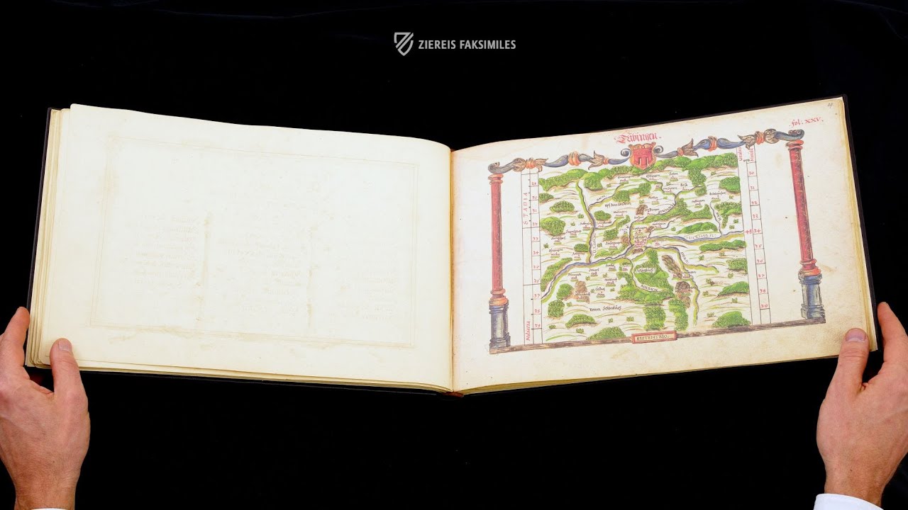
The Entire Duchy of Wuerttemberg
The government of Wuerttemberg commissioned a detailed survey of the land and its topography in the second half of the 16th century. Heinrich Schweickher, the first cartographer, was involved and completed the task. He was predestined to create a topographical survey of Wuerttemberg because of his many travels through the land in the course of his various offices. In 1575 he finally published a collection of 52 maps of the different offices and administrative districts of the duchy, which he dedicated to Duke Louis of Wuerttemberg. In addition to maps of the individual clerical and temporal districts of Wuerttemberg, ordered in offices of Northern and Southern Wuerttemberg, the atlas contained a dedication page with a portrait of the duke, a register of streams and rivers, and a large scale general map.
An Artfully Pioneering Work of Cartography
Schweickher’s maps – unlike what is customary today – are not north-oriented, instead they are south-oriented. As a consequence, West is aligned on the right side and East on the left side of the maps. The cartographic depiction of the various districts of the Duchy followed detailed perspectives, mostly at a scale of 1:125,000. Localities big and small, cities, hamlets, rivers, and forests were diligently recorded and furnished with additional information. Yet the maps are not only interesting topographically, but also offer a visual treat for the eyes in their colorfulness and artistic design. Furnished with architectural and ornamental decorative frames adorned with the corresponding heraldry, the maps are more than mere guidelines. The charts themselves were drawn in powerful colors with a skilled hand, with artistic depictions of forests and villages, for example. Schweickher primarily concerned himself with the main localities under the rule of Wuerttemberg and completely left out the others, like some of the imperial cities. However, in its otherwise indisputable comprehensiveness, today the atlas is still an important source for the history of the former duchy, showing the land before the 30 Years’ War and its devastation, which changed the image of Wuerttemburg for a long time.
Codicology
- Alternative Titles
- Heinrich Schweickher: Atlas von Württemberg 1575
- Type
- Manuscript on paper
- Size / Format
- 96 pages / 39.0 × 26.5 cm
- Origin
- Germany
- Date
- 1575
- Epochs
- Style
- Genre
- Language
- Illustrations
- 55 colored tables and maps
- Artist / School
- Heinrich Schweickher (1526–1579)
")
Heinrich Schweickher: Atlas Of Wuerttemberg 1575
Author Portrait
Dressed in the Spanish style with ruffled cuffs and collar, a black coat trimmed in cloth of gold, a feathered hat, and an elegant shirt, Heinrich Schweickher is shown here holding a pair of gloves in one hand while the other grips the hilt of a sword, a necessary tool for defending himself in his occupation as a travelling royal official. As a result of his extensive travel through the territory, Schweickher acquired the geographical knowledge to create this detailed collection of maps.
")
Heinrich Schweickher: Atlas Of Wuerttemberg 1575
Stuttgart and its Surroundings
Stuttgart has enjoyed a long history as the largest and most important city in the region of modern Baden-Württemberg, which is attested to by this over 400-year-old map. With its characteristic bucking stallion coat of arms at the top, the map shows the red-tile roofs of the city amid the hilly and heavily forested landscape of the region, which has changed remarkably little over the centuries.
The Neckar River is shown flowing to the west of the city, which is a major tributary of the Rhine. It was Stuttgart’s location on this important trading route, in combination with the rich agriculture of the region, that traditionally accounted for its prosperity. The map is framed by two classical columns artfully painted in watercolors.
")
#1 Atlas von Württemberg 1575
Language: German
(under 1,000€)
")
")

")
")
- Treatises / Secular Books
- Apocalypses / Beatus
- Astronomy / Astrology
- Bestiaries
- Bibles / Gospels
- Chronicles / History / Law
- Geography / Maps
- Saints' Lives
- Islam / Oriental
- Judaism / Hebrew
- Single Leaf Collections
- Leonardo da Vinci
- Literature / Poetry
- Liturgical Manuscripts
- Medicine / Botany / Alchemy
- Music
- Mythology / Prophecies
- Psalters
- Other Religious Books
- Games / Hunting
- Private Devotion Books
- Other Genres
- Afghanistan
- Armenia
- Austria
- Belgium
- Belize
- Bosnia and Herzegovina
- China
- Colombia
- Costa Rica
- Croatia
- Cyprus
- Czech Republic
- Denmark
- Egypt
- El Salvador
- Ethiopia
- France
- Germany
- Greece
- Guatemala
- Honduras
- Hungary
- India
- Iran
- Iraq
- Israel
- Italy
- Japan
- Jordan
- Kazakhstan
- Kyrgyzstan
- Lebanon
- Liechtenstein
- Luxembourg
- Mexico
- Morocco
- Netherlands
- Palestine
- Panama
- Peru
- Poland
- Portugal
- Romania
- Russia
- Serbia
- Spain
- Sri Lanka
- Sweden
- Switzerland
- Syria
- Tajikistan
- Turkey
- Turkmenistan
- Ukraine
- United Kingdom
- United States
- Uzbekistan
- Vatican City
- A. Oosthoek, van Holkema & Warendorf
- Aboca Museum
- Ajuntament de Valencia
- Akademie Verlag
- Akademische Druck- u. Verlagsanstalt (ADEVA)
- Aldo Ausilio Editore - Bottega d’Erasmo
- Alecto Historical Editions
- Alkuin Verlag
- Almqvist & Wiksell
- Amilcare Pizzi
- Andreas & Andreas Verlagsbuchhandlung
- Archa 90
- Archiv Verlag
- Archivi Edizioni
- Arnold Verlag
- ARS
- Ars Magna
- Ars Millenii
- Art Market
- ArtCodex
- AyN Ediciones
- Azimuth Editions
- Badenia Verlag
- Bärenreiter-Verlag
- Belser Verlag
- Belser Verlag / WK Wertkontor
- Benziger Verlag
- Bernardinum Wydawnictwo
- BiblioGemma
- Biblioteca Apostolica Vaticana (Vaticanstadt, Vaticanstadt)
- Bibliotheca Palatina Faksimile Verlag
- Bibliotheca Rara
- Boydell & Brewer
- Bramante Edizioni
- Bredius Genootschap
- Brepols Publishers
- British Library
- Brokarte
- C. Weckesser
- Caixa Catalunya
- Canesi
- CAPSA, Ars Scriptoria
- Caratzas Brothers, Publishers
- Carus Verlag
- Casamassima Libri
- Centrum Cartographie Verlag GmbH
- Chavane Verlag
- Christian Brandstätter Verlag
- Circulo Cientifico
- Club Bibliófilo Versol
- Club du Livre
- Club Internacional del Libro
- CM Editores
- Collegium Graphicum
- Collezione Apocrifa Da Vinci
- Comissão Nacional para as Comemorações dos Descobrimentos Portugueses
- Coron Verlag
- Corvina
- CTHS
- D. S. Brewer
- Damon
- De Agostini/UTET
- De Nederlandsche Boekhandel
- De Schutter
- Deuschle & Stemmle
- Deutscher Verlag für Kunstwissenschaft
- DIAMM
- Dropmore Press
- Droz
- E. Schreiber Graphische Kunstanstalten
- Ediciones Boreal
- Ediciones Grial
- Ediclube
- Edições Inapa
- Edilan
- Editalia
- Edition Deuschle
- Edition Georg Popp
- Edition Leipzig
- Edition Libri Illustri
- Editiones Reales Sitios S. L.
- Éditions de l'Oiseau Lyre
- Editions Medicina Rara
- Editorial Casariego
- Editorial Mintzoa
- Editrice Antenore
- Editrice Velar
- Edizioni Edison
- Egeria, S.L.
- Eikon Editores
- Electa
- Emery Walker Limited
- Enciclopèdia Catalana
- Eos-Verlag
- Ephesus Publishing
- Ernst Battenberg
- Eugrammia Press
- Extraordinary Editions
- Fackelverlag
- Facsimila Art & Edition
- Facsimile Editions Ltd.
- Facsimilia Art & Edition Ebert KG
- Faksimile Verlag
- Feuermann Verlag
- Folger Shakespeare Library
- Franco Cosimo Panini Editore
- Friedrich Wittig Verlag
- Fundación Hullera Vasco-Leonesa
- G. Braziller
- Gabriele Mazzotta Editore
- Gebr. Mann Verlag
- Gesellschaft für graphische Industrie
- Getty Research Institute
- Giovanni Domenico de Rossi
- Giunti Editore
- Goldenmark Librarium
- Graffiti
- Grafica European Center of Fine Arts
- Guido Pressler
- Guillermo Blazquez
- Gustav Kiepenheuer
- H. N. Abrams
- Harrassowitz
- Harvard University Press
- Helikon
- Hendrickson Publishers
- Henning Oppermann
- Herder Verlag
- Hes & De Graaf Publishers
- Hoepli
- Holbein-Verlag
- Houghton Library
- Hugo Schmidt Verlag
- Hungarian Academy of Sciences
- Idion Verlag
- Il Bulino, edizioni d'arte
- ILte
- Imago
- Insel Verlag
- Insel-Verlag Anton Kippenberger
- Instituto de Estudios Altoaragoneses
- Instituto Nacional de Antropología e Historia
- Introligatornia Budnik Jerzy
- Istituto dell'Enciclopedia Italiana - Treccani
- Istituto Ellenico di Studi Bizantini e Postbizantini
- Istituto Geografico De Agostini
- Istituto Poligrafico e Zecca dello Stato
- Italarte Art Establishments
- Jaca Book
- Jan Thorbecke Verlag
- Johnson Reprint Corporation
- Johnson Reprint Corporation
- Jos. Baer
- Josef Stocker
- Josef Stocker-Schmid
- Jugoslavija
- Karl W. Hiersemann
- Kasper Straube
- Kaydeda Ediciones
- Kindler Verlag / Coron Verlag
- Kodansha International Ltd.
- Konrad Kölbl Verlag
- Kurt Wolff Verlag
- La Liberia dello Stato
- La Linea Editrice
- La Meta Editore
- Lambert Schneider
- Landeskreditbank Baden-Württemberg
- Leo S. Olschki
- Les Incunables
- Liber Artis
- Library of Congress
- Libreria Musicale Italiana
- Lichtdruck
- Lito Immagine Editore
- Lumen Artis
- Lund Humphries
- M. Moleiro Editor
- Maison des Sciences de l'homme et de la société de Poitiers
- Manuscriptum
- Martinus Nijhoff
- Maruzen-Yushodo Co. Ltd.
- MASA
- Massada Publishers
- McGraw-Hill
- Metropolitan Museum of Art
- Militos
- Millennium Liber
- Müller & Schindler
- Nahar - Stavit
- Nahar and Steimatzky
- National Library of Wales
- Neri Pozza
- Nova Charta
- Oceanum Verlag
- Odeon
- Omnia Arte
- Orbis Mediaevalis
- Orbis Pictus
- Österreichische Staatsdruckerei
- Oxford University Press
- Pageant Books
- Parzellers Buchverlag
- Patrimonio Ediciones
- Pattloch Verlag
- PIAF
- Pieper Verlag
- Plon-Nourrit et cie
- Poligrafiche Bolis
- Presses Universitaires de Strasbourg
- Prestel Verlag
- Princeton University Press
- Prisma Verlag
- Priuli & Verlucca, editori
- Pro Sport Verlag
- Propyläen Verlag
- Pytheas Books
- Quaternio Verlag Luzern
- Reales Sitios
- Recht-Verlag
- Reichert Verlag
- Reichsdruckerei
- Reprint Verlag
- Riehn & Reusch
- Roberto Vattori Editore
- Rosenkilde and Bagger
- Roxburghe Club
- Salerno Editrice
- Saltellus Press
- Sandoz
- Sarajevo Svjetlost
- Schöck ArtPrint Kft.
- Schulsinger Brothers
- Scolar Press
- Scrinium
- Scripta Maneant
- Scriptorium
- Shazar
- Siloé, arte y bibliofilia
- SISMEL - Edizioni del Galluzzo
- Sociedad Mexicana de Antropología
- Société des Bibliophiles & Iconophiles de Belgique
- Soncin Publishing
- Sorli Ediciones
- Stainer and Bell
- Studer
- Styria Verlag
- Sumptibus Pragopress
- Szegedi Tudomànyegyetem
- Taberna Libraria
- Tarshish Books
- Taschen
- Tempus Libri
- Testimonio Compañía Editorial
- TGB Limited Editions
- Thames and Hudson
- The Clear Vue Publishing Partnership Limited
- The Facsimile Codex
- The Folio Society
- The Marquess of Normanby
- The Orphan Hospital Ward of Israel
- The Richard III and Yorkist History Trust
- The Warburg Institute
- Tip.Le.Co
- TouchArt
- TREC Publishing House
- TRI Publishing Co.
- Trident Editore
- Tuliba Collection
- Typis Regiae Officinae Polygraphicae
- Union Verlag Berlin
- Universidad de Granada
- Universitaire Bibliotheken Leiden
- University of California Press
- University of Chicago Press
- Urs Graf
- Vallecchi
- Van Wijnen
- VCH, Acta Humaniora
- VDI Verlag
- VEB Deutscher Verlag für Musik
- Verein Schweizerischer Lithographie-Besitzer
- Verlag Anton Pustet / Andreas Verlag
- Verlag Bibliophile Drucke Josef Stocker
- Verlag der Münchner Drucke
- Verlag für Regionalgeschichte
- Verlag Styria
- Vicent Garcia Editores
- W. Turnowsky
- Waanders Printers
- Wiener Mechitharisten-Congregation (Wien, Österreich)
- Wissenschaftliche Buchgesellschaft
- Wissenschaftliche Verlagsgesellschaft
- Wydawnictwo Dolnoslaskie
- Xuntanza Editorial
- Zakład Narodowy
- Zollikofer AG