Maps of the Captaincy-General of Guatemala
")
Guatemala (?) — 1716–1781
Spanish settlements, proposed fortifications, rivers and mountains: three historical maps of the Spanish colonies of Nicaragua, Costa Rica and Panama as evidence of the progress of colonization in the 18th century
This compendium presents the Spanish colonies in Central America in the 18th century
A historic overview of the modern Central American states of Nicaragua, Costa Rica, and Panama
Settlements, planned forts, lagoons, rivers, mountains, and palm trees are all depicted in detail
Maps of the Captaincy-General of Guatemala

")
")
")
")
")
")
")
")
")
")
")
")
")
")
")
")
(under 1,000€)
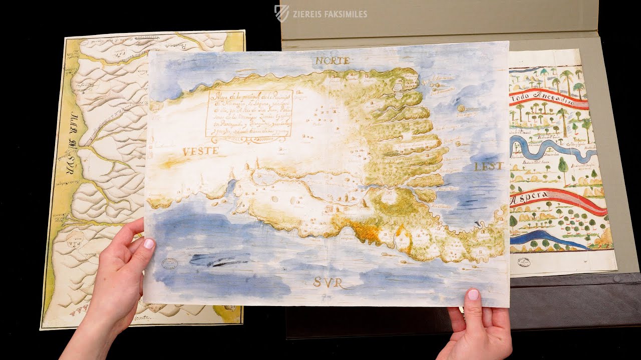
This intriguing compendium of three historical maps present the spirit of the Spanish colonizers in Central America in the 18th century. A sheet from 1716 presents the province of Nicaragua in a marvelous watercolor pen drawing. The second map from the year 1738 shows the course of the Rio Matina, one of the most powerful rivers in the center of Costa Rica, in an unusual format. Finally, the third map presents the provinces around the Cordillera de Talamanca, in modern Costa Rica and Panama, in a depiction from 1781. A marvelous overview of the Central American region that consists of Nicaragua, Costa Rica, and Panama, which invites historical study.
Maps of the Captaincy-General of Guatemala
The three closely related yet completely different maps of Central America give an exciting glimpse into the development of the Spanish colonies in the 18th century. The 1716 depiction of the province of Nicaragua (MP-Guatemala 17) presents a part of the modern Central American country. The “lagoons and rivers” of the province are presented, and so modern Lake Nicaragua, from which the Rio San Juan flows into the Caribbean. The region was mainly settled by the indigenous Miskito and enslaved Africans and belongs to the coastal strip now known as the Miskito Coast, which later became an English protectorate. At the time the map was created, the local population was already collaborating with the English to free themselves from Spanish colonial rule. However, the English crown was primarily concerned with expanding its own colonial supremacy. The watercolor pen-and-ink drawing is a testament to these tensions and was created by Sebastián de Arancibia y Sasi, the Spanish governor of Nicaragua at the time. It is a fine drawing by a skilled hand, beautifully painted in watercolors in shades of blue and green.
Rivers in Costa Rica
The second piece in the compendium is a map showing the course of the Rio Matina from 1738. It presents the course of the river and its mouth in a depiction that includes the surrounding regions and the coast. The Rio Matina is a river in the center of Costa Rica, which borders Nicaragua to the north and Panama to the south. The colorful map is particularly captivating due to its magnificent depiction of countless green trees and palms, blue rivers, and two schematic mountain chains. The map was extended to the unusually long format of 35 × 65 cm due to a ground plan for a fort to be built at the mouth of the river. Thus, the map is not only an artistic geographical representation of the region, but also testifies to the Spanish efforts to consolidate their colonial rule.
A Central American Mountain Range
The third map presents the provinces around Cordillera de Talamanca, Costa Rica's largest and highest mountain chain. Created in 1781 by surveyor Josef de Rivera Gálvez, the map shows a subtly colored geographical representation of the mountains and occasionally indicates settlements and rivers. The bordering sea is depicted geographically correctly to the left and right of the landmass, the mar del norte and the mar al sur respectively, but it is actually the Pacific and Caribbean that border the land to the west and east.
Geographic Voyages of Discovery
The three maps from the 18th century, which are housed today in the Archivo General de Indias in Seville, give a wonderful overview of this region of today's Central American states of Nicaragua, Costa Rica, and Panama. They bear witness to the progress and intertwining of Spanish and English colonization in the 18th century, but also to the resistance of the colonized and enslaved. Studying them provides fascinating insights into this formative period in Central American history.
Codicology
- Alternative Titles
- Mapa de Costa Rica
Costa Rica testimonios gráficos
Testimonios gráficos de su etapa colonial existentes en el Archivo General de Indias
Costa Rica, Indies General Archive graphical testimonies of its Colonial Stage
Karte von Costa Rica
Costa Rica Map
Plano del curso del río de Matina y su desembocadura, con la porción de la costa y tierras situadas entre los ríos Moin y Pacuari - Type
- Map on paper
- Size / Format
- 3 maps / 31.0 × 43.0 cm / 36.5 × 84.7 cm / 48.0 × 30.0 cm
- Origin
- Guatemala
- Date
- 1716–1781
- Epochs
- Style
- Genre
- Language
- Script
- Secretary
- Illustrations
- 3 Maps: Drawings of the Province of Nicaragua (1716), Rio Matina (1738–55), and Province of Telemanca (1781)
- Artist / School
- Sebastián de Arancibia y Sasi (illuminator)
Josef de Rivera Gálvez (illuminator)
")
Maps of the Captaincy-General of Guatemala
Cordillera de Talamanca
Stretching from Costa Rica to Panama, the Cordillera de Talamanca is a forest-covered mountain range, much of which remains unexplored today. This wonderful map from 1781 shows the various settlements (many of which are labelled) and rivers that crisscrossed the region. The artist has skillfully shaded the map to demonstrate the various ridges and features of the mountain range. Tributaries wind their way through the mountains, joining one another and emptying into the Pacific Ocean.
")
Maps of the Captaincy-General of Guatemala
Rivers of Costa Rica
This large map shows the course of the mighty Rio Martina flanked by two other rivers draining into the Caribbean, identified here as the Mare del Norte. Two mountain ranges are labelled with banderoles and one side of the river is covered with palms, while the other has leafy trees, all of which are depicted in detail on the right where the tributaries converge.
The map was extended to include a ground plan for a fort – complete with cannons establishing fields of fire around the fort – to be built at the mouth of the river. Marked by a red flag with a white “X”, the proposed fort is depicted guarding the mouth of the river, where several islands are labelled. The map has survived in remarkably good condition with almost no marks or blemishes.
")
#1 Mapa de Costa Rica
Language: Spanish
The commentary volume features a descriptive study by the Section Chief of the General Archive of the Indie.
(under 1,000€)
")
")
")
")
")
")
- Treatises / Secular Books
- Apocalypses / Beatus
- Astronomy / Astrology
- Bestiaries
- Bibles / Gospels
- Chronicles / History / Law
- Geography / Maps
- Saints' Lives
- Islam / Oriental
- Judaism / Hebrew
- Single Leaf Collections
- Leonardo da Vinci
- Literature / Poetry
- Liturgical Manuscripts
- Medicine / Botany / Alchemy
- Music
- Mythology / Prophecies
- Psalters
- Other Religious Books
- Games / Hunting
- Private Devotion Books
- Other Genres
- Afghanistan
- Armenia
- Austria
- Belgium
- Belize
- Bosnia and Herzegovina
- China
- Colombia
- Costa Rica
- Croatia
- Cyprus
- Czech Republic
- Denmark
- Egypt
- El Salvador
- Ethiopia
- France
- Germany
- Greece
- Guatemala
- Honduras
- Hungary
- India
- Iran
- Iraq
- Israel
- Italy
- Japan
- Jordan
- Kazakhstan
- Kyrgyzstan
- Lebanon
- Liechtenstein
- Luxembourg
- Mexico
- Morocco
- Netherlands
- Palestine
- Panama
- Peru
- Poland
- Portugal
- Romania
- Russia
- Serbia
- Spain
- Sri Lanka
- Sweden
- Switzerland
- Syria
- Tajikistan
- Turkey
- Turkmenistan
- Ukraine
- United Kingdom
- United States
- Uzbekistan
- Vatican City
- A. Oosthoek, van Holkema & Warendorf
- Aboca Museum
- Ajuntament de Valencia
- Akademie Verlag
- Akademische Druck- u. Verlagsanstalt (ADEVA)
- Aldo Ausilio Editore - Bottega d’Erasmo
- Alecto Historical Editions
- Alkuin Verlag
- Almqvist & Wiksell
- Amilcare Pizzi
- Andreas & Andreas Verlagsbuchhandlung
- Archa 90
- Archiv Verlag
- Archivi Edizioni
- Arnold Verlag
- ARS
- Ars Magna
- Ars Millenii
- Art Market
- ArtCodex
- AyN Ediciones
- Azimuth Editions
- Badenia Verlag
- Bärenreiter-Verlag
- Belser Verlag
- Belser Verlag / WK Wertkontor
- Benziger Verlag
- Bernardinum Wydawnictwo
- BiblioGemma
- Biblioteca Apostolica Vaticana (Vaticanstadt, Vaticanstadt)
- Bibliotheca Palatina Faksimile Verlag
- Bibliotheca Rara
- Boydell & Brewer
- Bramante Edizioni
- Bredius Genootschap
- Brepols Publishers
- British Library
- Brokarte
- C. Weckesser
- Caixa Catalunya
- Canesi
- CAPSA, Ars Scriptoria
- Caratzas Brothers, Publishers
- Carus Verlag
- Casamassima Libri
- Centrum Cartographie Verlag GmbH
- Chavane Verlag
- Christian Brandstätter Verlag
- Circulo Cientifico
- Club Bibliófilo Versol
- Club du Livre
- Club Internacional del Libro
- CM Editores
- Collegium Graphicum
- Collezione Apocrifa Da Vinci
- Comissão Nacional para as Comemorações dos Descobrimentos Portugueses
- Coron Verlag
- Corvina
- CTHS
- D. S. Brewer
- Damon
- De Agostini/UTET
- De Nederlandsche Boekhandel
- De Schutter
- Deuschle & Stemmle
- Deutscher Verlag für Kunstwissenschaft
- DIAMM
- Dropmore Press
- Droz
- E. Schreiber Graphische Kunstanstalten
- Ediciones Boreal
- Ediciones Grial
- Ediclube
- Edições Inapa
- Edilan
- Editalia
- Edition Deuschle
- Edition Georg Popp
- Edition Leipzig
- Edition Libri Illustri
- Editiones Reales Sitios S. L.
- Éditions de l'Oiseau Lyre
- Editions Medicina Rara
- Editorial Casariego
- Editorial Mintzoa
- Editrice Antenore
- Editrice Velar
- Edizioni Edison
- Egeria, S.L.
- Eikon Editores
- Electa
- Emery Walker Limited
- Enciclopèdia Catalana
- Eos-Verlag
- Ephesus Publishing
- Ernst Battenberg
- Eugrammia Press
- Extraordinary Editions
- Fackelverlag
- Facsimila Art & Edition
- Facsimile Editions Ltd.
- Facsimilia Art & Edition Ebert KG
- Faksimile Verlag
- Feuermann Verlag
- Folger Shakespeare Library
- Franco Cosimo Panini Editore
- Friedrich Wittig Verlag
- Fundación Hullera Vasco-Leonesa
- G. Braziller
- Gabriele Mazzotta Editore
- Gebr. Mann Verlag
- Gesellschaft für graphische Industrie
- Getty Research Institute
- Giovanni Domenico de Rossi
- Giunti Editore
- Goldenmark Librarium
- Graffiti
- Grafica European Center of Fine Arts
- Guido Pressler
- Guillermo Blazquez
- Gustav Kiepenheuer
- H. N. Abrams
- Harrassowitz
- Harvard University Press
- Helikon
- Hendrickson Publishers
- Henning Oppermann
- Herder Verlag
- Hes & De Graaf Publishers
- Hoepli
- Holbein-Verlag
- Houghton Library
- Hugo Schmidt Verlag
- Hungarian Academy of Sciences
- Idion Verlag
- Il Bulino, edizioni d'arte
- ILte
- Imago
- Insel Verlag
- Insel-Verlag Anton Kippenberger
- Instituto de Estudios Altoaragoneses
- Instituto Nacional de Antropología e Historia
- Introligatornia Budnik Jerzy
- Istituto dell'Enciclopedia Italiana - Treccani
- Istituto Ellenico di Studi Bizantini e Postbizantini
- Istituto Geografico De Agostini
- Istituto Poligrafico e Zecca dello Stato
- Italarte Art Establishments
- Jaca Book
- Jan Thorbecke Verlag
- Johnson Reprint Corporation
- Johnson Reprint Corporation
- Jos. Baer
- Josef Stocker
- Josef Stocker-Schmid
- Jugoslavija
- Karl W. Hiersemann
- Kasper Straube
- Kaydeda Ediciones
- Kindler Verlag / Coron Verlag
- Kodansha International Ltd.
- Konrad Kölbl Verlag
- Kurt Wolff Verlag
- La Liberia dello Stato
- La Linea Editrice
- La Meta Editore
- Lambert Schneider
- Landeskreditbank Baden-Württemberg
- Leo S. Olschki
- Les Incunables
- Liber Artis
- Library of Congress
- Libreria Musicale Italiana
- Lichtdruck
- Lito Immagine Editore
- Lumen Artis
- Lund Humphries
- M. Moleiro Editor
- Maison des Sciences de l'homme et de la société de Poitiers
- Manuscriptum
- Martinus Nijhoff
- Maruzen-Yushodo Co. Ltd.
- MASA
- Massada Publishers
- McGraw-Hill
- Metropolitan Museum of Art
- Militos
- Millennium Liber
- Müller & Schindler
- Nahar - Stavit
- Nahar and Steimatzky
- National Library of Wales
- Neri Pozza
- Nova Charta
- Oceanum Verlag
- Odeon
- Omnia Arte
- Orbis Mediaevalis
- Orbis Pictus
- Österreichische Staatsdruckerei
- Oxford University Press
- Pageant Books
- Parzellers Buchverlag
- Patrimonio Ediciones
- Pattloch Verlag
- PIAF
- Pieper Verlag
- Plon-Nourrit et cie
- Poligrafiche Bolis
- Presses Universitaires de Strasbourg
- Prestel Verlag
- Princeton University Press
- Prisma Verlag
- Priuli & Verlucca, editori
- Pro Sport Verlag
- Propyläen Verlag
- Pytheas Books
- Quaternio Verlag Luzern
- Reales Sitios
- Recht-Verlag
- Reichert Verlag
- Reichsdruckerei
- Reprint Verlag
- Riehn & Reusch
- Roberto Vattori Editore
- Rosenkilde and Bagger
- Roxburghe Club
- Salerno Editrice
- Saltellus Press
- Sandoz
- Sarajevo Svjetlost
- Schöck ArtPrint Kft.
- Schulsinger Brothers
- Scolar Press
- Scrinium
- Scripta Maneant
- Scriptorium
- Shazar
- Siloé, arte y bibliofilia
- SISMEL - Edizioni del Galluzzo
- Sociedad Mexicana de Antropología
- Société des Bibliophiles & Iconophiles de Belgique
- Soncin Publishing
- Sorli Ediciones
- Stainer and Bell
- Studer
- Styria Verlag
- Sumptibus Pragopress
- Szegedi Tudomànyegyetem
- Taberna Libraria
- Tarshish Books
- Taschen
- Tempus Libri
- Testimonio Compañía Editorial
- TGB Limited Editions
- Thames and Hudson
- The Clear Vue Publishing Partnership Limited
- The Facsimile Codex
- The Folio Society
- The Marquess of Normanby
- The Orphan Hospital Ward of Israel
- The Richard III and Yorkist History Trust
- The Warburg Institute
- Tip.Le.Co
- TouchArt
- TREC Publishing House
- TRI Publishing Co.
- Trident Editore
- Tuliba Collection
- Typis Regiae Officinae Polygraphicae
- Union Verlag Berlin
- Universidad de Granada
- Universitaire Bibliotheken Leiden
- University of California Press
- University of Chicago Press
- Urs Graf
- Vallecchi
- Van Wijnen
- VCH, Acta Humaniora
- VDI Verlag
- VEB Deutscher Verlag für Musik
- Verein Schweizerischer Lithographie-Besitzer
- Verlag Anton Pustet / Andreas Verlag
- Verlag Bibliophile Drucke Josef Stocker
- Verlag der Münchner Drucke
- Verlag für Regionalgeschichte
- Verlag Styria
- Vicent Garcia Editores
- W. Turnowsky
- Waanders Printers
- Wiener Mechitharisten-Congregation (Wien, Österreich)
- Wissenschaftliche Buchgesellschaft
- Wissenschaftliche Verlagsgesellschaft
- Wydawnictwo Dolnoslaskie
- Xuntanza Editorial
- Zakład Narodowy
- Zollikofer AG