Tabula Peutingeriana
 – Cod. Vindob. 324 – Österreichische Nationalbibliothek (Vienna, Austria)")
Monastery of Reichenau (Germany) — 12th/13th century
Almost like a modern travel guide: the only surviving copy of an ancient map of the Roman road network, peppered with practical information on places and accommodations in the vast Imperium Romanum
A graphical representation of the most important roads running through the Roman Empire
The original 4th century manuscript was copied in either the 12th or 13th centuries as is reflected in the artwork
It also reports on the comfort to be expected at various stopovers like in modern travel guides
Tabula Peutingeriana

 – Cod. Vindob. 324 – Österreichische Nationalbibliothek (Vienna, Austria)")
 – Cod. Vindob. 324 – Österreichische Nationalbibliothek (Vienna, Austria)")
 – Cod. Vindob. 324 – Österreichische Nationalbibliothek (Vienna, Austria)")
 – Cod. Vindob. 324 – Österreichische Nationalbibliothek (Vienna, Austria)")
 – Cod. Vindob. 324 – Österreichische Nationalbibliothek (Vienna, Austria)")
 – Cod. Vindob. 324 – Österreichische Nationalbibliothek (Vienna, Austria)")
 – Cod. Vindob. 324 – Österreichische Nationalbibliothek (Vienna, Austria)")
 – Cod. Vindob. 324 – Österreichische Nationalbibliothek (Vienna, Austria)")
 – Cod. Vindob. 324 – Österreichische Nationalbibliothek (Vienna, Austria)")
 – Cod. Vindob. 324 – Österreichische Nationalbibliothek (Vienna, Austria)")
 – Cod. Vindob. 324 – Österreichische Nationalbibliothek (Vienna, Austria)")
 – Cod. Vindob. 324 – Österreichische Nationalbibliothek (Vienna, Austria)")
 – Cod. Vindob. 324 – Österreichische Nationalbibliothek (Vienna, Austria)")
 – Cod. Vindob. 324 – Österreichische Nationalbibliothek (Vienna, Austria)")
 – Cod. Vindob. 324 – Österreichische Nationalbibliothek (Vienna, Austria)")
 – Cod. Vindob. 324 – Österreichische Nationalbibliothek (Vienna, Austria)")
 – Cod. Vindob. 324 – Österreichische Nationalbibliothek (Vienna, Austria)")
 – Cod. Vindob. 324 – Österreichische Nationalbibliothek (Vienna, Austria)")
 – Cod. Vindob. 324 – Österreichische Nationalbibliothek (Vienna, Austria)")
 – Cod. Vindob. 324 – Österreichische Nationalbibliothek (Vienna, Austria)")
 – Cod. Vindob. 324 – Österreichische Nationalbibliothek (Vienna, Austria)")
 – Cod. Vindob. 324 – Österreichische Nationalbibliothek (Vienna, Austria)")
(under 1,000€)
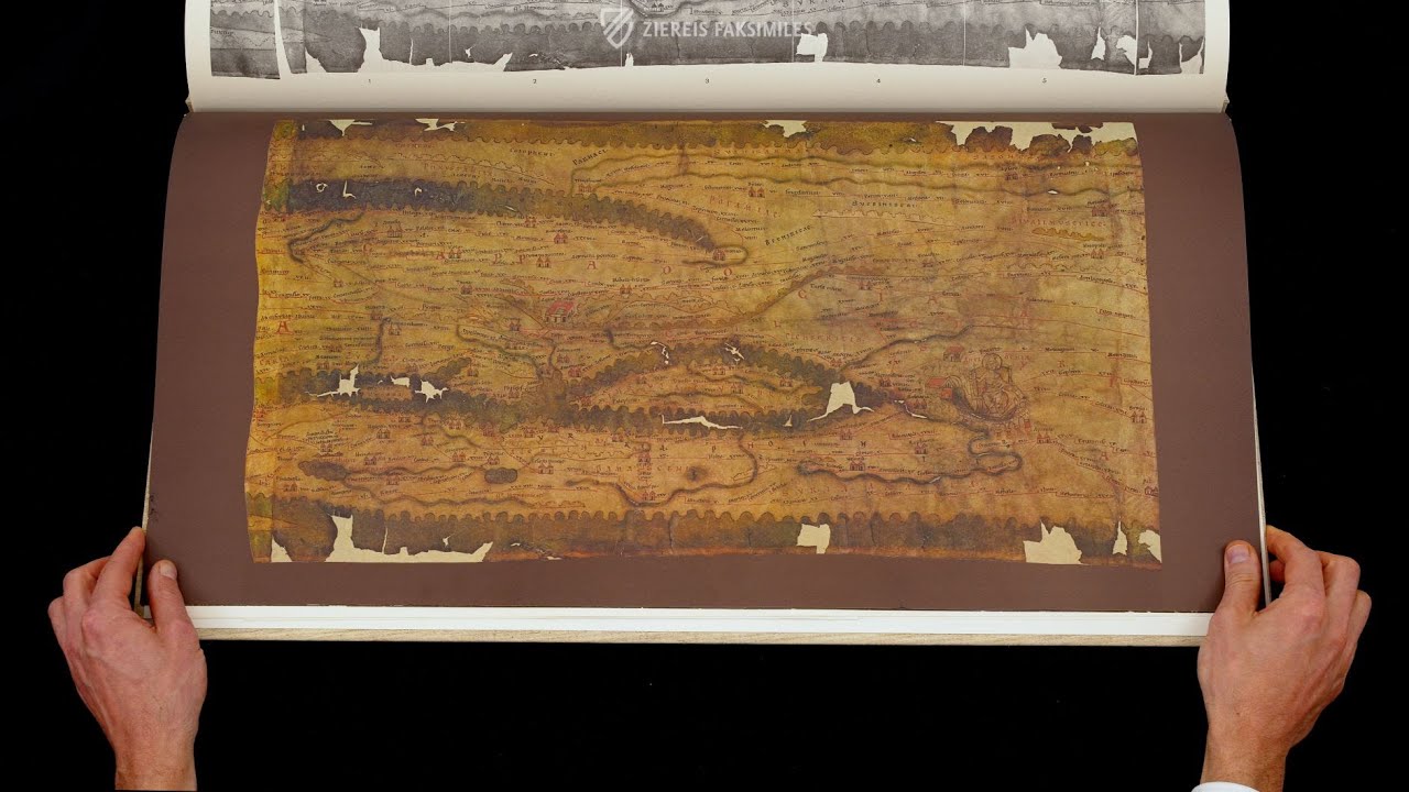
More than merely being great warriors, the Romans were some of the greatest engineers, merchants, and bureaucrats of antiquity. Rome was a massive mercantile machine, commerce was the blood that sustained it and its circulatory system was the system of roads that allowed the swift and reliable transport of goods and people, be they merchants or legionaries. The Tabula Peutingeriana contains a graphical representation of the most important roads and lines of traffic running through the Roman Empire, as well as information on towns and places of lodging. The original 4th century manuscript was copied in either the 12th or 13th centuries as is reflected in the artwork. It is of priceless value today, particularly since it is the only example of its kind which has come down to us from antiquity, and as such is one of the most prized items in the illustrious collections of the Austrian National Library.
Tabula Peutingeriana
The map named after its former owner Konrad Peutinger is a great document of cultural history, as it constitutes the only surviving testimony to an antique Roman map of the world. Rather than being a geographical illustration, it contains a graphical representation of the most important roads and lines of traffic running through the Roman Empire. The manuscript consists of eleven parchment leaves which were originally glued together along their edges to form a roll. This roll was 6.75 m long and a little less than 34 cm wide. The Tabula Peutingeriana contains the road network of the then known world, more precisely – considering that the first section is now lost – from Spain, England, France, through to the European area south of the Danube, all the way to northern Africa, the Near and Middle East and finally across to Peninsular India and Ceylon. The Tabula Peutingeriana was modeled after an antique world map dating back to the 4th century**. This Roman original was copied in the 12th or 13th century by a monk in southern Germany, perhaps at Reichenau abbey. It is of priceless value today, particularly since it is the only example of its kind which has come down to us from antiquity. After having changed owners several times, it passed into the ownership of Prince Eugene, whose precious library was later integrated into the stocks of the Austrian National Library where the Tabula Peutingeriana is still kept today as one of the greatest treasures.
An Antique Road Map
The Tabula Peutingeriana depicts the most important travel routes of the Imperium Romanum, providing an overview of the empire’s roads and routes used by travelers and merchants, but also by state officials, from the simple soldier to the general or provincial governor on official trips. It thus constituted a map for practical use, which not only indicated locations and distances but also hostels and inns. Of particular interest is the detailed identification of numerous towns, 555 in all, with so-called vignettes, ranging from twin towers and spas to temples, ports, lighthouses and even a road tunnel, through to the personification of the goddesses of the three most important cities: Rome, Constantinople and Antioch. Rather than reflecting the character of a town, these vignettes are intended to indicate the location’s size and available accommodations. This is in line with the purpose of this map which intends to be a kind of traveler’s manual, going beyond the representation of roads and distances, giving a general report of the comfort to be expected at the various stopovers, just like in modern travel guides where the character of hostels and hotels is identified with stars or other symbols.
All Roads Lead to Rome
In the middle of a circle, from which the largest roads of Italy emanate like the rays of the sun – thus embodying the symbol of eternal Rome reigning above the other cities – the goddess Dea Roma is seated on an elevated throne, scepter and orb in her hands and a crown on her head. She represents the pagan Dea Roma restyled into the figure of a medieval Roman-German Emperor. The medieval copyist obviously did away with her female attributes (one can, however, see traces of a right breast) and replaced Dea Roma’s helmet with an imperial crown.
Codicology
- Alternative Titles
- Peutinger table
Peutinger map - Type
- Map on parchment
- Size / Format
- 1 map / 675.0 × 34.0 cm
- Origin
- Germany
- Date
- 12th/13th century
- Style
- Genre
- Language
- Script
- Gothic Textura Rotunda
- Content
- Road map of the Roman Empire
- Previous Owners
- Konrad Celtes
Konrad Peutinger
Prince Eugene of Austria
 – Cod. Vindob. 324 – Österreichische Nationalbibliothek (Vienna, Austria)")
")
")
Tabula Peutingeriana
Rome
This schematic map emphasizes the preeminence of Rome by showing the emperor crowned and enthroned with a globus in one hand and a scepter in the other and wearing a toga. Roads depicted as straight red lines radiate from the great city labelled with the names of the cities they lead to. At the mouth of the Tiber River, the port of Ostia is depicted as a neat semi-circle guarded by towers. Significant settlements are indicated by buildings with red tiled roofs.
 – Cod. Vindob. 324 – Österreichische Nationalbibliothek (Vienna, Austria)")
Tabula Peutingeriana
Segment 7 – Central Mediterranean
This map is actually part of a larger map of the Roman road system was later divided into twelve parts. It is a depiction of the Central Mediterranean Sea including Sicily and Southern Italy, the mouth of the Adriatic Sea, the western regions Macedonia and Greece, the Tunisian coast of North Africa, as well as detailing various smaller islands.
The Romans were certainly capable of creating geographically accurate maps, but this is a schematic map of the Empire’s road system and specifies the distances between settlements. It was used to plan itineraries along established routes, not for navigation. Nonetheless, relevant geographical features like rivers and mountains are depicted, and more important settlements are represented with buildings.
 – Cod. Vindob. 324 – Österreichische Nationalbibliothek (Vienna, Austria)")
#1 Tabula Peutingeriana
Language: German
The valuable scholarly commentary by Ekkehard Weber describes the contents of the map, its original quality and the story of its discovery and exploration. A comprehensive bibliography and a complete register of the towns and stops indicated makes this outstanding edition accessible to both the expert and the amateur alike.
E. Weber, Vienna. 68 pp. with 8 ill. and 26 pp. index, several modern maps. Binding: stitched.
(under 1,000€)
#2 La Tabula Peutingeriana
")
Language: Italian
(under 1,000€)
#3 Tabula Peutingeriana. Le antiche vie del mondo
")
Language: Italian
(under 1,000€)
")

")
")
")
")

- Treatises / Secular Books
- Apocalypses / Beatus
- Astronomy / Astrology
- Bestiaries
- Bibles / Gospels
- Chronicles / History / Law
- Geography / Maps
- Saints' Lives
- Islam / Oriental
- Judaism / Hebrew
- Single Leaf Collections
- Leonardo da Vinci
- Literature / Poetry
- Liturgical Manuscripts
- Medicine / Botany / Alchemy
- Music
- Mythology / Prophecies
- Psalters
- Other Religious Books
- Games / Hunting
- Private Devotion Books
- Other Genres
- Afghanistan
- Armenia
- Austria
- Belgium
- Belize
- Bosnia and Herzegovina
- China
- Colombia
- Costa Rica
- Croatia
- Cyprus
- Czech Republic
- Denmark
- Egypt
- El Salvador
- Ethiopia
- France
- Germany
- Greece
- Guatemala
- Honduras
- Hungary
- India
- Iran
- Iraq
- Israel
- Italy
- Japan
- Jordan
- Kazakhstan
- Kyrgyzstan
- Lebanon
- Liechtenstein
- Luxembourg
- Mexico
- Morocco
- Netherlands
- Palestine
- Panama
- Peru
- Poland
- Portugal
- Romania
- Russia
- Serbia
- Spain
- Sri Lanka
- Sweden
- Switzerland
- Syria
- Tajikistan
- Turkey
- Turkmenistan
- Ukraine
- United Kingdom
- United States
- Uzbekistan
- Vatican City
- A. Oosthoek, van Holkema & Warendorf
- Aboca Museum
- Ajuntament de Valencia
- Akademie Verlag
- Akademische Druck- u. Verlagsanstalt (ADEVA)
- Aldo Ausilio Editore - Bottega d’Erasmo
- Alecto Historical Editions
- Alkuin Verlag
- Almqvist & Wiksell
- Amilcare Pizzi
- Andreas & Andreas Verlagsbuchhandlung
- Archa 90
- Archiv Verlag
- Archivi Edizioni
- Arnold Verlag
- ARS
- Ars Magna
- Ars Millenii
- Art Market
- ArtCodex
- AyN Ediciones
- Azimuth Editions
- Badenia Verlag
- Bärenreiter-Verlag
- Belser Verlag
- Belser Verlag / WK Wertkontor
- Benziger Verlag
- Bernardinum Wydawnictwo
- BiblioGemma
- Biblioteca Apostolica Vaticana (Vaticanstadt, Vaticanstadt)
- Bibliotheca Palatina Faksimile Verlag
- Bibliotheca Rara
- Boydell & Brewer
- Bramante Edizioni
- Bredius Genootschap
- Brepols Publishers
- British Library
- Brokarte
- C. Weckesser
- Caixa Catalunya
- Canesi
- CAPSA, Ars Scriptoria
- Caratzas Brothers, Publishers
- Carus Verlag
- Casamassima Libri
- Centrum Cartographie Verlag GmbH
- Chavane Verlag
- Christian Brandstätter Verlag
- Circulo Cientifico
- Club Bibliófilo Versol
- Club du Livre
- Club Internacional del Libro
- CM Editores
- Collegium Graphicum
- Collezione Apocrifa Da Vinci
- Comissão Nacional para as Comemorações dos Descobrimentos Portugueses
- Coron Verlag
- Corvina
- CTHS
- D. S. Brewer
- Damon
- De Agostini/UTET
- De Nederlandsche Boekhandel
- De Schutter
- Deuschle & Stemmle
- Deutscher Verlag für Kunstwissenschaft
- DIAMM
- Dropmore Press
- Droz
- E. Schreiber Graphische Kunstanstalten
- Ediciones Boreal
- Ediciones Grial
- Ediclube
- Edições Inapa
- Edilan
- Editalia
- Edition Deuschle
- Edition Georg Popp
- Edition Leipzig
- Edition Libri Illustri
- Editiones Reales Sitios S. L.
- Éditions de l'Oiseau Lyre
- Editions Medicina Rara
- Editorial Casariego
- Editorial Mintzoa
- Editrice Antenore
- Editrice Velar
- Edizioni Edison
- Egeria, S.L.
- Eikon Editores
- Electa
- Emery Walker Limited
- Enciclopèdia Catalana
- Eos-Verlag
- Ephesus Publishing
- Ernst Battenberg
- Eugrammia Press
- Extraordinary Editions
- Fackelverlag
- Facsimila Art & Edition
- Facsimile Editions Ltd.
- Facsimilia Art & Edition Ebert KG
- Faksimile Verlag
- Feuermann Verlag
- Folger Shakespeare Library
- Franco Cosimo Panini Editore
- Friedrich Wittig Verlag
- Fundación Hullera Vasco-Leonesa
- G. Braziller
- Gabriele Mazzotta Editore
- Gebr. Mann Verlag
- Gesellschaft für graphische Industrie
- Getty Research Institute
- Giovanni Domenico de Rossi
- Giunti Editore
- Goldenmark Librarium
- Graffiti
- Grafica European Center of Fine Arts
- Guido Pressler
- Guillermo Blazquez
- Gustav Kiepenheuer
- H. N. Abrams
- Harrassowitz
- Harvard University Press
- Helikon
- Hendrickson Publishers
- Henning Oppermann
- Herder Verlag
- Hes & De Graaf Publishers
- Hoepli
- Holbein-Verlag
- Houghton Library
- Hugo Schmidt Verlag
- Hungarian Academy of Sciences
- Idion Verlag
- Il Bulino, edizioni d'arte
- ILte
- Imago
- Insel Verlag
- Insel-Verlag Anton Kippenberger
- Instituto de Estudios Altoaragoneses
- Instituto Nacional de Antropología e Historia
- Introligatornia Budnik Jerzy
- Istituto dell'Enciclopedia Italiana - Treccani
- Istituto Ellenico di Studi Bizantini e Postbizantini
- Istituto Geografico De Agostini
- Istituto Poligrafico e Zecca dello Stato
- Italarte Art Establishments
- Jaca Book
- Jan Thorbecke Verlag
- Johnson Reprint Corporation
- Johnson Reprint Corporation
- Jos. Baer
- Josef Stocker
- Josef Stocker-Schmid
- Jugoslavija
- Karl W. Hiersemann
- Kasper Straube
- Kaydeda Ediciones
- Kindler Verlag / Coron Verlag
- Kodansha International Ltd.
- Konrad Kölbl Verlag
- Kurt Wolff Verlag
- La Liberia dello Stato
- La Linea Editrice
- La Meta Editore
- Lambert Schneider
- Landeskreditbank Baden-Württemberg
- Leo S. Olschki
- Les Incunables
- Liber Artis
- Library of Congress
- Libreria Musicale Italiana
- Lichtdruck
- Lito Immagine Editore
- Lumen Artis
- Lund Humphries
- M. Moleiro Editor
- Maison des Sciences de l'homme et de la société de Poitiers
- Manuscriptum
- Martinus Nijhoff
- Maruzen-Yushodo Co. Ltd.
- MASA
- Massada Publishers
- McGraw-Hill
- Metropolitan Museum of Art
- Militos
- Millennium Liber
- Müller & Schindler
- Nahar - Stavit
- Nahar and Steimatzky
- National Library of Wales
- Neri Pozza
- Nova Charta
- Oceanum Verlag
- Odeon
- Omnia Arte
- Orbis Mediaevalis
- Orbis Pictus
- Österreichische Staatsdruckerei
- Oxford University Press
- Pageant Books
- Parzellers Buchverlag
- Patrimonio Ediciones
- Pattloch Verlag
- PIAF
- Pieper Verlag
- Plon-Nourrit et cie
- Poligrafiche Bolis
- Presses Universitaires de Strasbourg
- Prestel Verlag
- Princeton University Press
- Prisma Verlag
- Priuli & Verlucca, editori
- Pro Sport Verlag
- Propyläen Verlag
- Pytheas Books
- Quaternio Verlag Luzern
- Reales Sitios
- Recht-Verlag
- Reichert Verlag
- Reichsdruckerei
- Reprint Verlag
- Riehn & Reusch
- Roberto Vattori Editore
- Rosenkilde and Bagger
- Roxburghe Club
- Salerno Editrice
- Saltellus Press
- Sandoz
- Sarajevo Svjetlost
- Schöck ArtPrint Kft.
- Schulsinger Brothers
- Scolar Press
- Scrinium
- Scripta Maneant
- Scriptorium
- Shazar
- Siloé, arte y bibliofilia
- SISMEL - Edizioni del Galluzzo
- Sociedad Mexicana de Antropología
- Société des Bibliophiles & Iconophiles de Belgique
- Soncin Publishing
- Sorli Ediciones
- Stainer and Bell
- Studer
- Styria Verlag
- Sumptibus Pragopress
- Szegedi Tudomànyegyetem
- Taberna Libraria
- Tarshish Books
- Taschen
- Tempus Libri
- Testimonio Compañía Editorial
- TGB Limited Editions
- Thames and Hudson
- The Clear Vue Publishing Partnership Limited
- The Facsimile Codex
- The Folio Society
- The Marquess of Normanby
- The Orphan Hospital Ward of Israel
- The Richard III and Yorkist History Trust
- The Warburg Institute
- Tip.Le.Co
- TouchArt
- TREC Publishing House
- TRI Publishing Co.
- Trident Editore
- Tuliba Collection
- Typis Regiae Officinae Polygraphicae
- Union Verlag Berlin
- Universidad de Granada
- Universitaire Bibliotheken Leiden
- University of California Press
- University of Chicago Press
- Urs Graf
- Vallecchi
- Van Wijnen
- VCH, Acta Humaniora
- VDI Verlag
- VEB Deutscher Verlag für Musik
- Verein Schweizerischer Lithographie-Besitzer
- Verlag Anton Pustet / Andreas Verlag
- Verlag Bibliophile Drucke Josef Stocker
- Verlag der Münchner Drucke
- Verlag für Regionalgeschichte
- Verlag Styria
- Vicent Garcia Editores
- W. Turnowsky
- Waanders Printers
- Wiener Mechitharisten-Congregation (Wien, Österreich)
- Wissenschaftliche Buchgesellschaft
- Wissenschaftliche Verlagsgesellschaft
- Wydawnictwo Dolnoslaskie
- Xuntanza Editorial
- Zakład Narodowy
- Zollikofer AG