Atlas of Pedro de Texeira
")
Spain — 1634
Meticulously researched and detailed maps in vibrant colors: the Spanish Empire at the height of its power depicted on splendid, mostly double-page maps
The 1634 map series of King Philip IV of Spain (1605–65) presents the Spanish Empire in detail and in its full glory
Pedro Texeira (1595–1662) spent the years 1620–22 just mapping the coasts of the Iberian Peninsula
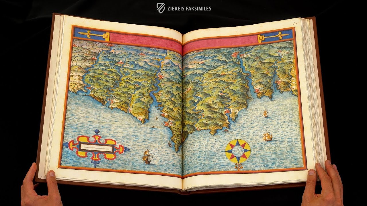
Mostly double-page maps are encircled with wonderful frames and contain a variety of information
Atlas of Pedro de Texeira

")
")
")
")
")
")
")
")
")
")
")
")
")
")
")
")
")
")
")
")
")
")
")
")
")
(3,000€ - 7,000€)
King Philip IV of Spain commissioned a map series from his royal geographer and cartographer Pedro Texeira in 1634. The Descripción de España y de las Costas y Puertos de sus Reynos was meant to present the Spanish Empire in detail and in its full glory. Wonderfully colored and creatively depicted maps give an overview of the coasts and cities of Spain and the Iberian Peninsula. The world map also give a glimpse of the outstanding cartographic findings and abilities of the significant Spanish court geographer.
Atlas of Pedro de Texeira
In 1634, the Spanish King Philip IV commissioned a map series from his royal geographer and cartographer Pedro Texeira. The Descripción de España y de las Costas y Puertos de sus Reynos was to present the great Spanish power in detail and in its full glory. Gorgeously colored and creatively designed maps give an overview of the coasts and cities of Spain and the Iberian Peninsula. However, a world map offers a glimpse of the outstanding cartographical findings and abilities of the important 17th century Spanish court geographer.
Spain’s Glory in Geographic Format
Already at the beginning of the 17th century, Spain could look back on a grandiose history as a great power. Spain stood at the pinnacle of the great powers of Europe at least since Charles I of Spain was elected Holy Roman Emperor Charles V in 1519. This supremacy reached its zenith in the 16th century as Spain forged a global empire from colonies on three continents. The slow loss of this prominence began under Philip IV of Spain (1605–1665), who inter alia undertook many wars against the Netherlands, France, and England among others, and summoned Diego Velázquez to court. Spain’s global empire was to once again enjoy great fame in Pedro Texeira’s atlas.
The “Cosmographer” of Two Kings
This Pedro Texeira (1595–1662) was originally a Portuguese cartographer, who came to Spain ca. 1610. There he enjoyed the highest accolades as the royal “cosmographer”. He was the court geographer and cartographer under Kings Philip III (1598–1621) and Philip IV (1621–1665) of Spain and was consequently known in the highest circles. In the years 1622–20, Texeira was occupied with the mapping of the coasts of the Iberian Peninsula. These geographic findings served as the foundation for the Descripción de España y de las Costas y Puertos de sus Reynos, which was dedicated to King Philip IV.
Geographic Information, Amusingly and Artfully Presented
Pedro Texeira collected 88 colored pseudo-perspectives of the Spanish coastal regions on 200 pages in a large format of 1:20,000 to 1:100,000. These were supplemented with a few smaller cartographic maps of the peninsula’s coasts, the whole Iberian Peninsula, and the world. So, in the Atlas of 1634 there are maps of Barra and the harbor of Lisbon or a map of the whole Iberian Peninsula with the surrounding coastal regions. The Mediterranean and Atlantic are populated with delicately painted ships, which sail around the coasts and island, such as the Balearic Islands. The atlas of the coasts and cities of Spain was completed through detailed maps of the land’s interior, some with a description of the Kingdom of Galicia. The exact pen and ink drawing is, like all maps of the geographic compendium, artfully water colored by Pedro Texeira. The mostly double-page maps are encircled with wonderful frames and contain a variety of descriptions, entertaining addendums, or cartographic aids such as a display scale. The reference to King Philip IV, the ruler of the domains depicted, was made apparent through the gorgeous full-page miniature of the royal coat-of-arms against a red background and in an artfully designed frame.
Codicology
- Alternative Titles
- Atlas de Pedro Texeira
Atlas des Pedro de Texeira - Type
- Map on paper
- Size / Format
- 200 pages / 44.6 × 34.8 cm
- Origin
- Spain
- Date
- 1634
- Epochs
- Style
- Genre
- Language
- Illustrations
- 88 vividly-coloured pseudo-perspectives of coastal areas, in large scales ranging from about 1:20,000 to 1:100,000, plus several smaller-scale chorographic maps of the Peninsular coast, the whole Iberia and the World
- Content
- Atlas depicting Spanish coasts and ports
- Patron
- Philip IV, King of Spain
- Artist / School
- Pedro Texeira (1595–1662) (cartographer)
")
Atlas of Pedro de Texeira
Royal Coat of Arms of Philip IV
This splendid atlas originated at the behest of King Philip IV of Spain and bears his royal coat of arms, which reflects the massive territory ruled by him. When this map was created in 1634, the King was styled as “Philip, by the grace of God king of the Spains, Both the Sicilies, Jerusalem, the Indies, etc., archduke of Austria, duke of Burgundy, Milan, etc., count of Habsburg, Tyrol, etc.” Despite these lofty titles, the Spanish Empire was already in a state of economic and political decline.
")
Atlas of Pedro de Texeira
Castell de Ferro
Principally known today for its tourism, agriculture, and historic buildings, Castell de Ferro’s history stretches back to when it was settled by the Phoenicians. It is located on the central coast of the province of Grenada between the Mediterranean Sea and the Sierra Nevada Mountains. The town and harbor are guarded by a hilltop castle, which is Moorish in appearance but whose foundations may be Phoenician.
This full-page miniature artfully depicts a fleet of three ships sailing into the harbor, where another three ships lay in anchor. The green landscape of the coastline gives way to the dry yellow foothills that lead into the cool blue mountains in the distance. The town has red tile roofs and is protected by pink walls and towers.
")
#1 Atlas de Pedro Texeira
Language: Spanish
(3,000€ - 7,000€)
")
 – Biblioteca de la Universidad (Salamanca, Spain)")
")
")
")
")

- Treatises / Secular Books
- Apocalypses / Beatus
- Astronomy / Astrology
- Bestiaries
- Bibles / Gospels
- Chronicles / History / Law
- Geography / Maps
- Saints' Lives
- Islam / Oriental
- Judaism / Hebrew
- Single Leaf Collections
- Leonardo da Vinci
- Literature / Poetry
- Liturgical Manuscripts
- Medicine / Botany / Alchemy
- Music
- Mythology / Prophecies
- Psalters
- Other Religious Books
- Games / Hunting
- Private Devotion Books
- Other Genres
- Afghanistan
- Armenia
- Austria
- Belgium
- Belize
- Bosnia and Herzegovina
- China
- Colombia
- Costa Rica
- Croatia
- Cyprus
- Czech Republic
- Denmark
- Egypt
- El Salvador
- Ethiopia
- France
- Germany
- Greece
- Guatemala
- Honduras
- Hungary
- India
- Iran
- Iraq
- Israel
- Italy
- Japan
- Jordan
- Kazakhstan
- Kyrgyzstan
- Lebanon
- Liechtenstein
- Luxembourg
- Mexico
- Morocco
- Netherlands
- Palestine
- Panama
- Peru
- Poland
- Portugal
- Romania
- Russia
- Serbia
- Spain
- Sri Lanka
- Sweden
- Switzerland
- Syria
- Tajikistan
- Turkey
- Turkmenistan
- Ukraine
- United Kingdom
- United States
- Uzbekistan
- Vatican City
- A. Oosthoek, van Holkema & Warendorf
- Aboca Museum
- Ajuntament de Valencia
- Akademie Verlag
- Akademische Druck- u. Verlagsanstalt (ADEVA)
- Aldo Ausilio Editore - Bottega d’Erasmo
- Alecto Historical Editions
- Alkuin Verlag
- Almqvist & Wiksell
- Amilcare Pizzi
- Andreas & Andreas Verlagsbuchhandlung
- Archa 90
- Archiv Verlag
- Archivi Edizioni
- Arnold Verlag
- ARS
- Ars Magna
- Ars Millenii
- Art Market
- ArtCodex
- AyN Ediciones
- Azimuth Editions
- Badenia Verlag
- Bärenreiter-Verlag
- Belser Verlag
- Belser Verlag / WK Wertkontor
- Benziger Verlag
- Bernardinum Wydawnictwo
- BiblioGemma
- Biblioteca Apostolica Vaticana (Vaticanstadt, Vaticanstadt)
- Bibliotheca Palatina Faksimile Verlag
- Bibliotheca Rara
- Boydell & Brewer
- Bramante Edizioni
- Bredius Genootschap
- Brepols Publishers
- British Library
- Brokarte
- C. Weckesser
- Caixa Catalunya
- Canesi
- CAPSA, Ars Scriptoria
- Caratzas Brothers, Publishers
- Carus Verlag
- Casamassima Libri
- Centrum Cartographie Verlag GmbH
- Chavane Verlag
- Christian Brandstätter Verlag
- Circulo Cientifico
- Club Bibliófilo Versol
- Club du Livre
- Club Internacional del Libro
- CM Editores
- Collegium Graphicum
- Collezione Apocrifa Da Vinci
- Comissão Nacional para as Comemorações dos Descobrimentos Portugueses
- Coron Verlag
- Corvina
- CTHS
- D. S. Brewer
- Damon
- De Agostini/UTET
- De Nederlandsche Boekhandel
- De Schutter
- Deuschle & Stemmle
- Deutscher Verlag für Kunstwissenschaft
- DIAMM
- Dropmore Press
- Droz
- E. Schreiber Graphische Kunstanstalten
- Ediciones Boreal
- Ediciones Grial
- Ediclube
- Edições Inapa
- Edilan
- Editalia
- Edition Deuschle
- Edition Georg Popp
- Edition Leipzig
- Edition Libri Illustri
- Editiones Reales Sitios S. L.
- Éditions de l'Oiseau Lyre
- Editions Medicina Rara
- Editorial Casariego
- Editorial Mintzoa
- Editrice Antenore
- Editrice Velar
- Edizioni Edison
- Egeria, S.L.
- Eikon Editores
- Electa
- Emery Walker Limited
- Enciclopèdia Catalana
- Eos-Verlag
- Ephesus Publishing
- Ernst Battenberg
- Eugrammia Press
- Extraordinary Editions
- Fackelverlag
- Facsimila Art & Edition
- Facsimile Editions Ltd.
- Facsimilia Art & Edition Ebert KG
- Faksimile Verlag
- Feuermann Verlag
- Folger Shakespeare Library
- Franco Cosimo Panini Editore
- Friedrich Wittig Verlag
- Fundación Hullera Vasco-Leonesa
- G. Braziller
- Gabriele Mazzotta Editore
- Gebr. Mann Verlag
- Gesellschaft für graphische Industrie
- Getty Research Institute
- Giovanni Domenico de Rossi
- Giunti Editore
- Goldenmark Librarium
- Graffiti
- Grafica European Center of Fine Arts
- Guido Pressler
- Guillermo Blazquez
- Gustav Kiepenheuer
- H. N. Abrams
- Harrassowitz
- Harvard University Press
- Helikon
- Hendrickson Publishers
- Henning Oppermann
- Herder Verlag
- Hes & De Graaf Publishers
- Hoepli
- Holbein-Verlag
- Houghton Library
- Hugo Schmidt Verlag
- Hungarian Academy of Sciences
- Idion Verlag
- Il Bulino, edizioni d'arte
- ILte
- Imago
- Insel Verlag
- Insel-Verlag Anton Kippenberger
- Instituto de Estudios Altoaragoneses
- Instituto Nacional de Antropología e Historia
- Introligatornia Budnik Jerzy
- Istituto dell'Enciclopedia Italiana - Treccani
- Istituto Ellenico di Studi Bizantini e Postbizantini
- Istituto Geografico De Agostini
- Istituto Poligrafico e Zecca dello Stato
- Italarte Art Establishments
- Jaca Book
- Jan Thorbecke Verlag
- Johnson Reprint Corporation
- Johnson Reprint Corporation
- Jos. Baer
- Josef Stocker
- Josef Stocker-Schmid
- Jugoslavija
- Karl W. Hiersemann
- Kasper Straube
- Kaydeda Ediciones
- Kindler Verlag / Coron Verlag
- Kodansha International Ltd.
- Konrad Kölbl Verlag
- Kurt Wolff Verlag
- La Liberia dello Stato
- La Linea Editrice
- La Meta Editore
- Lambert Schneider
- Landeskreditbank Baden-Württemberg
- Leo S. Olschki
- Les Incunables
- Liber Artis
- Library of Congress
- Libreria Musicale Italiana
- Lichtdruck
- Lito Immagine Editore
- Lumen Artis
- Lund Humphries
- M. Moleiro Editor
- Maison des Sciences de l'homme et de la société de Poitiers
- Manuscriptum
- Martinus Nijhoff
- Maruzen-Yushodo Co. Ltd.
- MASA
- Massada Publishers
- McGraw-Hill
- Metropolitan Museum of Art
- Militos
- Millennium Liber
- Müller & Schindler
- Nahar - Stavit
- Nahar and Steimatzky
- National Library of Wales
- Neri Pozza
- Nova Charta
- Oceanum Verlag
- Odeon
- Omnia Arte
- Orbis Mediaevalis
- Orbis Pictus
- Österreichische Staatsdruckerei
- Oxford University Press
- Pageant Books
- Parzellers Buchverlag
- Patrimonio Ediciones
- Pattloch Verlag
- PIAF
- Pieper Verlag
- Plon-Nourrit et cie
- Poligrafiche Bolis
- Presses Universitaires de Strasbourg
- Prestel Verlag
- Princeton University Press
- Prisma Verlag
- Priuli & Verlucca, editori
- Pro Sport Verlag
- Propyläen Verlag
- Pytheas Books
- Quaternio Verlag Luzern
- Reales Sitios
- Recht-Verlag
- Reichert Verlag
- Reichsdruckerei
- Reprint Verlag
- Riehn & Reusch
- Roberto Vattori Editore
- Rosenkilde and Bagger
- Roxburghe Club
- Salerno Editrice
- Saltellus Press
- Sandoz
- Sarajevo Svjetlost
- Schöck ArtPrint Kft.
- Schulsinger Brothers
- Scolar Press
- Scrinium
- Scripta Maneant
- Scriptorium
- Shazar
- Siloé, arte y bibliofilia
- SISMEL - Edizioni del Galluzzo
- Sociedad Mexicana de Antropología
- Société des Bibliophiles & Iconophiles de Belgique
- Soncin Publishing
- Sorli Ediciones
- Stainer and Bell
- Studer
- Styria Verlag
- Sumptibus Pragopress
- Szegedi Tudomànyegyetem
- Taberna Libraria
- Tarshish Books
- Taschen
- Tempus Libri
- Testimonio Compañía Editorial
- TGB Limited Editions
- Thames and Hudson
- The Clear Vue Publishing Partnership Limited
- The Facsimile Codex
- The Folio Society
- The Marquess of Normanby
- The Orphan Hospital Ward of Israel
- The Richard III and Yorkist History Trust
- The Warburg Institute
- Tip.Le.Co
- TouchArt
- TREC Publishing House
- TRI Publishing Co.
- Trident Editore
- Tuliba Collection
- Typis Regiae Officinae Polygraphicae
- Union Verlag Berlin
- Universidad de Granada
- Universitaire Bibliotheken Leiden
- University of California Press
- University of Chicago Press
- Urs Graf
- Vallecchi
- Van Wijnen
- VCH, Acta Humaniora
- VDI Verlag
- VEB Deutscher Verlag für Musik
- Verein Schweizerischer Lithographie-Besitzer
- Verlag Anton Pustet / Andreas Verlag
- Verlag Bibliophile Drucke Josef Stocker
- Verlag der Münchner Drucke
- Verlag für Regionalgeschichte
- Verlag Styria
- Vicent Garcia Editores
- W. Turnowsky
- Waanders Printers
- Wiener Mechitharisten-Congregation (Wien, Österreich)
- Wissenschaftliche Buchgesellschaft
- Wissenschaftliche Verlagsgesellschaft
- Wydawnictwo Dolnoslaskie
- Xuntanza Editorial
- Zakład Narodowy
- Zollikofer AG