Civitates Orbis Terrarum – 1582

Cologne (Germany) — 1582
A final look at the cities of Europe made just before the destruction of the Thirty Years’ War: the 1582 volume of Braun and Hogenberg’s famous collection of cityscapes from around the world
The third volume of the German first edition of the popular city atlas, which Georg Braun printed in six volumes between 1574 and 1618
The 79 impressive and realistic city views and maps were created by Frans Hogenberg and Georg Hoefnagel
They not only show buildings, streets, and topography, but are also full of details about the clothing and everyday life of the citizens
Civitates Orbis Terrarum – 1582


(under 1,000€)
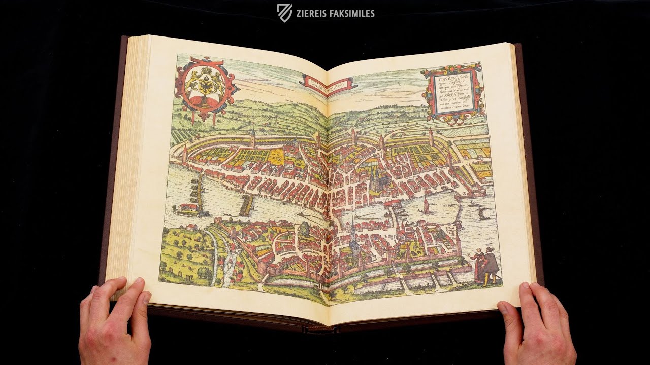
The Civitates Orbis Terrarum is famous for the hundreds of gorgeous cityscapes from around the world contained in its six volumes, which are particularly precious because they present the medieval cities of Europe before the destruction of the Thirty Years’ War. Cologne theologian, geographer, and printer Georg Braun and Flemish engraver Frans Hogenberg collaborated in creating the ambitious project, which has only gained popularity over the centuries. The masterfully designed and charmingly colored engravings not only depict buildings and their surrounding landscapes, but coats of arms, genre scenes from the everyday life of farmers and fishermen, local customs and costumes, boats, wagons, and more. Instructive and amusing texts written by Braun accompany the images and describe each town’s geographical location, historical development, and economic conditions. It was designed as a way of introducing the world to educated humanists. The third volume of the first German edition of this mammoth work was published in 1582 and contains 79 of the famous copperplate engravings.
Civitates Orbis Terrarum – 1582
Georg Braun's (1541–1622) impressive collection of city views of important cities in Europe, Asia, Africa, and America is considered the oldest work of its kind. The first Latin edition was published under the title Civitates Orbis Terrarum in six volumes between 1572 and 1617 and was translated into German shortly thereafter. The third volume of this German edition was printed in 1582 and contains 79 colored cityscapes and maps, including Verona, Chester, Zurich (labeled Tigurum), Landshut, Luxembourg, and Rotterdam.
An Significant Historical Source
The masterful copperplate engravings resembling stand-alone panel paintings not only stimulate the mind, but also offer limitless enjoyment to the eye thanks to their lovely design and artistic execution, with the numerous staffage and genre scenes being a particularly charming detail. The work is of outstanding historical importance because it provides a systematic mapping of the structures of many medieval cities, which were either destroyed or severely damaged the Thirty Years' War (1618–1648) shortly after its publication and subsequently rebuilt in the Baroque style.
Artistic Teamwork
As the author and editor of the Civitatis Orbis Terrarum, the Cologne theologian, canon, and dean Georg Braun undertook only a few journeys himself. Instead, he was able to obtain many templates through his numerous contacts, which were then initially converted into mostly double- page copperplate engravings by the engraver and etcher Frans Hogenberg (1535–1590), with the Flemish illuminator Georg Hoefnagel (1542–1590) regularly contributing. While the two were responsible for volumes I-IV, Frans' son Abraham and Simon Neuvelt took over volumes V and VI. Each of the wonderful city views is accompanied by descriptions of the geography, history, and economy of the respective city. In addition, there is information about the local coats of arms as well as elevation markers.
Slices of Life
The city views also contain small genre scenes depicting the lives of the inhabitants of these cities engaged in their daily activities, providing readers with insight into how the local population generally earned their livelihood. The farmers work the fields outside the towns, while the fishermen fish in the rivers that they are situated on. Further details such as carriages, ships, and contemporary costumes enliven the exquisite images and convey a realistic impression of everyday life around 1600. This gives us a unique insight into local customs and contemporary fashion.
Codicology
- Alternative Titles
- Georg Braun and Franz Hogenberg: Beschreibung und Contrafactur der Vornembster Stät der Welt 1574-1618
Beschreibung und Contrafactur der vornembster Stät der Welt
Städteansichten - Size / Format
- 1 volume - ca. 270 pages / 41.0 × 28.0 cm
- Origin
- Germany
- Date
- 1582
- Epochs
- Style
- Language
- Illustrations
- 79 colored, mostly double-page city views and maps
- Content
- Volume 3 of the German edition of the Civitates Orbis Terrarum: Atlas of important cities in Europe, Africa, Asia, and America
- Artist / School
- Georg Braun (1541–1622)
Frans Hogenberg (1535–1590)
Georg Hoefnagel (1542–1590)

Civitates Orbis Terrarum - 1582
Mariembourg
The fortress town of Mariembourg was built during the years 1542–46 at the behest of Mary of Hungary, the governor of the Hapsburg Netherlands after whom it is also named. It is designed as a start fort according to a symmetrical plan with eights streets radiating from a central square. A canal dug from either the Sambre or Meuse rivers provided water for the moat that surrounded Mariembourg for an extra layer of defense. Two extravagantly-dressed soldiers with swords, arquebusiers, and morions – open faced helmets with a distinctive crest or comb that originated from Castile – stand in the foreground.

Civitates Orbis Terrarum - 1582
Verona
This codex typically shows either maps or cityscapes of the world’s most important urban centers, but for a city as ancient and important as Verona, one of each has been provided on this splendid double page engraving in two registers. The city was already at least five centuries old when it became a Roman colony in 80 BC and played an important role in the later history of the Western Roman Empire.
A man sketches the city while sitting on a hill in the lower right corner of the upper register, presumably drawing the map shown in the lower register. There, Verona’s famous Roman arena is depicted on the right side while showing a pair of lovers on the left, an allusion to the tradition of tragic Italian romances that inspired Shakespeare to write Romeo and Juliet little more than a decade after this edition was published.

#1 Beschreibung und Contrafactur der Vornehmbster Stät der Welt - 1582
Language: German
(under 1,000€)

")
")


- Treatises / Secular Books
- Apocalypses / Beatus
- Astronomy / Astrology
- Bestiaries
- Bibles / Gospels
- Chronicles / History / Law
- Geography / Maps
- Saints' Lives
- Islam / Oriental
- Judaism / Hebrew
- Single Leaf Collections
- Leonardo da Vinci
- Literature / Poetry
- Liturgical Manuscripts
- Medicine / Botany / Alchemy
- Music
- Mythology / Prophecies
- Psalters
- Other Religious Books
- Games / Hunting
- Private Devotion Books
- Other Genres
- Afghanistan
- Armenia
- Austria
- Belgium
- Belize
- Bosnia and Herzegovina
- China
- Colombia
- Costa Rica
- Croatia
- Cyprus
- Czech Republic
- Denmark
- Egypt
- El Salvador
- Ethiopia
- France
- Germany
- Greece
- Guatemala
- Honduras
- Hungary
- India
- Iran
- Iraq
- Israel
- Italy
- Japan
- Jordan
- Kazakhstan
- Kyrgyzstan
- Lebanon
- Liechtenstein
- Luxembourg
- Mexico
- Morocco
- Netherlands
- Palestine
- Panama
- Peru
- Poland
- Portugal
- Romania
- Russia
- Serbia
- Spain
- Sri Lanka
- Sweden
- Switzerland
- Syria
- Tajikistan
- Turkey
- Turkmenistan
- Ukraine
- United Kingdom
- United States
- Uzbekistan
- Vatican City
- A. Oosthoek, van Holkema & Warendorf
- Aboca Museum
- Ajuntament de Valencia
- Akademie Verlag
- Akademische Druck- u. Verlagsanstalt (ADEVA)
- Aldo Ausilio Editore - Bottega d’Erasmo
- Alecto Historical Editions
- Alkuin Verlag
- Almqvist & Wiksell
- Amilcare Pizzi
- Andreas & Andreas Verlagsbuchhandlung
- Archa 90
- Archiv Verlag
- Archivi Edizioni
- Arnold Verlag
- ARS
- Ars Magna
- Ars Millenii
- Art Market
- ArtCodex
- AyN Ediciones
- Azimuth Editions
- Badenia Verlag
- Bärenreiter-Verlag
- Belser Verlag
- Belser Verlag / WK Wertkontor
- Benziger Verlag
- Bernardinum Wydawnictwo
- BiblioGemma
- Biblioteca Apostolica Vaticana (Vaticanstadt, Vaticanstadt)
- Bibliotheca Palatina Faksimile Verlag
- Bibliotheca Rara
- Boydell & Brewer
- Bramante Edizioni
- Bredius Genootschap
- Brepols Publishers
- British Library
- Brokarte
- C. Weckesser
- Caixa Catalunya
- Canesi
- CAPSA, Ars Scriptoria
- Caratzas Brothers, Publishers
- Carus Verlag
- Casamassima Libri
- Centrum Cartographie Verlag GmbH
- Chavane Verlag
- Christian Brandstätter Verlag
- Circulo Cientifico
- Club Bibliófilo Versol
- Club du Livre
- Club Internacional del Libro
- CM Editores
- Collegium Graphicum
- Collezione Apocrifa Da Vinci
- Comissão Nacional para as Comemorações dos Descobrimentos Portugueses
- Coron Verlag
- Corvina
- CTHS
- D. S. Brewer
- Damon
- De Agostini/UTET
- De Nederlandsche Boekhandel
- De Schutter
- Deuschle & Stemmle
- Deutscher Verlag für Kunstwissenschaft
- DIAMM
- Dropmore Press
- Droz
- E. Schreiber Graphische Kunstanstalten
- Ediciones Boreal
- Ediciones Grial
- Ediclube
- Edições Inapa
- Edilan
- Editalia
- Edition Deuschle
- Edition Georg Popp
- Edition Leipzig
- Edition Libri Illustri
- Editiones Reales Sitios S. L.
- Éditions de l'Oiseau Lyre
- Editions Medicina Rara
- Editorial Casariego
- Editorial Mintzoa
- Editrice Antenore
- Editrice Velar
- Edizioni Edison
- Egeria, S.L.
- Eikon Editores
- Electa
- Emery Walker Limited
- Enciclopèdia Catalana
- Eos-Verlag
- Ephesus Publishing
- Ernst Battenberg
- Eugrammia Press
- Extraordinary Editions
- Fackelverlag
- Facsimila Art & Edition
- Facsimile Editions Ltd.
- Facsimilia Art & Edition Ebert KG
- Faksimile Verlag
- Feuermann Verlag
- Folger Shakespeare Library
- Franco Cosimo Panini Editore
- Friedrich Wittig Verlag
- Fundación Hullera Vasco-Leonesa
- G. Braziller
- Gabriele Mazzotta Editore
- Gebr. Mann Verlag
- Gesellschaft für graphische Industrie
- Getty Research Institute
- Giovanni Domenico de Rossi
- Giunti Editore
- Goldenmark Librarium
- Graffiti
- Grafica European Center of Fine Arts
- Guido Pressler
- Guillermo Blazquez
- Gustav Kiepenheuer
- H. N. Abrams
- Harrassowitz
- Harvard University Press
- Helikon
- Hendrickson Publishers
- Henning Oppermann
- Herder Verlag
- Hes & De Graaf Publishers
- Hoepli
- Holbein-Verlag
- Houghton Library
- Hugo Schmidt Verlag
- Hungarian Academy of Sciences
- Idion Verlag
- Il Bulino, edizioni d'arte
- ILte
- Imago
- Insel Verlag
- Insel-Verlag Anton Kippenberger
- Instituto de Estudios Altoaragoneses
- Instituto Nacional de Antropología e Historia
- Introligatornia Budnik Jerzy
- Istituto dell'Enciclopedia Italiana - Treccani
- Istituto Ellenico di Studi Bizantini e Postbizantini
- Istituto Geografico De Agostini
- Istituto Poligrafico e Zecca dello Stato
- Italarte Art Establishments
- Jaca Book
- Jan Thorbecke Verlag
- Johnson Reprint Corporation
- Johnson Reprint Corporation
- Jos. Baer
- Josef Stocker
- Josef Stocker-Schmid
- Jugoslavija
- Karl W. Hiersemann
- Kasper Straube
- Kaydeda Ediciones
- Kindler Verlag / Coron Verlag
- Kodansha International Ltd.
- Konrad Kölbl Verlag
- Kurt Wolff Verlag
- La Liberia dello Stato
- La Linea Editrice
- La Meta Editore
- Lambert Schneider
- Landeskreditbank Baden-Württemberg
- Leo S. Olschki
- Les Incunables
- Liber Artis
- Library of Congress
- Libreria Musicale Italiana
- Lichtdruck
- Lito Immagine Editore
- Lumen Artis
- Lund Humphries
- M. Moleiro Editor
- Maison des Sciences de l'homme et de la société de Poitiers
- Manuscriptum
- Martinus Nijhoff
- Maruzen-Yushodo Co. Ltd.
- MASA
- Massada Publishers
- McGraw-Hill
- Metropolitan Museum of Art
- Militos
- Millennium Liber
- Müller & Schindler
- Nahar - Stavit
- Nahar and Steimatzky
- National Library of Wales
- Neri Pozza
- Nova Charta
- Oceanum Verlag
- Odeon
- Omnia Arte
- Orbis Mediaevalis
- Orbis Pictus
- Österreichische Staatsdruckerei
- Oxford University Press
- Pageant Books
- Parzellers Buchverlag
- Patrimonio Ediciones
- Pattloch Verlag
- PIAF
- Pieper Verlag
- Plon-Nourrit et cie
- Poligrafiche Bolis
- Presses Universitaires de Strasbourg
- Prestel Verlag
- Princeton University Press
- Prisma Verlag
- Priuli & Verlucca, editori
- Pro Sport Verlag
- Propyläen Verlag
- Pytheas Books
- Quaternio Verlag Luzern
- Reales Sitios
- Recht-Verlag
- Reichert Verlag
- Reichsdruckerei
- Reprint Verlag
- Riehn & Reusch
- Roberto Vattori Editore
- Rosenkilde and Bagger
- Roxburghe Club
- Salerno Editrice
- Saltellus Press
- Sandoz
- Sarajevo Svjetlost
- Schöck ArtPrint Kft.
- Schulsinger Brothers
- Scolar Press
- Scrinium
- Scripta Maneant
- Scriptorium
- Shazar
- Siloé, arte y bibliofilia
- SISMEL - Edizioni del Galluzzo
- Sociedad Mexicana de Antropología
- Société des Bibliophiles & Iconophiles de Belgique
- Soncin Publishing
- Sorli Ediciones
- Stainer and Bell
- Studer
- Styria Verlag
- Sumptibus Pragopress
- Szegedi Tudomànyegyetem
- Taberna Libraria
- Tarshish Books
- Taschen
- Tempus Libri
- Testimonio Compañía Editorial
- TGB Limited Editions
- Thames and Hudson
- The Clear Vue Publishing Partnership Limited
- The Facsimile Codex
- The Folio Society
- The Marquess of Normanby
- The Orphan Hospital Ward of Israel
- The Richard III and Yorkist History Trust
- The Warburg Institute
- Tip.Le.Co
- TouchArt
- TREC Publishing House
- TRI Publishing Co.
- Trident Editore
- Tuliba Collection
- Typis Regiae Officinae Polygraphicae
- Union Verlag Berlin
- Universidad de Granada
- Universitaire Bibliotheken Leiden
- University of California Press
- University of Chicago Press
- Urs Graf
- Vallecchi
- Van Wijnen
- VCH, Acta Humaniora
- VDI Verlag
- VEB Deutscher Verlag für Musik
- Verein Schweizerischer Lithographie-Besitzer
- Verlag Anton Pustet / Andreas Verlag
- Verlag Bibliophile Drucke Josef Stocker
- Verlag der Münchner Drucke
- Verlag für Regionalgeschichte
- Verlag Styria
- Vicent Garcia Editores
- W. Turnowsky
- Waanders Printers
- Wiener Mechitharisten-Congregation (Wien, Österreich)
- Wissenschaftliche Buchgesellschaft
- Wissenschaftliche Verlagsgesellschaft
- Wydawnictwo Dolnoslaskie
- Xuntanza Editorial
- Zakład Narodowy
- Zollikofer AG