Civitates Orbis Terrarum – Braun / Hogenberg 1574–1618

Cologne (Germany) — 1574–1618
One last historically and artistically precious look at the cities of Europe shortly before the destruction of the Thirty Years' War: a journey back in time to the 16th century with more than 600 fantastic city views
Georg Braun printed the first German edition of his popular city atlas between 1574 and 1618 in six comprehensive volumes
The more than 600 impressive city views and maps were created by Frans Hogenberg, Georg Hoefnagel, Abraham Hogenberg, and Simon Neuvelt
They not only show buildings, streets, and topography, but are also full of details about the clothing and everyday life of the citizens
Civitates Orbis Terrarum – Braun / Hogenberg 1574–1618


(1,000€ - 3,000€)
The Civitates Orbis Terrarum is famous for the hundreds of gorgeous cityscapes from around the world contained in its six volumes, which are particularly precious because they present the medieval cities of Europe before the destruction of the Thirty Years’ War. Cologne theologian, geographer, and printer Georg Braun and Flemish engraver Frans Hogenberg collaborated in creating the ambitious project, which has only gained popularity over the centuries. The masterfully designed and charmingly colored engravings not only depict buildings and their surrounding landscapes, but coats of arms, genre scenes from the everyday life of farmers and fishermen, local customs and costumes, boats, wagons, and more. Instructive and amusing texts written by Braun accompany the images and describe each town’s geographical location, historical development, and economic conditions. It was designed as a way of introducing the world to educated humanists.
Civitates Orbis Terrarum – Braun / Hogenberg 1574–1618
In 1570, Dutch geographer and cartographer Abraham Ortelius (1527–1598) published his famous Theatrum Orbis Terrarum – the first modern and commercially successful atlas of the world. The sensational work fascinated Flemish engraver Frans Hogenberg (1535–1590) and Cologne theologian, canon, and dean Georg Braun (1541–1622) so much that they decided to supplement it with an extensive collection of fantastic city views and maps.
A View of the Larger, Wider World
The result was the Civitates Orbis Terrarum, which was first published in Latin in six volumes between 1572 and 1617. The volumes of the first German edition were published shortly thereafter, between 1574 and 1618, under the title Beschreibung und Contrafactur der Vornembster Stät der Welt (Description and Contrafactur of the Most Important Cities of the World). The mammoth work brings together over 600 colored copperplate engravings on a total of ca. 1,600 pages, showing the most well-known and important cities of the 16th century from a European perspective. The view extends beyond Europe to Africa, Asia, and even the Americas. It is thus considered the oldest comprehensive collection of realistic and supraregional city views. In conjunction with the extensive additional information that complements the artistic representations, they still convey the joy of discovery and the desire to explore the larger, wider world.
An Significant Historical Source
However, the work derives its outstanding historical significance primarily from its systematic mapping of the structures of many medieval European cities, which still dominated urban topographies at the time of its creation. Shortly after the publication of the complete work, they were largely destroyed or severely damaged during the Thirty Years' War (1618–1648) and subsequently rebuilt in the Baroque style. The Civitates Orbis Terrarum thus offers a rare and valuable insight into the urban history of Europe, which is often difficult to reconstruct otherwise.
Artistic Teamwork
At first glance, this impressive work captivates with its more than 600 often double-page city views and maps, which are masterful, hand-colored copperplate engravings – each one a small work of art in its own right. In the first four volumes, they were created by Frans Hogenberg himself, with the Flemish illuminator Georg Hoefnagel (1542–1590) participating. However, as Frans died in 1590, the year the fourth volume was published, his son Abraham and Simon Neuvelt continued his work in the last two volumes. Neither the artists involved nor Georg Braun drew on personal sketches and observations from their own travels. Instead, Braun provided them with various samples that he obtained through his numerous, well-traveled contacts.
Slices of Life
The work becomes a complete atlas in the modern sense thanks to the additional information contained in each individual city view. The cities are embedded in the surrounding landscapes and often feature genre scenes or staffage in the foreground. There, the inhabitants are depicted in their everyday activities, providing information about traditional clothing, customs, and habits. Coats of arms and additional individual elevations complement the comprehensive insight offered by the various city views. They are complemented by texts by Georg Braun, which contain detailed descriptions of the geography, history, and economy of the cities and countries. This makes the collection a real treasure trove for humanists with wide-ranging interests and education.
Codicology
- Alternative Titles
- Georg Braun and Franz Hogenberg: Beschreibung und Contrafactur der Vornembster Stät der Welt 1574-1618
Beschreibung und Contrafactur der vornembster Stät der Welt
Städteansichten - Size / Format
- 6 volumes - 1,600 pages / 41.0 × 28.0 cm
- Origin
- Germany
- Date
- 1574–1618
- Epochs
- Style
- Language
- Illustrations
- More than 600 colored, mostly double-page city views and maps
- Content
- All 6 volumes of the German edition of the Civitates Orbis Terrarum: Atlas of important cities in Europe, Africa, Asia, and America
- Artist / School
- Georg Braun (1541–1622)
Frans Hogenberg (1535–1590)
Georg Hoefnagel (1542–1590)
Abraham Hogenberg (after 1578 – after 1653)
Simon Neuvelt


Civitates Orbis Terrarum - Braun / Hogenberg 1574-1618
Dresden
This cityscape of Dresden shows three wealthy residents strolling along the banks of the Elbe River, stylishly attired in the fashions of the late 16th century. The gentleman is dressed in puffy pantaloons and tights while the ladies wear elaborate dresses with countless skirts, stiff shirts, and exaggerated shoulders. A long stone bridge in the background connects the Old City of Dresden on the right with the growing Renaissance metropolis on the left.

Civitates Orbis Terrarum - Braun / Hogenberg 1574–1618
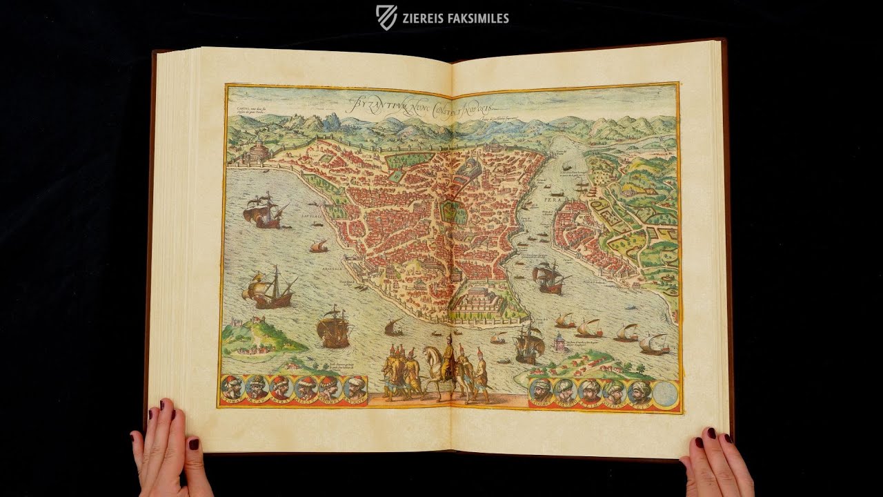
Venice
Venice is one of the most unique cities in the world, a cluster of 118 islands in a lagoon linked by bridges and canals and one of the most beautiful and romantic places in the world, which is renowned for its art, architecture, and culture. Its unique position, surrounded by water, made the city virtually impossible to take by force, allowing for the long and glorious history of the Republic of Venice.
This map of Venice is remarkable both for its artistry and its detail – the key at the bottom of the page, aside from portraying a procession of important officials, identifies well over one hundred locations in the city. Major landmarks are depicted with great accuracy, and the waters surrounding Venice are teeming with contemporary ships.

#1 Beschreibung und Contrafactur der vornembster Stät der Welt (Complete edition, 6 volumes, leather binding)
Language: German
Each facsimile volume is accompanied by a commentary volume that explains the city views contained therein, describes their sources, and provides translations of the inscriptions. Volume I also contains an introduction to the entire work.
(1,000€ - 3,000€)
#2 Beschreibung und Contrafactur der vornembster Stät der Welt (Complete edition, 6 volumes, cork binding)


Language: German
Each facsimile volume is accompanied by a commentary volume that explains the city views contained therein, describes their sources, and provides translations of the inscriptions. Volume I also contains an introduction to the entire work.
(1,000€ - 3,000€)
#3 Beschreibung und Contrafactur der vornebmster Stät der Welt

Language: German
(under 1,000€)
#4 Beschreibung und Contrafactur der vornembster Stät der Welt (Complete edition, 6 volumes, loose leaves)

Language: German
Each facsimile volume is accompanied by a commentary volume that explains the city views contained therein, describes their sources, and provides translations of the inscriptions. Volume I also contains an introduction to the entire work.
(1,000€ - 3,000€)
")
")


- Treatises / Secular Books
- Apocalypses / Beatus
- Astronomy / Astrology
- Bestiaries
- Bibles / Gospels
- Chronicles / History / Law
- Geography / Maps
- Saints' Lives
- Islam / Oriental
- Judaism / Hebrew
- Single Leaf Collections
- Leonardo da Vinci
- Literature / Poetry
- Liturgical Manuscripts
- Medicine / Botany / Alchemy
- Music
- Mythology / Prophecies
- Psalters
- Other Religious Books
- Games / Hunting
- Private Devotion Books
- Other Genres
- Afghanistan
- Armenia
- Austria
- Belgium
- Belize
- Bosnia and Herzegovina
- China
- Colombia
- Costa Rica
- Croatia
- Cyprus
- Czech Republic
- Denmark
- Egypt
- El Salvador
- Ethiopia
- France
- Germany
- Greece
- Guatemala
- Honduras
- Hungary
- India
- Iran
- Iraq
- Israel
- Italy
- Japan
- Jordan
- Kazakhstan
- Kyrgyzstan
- Lebanon
- Liechtenstein
- Luxembourg
- Mexico
- Morocco
- Netherlands
- Palestine
- Panama
- Peru
- Poland
- Portugal
- Romania
- Russia
- Serbia
- Spain
- Sri Lanka
- Sweden
- Switzerland
- Syria
- Tajikistan
- Turkey
- Turkmenistan
- Ukraine
- United Kingdom
- United States
- Uzbekistan
- Vatican City
- A. Oosthoek, van Holkema & Warendorf
- Aboca Museum
- Ajuntament de Valencia
- Akademie Verlag
- Akademische Druck- u. Verlagsanstalt (ADEVA)
- Aldo Ausilio Editore - Bottega d’Erasmo
- Alecto Historical Editions
- Alkuin Verlag
- Almqvist & Wiksell
- Amilcare Pizzi
- Andreas & Andreas Verlagsbuchhandlung
- Archa 90
- Archiv Verlag
- Archivi Edizioni
- Arnold Verlag
- ARS
- Ars Magna
- Ars Millenii
- Art Market
- ArtCodex
- AyN Ediciones
- Azimuth Editions
- Badenia Verlag
- Bärenreiter-Verlag
- Belser Verlag
- Belser Verlag / WK Wertkontor
- Benziger Verlag
- Bernardinum Wydawnictwo
- BiblioGemma
- Biblioteca Apostolica Vaticana (Vaticanstadt, Vaticanstadt)
- Bibliotheca Palatina Faksimile Verlag
- Bibliotheca Rara
- Boydell & Brewer
- Bramante Edizioni
- Bredius Genootschap
- Brepols Publishers
- British Library
- Brokarte
- C. Weckesser
- Caixa Catalunya
- Canesi
- CAPSA, Ars Scriptoria
- Caratzas Brothers, Publishers
- Carus Verlag
- Casamassima Libri
- Centrum Cartographie Verlag GmbH
- Chavane Verlag
- Christian Brandstätter Verlag
- Circulo Cientifico
- Club Bibliófilo Versol
- Club du Livre
- Club Internacional del Libro
- CM Editores
- Collegium Graphicum
- Collezione Apocrifa Da Vinci
- Comissão Nacional para as Comemorações dos Descobrimentos Portugueses
- Coron Verlag
- Corvina
- CTHS
- D. S. Brewer
- Damon
- De Agostini/UTET
- De Nederlandsche Boekhandel
- De Schutter
- Deuschle & Stemmle
- Deutscher Verlag für Kunstwissenschaft
- DIAMM
- Dropmore Press
- Droz
- E. Schreiber Graphische Kunstanstalten
- Ediciones Boreal
- Ediciones Grial
- Ediclube
- Edições Inapa
- Edilan
- Editalia
- Edition Deuschle
- Edition Georg Popp
- Edition Leipzig
- Edition Libri Illustri
- Editiones Reales Sitios S. L.
- Éditions de l'Oiseau Lyre
- Editions Medicina Rara
- Editorial Casariego
- Editorial Mintzoa
- Editrice Antenore
- Editrice Velar
- Edizioni Edison
- Egeria, S.L.
- Eikon Editores
- Electa
- Emery Walker Limited
- Enciclopèdia Catalana
- Eos-Verlag
- Ephesus Publishing
- Ernst Battenberg
- Eugrammia Press
- Extraordinary Editions
- Fackelverlag
- Facsimila Art & Edition
- Facsimile Editions Ltd.
- Facsimilia Art & Edition Ebert KG
- Faksimile Verlag
- Feuermann Verlag
- Folger Shakespeare Library
- Franco Cosimo Panini Editore
- Friedrich Wittig Verlag
- Fundación Hullera Vasco-Leonesa
- G. Braziller
- Gabriele Mazzotta Editore
- Gebr. Mann Verlag
- Gesellschaft für graphische Industrie
- Getty Research Institute
- Giovanni Domenico de Rossi
- Giunti Editore
- Goldenmark Librarium
- Graffiti
- Grafica European Center of Fine Arts
- Guido Pressler
- Guillermo Blazquez
- Gustav Kiepenheuer
- H. N. Abrams
- Harrassowitz
- Harvard University Press
- Helikon
- Hendrickson Publishers
- Henning Oppermann
- Herder Verlag
- Hes & De Graaf Publishers
- Hoepli
- Holbein-Verlag
- Houghton Library
- Hugo Schmidt Verlag
- Hungarian Academy of Sciences
- Idion Verlag
- Il Bulino, edizioni d'arte
- ILte
- Imago
- Insel Verlag
- Insel-Verlag Anton Kippenberger
- Instituto de Estudios Altoaragoneses
- Instituto Nacional de Antropología e Historia
- Introligatornia Budnik Jerzy
- Istituto dell'Enciclopedia Italiana - Treccani
- Istituto Ellenico di Studi Bizantini e Postbizantini
- Istituto Geografico De Agostini
- Istituto Poligrafico e Zecca dello Stato
- Italarte Art Establishments
- Jaca Book
- Jan Thorbecke Verlag
- Johnson Reprint Corporation
- Johnson Reprint Corporation
- Jos. Baer
- Josef Stocker
- Josef Stocker-Schmid
- Jugoslavija
- Karl W. Hiersemann
- Kasper Straube
- Kaydeda Ediciones
- Kindler Verlag / Coron Verlag
- Kodansha International Ltd.
- Konrad Kölbl Verlag
- Kurt Wolff Verlag
- La Liberia dello Stato
- La Linea Editrice
- La Meta Editore
- Lambert Schneider
- Landeskreditbank Baden-Württemberg
- Leo S. Olschki
- Les Incunables
- Liber Artis
- Library of Congress
- Libreria Musicale Italiana
- Lichtdruck
- Lito Immagine Editore
- Lumen Artis
- Lund Humphries
- M. Moleiro Editor
- Maison des Sciences de l'homme et de la société de Poitiers
- Manuscriptum
- Martinus Nijhoff
- Maruzen-Yushodo Co. Ltd.
- MASA
- Massada Publishers
- McGraw-Hill
- Metropolitan Museum of Art
- Militos
- Millennium Liber
- Müller & Schindler
- Nahar - Stavit
- Nahar and Steimatzky
- National Library of Wales
- Neri Pozza
- Nova Charta
- Oceanum Verlag
- Odeon
- Omnia Arte
- Orbis Mediaevalis
- Orbis Pictus
- Österreichische Staatsdruckerei
- Oxford University Press
- Pageant Books
- Parzellers Buchverlag
- Patrimonio Ediciones
- Pattloch Verlag
- PIAF
- Pieper Verlag
- Plon-Nourrit et cie
- Poligrafiche Bolis
- Presses Universitaires de Strasbourg
- Prestel Verlag
- Princeton University Press
- Prisma Verlag
- Priuli & Verlucca, editori
- Pro Sport Verlag
- Propyläen Verlag
- Pytheas Books
- Quaternio Verlag Luzern
- Reales Sitios
- Recht-Verlag
- Reichert Verlag
- Reichsdruckerei
- Reprint Verlag
- Riehn & Reusch
- Roberto Vattori Editore
- Rosenkilde and Bagger
- Roxburghe Club
- Salerno Editrice
- Saltellus Press
- Sandoz
- Sarajevo Svjetlost
- Schöck ArtPrint Kft.
- Schulsinger Brothers
- Scolar Press
- Scrinium
- Scripta Maneant
- Scriptorium
- Shazar
- Siloé, arte y bibliofilia
- SISMEL - Edizioni del Galluzzo
- Sociedad Mexicana de Antropología
- Société des Bibliophiles & Iconophiles de Belgique
- Soncin Publishing
- Sorli Ediciones
- Stainer and Bell
- Studer
- Styria Verlag
- Sumptibus Pragopress
- Szegedi Tudomànyegyetem
- Taberna Libraria
- Tarshish Books
- Taschen
- Tempus Libri
- Testimonio Compañía Editorial
- TGB Limited Editions
- Thames and Hudson
- The Clear Vue Publishing Partnership Limited
- The Facsimile Codex
- The Folio Society
- The Marquess of Normanby
- The Orphan Hospital Ward of Israel
- The Richard III and Yorkist History Trust
- The Warburg Institute
- Tip.Le.Co
- TouchArt
- TREC Publishing House
- TRI Publishing Co.
- Trident Editore
- Tuliba Collection
- Typis Regiae Officinae Polygraphicae
- Union Verlag Berlin
- Universidad de Granada
- Universitaire Bibliotheken Leiden
- University of California Press
- University of Chicago Press
- Urs Graf
- Vallecchi
- Van Wijnen
- VCH, Acta Humaniora
- VDI Verlag
- VEB Deutscher Verlag für Musik
- Verein Schweizerischer Lithographie-Besitzer
- Verlag Anton Pustet / Andreas Verlag
- Verlag Bibliophile Drucke Josef Stocker
- Verlag der Münchner Drucke
- Verlag für Regionalgeschichte
- Verlag Styria
- Vicent Garcia Editores
- W. Turnowsky
- Waanders Printers
- Wiener Mechitharisten-Congregation (Wien, Österreich)
- Wissenschaftliche Buchgesellschaft
- Wissenschaftliche Verlagsgesellschaft
- Wydawnictwo Dolnoslaskie
- Xuntanza Editorial
- Zakład Narodowy
- Zollikofer AG