Contrafactur der Vornebster Stät der Welt
")
Cologne (Germany) — 1574–1618
One of the most important sources on the original appearance and structure of medieval towns: 90 selected cityscapes from the famous compendium by Franz Hogenberg and Georg Braun
This is a selection of 90 cityscapes and maps from the fabulous six-volume Civitatis Orbis Terrarum
An extremely popular masterpiece by Frans Hogenberg and Simon van den Neuwel, printed by Georg Braun
These depictions are of tremendous importance today for our knowledge of medieval city structures
Contrafactur der Vornebster Stät der Welt

")
")
")
")
")
")
")
")
")
")
")
")
")
")
")
")
")
(under 1,000€)
Between 1574 and 1618, the Cologne-based theologian Georg Braun (1541–1622) and the Flemish copperplate engraver Franz Hogenberg (1535–1590) published the six-volume work Civitatis Orbis Terrarum. The Contrafactur der Vornebster Stät der Welt is a selection of 90 cityscapes and maps from this impressive work, which set new standards and which served for a century as a template and rich source for other printed works. Franz Hohenberg still fascinates the modern beholder with his lavish and realistic representations that carry them off into the medieval cities of Europe, Africa, Asia, and even America.
Contrafactur der Vornebster Stät der Welt
The Cologne-based theologian Georg Braun (1541–1622) and the Flemish copperplate engraver Franz Hogenberg (1535–1590) already published the six-volume work Civitatis Orbis Terrarum two generations before Matthäus Merian. Featuring over 600 cityscapes and maps, it was trendsetting and functioned as a template and rich source for other works. There is now a selection of 90 realistic depictions on 56 double-pages from this great collection. Graphics of all sizes depicting cities in Europe, Africa, Asia, and America originated between 1574 and 1618.
Successful Duo
The theologian, canon, and dean from Cologne, Georg Braun (1541–1622) undertook only a few journeys himself as the author and publisher of the Civitatis Orbis Terrarum. Instead, he was able to obtain many examples through his numerous contacts, which could then be executed by the copperplate engraver and etcher Franz Hogenberg (1535–1590). In addition to the lavishly designed and richly colored prints, the information about the geographical location, historical development, and economic situation of all the cities were contained in accompanying texts written by Braun in an entertaining and informative manner.
Evidence of Urban Development
These cityscapes and maps are of tremendous importance today for our knowledge of medieval city structures. They expand our knowledge of the cities and their destruction in the 30 Years’ War and their subsequent renovation in the Baroque style. Furthermore, the extremely detailed depictions contain much additional information with their coats of arms and the small genre scenes showing the lives of the farmers and fishermen. The modern beholder thus receives an inside look into local customs and learns contemporary fashions.
Codicology
- Alternative Titles
- Civitates Orbis Terrarum
Städteansichten - Contrafactur der Vornebster Stät der Welt
Beschreibung und Contrafactur der vornembster Stät der Welt - Size / Format
- 248 pages / 43.0 × 70.0 cm
- Origin
- Germany
- Date
- 1574–1618
- Epochs
- Style
- Genre
- Language
- Illustrations
- 56 double-pages with 90 cityscapes
- Artist / School
- Franz Hogenberg (1535–1590)
Georg Braun (1541–1622)
")
Contrafactur der Vornebster Stät der Welt
Frontispiece
Seated on a throne on top of a stone inscribed with the title of the work at hand, a regnal female figure is shown holding the drafting tools of a cartographer as though they were royal regalia: she has a simple square and compass in her left hand while holding a T-square like a scepter in the other. The queen of cartography is dressed in brightly colored classical robes with her gaze fixed squarely on the beholder. It is a wonderful woodcut giving us a preview of the work’s refinement.
")
Contrafactur der Vornebster Stät der Welt
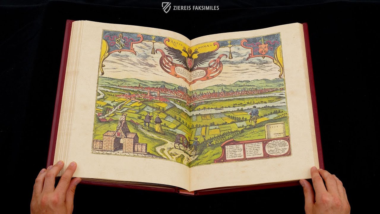
Cityscape of Regensburg
Identified by its French name – Ratisbona – the city of Regensburg is depicted in a view from the hills to the north. The imperial eagle designates it as a free city of the Holy Roman Empire, with the crossed keys of Regensburg’s coat of arms on the right and the arms of the Wittelsbach family, the ruling house of Bavaria, on the left.
With the help of the key in the lower-right corner, this splendid copperplate identifies important sites in the city, including monastic communities, the cathedral, bishop’s residence, and town hall. The confluence of the rivers Danube and Regen, for which Regensburg is named, is shown on the far left. Regensburg’s red-tiled roofs and Italian trade connections have caused it to be dubbed “Italy’s most northern city”.
")
#1 Städteansichten - Contrafactur der Vornebster Stät der Welt
Language: German
(under 1,000€)

")


- Treatises / Secular Books
- Apocalypses / Beatus
- Astronomy / Astrology
- Bestiaries
- Bibles / Gospels
- Chronicles / History / Law
- Geography / Maps
- Saints' Lives
- Islam / Oriental
- Judaism / Hebrew
- Single Leaf Collections
- Leonardo da Vinci
- Literature / Poetry
- Liturgical Manuscripts
- Medicine / Botany / Alchemy
- Music
- Mythology / Prophecies
- Psalters
- Other Religious Books
- Games / Hunting
- Private Devotion Books
- Other Genres
- Afghanistan
- Armenia
- Austria
- Belgium
- Belize
- Bosnia and Herzegovina
- China
- Colombia
- Costa Rica
- Croatia
- Cyprus
- Czech Republic
- Denmark
- Egypt
- El Salvador
- Ethiopia
- France
- Germany
- Greece
- Guatemala
- Honduras
- Hungary
- India
- Iran
- Iraq
- Israel
- Italy
- Japan
- Jordan
- Kazakhstan
- Kyrgyzstan
- Lebanon
- Liechtenstein
- Luxembourg
- Mexico
- Morocco
- Netherlands
- Palestine
- Panama
- Peru
- Poland
- Portugal
- Romania
- Russia
- Serbia
- Spain
- Sri Lanka
- Sweden
- Switzerland
- Syria
- Tajikistan
- Turkey
- Turkmenistan
- Ukraine
- United Kingdom
- United States
- Uzbekistan
- Vatican City
- A. Oosthoek, van Holkema & Warendorf
- Aboca Museum
- Ajuntament de Valencia
- Akademie Verlag
- Akademische Druck- u. Verlagsanstalt (ADEVA)
- Aldo Ausilio Editore - Bottega d’Erasmo
- Alecto Historical Editions
- Alkuin Verlag
- Almqvist & Wiksell
- Amilcare Pizzi
- Andreas & Andreas Verlagsbuchhandlung
- Archa 90
- Archiv Verlag
- Archivi Edizioni
- Arnold Verlag
- ARS
- Ars Magna
- Ars Millenii
- Art Market
- ArtCodex
- AyN Ediciones
- Azimuth Editions
- Badenia Verlag
- Bärenreiter-Verlag
- Belser Verlag
- Belser Verlag / WK Wertkontor
- Benziger Verlag
- Bernardinum Wydawnictwo
- BiblioGemma
- Biblioteca Apostolica Vaticana (Vaticanstadt, Vaticanstadt)
- Bibliotheca Palatina Faksimile Verlag
- Bibliotheca Rara
- Boydell & Brewer
- Bramante Edizioni
- Bredius Genootschap
- Brepols Publishers
- British Library
- Brokarte
- C. Weckesser
- Caixa Catalunya
- Canesi
- CAPSA, Ars Scriptoria
- Caratzas Brothers, Publishers
- Carus Verlag
- Casamassima Libri
- Centrum Cartographie Verlag GmbH
- Chavane Verlag
- Christian Brandstätter Verlag
- Circulo Cientifico
- Club Bibliófilo Versol
- Club du Livre
- Club Internacional del Libro
- CM Editores
- Collegium Graphicum
- Collezione Apocrifa Da Vinci
- Comissão Nacional para as Comemorações dos Descobrimentos Portugueses
- Coron Verlag
- Corvina
- CTHS
- D. S. Brewer
- Damon
- De Agostini/UTET
- De Nederlandsche Boekhandel
- De Schutter
- Deuschle & Stemmle
- Deutscher Verlag für Kunstwissenschaft
- DIAMM
- Dropmore Press
- Droz
- E. Schreiber Graphische Kunstanstalten
- Ediciones Boreal
- Ediciones Grial
- Ediclube
- Edições Inapa
- Edilan
- Editalia
- Edition Deuschle
- Edition Georg Popp
- Edition Leipzig
- Edition Libri Illustri
- Editiones Reales Sitios S. L.
- Éditions de l'Oiseau Lyre
- Editions Medicina Rara
- Editorial Casariego
- Editorial Mintzoa
- Editrice Antenore
- Editrice Velar
- Edizioni Edison
- Egeria, S.L.
- Eikon Editores
- Electa
- Emery Walker Limited
- Enciclopèdia Catalana
- Eos-Verlag
- Ephesus Publishing
- Ernst Battenberg
- Eugrammia Press
- Extraordinary Editions
- Fackelverlag
- Facsimila Art & Edition
- Facsimile Editions Ltd.
- Facsimilia Art & Edition Ebert KG
- Faksimile Verlag
- Feuermann Verlag
- Folger Shakespeare Library
- Franco Cosimo Panini Editore
- Friedrich Wittig Verlag
- Fundación Hullera Vasco-Leonesa
- G. Braziller
- Gabriele Mazzotta Editore
- Gebr. Mann Verlag
- Gesellschaft für graphische Industrie
- Getty Research Institute
- Giovanni Domenico de Rossi
- Giunti Editore
- Goldenmark Librarium
- Graffiti
- Grafica European Center of Fine Arts
- Guido Pressler
- Guillermo Blazquez
- Gustav Kiepenheuer
- H. N. Abrams
- Harrassowitz
- Harvard University Press
- Helikon
- Hendrickson Publishers
- Henning Oppermann
- Herder Verlag
- Hes & De Graaf Publishers
- Hoepli
- Holbein-Verlag
- Houghton Library
- Hugo Schmidt Verlag
- Hungarian Academy of Sciences
- Idion Verlag
- Il Bulino, edizioni d'arte
- ILte
- Imago
- Insel Verlag
- Insel-Verlag Anton Kippenberger
- Instituto de Estudios Altoaragoneses
- Instituto Nacional de Antropología e Historia
- Introligatornia Budnik Jerzy
- Istituto dell'Enciclopedia Italiana - Treccani
- Istituto Ellenico di Studi Bizantini e Postbizantini
- Istituto Geografico De Agostini
- Istituto Poligrafico e Zecca dello Stato
- Italarte Art Establishments
- Jaca Book
- Jan Thorbecke Verlag
- Johnson Reprint Corporation
- Johnson Reprint Corporation
- Jos. Baer
- Josef Stocker
- Josef Stocker-Schmid
- Jugoslavija
- Karl W. Hiersemann
- Kasper Straube
- Kaydeda Ediciones
- Kindler Verlag / Coron Verlag
- Kodansha International Ltd.
- Konrad Kölbl Verlag
- Kurt Wolff Verlag
- La Liberia dello Stato
- La Linea Editrice
- La Meta Editore
- Lambert Schneider
- Landeskreditbank Baden-Württemberg
- Leo S. Olschki
- Les Incunables
- Liber Artis
- Library of Congress
- Libreria Musicale Italiana
- Lichtdruck
- Lito Immagine Editore
- Lumen Artis
- Lund Humphries
- M. Moleiro Editor
- Maison des Sciences de l'homme et de la société de Poitiers
- Manuscriptum
- Martinus Nijhoff
- Maruzen-Yushodo Co. Ltd.
- MASA
- Massada Publishers
- McGraw-Hill
- Metropolitan Museum of Art
- Militos
- Millennium Liber
- Müller & Schindler
- Nahar - Stavit
- Nahar and Steimatzky
- National Library of Wales
- Neri Pozza
- Nova Charta
- Oceanum Verlag
- Odeon
- Omnia Arte
- Orbis Mediaevalis
- Orbis Pictus
- Österreichische Staatsdruckerei
- Oxford University Press
- Pageant Books
- Parzellers Buchverlag
- Patrimonio Ediciones
- Pattloch Verlag
- PIAF
- Pieper Verlag
- Plon-Nourrit et cie
- Poligrafiche Bolis
- Presses Universitaires de Strasbourg
- Prestel Verlag
- Princeton University Press
- Prisma Verlag
- Priuli & Verlucca, editori
- Pro Sport Verlag
- Propyläen Verlag
- Pytheas Books
- Quaternio Verlag Luzern
- Reales Sitios
- Recht-Verlag
- Reichert Verlag
- Reichsdruckerei
- Reprint Verlag
- Riehn & Reusch
- Roberto Vattori Editore
- Rosenkilde and Bagger
- Roxburghe Club
- Salerno Editrice
- Saltellus Press
- Sandoz
- Sarajevo Svjetlost
- Schöck ArtPrint Kft.
- Schulsinger Brothers
- Scolar Press
- Scrinium
- Scripta Maneant
- Scriptorium
- Shazar
- Siloé, arte y bibliofilia
- SISMEL - Edizioni del Galluzzo
- Sociedad Mexicana de Antropología
- Société des Bibliophiles & Iconophiles de Belgique
- Soncin Publishing
- Sorli Ediciones
- Stainer and Bell
- Studer
- Styria Verlag
- Sumptibus Pragopress
- Szegedi Tudomànyegyetem
- Taberna Libraria
- Tarshish Books
- Taschen
- Tempus Libri
- Testimonio Compañía Editorial
- TGB Limited Editions
- Thames and Hudson
- The Clear Vue Publishing Partnership Limited
- The Facsimile Codex
- The Folio Society
- The Marquess of Normanby
- The Orphan Hospital Ward of Israel
- The Richard III and Yorkist History Trust
- The Warburg Institute
- Tip.Le.Co
- TouchArt
- TREC Publishing House
- TRI Publishing Co.
- Trident Editore
- Tuliba Collection
- Typis Regiae Officinae Polygraphicae
- Union Verlag Berlin
- Universidad de Granada
- Universitaire Bibliotheken Leiden
- University of California Press
- University of Chicago Press
- Urs Graf
- Vallecchi
- Van Wijnen
- VCH, Acta Humaniora
- VDI Verlag
- VEB Deutscher Verlag für Musik
- Verein Schweizerischer Lithographie-Besitzer
- Verlag Anton Pustet / Andreas Verlag
- Verlag Bibliophile Drucke Josef Stocker
- Verlag der Münchner Drucke
- Verlag für Regionalgeschichte
- Verlag Styria
- Vicent Garcia Editores
- W. Turnowsky
- Waanders Printers
- Wiener Mechitharisten-Congregation (Wien, Österreich)
- Wissenschaftliche Buchgesellschaft
- Wissenschaftliche Verlagsgesellschaft
- Wydawnictwo Dolnoslaskie
- Xuntanza Editorial
- Zakład Narodowy
- Zollikofer AG